|

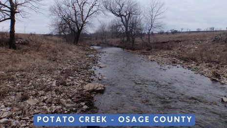
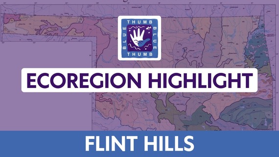 The Flint Hills (FH) Ecoregion extends from northeastern Oklahoma into Kansas. The Oklahoma portion of the ecoregion lies mostly in Osage County. The landscape is dominated by rolling hills of tallgrass prairie. In addition to tallgrass prairie habitat, there are smaller areas of shortgrass prairie and bottomland forest. Streams in this ecoregion drain to the Arkansas River and are usually low-gradient and clear. Fish assemblages in the FH are similar to those in the Cross Timbers ecoregion and include channel catfish, flathead catfish, black and golden redhorses, and smallmouth buffalo. The Joseph H. Williams Tallgrass Prairie Preserve in Osage County is a wonderful example of FH prairie habitat. The preserve encompasses 39,650 acres of pristine prairie and is the largest protected piece of tallgrass prairie in the world. The preserve is managed by The Nature Conservancy and is home to 2,500 bison that play a critical role in the ecosystem.
 |
Hello Volunteers! I hope you read your June From the Water’s Edge, and if indeed you did, then you learned about some new invertebrates being added to the list of Oklahoma State emblems. The bill is called the Lucile Morehouse State Pollinator Act (#2065) and will become law November 1 of this year. Lucile agreed to provide to us a little more information about herself, hence the article below. Share with your friends and neighbors the importance of our pollinators, and let’s work together create a world that treats these creatures more kindly.
Cheryl Cheadle
Blue Thumb Volunteer Coordinator
My name is Lucile Morehouse, and I am a 15-year-old Epic Charter School student from Boswell, Oklahoma. I serve as an Oklahoma 4-H State Ambassador, Oklahoma 4-H State STEM Innovator, and Global Youth Ambassador. When I was 11 years old, I founded Lucile’s Pollinator Project to educate others about the importance of pollinators and to encourage habitat creation. Through the project, I have distributed more than 8,400 packets of pollinator seed to all 50 states, as well as Germany and the United Kingdom, helping create over 100,000 square feet of pollinator habitat.
Most recently, I worked to nominate four species as official Oklahoma state symbols through the Lucile Morehouse Pollinator Project Act. The legislation recognizes the European Honey Bee as the Oklahoma Agricultural Pollinator, the American Bumble Bee as the Oklahoma Native Pollinator, the Carolina Mantis as the Oklahoma Predator Insect, and the Rainbow Scarab as the Oklahoma Soil Conservation Insect. My goal is to help increase awareness of the important role insects play in agriculture, conservation, and healthy ecosystems.
I have been fortunate to receive recognition through the EPA Presidential Environmental Youth Award, the International Young Eco-Hero Award, and the Global Youth Awards. In the future, I hope to continue combining conservation, leadership, and education to make a positive impact in Oklahoma and beyond.
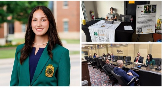 Lucile Morehouse
Oklahoma 4-H State Ambassador
It is obvious that fish need water to live, but what is less obvious is why some waters support fish communities while others do not. Additionally, why do some species only persist in specific aquatic environments whereas other species seem to thrive anywhere? The short answer is that aquatic habitat is complex. The quantity and quality of water is important, but so is the range in temperature, the substrate of the stream bed, the availability of cover in the water column, and the changes in water flow through the habitat. Fish require specific habitat to spawn, forage and grow, and shelter. For some species these different habitats are in close proximity, but for others it is necessary to migrate long distances to access these specific habitats.
Blue Sucker are a big-river obligate species that occur throughout the Red River below Lake Texoma. For most of the year, Blue Sucker occupy the mainstem of the Red River, but in springtime when warming temperatures coincide with large flow pulses, individuals will migrate from just below Denison Dam or beyond the Arkansas border to spawn in the Blue, Muddy Boggy, and Kiamichi rivers. Unlike the Red River, these tributaries have steep-gradient riffles with large, cobble and boulder substrate, or in other words, the required spawning habitat for Blue Sucker. Investigation of the age structure of the population indicated that early spring flow pulses in Muddy Boggy and stable summer flows in the Red River produced the strongest year classes in the Blue Sucker population below Denison Dam. However, the population in the Kiamichi River, below Hugo Dam, appeared to be shrinking each year. When considering this evidence in the context of dam operation, it appeared that the free-flowing Muddy Boggy River supported the population below Denison Dam, but dam operations in the Kiamichi River likely lured Blue Suckers to spawn, only to leave the nests stranded in dry rocks when the dam gates were closed. One final point on the effects of dams on Blue Suckers is that Blue Sucker were not found upstream of either dam. Blue Sucker have historically occurred in the Arkansas River as well, but they may now be extirpated due to the high degree of fragmentation throughout the river.
Dams that create large reservoirs negatively affect several big-river obligate fishes including Alligator Gar, Eel, Paddlefish and Sturgeon, but road crossings also have the potential to negatively affect stream fishes in smaller wadeable streams. These road crossings not only create physical barriers but also change the flow regime and alter habitat. When the stream flow is constricted through culverts or concrete structures, the water velocity can exceed the swimming capability of native fishes, effectively creating a barrier. Further, when flow is restricted, the road crossing can have a damming effect creating a small impoundment that is much different from the natural stream environment. By retaining water, these stream crossings have an effect like a flood control dam that suppresses small flow pulses and amplifies large flows. The results are fragmented streams, altered habitat, and interrupted spawning cues.
OCC and the Oklahoma Wildlife Department have taken the lead in partnering with the Southeastern Aquatic Resources Partnership to inventory and work toward replacing problematic road crossings. Members of other state agencies, nonprofit organizations, and universities are pitching in to assist with surveying and contributing to the inventory of road crossings across the state.
Joey Dyer
OCC Freshwater Ecologist/Data Analyst
Blue Thumb is considering facilitating an opportunity for volunteers to participate in assessing road crossings. We would select a watershed and spend a day evaluating crossings. If you would be interested in participating in a road crossing inventory event, please contact us!
Trail Marker Trees
I am a member of the Oklahoma Native Plant Society and I get their seasonal newsletter. The summer edition was full of great photographs of events and field trips, and one photo in particular caught my eye – a blackjack oak tree in the Keystone Ancient Forest (near Sand Springs) that had been pulled over and tied as a sapling so that a portion of the tree’s main trunk was completely horizontal. I recognized it as a trail marker tree, also called a signal tree, and the photograph’s caption confirmed this.
History reflects that for hundreds – maybe thousands- of years, indigenous people would use ligaments, plant-based ropes, even heavy stones to alter the growth of a young tree to serve as a signal, to communicate something important. As the tree grew, instead of becoming straight and tall, the main trunk would succumb to be being bound and it would grow horizontally, maybe pointing in a particular direction. At some point in the tree’s life it was likely to again grow vertically again, leaving behind a sort of seat. In some cases, a limb of a tree might be used instead. The modified limb or the main trunk would very likely have a meaning to which way it pointed.
Perhaps the marker tree was meant to keep fellow tribal members going in a certain direction, perhaps it pointed toward a spring that could be depended upon to always yield a drink. Probably when the practice first began, it was long enough ago that those trees have by now died of old age. Trees that were recently bent, perhaps in the last 400 to 500 years might still be out there (as is the one in the Keystone Ancient Forest). Have any been lost to wildfires? To farming? To urbanization?
To give a few minutes of time to consider marker trees is to fall into a mental whirlwind of history, culture, fighting for survival, and considering those who will pass this way when we are gone. Trail marker trees are of great historical significance, and would we know one if we saw it? Trees can make interesting bends and turns all on their own.
I read a book about Comanche trail marker trees during Covid time, and I took up the habit of trying to find trail marker trees in every park and forested area I encountered. Maybe I found some, or maybe they were just unique trees. I was in a pasture with a landowner way in north Oklahoma scouting around in the trees, and without me saying a word he said “Do you suppose this might be one of those Indian marker trees?” We both looked at the well bent tree in question and decided, yes, indeed this was a historical tree that had been bent intentionally to help others navigate the way before cars, highways, airplanes, and cellphones.
Cheryl Cheadle
Blue Thumb Volunteer Coordinator
|
|
|
We get asked this question a lot: “How many Blue Thumb sites are there?” Well, that number is always changing. Volunteers come and go for many different reasons which is why the number of actively monitored Blue Thumb creek sites is always changing. I am writing about this because we recently had a training in Norman June 9-10 and this question always comes up at trainings. Also, Rebecca recently requested an active site listing to submit along with our Quality Assurance Project Plan (QAPP) recertification letter to EPA. So, I have some concrete numbers for this question (as of 9am June 18th). In Blue Thumb’s history, we have established at least 478 monitoring sites in 65 counties, and I am in the process of adding three more sites. We currently have 113 actively monitored creek sites in 30 counties; from May 2025 to May 2026 that have had at least one monitoring episode. We try and put new trainees on established creek sites, but sometimes they don’t live near an established site, or they have a creek on their land, or a historical site is not viable anymore, etc. The total number of Blue Thumb sites ever monitored increases slowly because we try our best to assign new volunteers to creeks that have been monitored in the past.
Another similar question we get asked is, “How many Blue Thumb volunteers are there?”. This is way harder to answer. As I’ve stated above, people come and go with the program for MANY different reasons. And some people become active again when their life allows more time. Some creek sites have a monitoring team, some sites are monitored by one person, and some sites are headed by a teacher/professor who has many students come and go during their time as a Blue Thumb volunteer. Some volunteers just help with education, and this number has really exploded with the addition of Jack Hilgert who heads up Projects WET/WILD. If you’ve been through a Blue Thumb or WET/WILD training we consider you a Blue Thumb volunteer for life! Whether you are active or not is up to you.
So, thanks for the hard questions. I hope I've answered one of them at least.
Kim Shaw
Blue Thumb QA Officer
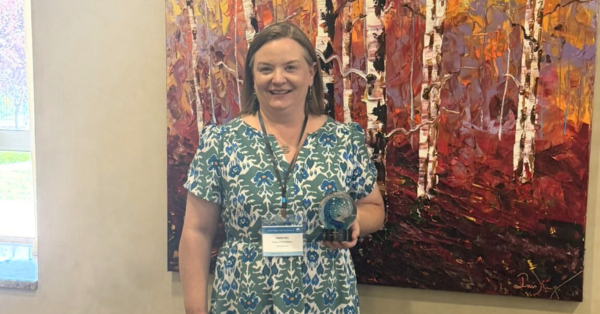 The Project WET Foundation and Oklahoma Conservation Commission are proud to announce that Sara Ivey was awarded the 2026 Project WET Facilitator of the Year Award. Presented at the Project WET Annual Conference in Santa Fe, New Mexico, on May 12, 2026, this national award honors individuals who demonstrate exceptional leadership in environmental education, especially regarding water education and Project WET.
Sara serves as the Education Programs and Services Coordinator for the Oklahoma Department of Environmental Quality (ODEQ) and Treasurer for the Oklahoma Association for Environmental Education (OKAEE), where she helps guide educators, inspires students, and brings partners together to deepen our understanding of our most vital natural resources. Since completing Project WET facilitator training in 2007, Sara has introduced countless educators to the program's engaging, inquiry-based approach to water education.
"Sara Ivey is a vital asset to Oklahoma's Project WET program and our state's environmental education community as a whole. She has led countless Project WET workshops and water festivals across the state, helping educators and students better understand water and the world around them," said Jack Hilgert, Statewide Environmental Education Coordinator and Oklahoma Project WET Coordinator with the Oklahoma Conservation Commission.
Project WET empowers educators to engage youth in understanding water and solving local and global challenges. Through a network of state-level partners and grassroots, community-based volunteers called facilitators, Project WET reaches over 10,000 educators and millions of students each year across the United States. In Oklahoma, the program is coordinated by the Blue Thumb Program within the Oklahoma Conservation Commission, and 86 passionate volunteers serve as Project WET facilitators across the state.
Today, Sara serves as a Project WET workshop facilitator, steering committee member, and helps organize the annual H2Oklahoma Water Festivals, which engage thousands of students, teachers, and volunteers across multiple locations each year. Sara connects agencies, educators, nonprofits, and volunteers to strengthen environmental education statewide, demonstrating the interconnectedness of water, ecosystems, communities, and education.
"In Oklahoma's environmental education community, Sara Ivey is one of the people who makes the entire ecosystem function. Sara is truly the 'glue person' connecting Oklahoma's environmental education efforts," Tony Pascall, Education Coordinator for Oklahoma Forestry Services and OKAEE Board President, shared.
Any schools, educators, or organizations interested in Project WET in Oklahoma can learn more about scheduling professional development workshops, H2Oklahoma Water Festivals, or other environmental education programming by contacting Jack Hilgert, jack.hilgert@conservation.ok.gov or (405) 613-3835
Learn more about Project WET in Oklahoma here: Project WET & Project WILD - Blue Thumb
FBT is a small nonprofit organization that was formed primarily for the benefit of helping Blue Thumb volunteers effectively monitor and educate the public about protecting streams, rivers, and lakes. FBT does this primarily by providing small grants. If you would like more information, please reach out to Board president, Terrie Becerra.
|
|

- A trial using a common mushroom to remove E. coli from a river in England showed promising results! Read more about it here.
- Did you know that there is a whole association for Citizen Scientists? You can become a member and learn more about it here!
- Don't forget about the "Stream Selfie," a project from the Izaak Walton League.
|
|
|
|
|