Wetlands in Oklahoma & Beyond
We often focus on the importance of wetland functions and services on a local scale, but the benefits of wetlands go far beyond our state boundary. Wetlands in Oklahoma are connected to millions of other wetlands around the United States. These wetlands include tidal wetlands along the Gulf Coast, as well as many inland depressional wetlands across the country.
Tidal Wetlands
Tidal wetlands occur along coastlines and are influenced by ocean tides. Tidal wetlands include salt marshes, mangrove swamps, and freshwater tidal wetlands. These wetlands provide a number of functions and services including flood protection, erosion control, and carbon sequestration (storage) in the soil. Coastal wetlands also provide important fish and wildlife habitat, which is critical for maintaining commercial fisheries. In fact, over 50% of commercial fish and shellfish species in the Southeastern U.S. rely on coastal wetlands.
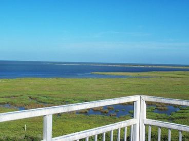 Extensive salt marshes occur along the bays at Aransas National Wildlife Refuge on the Texas coast. The refuge is well-known for providing important wetland habitat for the endangered Whooping Crane.
Water Quality Downstream
During rainstorms, some of the precipitation travels along the ground surface and into local streams and rivers. As this water travels over land, it picks up nutrients, sediment, and contaminants from agricultural and urbanized landscapes. The water in the streams and rivers of Oklahoma eventually empty into the Mississippi River, which subsequently has an outlet at the Gulf of Mexico.
Oklahoma wetlands, especially those adjacent to rivers, have the capacity to act as filtering systems and improve water quality downstream. Wetland buffers along streams have been shown to reduce nutrient input by as much as 90%. Unfortunately, in the Mississippi River watershed, where many wetlands have been lost to development, large amounts of nitrogen and phosphorus now reach the Gulf Coast waters. Excessive nutrients stimulate massive algal growth, which then decomposes and uses up all of the oxygen needed to support fish and marine life. These low-oxygen areas are known as "dead zones", and have killed large numbers of fish, shrimp, crabs, and other marine life.
The Mouth of the Mississippi is known for having persistent and reoccurring dead zones due to the high volume of runoff from agricultural lands and urbanized areas within the drainage basin. According to the National Oceanic and Atmospheric Administration (NOAA), the Gulf of Mexico dead zone in 2017 measured approximately 8,800 square miles and was the largest on record since recordings began in 1985.
The implementation of best management practices on the landscape (e.g., no-till farming, the use of cover crops, and reducing the application of fertilizer) in conjunction with the protection and restoration of riverine wetlands and riparian buffers can significantly reduce the amount of nutrients, sediments, and pollutants reaching downstream waters. For more information, see the OCC Soil Health Program
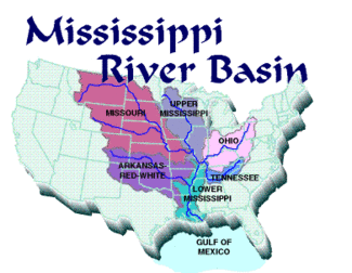 This photo depicts the Mississippi River drainage basin, which drains 31 states and 2 Canadian provinces. Streams flow out of Oklahoma and ultimately reach the Gulf of Mexico at the "Mouth of the Mississippi".
Photo credit: NOAA
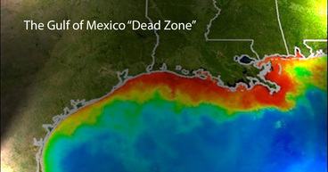 This image shows the extent of the dead zone in the Gulf of Mexico. The red and orange colors represent areas with the highest phytoplankton (algae) concentrations.
Photo credit: NASA
Depressional Wetlands
Most depressional wetlands occur in distinct basins, which might lead to the impression that these ecosystems are disconnected. However, depressional wetlands across the country can be connected by the movement of animals and groundwater. In fact, Oklahoma wetlands rely on depressional wetlands throughout the central United States including the prairie pothole wetlands in the Upper Midwest, and playa wetlands in the Texas Panhandle.
Prairie Pothole Region
The vast majority of waterfowl that we enjoy here in
Oklahoma for recreation and hunting are dependent on wetlands in the North, particularly the Prairie Pothole Region, for nesting grounds. The Prairie Pothole Region is known as one of the richest wetland systems on earth. The region consists of millions of depressional wetlands known as "potholes" that span across five states: Iowa, Minnesota, North Dakota, South Dakota, and Montana.
This wetland complex, along with the surrounding grasslands, provides critical habitat for nesting waterfowl, shorebirds, and other grassland birds. In fact, an estimated one-third of North America's waterfowl population nests within the region, including mallards, pintails, gadwall, blue-winged teal, shovelers, canvasbacks, and redheads. Just as these species are dependent on northern wetlands for nesting, they rely on wetlands in the Central Great Plains, including Oklahoma, for migration and overwintering habitat. In order for migratory bird populations to survive, they depend on the presence, as well as the quality of wetlands in both regions.
 Photo: Prairie Pothole Region, U.S. Fish & Wildlife Service
 This photo, captured in North Dakota, shows the large numbers of ducks and geese that rely on wetlands in the Prairie Pothole Region.
Photo credit: U.S. Fish & Wildlife Service
Playa Wetlands
Wetlands in the Oklahoma Panhandle are part of a larger complex of playa wetlands, which extends to the Texas panhandle, New Mexico, Colorado, Kansas, and Nebraska. Playa wetlands, also called playa lakes, typically fill with water after spring rainstorms. The water stored in playas is critical for many species, that would otherwise have little to no access to water. Playas provide important habitat for millions of waterfowl and shorebirds that use these wetlands during migration, or overwinter in the Southern High Plains. Playas also provide habitat for many species of amphibians, reptiles, and other mammals. Populations of these animals rely on aggregations of playa wetlands, so they can move between individual wetlands.
Playa wetlands are connected to the underlying Ogallala Aquifer, which spans eight states and more than 170,000 square miles. Playas are the primary source of recharge for the aquifer, which serves as an important resource for drinking water and irrigation. Studies have shown that playas filter and recharge as much as 95% of the water collected in the southern portion of the aquifer. Additionally, some playas are even filled from groundwater. This means that the water that drains into one playa, may also be a source for additional wetlands.
 This map overlays playas onto the Ogallala Aquifer. Map Credit: Playa Lakes Joint Venture
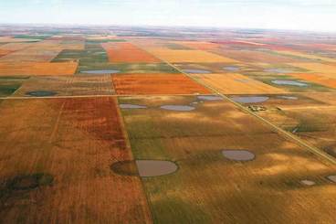 Aerial image of a network of playa wetlands in Kansas. Photo credit: Kansas Geological Survey
|