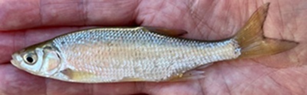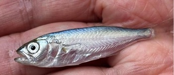
Photo of golden shiner courtesy of Tom Lake
In this issue:
With some drier days, typical of the season, measurable salinity has slowly been creeping up the river luring more brackish-water and marine fish species. At the same time, schools of young-of-year fishes have been very slowly moving downriver from points north headed ultimately to the sea.
There is an adage that the Hudson River flows both ways. Many interpret that to be a reference to the tides. Mohican people have a word for it, Mahicannituk. There is a biological example as well: Fishes migrating in from the sea to spawn, and their progeny heading the other way back to the sea.
6/11 – Garrison, HRM 51: With an evening thunderstorm looming, my wife hastily dashed out to our back patio to retrieve an item from a wooden chest. As she opened the chest, the heavy lid slipped from her hands and clattered to the ground.
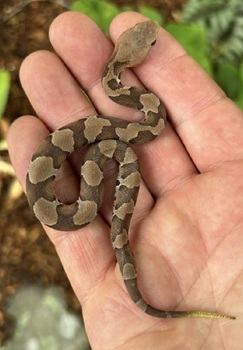
The next morning, we discovered a dead northern copperhead (Agkistrodon contortrix) where the lid had fallen, its head apparently crushed by the impact. It was a juvenile, live-birthed the previous year. It still retained a bright yellow-tipped tail used as a caudal lure for prey, a trait lost as the snake matures. Copperheads are exquisite creatures, so well camouflaged that they literally disappear into the leafy forest floor. Their adaptations for prey acquisition include two forward-facing infrared-sensing pit organs, needle sharp fangs for delivering venom, and a highly refined ability to scent trail envenomated [poisoned by venom] prey.
As a trainer for the NYSDEC venomous snake response program, I know the odds of an incidental bite are exceeding low. Still, this discovery was a bit disconcerting given the average litter size is around seven. Others must be close by. As avid gardeners, we will have to look out for more than poison ivy.
- Ed McGowan
If you see a copperhead or rattlesnake in your yard, contact the Regional DEC Wildlife Office at wildlife.r3@dec.ny.gov, or call 845-256-3098, for information and assistance with relocation of the animal by NYS DEC licensed individuals.
- Lisa Masi, NYSDEC Wildlife Biologist
Photo of Northern copperhead courtesy of Ed McGowan
6/8 – Manhattan, HRM 1-2: Our Hudson River Park’s River Project staff and interns checked our research gear (pots and traps) that we deploy from floating docks on the south-side of Piers 26 and 40 in Hudson River Park for our ongoing Fish Ecology Survey. Today our gear collected six adult blackfish (260-370 mm) and three adult oyster toadfish (216-270 mm).
- Siddhartha Hayes, Luna Horsley, Rashel Caraballo
[Note: One-inch equals 25.4 millimeters (mm). Tom Lake]
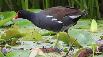
6/9 – Saratoga County, HRM 167: I came upon a couple of common gallinule (Gallinula galeata) today at the Round Lake Preserve strolling through wetland vegetation including purple loosestrife, water lily, arrow arum, and button bush.
- Katrina Van Tassel
Photo of common gallinule courtesy of Katrina Van Tassel
6/10 – Manhattan, HRM 1-2: Our Hudson River Park’s River Project staff and interns checked our research gear (pots and traps) that we deploy from floating docks on the south-side of Piers 26 and 40 in Hudson River Park for our ongoing Fish Ecology Survey. Catches remained impressively high with six more blackfish (195-380 mm), three oyster toadfish (93-200 mm), and one summer flounder (195 mm). Among invertebrate species, were several long-clawed hermit crabs.
- Toland Kister, James Laske, Maren Piersol, Lawrence Byrne, Kumarie Singh
6/11 – Town of Poughkeepsie: The three newly-fledged bald eagles at bald eagle nest NY62 were all out and demonstrating a complete at ease with their new world. A single female (with two different males, one died) has produced 36 nestlings across 26 years, only 20 of which had a nestling.
- Tom Lake
6/12 – Manhattan, HRM 1-2: Our Hudson River Park’s River Project staff and interns checked our research gear (pots and traps) that we deploy from floating docks on the south-side of Piers 26 and 40 in Hudson River Park for our ongoing Fish Ecology Survey.
Today, our gear collected six oyster toadfish (95-245 mm), two blackfish (200-210 mm), and one northern pipefish (145 mm). Invertebrates included oyster drills, mud crabs, grass shrimp, mud dog whelks, marine isopods, and marine leeches.
- Toland Kister, Beryl Kahn, Jack Nelson, Arden Egerton
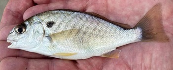
6/13 – Piermont Pier, HRM 25: Our Lamont Doherty’s Hudson River Field Station research and education staff enjoyed a sunny Science Saturday with participants of all ages jumping into the water to seine with us. As we pulled our last haul onto the riverbank, field station staff noticed a small silver fish in the net: It was our first spot, a small drum (Leiostomus xanthurus), of the season. We also caught some of our more usual species including striped bass, Atlantic silverside, Atlantic menhaden, blue crabs, moon jellyfish, summer flounder, and a whopping 152 shore shrimp, 42 of which were gravid [carrying eggs]. The salinity was 6.0 parts-per-thousand.
- Sarah Ortiz
Photo of spot courtesy of Tom Lake
6/14 – Saugerties, HRM 102: The Hudson River Almanac, since 2018, with assistance from countless contributors has chronicled the extraordinary story of a harbor seal (Phoca vitulina) and its attachment to a freshwater tributary 109 miles from the sea. What follows is his story — Part 1 (2018-2022) — as best as we know it.
- April 5, 2018, a young harbor seal was rescued from Lower Goose Island, Harpswell, Maine. The circumstances surrounding its abandonment were unclear, although marine mammal experts from NOAA suspected the pup may have been a premature birth.
- The young harbor seal was transported to the Mystic (Connecticut) Aquarium Animal Rescue Program where it was determined that the seal was a male. Long term medical rehabilitation followed. At its conclusion, a satellite tracker, as well as a white tag (2-4-6) was applied on its rear flipper before the seal was released as a yearling (one-year-old), at Charlestown, Rhode Island, on January 17, 2019.
- Once released, the satellite tag imagery revealed that the seal traveled 81 miles up the Connecticut River to the Holyoke Dam, the first impassable barrier. The seal then reversed its course exiting downriver into Fishers Island Sound then across Long Island Sound to the Peconic Bays before going offshore. The seal then traveled down along the south shore of Long Island into the New York Bight and eventually into the Hudson River estuary.
- Heading upstream into freshwater on August 5, 2019, he found a home in Esopus Creek at Saugerties, Hudson river mile 102 (109 miles from the sea). From that day on, he has been faithfully monitored by Patrick Landewe, Saugerties Lighthouse Keeper.
- For the balance of 2019 into winter, harbor seal tagged 2-4-6 made almost daily appearances. When full winter set in and the creek iced over, he left for the loose and moving ice floes of the main river. Following late-winter ice-out he was back for spring 2020.
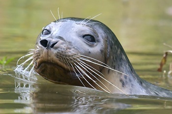 |
Photo of harbor seal courtesy of Michael Kalin
- On May 2020, however, the seal mysteriously disappeared. On June 17, 44 days later, Maxine Montello, Rescue Program Director with the New York Marine Rescue Center, told us she had picked up a male harbor seal with a tag number 2-4-6 on Atlantic Beach, Nassau County, Long Island, 140 miles seaward of Saugerties. The seal was getting a lot of attention from the public, and had some superficial scaring on his body, so it was decided it would be in the best interest of the seal to give him some rehabilitation.
- He was transported to the Marine Rescue center in Riverhead, Suffolk County Long Island. He stayed at the rescue center for two months and was treated for an infection as well as seal pox (a cutaneous skin) a condition caused by a Parapoxvirus. On August 14, after being given a second blue tag number 1-0-5, he was released in Hampton Bays, Suffolk County, Long Island.
- From there he began a 210-mile journey from Hampton Bays to New York Harbor and then upriver to Saugerties and Esopus Creek arriving by autumn, where Lighthouse Keeper Patrick Landewe welcomed him back. Except for a few short trips within the estuary, and to avoid winter ice in the Esopus, the seal hung around the mouth of the creek and the Saugerties Lighthouse through the end of 2020, and all of 2021.
- Tom Lake, Patrick Landewe
- Next week: Part 2 (2022-2026).
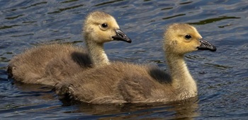
6/14 – Orange County, HRM 41: I photographed a couple of Canada geese goslings today at the 62-acre Edgar A. Mearns 6½ Station Road Marshlands Sanctuary in Goshen.
- Matt Zeitler
Photo of Canada geese goslings courtesy of Matt Zeitler
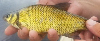
6/15 – Hudson River Watershed: Fish-of-the-Week for Week 371 is the golden shiner (Notemigonus crysoleucas) number 52 (of 240), on our Hudson River Watershed List of Fishes. If you would like a copy of our list, e-mail: trlake7@aol.com.
Golden shiner is a member of the True Minnows family of fishes (Leuciscidae), the largest family of fishes (30) documented for our watershed. As a result of recent taxonomic fine-tuning, five former members of Cyprinidae (Carps & Minnows) have been reclassified as Acheilognathidae (Bitterlings), Xenocyprididae (East Asian Minnows), with three species remaining in Cyprinidae.
Although golden shiners can get to be a foot-long, they are more commonly found at half that size. They have long been a prime commercially-sold live-bait species for anglers. In many quarters, especially in the wild, its reputation has been one of a “bait-stealer,” particularly to anglers targeting gamefish. They are largely omnivorous, feeding primarily on zooplankton, insects, mollusks, and filamentous algae.
As a native species, their place in the greater Hudson River Watershed is known from the prehistory of the native Haudenosaunee and Mohican people. One of my favorite tales comes from historic times with Dr. Caleb Rea, regimental surgeon for the English garrison at the always contentious Fort William Henry (1755-1757). Dr. Rea, when not practicing surgery on soldiers, wrote in his journal of rod and reel fishing and “roach” being caught by himself and other anglers in Lake George (Warren County). While roach was a common name for “look-alike” fishes in England, Europeans had never seen a genuine golden shiner. Historians widely surmise that these roach were golden shiners (The Journal of Dr. Caleb Rea, Essex Institute,1881).
Golden shiners favor lakes, ponds, and creeks where they can tolerate low dissolved oxygen levels, high turbidity, and high water temperatures. That adaptability has resulted in them being one of the widest raging fish species across North America. They are native to the Atlantic and Gulf Slope drainages from Nova Scotia in Canada to southern Texas, and from the Great Lakes to western Canada. In the Hudson River watershed, the golden shiner is classified as “a native freshwater fish.”
The Type Site for the golden shiner, where it was first described to science by Samuel Latham Mitchill in 1814, is “NY.” That is very inexact and literally translates to somewhere in New York State, including the Hudson River Watershed.
Mitchell’s original description, from On the Fishes of New York (1814), notes that “Cyprinus crysoleucas [Notemigonus crysoleucas] lives in freshwater ponds; their head small and smooth; being rather depressed on the upper side; mouth small, even and toothless; eyes large in proportion to the head; body deep in proportion to its length; with shining white scales; eyes and gill-covers golden, with a tinge of the same along the belly; lateral line bending downward to correspond with the curve of the abdomen; pectoral and ventral fins, especially the later, yellowish brown; tail forked; belly whitish, with ruddy rays.”
- Tom Lake
Photo of golden shiner courtesy of Cornell DNR
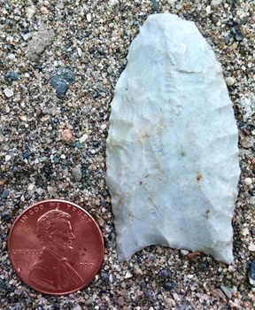
6/16 – Wallkill River, HRM 77: As I walked along the edge of a fallow cornfield twenty-seven years ago today (1999), and twenty feet from the Wallkill River, I listened to the exhilarating “witchity-witchity-witchity” song of the common yellowthroat. I was on an archaeology reconnaissance, a site assessment, so my eyes were following the contours of the harrowed soil when I spotted the thin edge of a small piece of gray “worked” chert (worked = altered by human hands). The chert (stone) was a hard, fine-grained sedimentary cryptocrystalline rock protruding from a crack in the dry earth.
It was an “Indian” (Indigenous) artifact, a stone projectile point (47 x 25 mm) that had eroded from the soil with the spring rains. I had come upon a very old spear point that stylistically-dates to about 12,900 calendar years ago (years before present). The implications reconfirmed our sense of the incredible time-depth of our Hudson River Valley.
Archaeologists have classified this stone artifact as a Barnes-type fluted spear point, a tool that predated “arrowheads” by nearly ten thousand years (Meltzer 1999, Funk 1999, Ellis 2004). The Barnes Point’s Type Site is Barnes Creek, Michigan, where it was first named and identified to science by William Roosa in 1963, as well as Parkhill, Ontario (Wright and Roosa,1966). Fluted points are a temporally-diagnostic tool used by indigenous people, often referred to as Paleoindian, the first of our species to arrive in the Americas during the Late Pleistocene period.
The geology and morphology of this point includes the raw stone itself, the lithic, plucked from the earth by a slowly passing glacier eons ago, or more recently quarried from exposed bedrock. Indigenous stone quarries, of which the Hudson Valley had many, were the cathedrals of the day, sacred places where the subsistence of Stone Age life was extracted.
This Barnes point was fashioned from a very light gray chert (Munsell value N8), a high quality lithic. The chert was a Big Springs member of the Epler Formation and was extracted from a bedrock quarry in Sussex County, NJ. The spear point had been reworked during its useable lifetime and possibly heat-treated to strengthen its edges (Munsell Soil Color Charts, 1998).
There was a triangular spatial, social, and cultural connection to this artifact: The point style originated in southwestern Ontario, Canada. From Ontario, hunter-gatherer bands carried the style south, then east, through the Mohawk River Valley, then south again along the Hudson River stopping at stone quarries along the way, following game herds into northern New Jersey. An important element of this three-cornered route was the role of the Wallkill River Valley as a seasonal passageway, a conduit.
Archaeologists are commonly thought of as people who grew up but never lost their sense of wonder and imagination. Quite understandable. As we walk the fields and forest of the Hudson Valley, it is difficult to avoid feeling the sense of antiquity and magic of the land.
- Tom Lake
Photo of Barnes Point courtesy of Tom Lake
6/16 – Yonkers, HRM 18: Our research and education team at the Sarah Lawrence Center for the Urban River at Beczak made eight high tide hauls of our seine today resulting in a varied catch of fish and invertebrates. Blue crab was high count with six (to 110 mm). Among fishes were white perch (140-205 mm) and bay anchovy. The water temperature was 71 degrees Fahrenheit, salinity was 10.9 parts-per-thousand, and dissolved oxygen (DO) was 8.9 parts-per-million.
- Jason Muller, Liana Napier, Lyla Harrison duBoulay, James Cook, Maya Rodriguez, Katie Lamb, Logan Roman
[Crab measurements (size) are calculated in millimeters (mm) point-to-point across their carapace. Tom Lake]
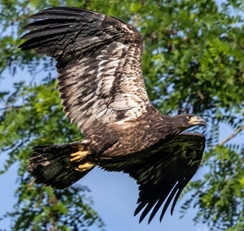
6/17 – Town of Poughkeepsie: All three fledglings from bald eagle nest NY62 were finally out, in view, flying around. Collectively, three fish, including an American eel, were brought in from the river.
- Bob Rightmyer
Photo of bald eagle courtesy of Bob Rightmyer
6/17 – Little Stony Point Preserve, HRM 55: The day was gorgeous but that is always just half of the equation. Then there is the tide. We missed slack water and had to go at half-flood with a ripping tide eliminating seine hauls against the current. The water was a comfortable 73 degrees Fahrenheit and there was some salt — 2.0 parts-per-thousand — for the first time this season. The salt made it less surprising when young-of-year bluefish (62-63 mm) showed up in the net. Some of the first young-of-year alewives (53-54 mm) and striped bass (22-26 mm) were also there. Staying with fish, there was something we see every year in late spring, a second cohort of striped bass (110-114), seemingly too large for young-of-year, and maybe too small for yearlings. Male blue crabs (40 mm) completed the catch.
- Seth Dinitz, Tom Lake, Ellie Dinitz
[On the trail back up the hill from the beach we passed two male Baltimore orioles. Even in the thickening green of the forest, we could see the blaze orange. When I see them, fleetingly like this, I remember Aldo Leopold’s classic observation “The flash of an oriole is like a burst of fire!” Tom Lake]
Photo of bluefish courtesy of Tom Lake
6/17 – Yonkers, HRM18: Our research and education team at the Sarah Lawrence Center for the Urban River at Beczak made nine high-tide seine hauls today and discovered that the bay anchovy (22 young-of-year) run was still ongoing. Other young-of-year fishes included bluefish (55 mm) and Atlantic menhaden.
The water temperature had risen to 74 degrees Fahrenheit, salinity was 11.0 parts-per-thousand, and dissolved oxygen (DO) was 8.5 parts-per-million.
- Jason Muller, Liana Napier, Lyla Harrison duBoulay, James Cook, Maya Rodriguez, Katie Lamb, Logan Roman, Davidson Montiero
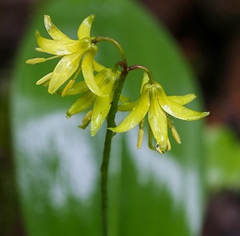
6/18 – Hudson River Watershed: Clintonia (Clintonia borealis), a member of the Lily family, is a plant you’re not likely to soon forget once you’ve encountered it, due to its thick, shiny, oval leaves and bell-like yellow flowers. This boreal species requires the cool temperatures of northern region of the watershed. It has leaves that closely resemble those of pink lady’s slipper, except clintonia leaves lack the deep parallel veins of pink lady’s slipper leaves. Equally as distinctive as the leaves and flowers are the spherical fruits of clintonia. Their bright blue color is responsible for this plant’s other common name, blue bead-lily.
- Mary Holland
Photo of clintonia courtesy of Mary Holland
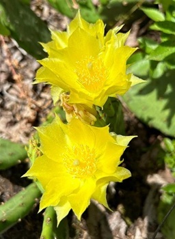
6/19 – Hudson River Watershed: I took the holiday off today (Juneteenth) and went for a hike. Of the many examples of wildlife I came upon, the Eastern Prickly Pear was the most impressive.
- Jack Hole
The eastern prickly pear (Opuntia humifusa) is found from southwestern Ontario, where it is a threatened species, south to Florida and west to Texas. The eastern prickly pear, the only native cactus in northeast North America.
Prickly pear is protected under the New York State Protected Native Plants Program where they are classified as an “exploitable vulnerable native plant.” In the lower Hudson Valley, the prickly pear exists in a few locations, its presence tenuous at best. It requires sunny, dry areas with sandy soils and a south-southwest exposure, usually marginal habitat for other plants. In Westchester County there is a hill called Prickly Pear. Habitat loss due to development over the last few decades destroyed the considerable number of cacti that once grew there.
A hard-and-fast rule with Hudson River Almanac entries is that the location of protected and sensitive wildlife is intentionally left vague. Usually, it is done to protect the subject from the all-to-often unbridled zeal of collectors. Among the most common examples are choice mushrooms (foragers would rather give you their wallet than disclose a location where prime mushrooms were appearing), stands of orchids, rattlesnake dens, dunes of snowy owls, vulnerable nests, especially bald eagles, osprey, and shorebirds, archaeological investigations, and fields of prickly pear. Tom Lake]
Photo of Eastern prickly pear courtesy of Jack Hoye
Science Saturday at Norrie Point Environmental Center
Join us for our monthly Science Saturday programs and explore Norrie Point. Check out our series by visiting the Hudson River website. Events are free and open to the public. Registration is not required. All programs meet at the Norrie Point Environmental Center, 256 Norrie Point Way, Staatsburg NY, 12580. Dress for the weather and being outside! Otherwise, no special equipment is needed.
Saturday June 27, 10:00am to 12:00pm. Join DEC educators to learn about local plants, and how to ID common species in our area. We will meet at Mills Mansion Staatsburg State Historic Site. Park at the carriage barn (signs will be posted) to meet DEC Staff. Please note that this program will require walking on rocky steps and uneven terrain. The hike will be 1 hour. More information (PDF).
Snapshot NY
The NYSDEC, in collaboration with the New York Cooperative Fish and Wildlife Research Unit at Cornell University, has launched Snapshot NY, a citizen science program that allows the public to participate in wildlife monitoring through the deployment of trail cameras. The project will help improve the way DEC monitors and manages more than a dozen wildlife species. For more information on Snapshot NY and how to participate, visit the Snapshot NY website.
Hudson River Lesson Plans
Explore our collection of Hudson River lesson plans, videos and online activities to support hands on investigations of the Hudson River in your classroom.
Hudson River: Striped Bass Cooperative Angler Program
You can share your fishing trip information and help biologists understand and manage our Hudson River striped bass fishery.
Here’s how it works: Fill out a logbook provided by us whenever you fish on the Hudson River (by boat or from shore). You can also use our survey123 app and record your trips using a smart phone or computer.
Record general location, time, gear used, what you caught (or if you didn’t catch anything) and return the logbook when you are done fishing for the season. You’ll receive an annual newsletter summarizing the information in addition to the latest news regarding regulations and the river. Whether you catch-and-release or take home a keeper, you can be part of the Cooperative Angler Program. Online logbook instructions (PDF).
Join today by contacting: hudsonangler@dec.ny.gov
- Jessica Best
Hudson River Miles
The Hudson is measured north from Hudson River Mile 0 at the Battery at the southern tip of Manhattan. The George Washington Bridge is at HRM 12, the Tappan Zee 28, Bear Mountain 47, Beacon-Newburgh 62, Mid-Hudson 75, Kingston-Rhinecliff 95, Rip Van Winkle 114, and the Federal Dam at Troy, the head of tidewater, at 153. The tidal section of the Hudson constitutes a bit less than half the total distance—315 miles—from Lake Tear of the Clouds to the Battery. Entries from points east and west in the watershed reference the corresponding river mile on the mainstem.
To Contribute Your Observations
The Hudson River Almanac is compiled and edited by Tom Lake and emailed weekly by DEC's Hudson River Estuary Program. Share your observations by e-mailing them to trlake7@aol.com.
Was this Newsletter Forwarded to You?
Subscribe today to DEC Delivers Hudson River Almanac topic for weekly natural history journal that covers the Hudson from the High Peaks of the Adirondacks to New York Harbor.
Helpful Resources
National Oceanic and Atmospheric Administration online tide and tidal current predictions are invaluable when planning Hudson River field trips. For real-time information on Hudson River tides, weather, and water conditions from sixteen monitoring stations, visit the Hudson River Environmental Conditions Observing System website.
DEC's Smartphone app for iPhone and Android is now available at New York Fishing, Hunting, and Wildlife App.
|