This bulletin provides only the most recent notices. Check the Adirondack Backcountry webpages for more detailed information on access, outdoor recreation infrastructure, and conditions.
Emergency Situations: If you get lost or injured; keep calm and stay put. If you have cell service, call 911 or the DEC Forest Ranger Emergency Dispatch, 833-NYS-RANGERS.
Welcome to the Adirondacks. The Welcome to the Adirondacks webpage provides information about the Forest Preserve, conservation easement lands, outdoor recreation, and Leave No Trace™.
Love Our New York Lands: All New Yorkers and visitors should be able to access, enjoy, and feel welcome on state lands. While enjoying these shared spaces, be respectful of other visitors. Share trails, treat people with kindness, and leave things as you found them for others to enjoy. All of us have a responsibility to protect state lands for future generations. Learn more about how you can Love Our New York Lands.
In this issue:
The following are only the most recent notices pertaining to public lands in the Adirondacks. Please check the Adirondack Backcountry webpages for a full list of notices, including seasonal road statuses, rock climbing closures, specific trail conditions, and other pertinent information.
Follow @NYSDECAlerts on X for updates about DEC-managed lands across New York State! The @NYSDECAlerts X feed provides real-time info on the most crowded places, especially when those places and parking areas are at capacity.
NEW THIS WEEK
If you notice any damage or hazardous areas not listed below, please report to info.r5@dec.ny.gov.
High Peaks
-
Weekly Lake Colden Snow Report: As of Wednesday, 12/18, snow depths were recorded to be 35cm (14in) at the stake.
Northwestern
-
Grass River Wild Forest: An ongoing timber harvest necessitates the temporary closure of Snowmobile Trail 740 on the Tooley Pond Conservation Easement, which overlays the Spruce Mountain Road from where it intersects the Tooley Pond Road to where it intersects with the Beech Hill Road. The S81 snowmobile trail, overlaying the Beech Hill Road, provides an alternate route around this closure. There are also temporary closures to sections of the S88, S88A, and C8 snowmobile trails on the Grass River, Cranberry Forest, and Seveys Conservation Easements. For the latest updates, please check the New York State Snowmobile Association’s website before heading out. Lastly, as of Sunday, December 15, public access to the Grass River Conservation Easement is open for the season, and public non-motorized access on trails, roads, and overland on the Cranberry Forest Conservation Easement is open for the season.
East Central
-
Camp Santanoni Historic Area: Newcomb Lake Road to Camp Santanoni is now over-the-snow travel only (ski/snowshoe).
-
Essex Chain Lakes Complex: Seasonal gates on Chain Lakes Road South are closed for the winter season.
Eastern
-
Lake George Wild Forest: All MAPPWD routes in Lake George Wild Forest are closed for the season, and Dacy Clearing Road (beyond Hogtown Parking Lot) is closed for the season.
LAST WEEK
-
Weekly Lake Colden Snow Report: As of Thursday, 12/12, snow depths were recorded to be 46cm (18in) at the stake.
-
Boreas Pond Tract: Gulf Brook Road, access to Boreas Ponds, is closed and gated for the season.
-
High Peaks Wilderness: Meadows Lane (access to South Meadows) has been closed for the winter. Please plan accordingly for access to the South Meadow, Klondike, and other trails. If parking in the lot at the junction with Meadows Lane and Adirondack Loj Rd, please DO NOT block the gap between the barriers.
-
Santa Clara Conservation Easement Tract: All public access roads on this easement are closed. The roads will reopen after they have dried out in the spring.
-
Saranac Lakes Wild Forest: The seasonal use roads are closed. The roads will reopen after they have dried out in the spring. The roads closed are Connery Pond Road, Little Clear/Little Green Road, and Saint Germain Pond Road. Users can use the parking lot at the end of Station Road to access the Adirondack Rail Trail.
-
Saint Regis Canoe Area: The gate to access Saint Germain Pond is closed for the winter season.
-
Wilmington Wild Forest: The Cooper Kiln Pond lean-to has been dismantled in preparation for new lean-to construction. This page will be updated when a new lean-to is in place there.
-
William C. Whitney Wilderness & Round Lake Wilderness: Lake Lila Road is closed. It will reopen after the road has dried out in the spring.
-
Blue Mountain Wild Forest: Township 19 Conservation Easement - O’Neil Flow Road is closed for the winter season.
-
Blue Ridge Wilderness and Wakely Mountain Primitive Area: Cedar River Road is closed for the winter season. There is no motor vehicle access to Cedar River Flow/ Wakely Dam area. This includes the Wakely Mountain Fire Tower trail.
-
Moose River Plains Complex: The Moose River Plains entrance gates are open for snowmobile season. Passenger vehicle access is restricted.
-
West Canada Lakes Wilderness: Perkins Clearance Road, Old Military Road, and Jessup River Road are closed for the winter.Mason Lake, Pillsbury Lake Trailhead, and Spruce Lake Trailhead are no longer accessible via motor vehicle.
-
Jessup River Wild Forest: Perkins Clearance Road, Old Military Road, and Jessup River Road are closed for the winter. Mason Lake, Pillsbury Lake Trailhead, and Spruce Lake Trailhead are no longer accessible via motor vehicle.
-
Perkins Clearing/Speculator Tree Farm Conservation Easement Tracts: Perkins Clearance Road, Mud Lake Road, Old Military Road, Jessup River Road, and all roads within Speculator Tree Farm including Elm Lake Road are now closed for the winter. Mason Lake, Pillsbury Lake Trailhead, and Spruce Lake Trailhead are no longer accessible via motor vehicle.
-
Ferris Lake Wild Forest: Powley Road which provides access to Ferris Lake Wild Forest is closed for the season.
-
Lake Desolation Conservation Easement: The road to Archer Vly is closed to motor vehicles for the snowmobile season. Please park across the road entrance.
-
Silver Lake Wilderness: West River Road, which provides access to the Whitehouse Trailhead of the Northville Placid Trail, is closed for the season.
 |
Fire Danger: Check the fire rating map for daily updates.
Sunrise/Sunset: Sunrise = 7:27 a.m.; Sunset = 4:19 p.m. Pack at least one headlamp (two headlamps recommended) even if you expect to finish your activity before sunset. Phone batteries drain quickly and are discouraged.
Water Crossings: Water levels are slightly high for this time of year throughout the Adirondack region. Expect water levels to rise with new rainfall. Check the USGS Current Water Data for New York for stream flow of selected waters. (Personal Flotation Devices (PFDs aka lifejackets) are strongly recommended if spending time on the water.)
Temperatures: These are forecast temperatures for base elevations throughout the region.
Weekend temperatures in the region are expected to produce highs in the mid-20s, and lows in the negative single digits. It will get progressively colder from Friday through Sunday, but the chance of snow will decrease.
Check the National Weather Service’s Mountain Point Forecast for more accurate forecasts at elevation on or near your intended route.
Reminder: These forecasts are for low elevations. Anticipate losing 5 degrees Fahrenheit for every 1,000 feet of elevation gain.
Even with sunny skies, inclement weather is always a possibility and can change very quickly. Remember – hypothermia is always a risk in wet conditions, even when it feels warm outside. Be prepared with extra dry layers and keep an eye on the weather.
Conditions: Unpredictable storms and general winter weather can create unexpectedly hazardous conditions. Visitors should be prepared with proper clothing and equipment for snow, ice, and cold to ensure a safe winter experience. Snow depths range greatly throughout the Adirondacks, with the deepest snow at higher elevations in the High Peaks region and other mountains over 3,000 feet. Lower elevation trails have mixed conditions of snow, ice, slush, and mud.
Check the Weather: Check the forecast for your destination and pack and plan accordingly. Check the National Weather Service Northern Adirondacks and Southern Adirondacks Mountain Point Forecasts for select summit forecasts. Check both daytime and nighttime temperatures and remember that temperatures will drop as you gain elevation.
Snowmobiles: Visitors are advised to plan ahead and check local club, county, and State webpages and resources, including the NYSSA Snowmobile web map, for up-to-date snowmobile trail information.
Check the Air Quality Index (AQI) Forecast: If the AQI is forecast to exceed 100, DEC and the New York State Department of Health (DOH) will issue an Air Quality Health Advisory with precautionary recommendations for affected areas. View DEC’s current AQI forecasts and real-time air pollution data from DEC’s monitoring network.
Visit the main Adirondack Backcountry page for more trip-planning resources.
Seasonal Road Closures: Read DEC’s Adirondack Backcountry Information page for specific road conditions and information.
Adirondack Rail Trail: The Adirondack Rail Trail is a multi-use trail allowing for various types of recreational activities. To ensure safety for all while sharing the trail, all users should travel on the right side of the trail unless passing others. Groups should move in single file on the right when other users are passing. Cyclists should pass on the left and inform others prior to and while passing. Snowmobilers should pass slowly on the left and travel in single file, paying extra attention to those nearby at turns, intersections, and popular/congested areas. Lastly, pet owners must ensure that all waste is picked up and dogs are kept on leashes. For information on what sections of the trail are currently open or under construction, or what public motorized use is allowed, visit the Adirondack Rail Trail webpage.
Mount Colden Trapdike: The trapdike is considered a technical climb and not a hike. Climbers should be prepared with helmets, ropes, and climbing gear to ascend this route. Hikers looking to summit Mount Colden should do so via the hiking routes. Attempting to climb the trapdike unprepared can result in a rescue operation, serious injury, or death.
No Overnight Camping at Trailheads: Overnight camping is not permitted at trailheads or other roadside locations where a camping disc is not present. This includes individuals sleeping in cars, vans, and campers. Campers should seek out designated roadside campsites marked with a "Camp Here" disc or open campgrounds. When camping, always carry out what you carry in and dispose of trash properly. Use designated bathroom facilities, pack out human and pet waste, or dig a cat hole.
Travel: Plan on arriving at your destination early and have several back-up plans in place in case parking at your desired location is full. Check recent notices for road closure announcements.
Looking forward to a fresh start in 2025? Why not plan for something fun on New Year's Day!
The Department of Environmental Conservation, The New York State Office of Parks, Recreation and Historic Preservation (State Parks), and the Canal Corporation invite New Yorkers to kick off 2025 by participating in one of the many hikes being held at state parks, historic sites, wildlife areas, trails, and public lands across the Empire State.
All DEC walks and hikes are free, and most are family-friendly, typically ranging from one to five miles, depending on the location and conditions. View photos from 2024's event on DEC's Flickr album!
First Day Hikers on Coney Mountain, 2024
Avalanche transceivers are generally regarded as the fastest way to locate a person who is buried by an avalanche. They can both transmit a signal and search for a signal.
February, March, and January, in that order, are the most common months for avalanches. Since those months are right around the corner, get yourself the best holiday gift by investing in avalanche gear, such as an avalanche transceiver (AKA beacon), shovel, and a collapsible or ski-pole probe.
Then, make it a New Year’s resolution to learn how to you use all the avalanche gear and other 10 Essentials that you regularly pack, including practicing frequently to be proficient in using your beacon. And say hello to a New Year full of fun and safe outdoor experiences!
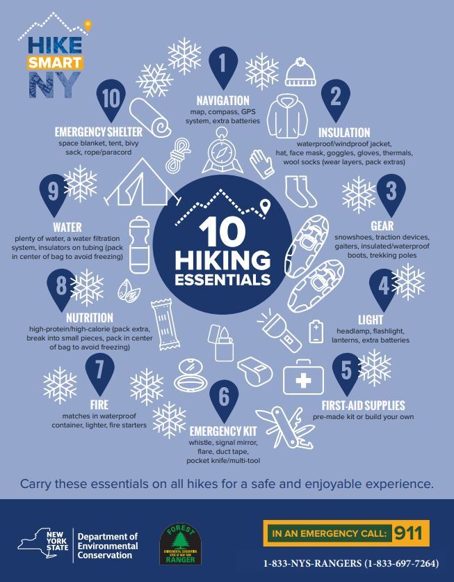
Hike Smart NY can help you prepare with a list of 10 essentials, guidance on what to wear, and tips for planning your trip with safety and sustainability in mind.
By making an effort to Leave No Trace, you’re protecting all the flora and fauna that make the Adirondacks, the Adirondacks.
The crisp scent of evergreen trees wafting through the air. Aster flowers and wild Bunchberry giving bright pops of color amidst a relaxing sea of green. Lush Pincushion Moss coating the forest floor, providing an appealingly soft contrast to the rigid, root-y trail.
Walking through the Adirondack Forest Preserve is a naturally immersive experience. And although its most iconic flora and fauna is hidden or hibernating in the winter, the snowy season still has its own beautiful blooms.
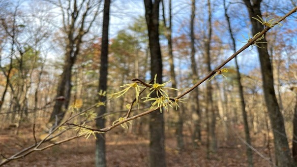
For example… witch-hazels (Hamamelis)! American witch-hazel’s bright yellow flowers can be found blooming in the forest understory in late fall and early winter. Another native species, vernal witch-hazel, blooms in late winter. While the timing might seem odd, a late bloom allows witch-hazel to take advantage of pollinators that are active in winter, like owlet moths. To survive cold conditions, the spindly flowers curl up, then unfurl again when temperatures rise. Witch-hazel also has a fascinating strategy for spreading its seeds: in fall, the plant’s seed pods burst open, sometimes springing seeds 40 feet away!
Keep our trails, and all the beautiful natural resources that make them special, safe, by being intentional about reducing impact!
Follow the Seven Principles of Leave No TraceTM to maintain minimal impact on the environment and the natural resources of the Adirondacks.
American witch-hazel flowers blooming in fall
|