|

The Montana State Reference Network has been busy gearing up for your summer needs. We continue to plan for ways to increase and improve our network. We value our users input and strive to create the most accurate spatial data network possible for the entire state of Montana.
Did you know? The Montana State Reference Network is being utilized by colleges all over the state. We recently sent a survey to our educators. Here is what they had to say about their experience with the MTSRN:
“We use MTSRN for groundwater research and also for gravimetry. Previously we had to hire a surveyor to measure elevations of our monitoring wells and staff gauges. It simplifies the surveying process and helps us get the spatial data we need much more quickly and easily.”
“Keep up the great work!”
“I would recommend the network because it is state wide.”
“I would highly recommend MTSRN to anyone needing high accuracy spatial data.”
“Increases workflow efficiency significantly.”
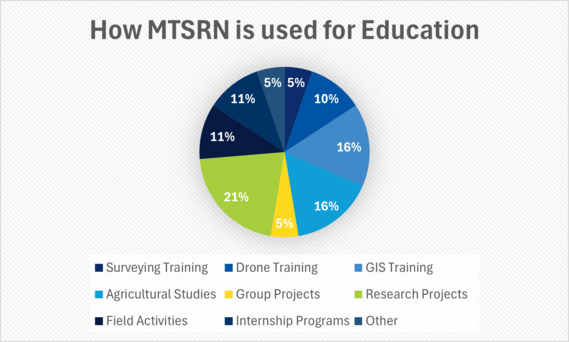
The MTSRN is being utilized for a variety of educational programs. The chart below shows the types of training being performed while working with the network.
We have been invited to the Montana State University Summer Field Days to host a booth and share more information about the network. We would love to see you there! Look for us on:
-
Wednesday, June 26th in Conrad
-
Wednesday, July 2nd in Havre
-
Thursday, August 14th in Corvallis
-
Thursday, August 28th in Bozeman
The MTSRN has hosted several informative webinars. They are available on our YouTube channel. Please enjoy this video about how to connect DJI drones to the network.
The advancement of the MTSRN has been made possible by numerous contributors who host stations, demo our network to potential subscribers, promote the network through user testimonials, and educate our next generation on the use of MTSRN. We would like to thank all of them for their support of the MTSRN.
|
|
|
|