|
Through our partnership with the Montana Natural Resources Conservation Service (NRCS), the 2023 NAIP Imagery for Montana is now available! The geospatial aerial imagery data can be downloaded as countywide mosaics in MrSID format (MG4) or accessed through a web service. The Montana Spatial Data Infrastructure (MSDI) Imagery Framework layer relies solely on the statewide imagery products produced by the US Department of Agriculture’s (USDA) National Agricultural Imagery Program (NAIP).
Full statewide coverage was not attained for the 2023 NAIP imagery collection. Eighteen (18) counties do not have complete coverage: Beaverhead, Broadwater, Cascade, Flathead, Gallatin, Glacier, Jefferson, Judith Basin, Lake, Lewis and Clark, Lincoln, Madison, Meagher, Missoula, Park, Powell, Stillwater, Sweet Grass, and Teton.
A map with the 2023 collection can be viewed at: https://ftpgeoinfo.msl.mt.gov/Data/Spatial/MSDI/Imagery/2023_NAIP/NAIP2023Collection.pdf
The 2023 NAIP web service and county mosaics will be updated with the 2024 imagery as soon as it becomes available.
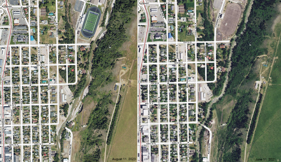
View a comparison of the 2023 and 2021 NAIP products in the images below.
Thank you to the Montana USDA Natural Resources Conservation Service, their partnership ensured the NAIP 2023 is made available in a variety of formats for Montanans!
- Explore & Download County Mosaics:
- ArcGIS REST Services Directory:
- View and explore Montana statewide imagery collections in the Montana Air Photo Browser web application:
- Order Statewide Aerial Photos or in a TIFF format:
Comparison of the 2023 NAIP (left) and 2021 NAIP (right) showing a bridge that washed out, the new path of Rock Creek, and the sand/gravel bars formed after the 2022 flooding in Red Lodge, Montana. View the area in the Montana Air Photo Browser.
Please visit the MSDI Imagery page for more information on the imagery products and services available for the state of Montana:
https://msl.mt.gov/geoinfo/msdi/orthoimagery.
|