
Montana Geo-Enabled Elections &
Redistricting Update
The new Montana Legislative Districts were adopted February 22, 2023. For more information visit: https://mtredistricting.gov/
Resources for Redistricting including an Interactive Map, Data Layers, Reports, and maps by county are now available on the Geo-Enabled Elections Hub in the new section for Redistricting:
https://geoenabled-elections-montana.hub.arcgis.com/pages/redistricting
The Montana State Library has made these resources available for download. They will be added to the Esri Managed Web Services by the end of the month.
We have done a preliminary analysis of the Voting Precincts with the new House and Senate districts, along with the 2020 Total Population and 18 and Older Population.
The page includes the following resources listed below.
Please let us know if there is anything else you need right now. Contact the Geo-Enabled Elections Team at: GeoenabledElections@mt.gov
An analysis of the County Commissioners with the 2020 Total Population number analysis will be coming soon for all counties for which we have maps. We do not currently have maps of the county commissioner districts for Treasure, Golden Valley, and Wheatland counties.
Thank you,
Meghan Burns, MSDI Administrative Boundary Steward | GIS Analyst
Montana State Library
mburns2@mt.gov
406.603.0216
Resources for Redistricting
Interactive Web Map
Montana Legislative Districts for Redistricting: This map includes the final Montana Legislative Districts, the various 2020 Census data layers including the 2020 Census Lines and 2020 Census Blocks that make up each district, the current MSDI Administrative Boundary layers, and the MSDI Structures and Addresses. Additionally, there is a Voting Precinct Analysis layer with the newly adopted House and Senate Districts with the 2020 Total Population and 2020 18 and Older Population and whether the precinct needs to be reviewed.
Voting Precinct Analysis
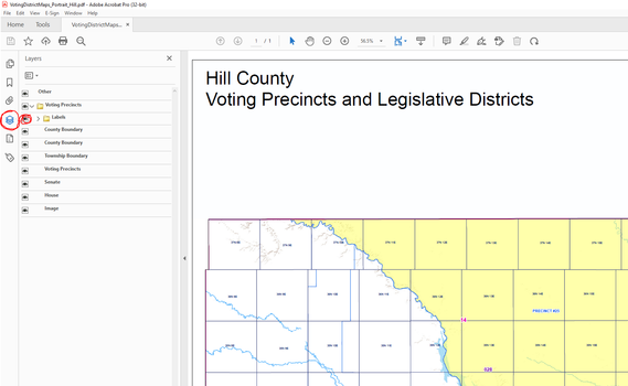
Note: the County PDF Maps are slightly interactive in Adobe.
On the left click on the Layers Button to turn on/off the districts and labels:
|
