| |
Montana Highground Newsletter
September 2025
|
|
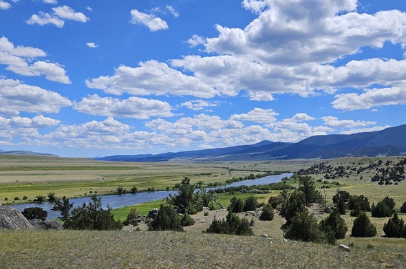
Montana is well-known for its big sky, wide open spaces, and recreational rivers and waterways. (Photo: Madison River south of Cameron, MT. By: Shylea Wingard)
|
|
|
Welcome to the recently revised format for The Montana Department of Natural Resources and Conservation (DNRC) floodplain newsletter. This quarterly edition highlights upcoming educational events and lessons learned from recent flood events in Montana and Texas. The intent is to improve floodplain knowledge of community officials, property owners and floodplain administrators to keep our Montana communities reasonably safe from flooding. Your articles, comments or suggestion are invited.
|
|
Montana Floodplain Program
The DNRC floodplain program promotes common sense planning in flood-prone areas. Floods are the nations most common natural disaster. Building state and community floodplain management expertise and capability are critical to flood risk reduction. Local communities are tasked with managing flood-prone areas and communicating risk awareness to the public. Mapping, permitting, insurance and mitigation are the cornerstones of a community program to better protect public health, safety and welfare.
|
|
Assessing Flood Risk to Identify a Community's Potential for Flooding
How Flood Risk is Identified
Flood risk identification in the United States is led by the Federal Emergency Management Agency (FEMA). The process relies on mapping and engineering studies designed to outline the potential for flooding in specific communities. These studies begin by collecting historic flood data, rainfall patterns, meteorological and topographic information, plus details about local development and flood-control measures.
Flood Insurance Studies and FEMA Maps
FEMA produces Flood Insurance Rate Maps (FIRMs) and Flood Insurance Studies (FIS) which evaluate the flood hazard along rivers, streams, lakes, and coastal areas. Engineers use a combination of hydrologic and hydraulic data, meaning how water flows and accumulates, to determine which areas are most susceptible to flooding.
Understanding Floodplains
Key risk zones on FEMA’s maps are defined as:
- 100-year floodplain: An area with a 1% annual chance of flooding.
- 500-year floodplain: An area with a 0.2% annual chance of flooding.
These classifications are commonly used to inform property owners, guide land use decisions, and determine when flood insurance or special permits are needed.
Importance of Flood Maps
FEMA flood maps not only help residents understand their property’s risk but also guide community officials and local governments in managing land, planning development, and protecting public safety. These maps impact which projects require floodplain permitting and dictate requirements for flood insurance coverage.
For more information visit: FEMA Guidance for Flood Risk Analysis and Mapping - Project Planning.
|
|
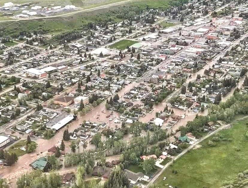
The streets and residences of Red Lodge, Montana were inundated by riverine flooding on June 13, 2022. (Photo by: Courtney Long. Used with permission.)
|
|
Floods Happen. Who Pays?
Floods are the most common natural disaster in the United States, and their financial aftermath is almost always a patchwork of insurance shortfalls, loans, fundraising, and heavy personal costs. Often flooding occurs swiftly with little warning making it difficult for property owners and communities to prepare.
Major Floods in Montana and Texas
- On June 13, 2022, residents of Red Lodge, Montana woke to historic flooding by Rock Creek. Over 150 homes were flooded as water ran down main street and into residential neighborhoods. Damage was widespread over 150 miles and multiple counties. Today many of those communities and property owners still struggle financially to recover, and repair or rebuild property and infrastructure.
- On July 4, 2025, Kerrville, Texas endured catastrophic flooding as the Guadalupe River surged 26 feet in under an hour, destroying over 117 homes and causing at least 119 deaths. The flood damaged over 700 structures along the regulatory floodplain, with 50% designated "substantially damaged" - which means they will need to comply with floodplain regulations if repaired or rebuilt.
Who Pays?
-
Flood Insurance Gap: According to Consumer Reports, fewer than 5% of U.S. homeowners carry flood insurance, even in areas at risk. Standard homeowners policies do not cover flood damage, leaving many exposed to devastating out-of-pocket costs.
-
Federal Assistance: Federal Emergency Management Agency (FEMA) aid is often available after a disaster declaration but typically covers only a fraction of rebuilding and recovery expenses. The National Flood Insurance Program (NFIP), run by FEMA, provides limited insurance coverage.
-
Loans, Not Grants: Many survivors, unable to secure sufficient grants or insurance payouts, turn to Small Business Administration (SBA) loans for help, loans that must be repaid.
-
Long-Term Recovery: For both individuals and local governments, recovery often means exhausting savings, taking on new loans, raising taxes, or tapping emergency reserves to fund new infrastructure. Communities like Red Lodge and Kerrville have each faced repair bills in the multi-millions to address damages and to implement more resilient rebuilding.
Both Montana and Texas residents experienced destroyed infrastructure, property loss, business interruption, economic damage, not to mention, emotional stress. Flood victims quickly learned "getting back to normal" takes time.
|
|
What Does Building Above Base Flood Elevation Mean?
Placing homes and other structures at higher elevations is one of the most effective flood safeguards. For this reason, floodplain standards regulate to a Base Flood Elevation (BFE), meaning that all structures in the designated floodplain must meet or be higher than the BFE, which is defined as the elevation of surface water resulting from a flood that has a 1% chance of equaling or exceeding that level in any given year.
Establishing the BFE is an involved process that follows scientific methodology. Some waterways have detailed studies and the BFE is defined and shared publicly on FEMA flood maps or by other data. Other waterways have not been studied, and the burden falls to the property owner to establish the BFE. Floodplain permitting often hinges on the BFE and a professional surveyor or engineer is needed to calculate the BFE which adds to project costs. (To check your BFE, see the FEMA Map Service Center website or ask your local floodplain administrator.)
BFE is established based on a 100-year flood event (1% chance defined above). So, what happens when a home or structure experiences a 500-year or 1,000-year flood event?
The recent tragedy in Texas can help illustrate. Floodplain permit records show the floors of all Camp Mystic's cabins were higher than the Base Flood Elevation. It is important to understand that the cabins were categorized as "reasonably safe from flooding," but in this extreme 1,000-year flood event it was not. (NOTE: there are other factors such as debris jams which re-route flood flows and make it difficult to model flood behavior.)
Many community officials struggle to balance construction requirements, safety, and the financial burden of building structures to withstand the volume and velocity of a 500-year or 1,000-year event. Conversely, the standard for a 100-year flood event generally requires less reinforcement and cost. Knowing the flood risk (via floodplain mapping studies) can provide some assistance, but there are many unknowns, and the stakes are high knowing human lives - especially those of emergency responders - are at stake. Hindsight is always 20-20.
|
|
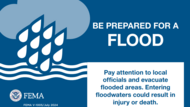
Be Prepared for a Flood
Check out FEMA's "Be Prepared for a Flood" information sheet to learn more about how to protect yourself before, during and after a flood.This is a great resource to share in your community.
|
|
Safe Cleanup After a Flood
What should property owners do to safely clean up after a flood?
- Always check with your local officials on how to begin cleaning up
- Take photos to document and file insurance claims
- Wear protective gear
- Be careful around power lines
- Beware of hazardous materials
|
|
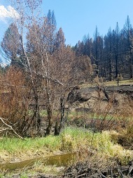
Flood After Fire
Homes in or near wildfire burned areas face a higher risk of flash flooding and mudflows. DNRC and the Montana Commissioner of Securities and Insurance encourage you to plan ahead and protect your home by purchasing flood insurance. Check with your insurance company to see if you are covered for flood damage. New policies generally take 30 days to take effect, so remember to plan ahead.
Visit MTfireinfo.org for more information on wildfire impacted areas.
To learn more about how flood risk increases after a wildfire see FEMA's Flood After Fire Factsheet.
For more flood-after-fire or flood insurance information, visit: Flood - Montana Commissioner of Securities and Insurance.
|
|
Reclamation Development and Planning Grants Due October 15
DNRC administers the Reclamation and Development Grants Program (RDGP). Program information and applications are available on the DNRC Planning Grants website. Several grants available address:
-
High Hazard Dams ($75,000): High hazard dam (Montana Dam Safety Act, MCA 85-15-106) projects that will mitigate damage to natural resources as a result of failure. Planning grants must clearly demonstrate natural resource benefits.
-
Channel Migration Zone (CMZ) Mapping ($75,000): Channel migration zone (CMZ) mapping projects that plan for large-scale flood assessment or other natural resource benefits to a watershed or region of the state. Projects must identify the natural resource needs of the area and include prioritization of projects benefiting natural resources.
-
Other Crucial State Need ($50,000): Projects that meet a crucial state need must prevent or eliminate severe and unacceptable damage to natural resources or capture extraordinary public benefit that would otherwise be lost. They must have a regional, watershed, or statewide importance. Public benefit from this type of project must directly relate to natural resources.
|
|
Montana Disaster & Emergency Services Needs Your Input!
MT DES needs your help with their 2025 Emergency Management Training and Exercise Needs Survey. The survey will gather information to improve emergency management training and exercises for the State of Montana. It is not limited to emergency managers - input from all partners and stakeholders is welcome. Deadline to submit is October 3rd.
Please note that you cannot save the survey. It must be submitted for your answers to be recorded.
If you would like to request an alternate version to provide survey responses via a fillable document, or over the phone, please email mtdesprep@mt.gov.
|
|
Education and Training
October 6-8, 2025: Montana Association of Planners (MAP) Conference (Helena, MT). MAP Registration. Note: DNRC Floodplain presents on October 7 at 4 P.M.
October 8-10, 2025: Montana Chapter American Water Resources Association (AWRA) Conference (Great Falls, MT). Register at: montanaawra.org
October 14-16, 2025: Montana Emergency Managers Association (Lewistown, MT). More information at: Montana Emergency Managers Association - Events
November 12-14, 2025: Montana DNRC Resource Seminar - 3 days of virtual learning. - If you would like to present, please contact shylea.wingard@mt.gov. Zoom invite and agenda will be emailed October 15.
December 2-4, 2025: Public Information Basics - L0105 (Fort Harrison, in Helena, MT). Register by emailing Betsy Ross (MT DES) at betsy.ross@mt.gov.
|
|
|
AMFM Conference February 24-27
The Association of Montana Floodplain Managers (AMFM) will host its 26th annual Conference in Great Falls on February 24-27, 2026. The conference offers floodplain management resources to improve education about regulations, best practices, and assist with flood risk, safety, and mitigation. Each year the annual conference brings floodplain professionals from all areas together to promote common sense floodplain development for Montana. Get more information, register, and become an AMFM member at mtfloods.org.
|
|
|
The Association of State Floodplain Managers Conference will be held on the shores of Lake Michigan on May 31 – June 4, 2026. The ASFPM’s 50th Annual National Conference will celebrate five decades of flood risk reduction and community resilience. “The Fresh Coast Legacy: 50 Years of Floodplain Management,” will feature virtual and in-person opportunities.
|
|
|
October 15 - 16, 2025: MEMA Annual Conference - Lewistown. See website for registration.
October 14, 2025: Two Options for Pre-MEMA Conference Training. Choose to attend "Planning for Disaster Debris Management" (MGT-460) or "Social Media Engagement Strategies" (PER-343)
|
|
Contact DNRC Floodplain's Community Assistance Program (CAP)
Traci Sears, DNRC Floodplain State Coordinator - National Flood Insurance Program Ph. (406) 444-6654 | tsears@mt.gov
Shylea Wingard, DNRC Floodplain CAP Assistant / Floodplain Planner Ph. (406) 581-5254 | shylea.wingard@mt.gov
|
|
|
|
|