|
Summer 2012
Volume 1, Issue 1
Inside this Issue
Meet Your Watershed Coordinator
Big River Watershed
What is a Watershed
Improving Water Quality with the Sun
How can you help?
Soil and Water Conservation Districts Commission Meeting
Belews Creek Watershed Partnership
Upcoming Events
Aug. 25-26, 2012
45th Annual Operation Clean Stream
This event mobilizes 2,000 volunteers on the Meramec, Bourbeuse, Big, Huzzah and Courtois rivers to remove litter and debris. If you or your group are interested in participating, contact the Open Space Council at 636-451-6090.
Aug. 26, 2012
Cherokee Landing Tire Roundup
Bonne Terre
Join those heading to Cherokee Landing for their tire roundup on the Big River in Bonne Terre. For more information or to register, go to www.cherokeelanding.com.
Sept. 26-27, 2012
America's Great Watershed Summit
Hilton, St. Louis
The summit will feature speakers celebrating the vast diversity and opportunity inherent in the Mississippi watershed, examining the critical need for integrated management approaches, and introducing America’s Great Watershed Initiative. Summit participants will also meet in small facilitated break-out groups where they will be able to provide input, develop recommendations, and discuss the future of integrated watershed management of the Mississippi.
Oct. 13, 2012
Fall Harvest Festival
Washington State Park
This event will begin with a craft fair, sponsored by local Missouri artisans and crafters, from 10 a.m. to 2 p.m. at the Big River Shelter in the day-use area. A free music concert and hay rides will also be among the fun activities planned for this event. This program is free and will surely delight the entire family. Learn more.
Oct. 26, 2012
Missouri Snapshots 2012 Photo Contest
It's that time of year again: Grab your camera and head to a Missouri state park or historic site. Your photographs could win you prizes. For more information, visit Rural Missouri's website.
with your questions.
Non-Profit Group Scrap Tire Cost Reimbursement
Contact the Missouri Department
of Natural Resources' Solid Waste Management Program at
573-751-5401.
Nonpoint Source Minigrant to address NPS water pollution
Contact Missouri Department of Natural Resources' Water Protection Program at
573-751-1300.
Cost Share Practices to prevent soil erosion and protect water resources
Contact your local Soil and Water Conservation District
Integrated Research, Education, and Extension Competitive Grants Program
Contact National Institute of
Food and Agriculture;
USDA at 202-205-5952.
Community Stewardship Grant Program
Contact the Missouri Department of Conservation at 573-751-4115.

Missouri Department
of Natural Resources
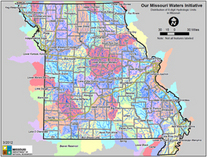
Our Missouri Waters Initiative
Big River Watershed
7545 S. Lindbergh Ste. 210
St. Louis, MO 63125
|
 Hello, I am Tracy Haag. I work for the Missouri Department of Natural Resources' St. Louis Regional Office. I have worked for the department for 23 years.
The Missouri Department of Natural Resources launched a new watershed management approach that we call Our Missouri Waters initiative. We have started in three pilot watersheds; the Big River, the Spring River and the Lower Grand River. We are the coordinators for the Big River Watershed.
Overall, the Our Missouri Waters initiative will take a coordinated, holistic approach to watershed management across the state. One of our goals is to integrate department's programs and services more effectively, which will help us maximize efficiencies, target resources and achieve greater environmental benefit. Another goal is to work with partner agencies, local entities and stakeholders to improve watershed planning.
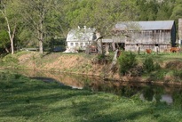
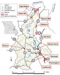 The Big River watershed encompasses Iron, Washington, St. Francois, Ste. Genevieve, Jefferson and Franklin counties.
The Big River flows northward for 138 miles until it reaches the Meramec River.
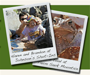
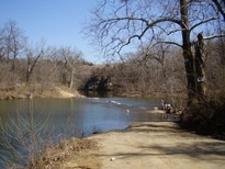 Bone Hole access to the Big River.
Although the affect on the Big River resulting from historic mining activities is a big part of the story, it is not the only concern.
Our role as the coordinators is to meet as many of the interested parties as possible, find out what is needed (or wanted) in the watershed and to make the necessary connections so that more opportunities are utilized to maximize the department’s effectiveness and to increase the benefits to the public.
by Mike Hefner
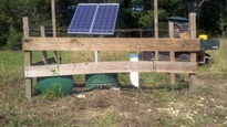
Although this not a new idea, it was new to me. I wanted to improve water quality in the stream running through my property to provide a better recreational place for my son. Years of cow calf management allowing unrestricted access to the stream was providing only marginal swimming opportunities. I called the local soil and water district office in my county and began to ask about programs to assist me in my quest.
Helpful personnel laid forth a plan to fence off the creek in phases and assisted with providing an alternative water source. I wanted to provide water to the herd without an ongoing monthly meter and power bill and chose a solar pump that pulls water from the stream.
The solar pump is capable of pumping water to multiple pastures that are fenced off from the stream to tire water tanks located in the center of the fields controlled by floats.
Within a couple of years, Mother Nature has provided a much cleaner place for my family to play along the creek.
Initially, I thought I would be giving up production by fencing of the creek corridor. Much to my surprise, placing available water in a more central location in the field has forced the herd to better utilize the grass over the entire pasture.
Now that a water source is available in the center of my fields, cross fencing into smaller paddocks is in my future as I head to rotational grazing. Rotational grazing may even be the ticket to a small expansion in my herd.
All of this was made possible through the Missouri Department of Natural Resources' Soil and Water Conservation Program along with technical support through the U.S. Department of Agriculture. My goal is to provide the best customer service possible. If I can be of assistance, please don’t hesitate to contact me at 573-840-9485 or at Mike.Hefner@dnr.mo.gov.
Stream bank Stablization Workshop
by Tracy A. Haag
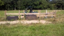
The U.S. Environmental Protection Agency, through the Missouri Department of Natural Resources, has provided funding for a Stream Bank Stabilization Project along Belews Creek under Section 319 of the Clean Water Act. The department’s Water Protection Program administered the grant funds. The department is committed to working closely with land owners, communities and businesses to assist with funding efforts that improve water quality in Missouri.
The Belews Creek Watershed Partnership stream bank stabilization project started April 10th. The location of this site was on Klondike Road, near the bridge, just off State Highway BB. The project began with a workshop conducted by David Derrick of the US Army Corps of Engineers. The workshop was sponsored by Jefferson County Stormwater Management and the Belews Creek Watershed Partnership.
Project pictures have been posted on our Big River Watershed Facebook page, so check it out and “Like” us!
 Before stream bank stabilization.
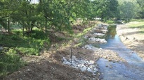 After stream bank stablization.
For more information about the department's 319 grant funding opportunities, contact the Water Protection Program at P.O. Box 176, Jefferson City, MO 65102 or call 800-361-4827 or 573-751-1300.
|
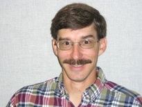 Hello, I am Mike Hefner. I work for the Missouri Department of Natural Resources' Southeast Regional Office. I have worked for the department for 21 years.
by Mike Hefner
A watershed is the area of land where all of the water that is under it or drains off of it goes into the same place. John Wesley Powell, scientist geographer, put it best when he said that a watershed is:
"that area ...of land, a bounded hydrologic system, within which all living things are inextricably linked by their common water course and where, as humans settled, simple logic demanded that they become part of a community."
Watersheds come in all shapes and sizes. They cross county, state and national boundaries. In the continental U.S., there are 2,110 watersheds; including Hawaii, Alaska and Puerto Rico, there are 2,267 watersheds." (Excerpt from EPA website)
The Big River Watershed is located in east-central Missouri and drains 955 square miles of the Ozark Plateau in portions of six counties. Big River has eight, large tributaries and flows northward for 138 miles until it reaches the Meramec River.
by Tracy A. Haag
As a Big River Watershed coordinator, I want to be able to find out what resources exist within the watershed, which ones are important to you, which ones you want to improve, and to help you find the funding and the guidance to get things done.
If you know people that I should know, organizations that I should coordinate with, meetings that I should be attending please let me know. I want to help you make the Big River Watershed all that it can be and a model for the rest of Missouri.
In addition to taking an inventory of the watershed, I also want to help get watershed groups started.
In order to do so, I’m looking for volunteers who want to be involved in protecting water quality in their own backyard. We all live, work or recreate downstream of someone else so water quality is important to everyone. There are numerous Stream Teams that are active on the Big River. I would like to contact them to see what activities they are involved in.
I’m interested in talking to schools, local governments and other organizations. I am interested in what activities they are currently involved in and to help them move forward.
If you would like more information, or would like to help me, please call or email me at 314-416-2452 or tracy.haag@dnr.mo.gov.
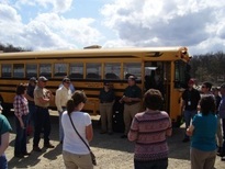
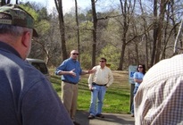
The Missouri Soil and Water Conservation Districts Commission held their March meeting in Park Hills on Wednesday, March 21.
We invited the commissioners and interested members to join us on a tour of the St. Francois County portion of the Big River Watershed.
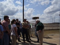
We started the tour at the Missouri Mines State Historic Site where Art Hebrank gave us an outstanding overview of the lead mining history in the area.
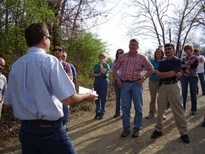
We met Bill Bonnell and Sandy McCain at St. Joe State Park and saw how the tailings site is being utilized as a very popular off-road-vehicle riding area.
 On our drive to the next stop Greg Bach, with EPA, provided great information on both the Elvins tailings pile and the National Mine tailings pile.
Our next stop was St. Francois State Park, where we met Joe Blum and we were able to see first-hand how the tailings have affected the Big River.
 After leaving the park, we visited a local recreational spot on the Big River, known as the Bone Hole Access, in St. Francois County.
Commissioner Patrick Mullins spoke to us about local issues. Greg Bach spoke at this location as well detailing lead testing that has been conducted.
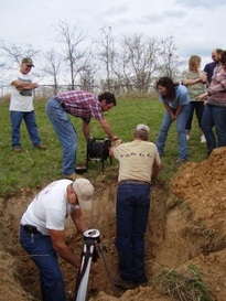
Our last stop of the day was a very informational site visit on Jim Brown’s property. Mr. Brown, with the assistance of Ken Gilliam, 319 technician, talked to us about the mining test holes that dot the St. Francois County landscape and showed us how to properly close them in order to protect water quality. The closing of test holes is being funded by the Water Protection Program’s 319 grant funds.
We were able accomplish all of this in a six hour tour. We had a beautiful sunny day and all the attendees were such good sports even when I relentlessly pushed them to maintain our schedule. There is so much more to see, and hopefully we can continue to plan other tours in the rest of the Big River Watershed in the future.
|