|
The Lower Missouri-Moreau River watershed is
located in central Missouri and includes Boonville, Columbia, Jefferson City,
Fulton, and their surrounding communities.
This watershed includes the tributaries that flow into the Missouri
River and the tributaries to the Moreau River. The Moreau River flows into the
Missouri River just east of Jefferson City.
The estimated population of the Lower
Missouri-Moreau River watershed was 289,254 people in the year 2000 and was
329,758 people in the year 2010. It is
estimated that from the year 2000 to the year 2030, 11 of the 13 counties of
the watershed will experience growth in population, with the most growth
occurring in Boone County, with a projected increase of 51%.
There are 43 community public water systems
within the watershed. Thirty-one of these systems treat groundwater, six
systems purchase treated groundwater, three systems treat surface water, and
three systems purchase treated surface water. Surface water sources in the
watershed, including the Missouri River at Boonville and at Jefferson City and
Fayette Lake #3 provide drinking water supply. Surface water sources outside
the watershed including Mark Twain Lake and Long Branch Lake also provide
drinking water to people in this watershed.
 Lower Missouri-Moreau watershed includes parts of Saline, Howard, Randolph, Boone, Audrain, Callaway, Montgomery, Osage, Cole, Miller, Moniteau, Morgan, and Cooper counties
The Missouri River Water Trail website at http://missouririverwatertrail.org/
provides information for people interested in boating or paddling the Missouri
River within the state of Missouri. The website includes a water trail map that
shows the locations of access areas on the Missouri River. If you click on an
access point, you can then click a link to go to Google Maps to identify
services in the nearby area. The website also provides safety and navigation
tips, links to current river levels, water temperatures, weather forecasts,
history of the Missouri River and Louis and Clark expedition, downloadable GPS
information, additional maps, links to places to stay along the river, and
links to relevant books and other water trail websites.
After viewing this website, you may want to start
planning a Missouri River paddling trip.
Finger Lakes State Park is located north of Columbia
off of Hwy 63. The park gets
its name from the slender lakes formed when former coal mining pits were dammed
and filled with water. Peabody Lake is the largest lake and now has a 4.5-mile
water trail. The water trail is divided into two loops, one marked with red
bouys (2.3 miles) and one marked with blue bouys (2.2 miles), and there is a
.40-mile trail connecting the two loops that is marked with white buoys. Buoys
are placed every .10 of a mile on the path of the trail. The park rents kayaks and canoes for visitors
who don’t have their own.
Last year, the College of Agriculture, Food and
Natural Resources (CAFNR) at the University of Missouri-Columbia formed the
Center for Watershed Management and Water Quality. On April 16, 2015, the
Center hosted its inaugural symposium at the Bond Life Sciences Center. The
symposium, entitled “Water for Agriculture: Challenges for this Century” was
organized by Dr. Jason Hubbart and Dr. Keith Goyne, director and associate
director of the CAFNR Water Center. The
symposium included a number of distinguished speakers from the University of
Missouri-Columbia, University of Minnesota-Duluth, and state and federal
agencies. The presentations from the symposium are available at http://watercenter.missouri.edu/index_files/Events.htm.
The mission of the CAFNR
Center for Watershed Management and Water Quality is to develop, through
discovery and information dissemination, sustainable solutions to contemporary
watershed management, water quantity and water quality problems to attain
maximum benefit of Missouri’s waters and enhance the environmental, social and
economic status of the State and populace. The objective of CWMWQ
will be to strategically increase research, education, and outreach related to
sustaining and enhancing Missouri’s water resources.
Missouri is now a member of the Midwest Cover Crops
Council. Their website, http://www.mccc.msu.edu/ has a wealth of information, including information about cover crop
species, a cover crop decision tool, innovator profiles of farmers that have
used cover crops on their farms, extension materials and publications, links to
videos, and a calendar of events.
The Cover Crop
Decision Tools on the website are an initiative of the Midwest Cover Crop
Council to consolidate cover crop information by state to help farmers make
cover crop selections at the county level.
Information for each state/province is developed by a team of cover crop
experts including university researchers, Extension educators, NRCS personnel,
agriculture department personnel, crop advisors, seed suppliers and farmers, to
help you select cover crops for your situation. For your location, information
is given for considerations for using that cover crop, including planting,
termination, performance and roles, cultural traits, potential advantages and
disadvantages, and information resources about the cover crop. Check out their
website, you will find a wealth of cover crop information.
Kelly Nelson, Research Agronomist and
Professor, University of Missouri Greenley Research Center at Novelty, and Dana
Harder, Superintendent, University of Missouri Greenley Research Center at
Novelty
There are a lot of benefits of cover crops,
but successful establishment is important to realize their full potential. Intercropping systems usually involve
overlapping the growth period of two crops.
Intercropping radish with soybean could allow earlier radish cover crop
establishment while having minimal effects on soybean yield. Radish cover crops have been promoted
throughout the Midwest, but have been unsuccessful following soybean in northern
Missouri. This is due to a short growing
period following harvest, and freezing conditions usually occur around the
first week of December in northern Missouri and terminate the radish cover
crop. From 2012 to 2014 we evaluated the
effect of radish overseeding planting date in the presence and absence of N
fertilizer on soybean yield, radish biomass, and corn yield the following
year. Overseeding radish in the presence
or absence of 30 lbs N/acre had no effect on soybean yield. Precipitation following overseeding of
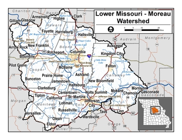
radishes in early September along with an open soybean canopy in 2012 provided
good conditions for successful radish establishment (Figure 1).
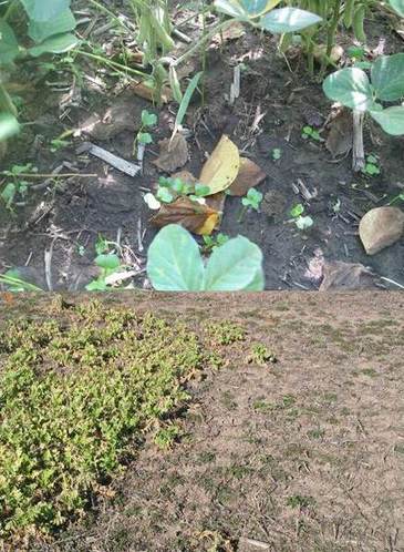 Figure 1. Radish seedlings on September 5, 2012 six days after overseeding (top) and the same plots on December 4, 2012 (bottom left) compared to a later seeding date (bottom right).
Dry conditions following overseeding of radish
in 2013 and 2014 along with a dense soybean canopy in 2014 resulted in poor
establishment of an overseeded radish cover crop (Figure 2).
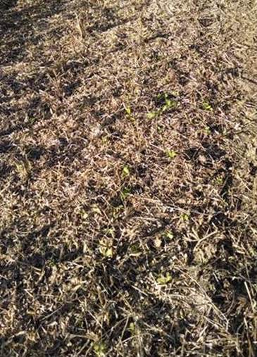 Figure 2. Radish seedlings in soybean residue following harvest on October 22, 2014.
Based on this and other research at the
Greenley Research Center, radish should be seeded before September 1 in
northern Missouri. We have observed that
an early establishment of radish suppressed winter annual weeds 40 to 90% the
following spring (Figure 3).
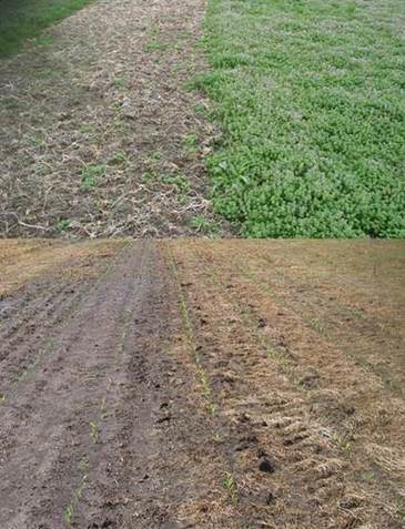 Figure 3. Henbit suppression on March 12, 2012 with radish drill seeded on September 1, 2011 (top left) and September 26, 2011 (top right). No-till corn was planted in the same areas on May 1, 2012.
Farmers should take note of their residual
herbicide program and any effects it may have on the establishment of a cover
crop. Radish is sensitive to several
residual herbicides used for weed control in soybean. Corn yield following radish overseeded into
soybean was not affected in 2013 or 2014.
Radish growth was maximized when overseeded prior to September 1 when
there was an open soybean canopy and rainfall followed the overseeding
event. If you are planning a cover crop
blend, radish could be included if it was seeded prior to September 1 in
northern Missouri. More details on this and other cover crop research at the
Greenley Research Center is available at:
http://greenley.cafnr.org/cover-crops-abstracts/.
A new resource booklet is now available for
educators in Northeast Missouri. The booklet, entitled Land and Water Education Resources for Northeast Missouri, provides
a list of the curriculum, activity guides, field science and discovery
programs, items available for loan, soil health resources, and displays
available for guest presentations (pending staff scheduling and availability)
in Northeast Missouri. The booklet is available on-line at http://dnr.mo.gov/education/resources.htm.
The
booklet is a living document, so if you know of additional resources that
should be added to the booklet, please contact Mary Culler at Mary.Culler@dnr.mo.gov. Please share this resource with educators in
your area.
Promoting,
Protecting and Enjoying our Natural Resources. Learn more at dnr.mo.gov.
|