|
March 2014
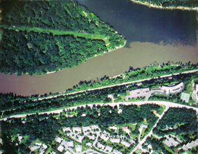 Clearer water for aquatic life and recreation is the goal of a draft strategy to reduce sediment in the Minnesota and Mississippi rivers (photo at right shows confluence of rivers in St. Paul). The Minnesota Pollution Control Agency (MPCA) recently released the strategy for public comment. Citizens can learn about the strategy and provide comment at the following open houses:
- Wednesday, April 2, Blue Earth Public Library, Mankato, 1:30-3:30 p.m.
- Tuesday, April 8, St. James Hotel, Red Wing, 2-5 p.m.
- Thursday, April 10, Minnesota Valley National Wildlife Refuge, Bloomington, 2:30-4:30 p.m.
Excess sediment — primarily clay and silt — contributes to cloudy, murky water, which degrades habitat for fish and aquatic life, and lowers the aesthetic quality of our rivers for recreation and tourism. Both the Minnesota River and the Mississippi downstream south of the metro Twin Cities have sediment levels that fail to meet water quality standards. The standards are designed to protect aquatic life such as fish and aquatic recreation such as swimming.
For the Minnesota River, the strategy proposes interim targets of a 25-percent reduction in sediment by 2020 and a 50-percent reduction by 2030. An 80-90 percent reduction from current sediment loading is needed to meet the goal for the Minnesota River in a study called a Total Maximum Daily Load (TMDL). A TMDL determines the amount – or load – of a pollutant that a river can accept and still meet water quality standards. The South Metro Mississippi River sediment TMDL also requires significant reductions from current loading.
Significant changes in policy, technology and the science behind these issues are expected during the next two decades. Because these changes may influence planning efforts in unforeseen ways, a focus on meeting shorter-term goals will help ensure that each step of the implementation process is based on current data and information.
Because the majority of the suspended sediment load in the South Metro Mississippi River comes from the Minnesota River, efforts in the Minnesota River basin directly affect downstream areas. Sediment erosion in the Minnesota River Basin and its tributaries comes from four main sources:
- Uplands — surface erosion from areas of exposed soil;
- Urban areas and other developed land uses;
- Ravines and gullies;
- Bluffs and streambanks.
According to several scientific studies, the greatest contributors to increased sediment in the Minnesota River are ravines, bluffs and streambanks, often referred to as “near-channel sources.”
Regardless of the main cause or causes, many of the solutions are the same. They can range from traditional conservation practices that reduce soil erosion on cropland, to innovative practices and programs that increase water storage on the land.
The strategy provides a framework that focuses on both policy issues that can affect soil erosion and conservation efforts, as well as strategies and actions that can be used to meet local sediment reduction goals. It acknowledges the complexity of land use and geographical issues facing sediment reduction goals.
It emphasizes the importance of citizen involvement in setting short- and long-term goals, tracking progress and adapting to future research and monitoring.
The TMDLs are part of a nationwide effort under the federal Clean Water Act to identify and clean up pollution in streams, rivers and lakes. The sediment strategy relates to the forthcoming TMDL reports for the Minnesota River and South Metro Mississippi River. Following the reports, the MPCA will work with local partners to develop plans to reduce the pollutants.
The strategy is open for public review and comment through April 17, 2014. Questions and comments can be submitted to Larry Gunderson, Minnesota Pollution Control Agency, 520 Lafayette Rd. N., St. Paul, MN, 55105, email: larry.gunderson@state.mn.us, phone: 651-757-2400 or 800-657-3864.
|
In what may have been its final meeting, the Minnesota River Board gathered Feb. 24 in North Mankato to work on administrative details prior to closing down the organization, and the State of the Minnesota River progress report. On Dec. 16, 2013, the Board voted to disband, with a recommendation only that the state look at creating a new entity with a stable funding source to replace it.
The U.S. Environmental Protection Agency (EPA) recently approved the TMDL report for Lura Lake in southern Blue Earth County and northern Faribault County. Lura Lake is impaired by excess nutrients, and a significant reduction in nutrients entering the lake from surrounding land is needed, as well as in-lake treatments. This lake is located in the Minnesota River Basin.
MPCA Commissioner John Linc Stine will speak at the State of Water Conference, being held May 1-2, by Conservation Minnesota at Cragun’s Resort near Brainerd, Minn. Also speaking at the conference will be Barb Naramore, assistant commission of the Minnesota DNR; John Jaschke, executive director of the Minnesota Board of Water and Soil Resources; and Darby Nelson, aquatic biologist and author of “For Love of Lakes.” Registration is limited and the conference fee is $155.
In addition to the four featured speakers above, the conference program will include more than 70 presenters and 35 breakout sessions. MPCA topics include “Watersheds: How You Fit In,” “Phosphorus and Water – a Recipe for Algae,” “Civic Engagement and Local Governance: Ideas for Creating Change,” “Using the Fish Community to Describe the Condition of Lakes and Streams, “MPCA Funding Resources,” “Minnesota’s Groundwater and Chlorides,” “Investigating Groundwater: Surface Water Interactions on Sentinel Lakes,” “Little Rock Creek Watershed: Irrigation and Stream Flow,” “The Clean Water Act: Pathways to Clean Water,” “What’s in the Runoff,” and “Feedlots: Not in My Backyard!”
A major event focusing on the Minnesota River and the "Blueway" project are proposed for the agenda at the April 15 quarterly meeting of the Minnesota River Watershed Alliance at Ridgewater College in Hutchinson. At its January meeting, the Alliance voted to continue working on the Blueway goals. The Blueway working group of the Alliance is drafting a proposed agreement with the regional office of the U.S. Fish and Wildlife Service and other federal agencies, to continue work on the goals and objectives contained in the initial Blueway nomination for the Minnesota River. The Minnesota River was in line to become the second major river in the U.S. to receive Blueway designation, when the program was halted by the U.S. Dept. of Interior.
A group of Alliance members have been discussing the idea of a major event this summer focusing on the Minnesota River. It would include discussion and entertainment, and showcase a wide variety of individuals and organizations working on economic, recreation, education, and environment projects in the basin.
The Alliance welcomes ideas and contributions from everyone interested in protecting and improving the economic, recreation and environmental well-being of the Minnesota River Basin. All are welcome to attend the Alliance meeting; a potluck meal begins at 6 p.m. and the meeting at 7 p.m. More information is available on the Alliance's blog spot.
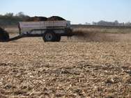 Here is a recent MPCA press release that local partners may use in their newsletters and on their websites. Manure application during snowmelt is a timely topic and proper management is important to water quality.
As winter gives way to spring, rapid snow melt and the potential for flooding pose challenges for farmers who spread livestock manure on cropland. Farmers who spread solid manure during winter must ensure that it doesn’t run off the field, with snowmelt flowing to ditches, streams and other waters.
Manure-contaminated runoff not only threatens water quality, it also reduces the value of manure as a crop nutrient, according to the MPCA. If possible, farmers should refrain from spreading manure during periods of rapid melt. Minnesota rules to protect water quality require a 300-foot setback from surface waters and open tile intakes for all manure spread onto frozen or snow-covered soil.
If temporary stockpiling is not possible and manure land application can’t wait, to help reduce the impact of manure applied to the surface of wet, frozen or snow covered soil, choose the flattest field or flattest parts of fields and follow these guidelines:
- Field slope should be less than 6 percent for solid manure, and 2 percent for liquid manure,
- Do not apply non-incorporated manure within 300 feet of surface waters. If possible apply manure at even greater setback distances.
- Do not apply in portions of fields that contain other areas of concentrated flow. A 300-foot setback is required for intermittent streams; however most fields also contain other areas such as grass waterways that receive concentrated flow. Keep back as far as possible from these other areas of concentrated flow.
- Choose fields that contain the most crop residue; greater than 30 percent is recommended.
- Avoid fields where the furrows are full of ice and snow.
- Keep application rates low enough to avoid runoff or ponding during application.
- Choose fields that do not have adjacent non-tillable land containing areas of concentrated flow such as ravines, ditches with open side inlets, streams or dry runs. If this not possible, stay as far away as possible, from these off-field areas of concentrated flow.
When applying manure on snow-covered or frozen soils, producers should avoid high-risk periods of runoff. These include times when there are two or more inches of snow on the ground and maximum temperatures are forecast to exceed 40 degrees within 24 hours, or when there is a prediction of ¼” or more of rain within 24 hours.
For more information, see the MPCA fact sheet, “Managing manure and land application during adverse weather conditions,” contact your county or MPCA feedlot staff, or call the MPCA at 800-657-3864.
|
|