|
Dear Subscribers of Waterfront Bulletin, BALMM Currents, Watershed Professionals Network and River Connections,
 As subscribers to water quality bulletins and partners in water quality efforts, the Minnesota Pollution Control Agency (MPCA) thought you would be interested in this call for data. The MPCA will conduct surface water assessments – determining whether water bodies meet state water quality standards – for these watersheds in early 2014:
- Leech Lake River
- Pine River
- South Fork Crow River
- Zumbro River
- Red Lake River
- Red River - Grand Marais Creek*
- Lake of the Woods*
* Data requested only for the portions of these watersheds that are within the state of Minnesota.
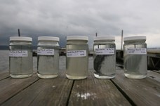
MPCA is interested in obtaining all available water quality data for these watersheds for use in the assessment effort. If you manage a water quality monitoring project in any of these areas, please submit your data, which will help the MPCA assess the condition of these waters and build a national database of water quality. Note the data submission timeline below to ensure that your data is available for the assessment process. To be included in the assessment effort, data must be received by the MPCA and uploaded to the agency’s water quality data management system (EQuIS) prior to data analysis. Be advised that steps involved in data storage for any project can span more than a month. Information on how to submit data is available on the MPCA website.
2013-2014 Data Submission Timeline
-
Through Nov. 1, 2013: Submit project lab and field data.
-
Dec. 2, 2013: Begin final data review.
-
Dec. 16, 2013: Complete final data review for assessment related data.
-
Jan. 15, 2014: Data finalized and ready for the 2014 assessment process.
To ensure adequate time to process your data, you should provide your submittal to the MPCA EQuIS Team by Nov. 1, 2013. Your data will be entered into the EQuIS database and returned to you so that you can review it by Dec. 16, 2013. This is in order to guarantee the data are finalized by Jan. 15, 2014. Data received after Nov. 1 or reviewed after Dec. 16 may not be available to be used in the 2014 assessment cycle.
While the MPCA’s 2014 assessment effort will involve the seven watersheds listed above, the agency is also interested in receiving data from monitoring efforts in other watersheds. The MPCA uses submitted data for:
- Targeting watershed monitoring work;
- Identifying “stressors” that are causing or contributing to problems or threats;
- Managing and evaluating the success of ongoing implementation and resource management; and
- Helping plan for the next round of watershed monitoring.
In addition, the MPCA shares the data with local and state partners and interested parties via its Environmental Data Access (EDA) website and through the federal Environmental Protection Agency’s (EPA) national water quality data warehouse (STORET). Therefore, the agency encourages anyone with monitoring data to provide that data to MPCA for inclusion in the EQuIS database. Because of the watershed assessment timing, data from the identified watersheds will have first priority for processing into the system.
For additional information, contact the MPCA EQuIS Team:
- Nancy Flandrick, 651-757-2361 (St. Paul, Rochester, and Mankato Regional Offices)
- Jean Garvin at 651-757-2378 (Willmar, Marshall, and Detroit Lakes Regional Offices)
- Lynda Nelson at 651-757-2601 (Duluth and Brainerd Regional Offices)
- Stuart Arkley at 651-757-2567 (EQuIS Project Manager)
|
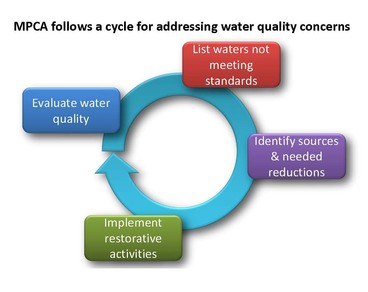
The federal Clean Water Act requires states to monitor and assess their waters to determine if they are supporting beneficial uses such as aquatic life and recreation. This law also requires states to publish a list of waters not fully supporting those uses (i.e., “impaired waters”) every two years.
To meet these requirements, the MPCA monitors waters and gathers water-quality data from state, local and federal agencies, as well as citizens. The MPCA then conducts a rigorous process (assessment) to compare the data against water quality standards to determine if water bodies are supporting their beneficial uses. Waters not fully supporting their beneficial uses are identified as impaired and included on Minnesota’s 303(d) list of impairments (also known as the Total Maximum Daily Load, or TMDL, List).
In recent years the MPCA has transitioned from a statewide approach to a major watershed framework for assessment. Data analysis and assessment by MPCA staff is primarily organized by major watershed, following intensive monitoring of each watershed. This watershed monitoring schedule follows a 10-year rotating timeline. The major watershed framework allows for a comprehensive approach to assessment that considers biological, chemical and physical data together. Some pollutants, namely toxics, are still assessed statewide, because the data collection and management activities are more statewide in nature.
While assessment and listing still occur on an individual stream reach or lake basis, information about the overall health of the watershed is also captured to further inform management activities. The monitoring and assessment efforts culminate in the completion of a comprehensive watershed condition report for each major watershed, which conveys the available information about the health of the major watershed, subwatersheds and individual water bodies within each watershed.
Watershed assessments occur each winter, following the completion of the watershed monitoring. Statewide assessments occur biennially. Every other year, the watershed statewide assessment results are packaged together into the draft biennial 303(d) list of impairments. The draft list is placed on public notice, adjustments are made as warranted by public comment, and the final draft list is submitted to the EPA by April 1 of each even-numbered year.
Your role in collecting and managing the proper entry of these data into the MPCA’s water quality database is important to Minnesota’s effort to identify impaired waters and waters in need of additional protection, and to work with local, state and federal partners to protect and restore Minnesota’s waters. Thank you for your attentiveness to the data management process and the assessment timeline.
|
|