|
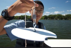
The monitoring season is winding down and we are in our final days to take clarity readings on your lake or stream. After that, yet another Secchi season comes to a close!
We know that monitoring this past summer was challenging for many due to low lake levels and low stream flows. The hot, dry weather felt relentless at times, so we appreciate your efforts in getting out there and taking readings when you could.
As always, we look forward to receiving your Secchi data and ask that you please send it to us by October 31st, if possible. This gives us the time needed to enter it into our database and prepare it for display through our online reporting system.
******ONLINE DATA ENTRY!*********
As a reminder, you can submit your data to us electronically using our new online data entry system. Log in to the MPCA's e-Services system here: https://rsp.pca.state.mn.us/TEMPO_RSP/Orchestrate.do.
All volunteers that participated in the program prior to the 2021 season have automatically been added into this new online system. To access your account and report your data you will need your CLMP or CSMP number. 2021 datasheets unfortunately didn’t include your old CLMP or CSMP ID, but instead used a different identifying number generated through our new software system. Only volunteers new in 2021 can use this new number. If you participated in the program prior to 2021 you cannot use this new number to log into the system.
If you have forgotten your old CLMP or CSMP number, please contact E-Services at onlineservices.pca@state.mn.us or call 651-757-2728 or 1-844-828-0942, 8:00 a.m. to 4:00 p.m. CST, Monday through Friday and they will give it to you.
To log into the system:
- Your user name will be your CLMP or CSMP number (example: CLMP-1111 or CSMP-1234).
- Your temporary password will be your CLMP or CSMP number with “47Acq” added on to the end of it (example: CLMP-111147Acq or CSMP-123447Acq). You will need to update your password upon logging into the system for the first time.
We have posted instructions on our website on how to log-in to the system and submit your data to us: https://www.pca.state.mn.us/water/resources-volunteers.
Back to top
|
By Pete Boulay, Climatologist with the MN State Climatology Office
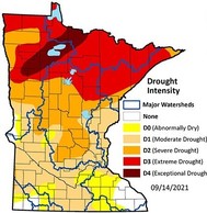
The worst drought in forty years has effected every corner of Minnesota. The drought really began in 2020 with the first dry month being in February. The year finished nearly five inches short of normal in the state. There wasn’t much impact due to the extraordinary wet 2019. January and February started off 2021 dry but then slightly above normal precipitation returned for March. April was relatively dry in the south, but wet in the north. By the end of April, only 15% of the state was designated in drought. May 2021, was dry, especially in the north and the stage was set for an intensifying drought.
Drought conditions expanded greatly across Minnesota over the summer of ’21, thanks to an extraordinary early-summer heatwave in June, along with a continuation of very dry weather. It was Minnesota's third warmest and seventh driest June on record. Stations throughout the state recorded ten or more 90-degree days during the month, while averaging a mere 45% of normal precipitation. By the end of the month, 71% of the state was covered by Moderate Drought (D1) and 10% of the state was under Severe Drought (D2).
July 2021 was a warm month again and the second driest on record going back to 1895. Most places received less than half their normal precipitation. One of the driest locations was Red Lake Falls in northwest Minnesota with a scant .23 inches. The only saving grace was that the extreme heat wasn’t as bad as June. By the end of July, 75% of the state was under Severe Drought (D2), with 22% of the state under Extreme Drought (D3). Rivers and lakes were noticeably lower.
|
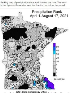
The first three weeks of August continued the dry pattern. On August 10th, a swath of northwestern through north-central Minnesota was designated in Exceptional Drought (D4), marking the first time any part of the state had made it to that level of drought during the 21-year history of the US Drought Monitor. August 24 was peak of the drought so far with nearly half of the state with Extreme Drought (D3) and eight percent of the state under Exceptional Drought (D4).
A wet and stormy period that began on August 24 and continued off and on through August 28th brought at least temporary relief from the worsening drought conditions. The heaviest rains were in the southeast, where Grand Meadow saw over ten inches of rain. The far north saw rain too with five inches in the far northern local of Norris Camp in Lake of the Woods County. Lesser rains fell in the northeast, but enough to blunt the fire danger for a time. Rivers and lakes edged up. Whether this is just a pause in the drought or the beginning of a weather pattern that continues into he fall remains to be seen.
Back to top
|
By Sandy Fecht, DNR EWR Surface Water Hydrologist & Lake Level MN Monitoring Program Coordinator
We never know the worth of water “til the well is dry.” ~Thomas Fuller (1654-1732)
Lakes are one of the hallmark resources of the State of Minnesota -- a part of our heritage, ecology, recreation, economy, tourism, and that quintessential quality of life known as "being at the lake." Droughts remind Minnesotans that our lake resources have limits. Lengthy dry periods have occurred over large areas of Minnesota in every decade of this past century, and typically at least a few weeks every year.
Although Minnesota had a record precipitation year in 2019 at the end of the wettest decade, a major drought overtook Minnesota by 2021. This drought was as serious as anything experienced in over 40 years in some areas, though for most of the state it was the worst drought in 10 - 30 years. Drought conditions expanded quickly across Minnesota during June, thanks to a heat wave and very dry weather. In July, most areas received less than half of their normal precipitation. The drought worsened in the first half of August over all but southeastern Minnesota.
The DNR Lake Level Minnesota Monitoring Program relies on over 900 volunteer monitors and local government partners who record and submit lake levels from gages on more than 950 selected statewide lakes. Concerns from the volunteers intensified over the summer as lake levels continued falling. "I have been on the lake for 42 years and this is the lowest I have ever seen the lake." "Most of this summer I've had about 10 feet of beach that I never had before in 20 years." "The river that supplies our lake with water has been bone dry for two months." "We can’t get our boat off the lift into deep enough water." "What a nasty ongoing drought. SEND RAIN NOW."
|
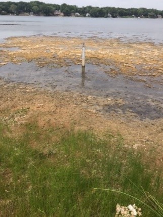
Lake level gages placed in three to four feet of water in spring have ended up in mud or beach (Figure 1). Hundreds of lake gages had to be resurveyed and reset into deeper locations several times over the summer. In August, 39% of the statewide reporting lakes were at Low percentiles, with 23% at Below Normal percentiles, when comparing August lake levels to their entire historic record. Seventy-five percent of the reporting lakes were below their average lake level.
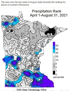
Rainfall in late August to mid-September brought some welcome improvement to the drought across the central and southern parts of the state (Figure 2). Reported lake level percentiles remained the same by mid-September, but now 77% of the reporting lakes were below their average lake level, waiting for replenishment.
Minnesota lakes typically fluctuate 0.5 – 2.0 feet each year. Check out historical lake level data for individual gaged lakes at the non-mobile DNR LakeFinder website. Knowing, understanding, and accepting the history of water level fluctuations can help lake users deal with expectations and problems associated with the changing levels and not uncommon droughts.
© Figure 1 photo by Kimberly Kasper, Pleasant Lake, Stearns County, August 2021.
Back to top
|
As some of you may be aware, the CMP collaborates with the University of Minnesota's Remote Sensing of Water Resources Program, which uses satellite imagery to identify water quality on lakes across the state. Using satellites to assess water quality requires regular calibration with water clarity data collected on the ground, and this is where the CMP comes in. Secchi readings taken by CLMP volunteers (generally within a 1-3 day window from the satellite overpass of a particular lake) are compared with the image generated by the satellite. Correlations between Secchi readings and lake images are used to calibrate the water clarity model.
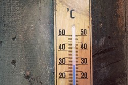
This past spring, these same researchers contacted the CMP looking for volunteer-collected lake surface water temperature data to check the accuracy of lake temperature data gathered from remote sensing projects. Up until now, the CLMP hasn't incorporated the collection of lake surface water temperature data into the program because there wasn't a clear end use for the data. However, with a growing interest in how waters are warming across the state, it seems the need for this kind of data is there. In particular, for the Remote Sensing of Water Resources Program to accurately use lake temperature data from remote sensing projects, data collected by CLMP volunteers will be needed to groundtruth the satellite imagery. In the future, this temperature data will be a key part of being able to predict when lakes are going to bloom and when cold water fish are threatened.
Next year's CLMP datasheet will have a section for reporting lake surface water temperature readings at your monitoring location. Completing this section is optional, as we will not be issuing thermometers to volunteers as part of our standard operating equipment for the program. If you are interested in collecting this data and would like to purchase a thermometer on your own, there are many to choose from at outdoor outfitting stores or other online retailers.
We are excited to expand our collaboration with the Remote Sensing of Water Resources Program by collecting this important lake data. Please feel free to contact CLMP staff with any questions regarding this new data collection initiative by emailing us at clmp.pca@state.mn.us.
Back to top
|
After a hiatus for much of 2020, the Water Exchange will be back for the 2021 season to keep you up-to-date on all the fascinating water-related work going on around the state.
Our November speaker will be Dr. Kenneth (“Kenny”) Blumenfeld. Kenny is a climate scientist who grew up in Minneapolis with a love for storms, blizzards, and being outside. He works for the Minnesota State Climatology Office (Department of Natural Resources), where he provides the state’s agencies, communities, and citizens with up-to-date scientific information about Minnesota’s changing and variable climate. Kenny enjoys talking to Minnesotans about their weather, and often does it long after the work day is done.
Kenny's presentation in November will break down Minnesota’s changing climate to its essential points, particularly emphasizing the ongoing changes in the quantity, timing, and intensity of precipitation, and the rapid rate of winter warming. He will also discuss other important elements of our climate that are not (yet) changing, and will peer into the future to see what lies ahead, according to the best available science.
Date, time and log-in details for the presentation will be provided in early November.
Back to top
|

The transition of our program's volunteer database to a new software system has changed how we track the receipt of paper datasheets. In our old system we were able to log the receipt of your datasheet within a few days of receiving it. You were then removed from receiving any future email reminders to send in your data for the most recent monitoring season.
Our new volunteer database is only updated annually, so even though you may have submitted your paper datasheet for the most recent monitoring season, you will still receive an email or snail mail letter asking for you to submit your data. I understand this may cause confusion on if we have received your data or not. Unfortunately, we don't currently have the staff capacity to confirm to all paper datasheet users that we received their datasheet. If you have submitted your paper datasheet, please disregard the reminder emails and letters. I apologize for this inconvenience. Those volunteers that use the online system are excluded from this issue as the online system feeds directly into our new volunteer database.
Back to top
|

It's important to recognize hard work and dedication, especially when someone is volunteering their time to an important cause. For years the Citizen Lake and Stream Monitoring Programs have recognized volunteers with physical gifts such as t-shirts, hats, coffee mugs, etc... We know volunteers aren't just in it for the swag, but we also understand it's nice to be formally acknowledged for a job well done,and physical tokens are an easy way of doing that.
On the other hand, we are a world rapidly becoming overwhelmed with "stuff". Resources are used to make each recognition item and we as a program want to be conscience of our impact both locally and globally.
We are seeking ways to recognize volunteers for their hard work that either don't involve physical tokens or that involve smaller, more sustainable items that would still be considered useful or valuable to the recipient. The CMP's addition of the annual Secchi Social gathering would be one such example of a "sustainable" recognition, and we are looking for more ideas like this that we could incorporate into our program that would eventually take the place of physical items. We would like to hear from YOU on this transition. We'd like to know how you'd like to be recognized or how other organizations you work for, or volunteer with, recognize participation.
Please send ideas and suggestions to either of our email inboxes at clmp.pca@state.mn.us or csmp.pca@state.mn.us. We look forward to hearing from you!
Back to top
|
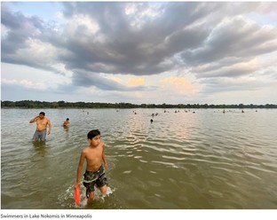
The MPCA recently released the results of an effort to gauge the health of the state’s major recreational lakes. In the first statewide study of its kind, 75% of Minnesota lakes met water quality standards for recreation such as swimming and wading.
While most lakes are good shape, 25% of those studied need lower levels of phosphorus and algae that can be harmful to some aquatic species and hinder recreation.
“The good news is that many Minnesota lakes continue to be some of the highest quality lakes in the nation,” says Katrina Kessler, MPCA assistant commissioner for water policy and agriculture. “The bad news is that some of our lakes continue to suffer from several water quality problems.”
The statistics change by region: Lakes are generally healthy in the northeast, where forests and wetlands are more prevalent, with lake conditions getting worse moving to the south and west, where cropland and urban development are dominant.
For example, in the Rainy Lake Watershed in northern Minnesota, all the lakes studied met water quality standards, while in the Blue Earth River Watershed in southern Minnesota, none of the lakes did. Standards vary by region. In other words, scientists don’t expect lakes in the south to meet the same standards as in the north.
The Clean Water Fund has made a tremendous difference in determining the condition of Minnesota lakes. This ongoing study is funded by the Clean Water Fund, which is derived from the Legacy Amendment sales tax approved by voters in 2008.
“Thanks to the Clean Water Fund, we understand the water quality of lakes across the state," Kessler says. "More importantly, Clean Water Funds are being used to develop restoration and protection strategies to improve and maintain water quality to benefit Minnesotans today and into the future. In concert with local partners, the MPCA has completed strategy reports for 69 of our 80 watersheds, with the rest on track for wrapping up in 2022."
“Minnesota is blessed with a tremendous number of lakes," Kessler says. "We could not begin to check the conditions of major lakes without our valued partners, particularly those at the local level like soil and water conservation districts, watershed management organizations, watershed districts, and lake associations.
“With their continued partnership and ongoing support from the Clean Water Fund, we are committed to monitoring the lakes that Minnesotans value for recreation. In coordination with the Minnesota Department of Natural Resources and the Board of Water and Soil Resources, we will keep working to restore impaired lakes and protect healthy ones.”
Back to top
|

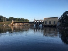
By Scott Ransom, CSMP Volunteer
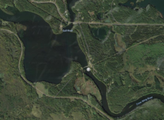
I do stream monitoring on the Crow Wing River behind the Sylvan Dam near Baxter, MN. The Crow Wing River is the northern boundary of Camp Ripley, the 53,000 acre training site for the Minnesota National Guard, State Troopers, and other organizations such as the DNR and Civil Air Patrol. After merging with the Mississippi River a few miles further east, the Mississippi then becomes Camp Ripley's eastern boundary.
|
As a former National Guardsman, I have been to Camp Ripley many times, and had taken every opportunity to see and fish both rivers. I have fished the Crow Wing River behind Sylvan Dam from both sides of the river and occasionally done well. So, upon hearing about the Citizen's Monitoring Program, I decided to look for a place to monitor (https://www.pca.state.mn.us/cmp/enroll) and found the Sylvan Dam site. It was perfect for me - not far away; I could contribute to water quality; I could get my hours; and then I could stay a bit and fish!
|
Wait. "Get my hours?" What's that about?
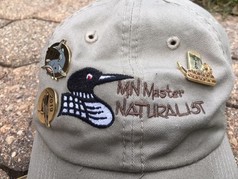
I'm a Minnesota Master Naturalist (https:minnesotamasternaturalist.org). After taking an intro class in 2018, I have continued with it and become part of that community. Our Brainerd Lakes Chapter is a great group of folks that I'm proud to be a part of. Our tenets are Service, Social, Education and Networking. To be in good standing for a year (and to earn a pin!), an MNat (as we sometimes call ourselves) must log 8 hours of advance training and 40 hours of volunteer work. So I am getting the majority of my hours through my stream monitoring.
I enjoy providing the data for valuable citizen science. I enjoy getting to the river and seeing the sights - the dam, the changing water flow over the dam and the varying water level (low this year of course with the drought), the birds and critters along the shoreline. I enjoy wading into knee-deep waters and seeing the fish (little ones...the big ones keep their distance), crayfish (lots of 'em) and other water invertebrates. And I've already mentioned the fishing. But the most memorable time I've had has happened twice. A parent & kid were there and curious about what I was doing with the secchi tube. I showed and explained and let the kids take the reading. Future Citizen Scientists!
Back to top
|
|
|