|
Well folks, 2019 was another wet summer in Minnesota. In fact, it was the wettest year on record for the state - pushing past the previous record set in 1977! According to the State Climatology Office, "Precipitation totals for the year exceeded 30 inches over all but about 5-10% of the state (mainly in far northern Minnesota), with totals exceeding 50 inches in parts of southern and southeastern Minnesota. Well over half of the state was 12-20 inches (or 50-70%) wetter than normal." All this precipitation resulted in high lake and stream levels, which we know can make monitoring a challenge.
We are so grateful for the 939 lake and 430 stream volunteers that braved the wet weather and collected data in 2019. Thanks to all your hard work, we know so much more about the health of Minnesota's lakes and streams (see next article "New Maps Show the Power of Citizen-Collected Data" in this issue of the newsletter).
|
You may have heard us say (just once or twice!) how instrumental Citizen collected data is in helping the MPCA detect water clarity changes over time on lakes and streams. Years of consistently collected data are needed to identify trends, and this has only been possible through the dedication of citizens across the state.
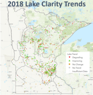
For years we’ve displayed lake and stream trend results on a static map on our website and through each volunteer’s individual site report. We are happy to report that improvements have recently been made so the maps provide greater detail and are more user friendly.
Check out the CMP's Interactive Trend Maps (there is one map for lakes and one for streams) to see 2018 trend results. The maps will be updated with 2019 results this spring. Each map shows if a lake or stream site is improving, degrading, showing no change, or if no significant trend was found. The maps also show where there is not enough data to run the test...yet! With your help, we can collect enough water clarity to run more tests, and greatly improve our understanding of changes to lake and stream water clarity across the state over time.
|
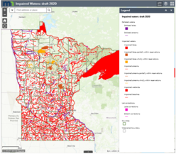
In a new report released in November, the MPCA added 581 new waterbodies to the state’s impaired waters list (i.e. bodies of water that do not meet water quality standards). The MPCA's Impaired Waters Viewer (IWAV) displays all impaired waters across the state, including those just listed.
The 2020 impaired waters list includes:
- 368 streams and 56 lakes that fail to adequately support fish and other aquatic life
- 69 streams and one Lake Superior beach that have high bacteria levels
- 51 lakes and three streams with high levels of nutrients (i.e. phosphorus and nitrogen)
- 32 waterbodies with excess levels of mercury in fish tissue
One bright spot in the report is the removal of four waterbodies from the list where restoration work has improved water quality. Sleepy Eye Lake (Brown County), Faille Lake (Todd County), and Waverly Lake (Wright County) now have nutrient levels low enough to meet recreational standards. Bacteria levels in a segment of Plum Creek (Stearns County) are now low enough to meet recreational goals.
The Plum Creek success story tells how CSMP volunteer Ted Steven played a critical role in collecting bacteria samples that documented lower bacteria levels due to changes to land use practices in the watershed. Thank you Ted, for your dedication and hard work on this project!
|
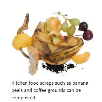
Composting is a great way to reduce waste and improve soil health, but did you know it could improve the health of nearby lakes and streams too?
Popular synthetic fertilizers used on lawns and gardens across Minnesota contribute excess nutrients to our waterways. Nutrients that, when combined with agricultural and stormwater runoff contribute to algae blooms and impaired waters. Can we have green lawns and plump red tomatoes each summer without the use of chemical fertilizers? Indeed we can and the solution is right under our noses!
Food scraps make up 12% of waste produced by Minnesota households and yard waste comprises 18%. However, if we compost our food scraps and grasscycle (i.e. leave grass clippings on the lawn rather than bagging them) we can naturally fertilize our lawns and gardens.
Now you may be asking yourself – if compost is so nutrient rich, why doesn’t it pollute waterways like synthetic fertilizers? This is where the fun comes in!
Compost is wonderfully different from synthetic fertilizers. Compost actually helps build and improve soil structure. It creates space for roots to grow and it holds onto nutrients just tight enough for plants to utilize them, but not so loose that they get washed away. Compost increases soil’s ability to retain water and reduces runoff significantly. Finally, unlike synthetic fertilizers, compost releases nutrients more slowly over time.
During the cold winter months it can be comforting to plan for all the gardening fun that summer brings. So, as you watch the snow fall, start imagining how you can transition from synthetic fertilizers to compost this year. If you’d like tips on how to get started, check out the MPCA’s backyard composting page.
|
 |
|
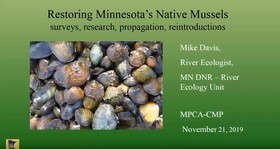
The CMP's popular webinar series has made its way to Youtube. Past episodes of the series are available for streaming on the CMP's YouTube Playlist. With topics ranging from native mussels to shoreland buffers, there is something for everyone. |
The Citizen Monitoring Program Calendar is a great way to highlight your favorite lake or stream, enjoy images from your fellow volunteers, and spread the word about the great water quality work that you do. To make the 5th annual CMP Calendar the best it can be, we need your beautiful, high resolution water monitoring images. Do you have photos of:
- A scenic vista of your stream or lake
- Wildlife that you encountered while monitoring
- An action shot of someone taking a Secchi transparency reading
- Minnesota seasons: spring flowers, summer fun on the water, fall colors, snow & ice too!
Showcase your photograph in the 2021 CMP Calendar by emailing your best images to: csmp.pca@state.mn.us (streams) or clmp.pca.state.mn.us (lakes)
Please note that we need high resolution images (300 dpi or greater) so that they print well.
Thank you for helping to make the CMP Calendar a reality!
|

MPCA and Isaak Walton League of America are teaming up to bring Salt Watch kits to Minnesota
The Isaak Walton League (IWL), a national environmental non-profit, is partnering with MPCA on chloride. IWL created a Winter Salt Watch program in the Chesapeake Bay area in response to the excessive amount of salt being used on paved surfaces. Participants in the program monitor water for excessive salt levels, which can identify a problem.
Salt is toxic to freshwater fish, macroinvertebrates, and amphibians. Once in our waters there is no feasible way to remove chloride (salt) and it is continuing to build up in surface and groundwater across Minnesota. Responsible salt use that provide safe conditions is possible and necessary to protect the health of our valuable water resources.
The MPCA is now collaborating with IWL to bring the Salt Watch program to citizens in Minnesota. Here are the 3 easy steps to participate in the program:
-
Test the chloride in your stream: Request a FREE test kit and follow the instructions you receive with your kit.
-
Share your results on Water Reporter: Download the Water Reporter app (FREE for Apple and Android) and follow the simple instructions
-
Take action: If you find high levels of chloride, let someone know!
For more information and to request a kit visit the IWL Winter Salt Watch website: https://www.iwla.org/water/winter-salt-watch
To learn more about chloride in Minnesota’s water resources visit the MPCA’s chloride website: https://www.pca.state.mn.us/water/chloride-salts
|

By Kelli Saunders, Lake of the Woods Water Sustainability Foundation
Lake of the Woods is a complicated, intriguing and beautifully rugged lake that is intersected by the Canada/U.S. border and by Minnesota, Ontario and Manitoba. With over 14,500 islands, water flow and water quality are complex, but it is a lake that has drawn some well deserved attention.
Research on Lake of the Woods and its watershed gained momentum in 2008 when the south end of Lake of the Woods in the U.S. was declared “impaired” due to levels of phosphorus that exceed state standards. With Minnesota leading the way on research to determine where the nutrients are coming from in order to develop a “total maximum daily load” for the lake, other partners came on board to provide information on the rest of the watershed, including Ontario’s Ministry of Environment, Conservation and Parks, Ministry of Natural Resources and Forestry, the Red Lake Band of Chippewa Indians, Environment and Climate Change Canada (ECCC) and several universities – all who have contributed data to get a more fulsome picture of the nutrient inputs and the processes at work, including climate change. For example, over the past 3.5 years, ECCC has focused on developing satellite tools to identify and monitor blooms; researching the status, trends and drivers of algae blooms; measuring nutrient inputs from shoreline developments; developing a model to help determine the effectiveness of nutrient reduction strategies on the water quality in Lake of the Woods; and, predicting the lake's response to climate change.
|
Despite reductions in phosphorus inputs from point sources on the Rainy River, by far the biggest input of water and nutrients to the lake, what has been found is that Lake of the Woods has accumulated a pool of “legacy” phosphorus in the lake bottom from past decades of pollution. Phosphorus from the mills and sewage waste of decades past has been returning from the sediments and are a factor in fueling large, intense algae blooms on this lake. This recycling process, called internal loading, means that even with the reductions in pollution since the 1970s, it may take a long time for all the recycling legacy phosphorus to be depleted. The science is also showing that climate change is making things worse - this lake is ice-free 20-30 days longer compared to the 1960s and the longer growing season provides conditions for more growth of algae. The good news is that the legacy phosphorus is slowly being flushed out through outflow and burial and has declined to the point that continued reductions of phosphorus from the watershed should be effective.
Minnesota has set a target to reduce phosphorus so the south end of the lake can meet state standards and their plan is currently under review; Canada will consider targets once their research is complete and the overall goal is to collaborate on what is best for the lake as a whole.
Kelli Saunders, M.Sc., is the International Watershed Coordinator with the Lake of the Woods Water Sustainability Foundation.
|

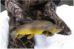
Interested in fly fishing (especially in winter), the diets and behaviors of trout, winter-active aquatic insects and their biology, and how you can help us on research related to trout?
The Chirononmidae Research Group at The University of Minnesota is offering a workshop on these topics in February. Details are provided below. For more information, or to register for the event contact Len Ferrington at ferri016@umn.edu
WHEN: Saturday 22 February 2020, 1:00-4:30 PM
WHERE: Room 480 Hodson Hall, Saint Paul Campus of the University of Minnesota
WHAT: Lectures, demonstrations of live aquatic insects,information about becoming a Citizen Volunteer
Presenters & Topics include:
Dr. Bruce Vondracek--- Fly fishing for trout in winter
Dr. Amy Schrank--- Trout movements & behavior
Dr. Dean Hansen --- Owner of Wet Bugs, demonstration of live aquatic insects; flies to match winter hatch
Dr. Rebecca Swenson --- Citizen Volunteers and how to become involved
Dr. Len Ferrington --- Kinds and biologies of winter growing and emerging aquatic insects
|
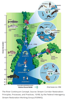
"Because a river changes constantly as it moves downstream, it can only truly be understood as a continuum"
The River Continuum Concept (RCC) was a groundbreaking ecosystem model when it was first introduced in 1980 by Robin Vannote and colleagues at the Stroud Research Center in Pennsylvania. Up until then, rivers had been studied in a piecemeal fashion, one section at a time. The RCC took a more holistic approach to understanding how rivers work, from an upstream to downstream position, based on years of research at various geographical locations across the U.S. The RCC classifies rivers into Headwaters, Midreaches, and Lower reaches based on the physical source of energy inputs to the system and the processing of these inputs by biological organisms along the upstream to downstream continuum.
In Headwater reaches, organic inputs are primarily external, or allocthonous plant material that falls into the stream. Biological organisms (consumers) are mostly 'shredders' that break down the course organic material inputs into finer particles. In Midreach zones, instream organic inputs, or autochthonous production from photosynthesis become more important, with more 'grazers' scraping algae from rocks and 'collectors' filtering finer matter. Further downstream yet, in the Lower reaches, 'collectors' become dominant as light penetration decreases leading to less photosynthesis.
Although the RCC is an accepted river theory, there are limits to its application. For example, it does not account for disturbances such as dams or flooding. Many subsequent studies have added to the concept and our understanding of how rivers work. One of the most magical things about rivers is that they constantly change across space and time! If you would like to learn more about the RCC, here are a few resources to explore:
MN DNR https://www.dnr.state.mn.us/whaf/key-concepts/rcc.html
Stroud Water Research Center https://stroudcenter.org/continuum/
National Science Foundation Long Term Ecological Research Network https://lternet.edu/findings/river-continuum/
|

By Mitch Sanchez, 2019 BWCA Volunteer
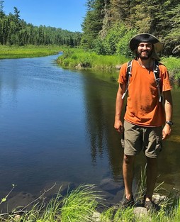
Covering over 1 million acres, with access to 1200 miles of canoe routes, 12 hiking trails, and 2000 designated campsites, the Boundary Waters holds plenty of opportunities for an outdoor enthusiast. I recently embarked on a solo trip over Labor Day weekend 2019 into the Boundary Waters and was able to conduct water clarity tests on 10 different lakes. Like every trip, this one had its ups and it had its downs. I could write a lot about the trip, but will just describe the first day since it is my most memorable day.
I started my journey on Poplar Lake off the Gunflint Trail and went in on Lizz Lake. For most of my solo trips, I prefer to plan what lake I’m going to stay at, in case someone has to come searching for me. This first day, I planned to stay on either Caribou or Horseshoe Lake. As I start paddling on Caribou, I slowly start to realize that EVERY campsite happened to be occupied. I decide to portage on over to Horseshoe. As I paddle pass the first campsite on Horseshoe, I notice it’s taken. Then the second campsite - taken. As I continue to paddle by occupied campsites, I begin to gain animosity toward these campers for taking MY site. As I turn a corner and start heading west (still on Horseshoe), the wind picks up to 20-25 mph. Now I’m battling the wind and still have no campsite. After finally getting to the Gaskin Lake portage, I start to think that I’m going to have to paddle through the night to find a campsite. As I start paddling Gaskin and pass two campsites, I finally make way to the first open campsite of the trip…. 16 campsites later.
That same night, I was fortunate enough to witness the elusive Northern Lights, sitting on a rock, enjoying a well-deserved drink. The lights were so clear and bright that I could see them dancing off the water. For anyone who has not seen the northern lights before, pictures or words do not do them justice. The colorful, dancing lights were breathtaking and something I wish everyone could witness at least once in their lifetime.
The Boundary Waters will make you work for all of its beauty, but the work that you put in reflects in the memories that you take away. I have made so many memories in this beautiful wilderness: lightning striking camp, friends catching their biggest fish, grouse attacks, leaking tents, first fish, and now the Northern Lights.
For anyone that may be reading this, if you are thinking about volunteering for the citizen water monitoring program, it is worth it. It does not take a lot of time or effort and can make a huge difference in keeping our lakes and streams healthy. As Aldo Leopold once wrote, “We abuse land because we regard it as a commodity belonging to us. When we see land as a community to which we belong, we may begin to use it with love and respect.”
|
|
|