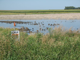
 Soil and Water Conservation Districts (SWCDs) may apply to the Minnesota Board of Water and Soil Resources for funding for additional staff to implement the Conservation Reserve Enhancement Program (CREP) in Minnesota. To be eligible, SWCDs must be in one of the 54 southern and western counties that make up the CREP project.
Up to $4.4 million is available, as provided by the Environment and Natural Resources Trust Fund derived from lottery proceeds. The application period opened Oct. 1 and will continue as long as funding is available.
The purpose of this funding is to accelerate staff capacity to deliver the MN CREP. These funds must supplement any Farm Bill Assistance staff currently in place and may not be used as a substitute. SWCDs may choose to increase staff hours, realign staff priorities to focus on CREP, and/or secure new staff.
For more information, see the program webpage or contact Dusty Van Thuyne, CREP implementation coordinator, at dusty.vanthuyne@state.mn.us or 507.344.2819.
MN CREP is a voluntary, federal-state funded natural resource conservation program that uses a science-based approach to target environmentally sensitive land. The goal is to protect 60,000 acres by enrolling riparian and marginal agricultural land into conservation. Benefits include:
- Restoring hydrology, increasing infiltration and providing flood mitigation
- Providing habitat for wildlife, non-game species and pollinators
- Reducing nitrate loading in drinking supplies
|
The Minnesota Department of Agriculture (MDA) recently released a request for proposals for research related to clean water in agricultural areas of the state. It was announced in the October 22 State Register (page 484). Proposed research should evaluate the effectiveness of agricultural conservation practices, identify underlying processes that affect water quality, and evaluate the costs and benefits of specific agricultural practices. All submitted research proposals should align with one or more of the 2018 research priorities. The MDA has about $400,000 of Clean Water Funds available to support new projects.
Proposals are due by 3 p.m. Nov. 29. A full copy of the RFP is available upon request, by contacting Aicam Laacouri, clean water research coordinator for MDA, at Aicam.Laacouri@state.mn.us.
The MDA is using Clean Water Fund dollars to support agricultural research and evaluation. To learn more about the program and funded projects visit the department’s webpage.
The Minnesota Pollution Control Agency (MPCA) has selected 10 watersheds for longer-term federal funding, starting in 2020. The selections are part of the transition in the federal Clean Water Act Section 319 program from one-time grants to more reliable funding focused on small watersheds. The goal of the program is to help local governments make measureable changes toward water quality improvements. Based on input from many local governments, the program is designed to provide a reliable and longer-term funding source to address all pollutants in small watersheds.
Chosen for prioritized funding in 2020, 2024, 2028 and 2032 are:
- Martin SWCD, for the Fairmont Chain of Lakes and Dutch Creek
- Mower SWCD, for Dobbins Creek
- Redwood County SWCD, for Plum Creek Watershed
- Hawk Creek Watershed Project, for Upper Hawk Creek and Wilmar Chain of Lakes
- Scott County, Scott Water Management Organization, and SWCD, for Sand Creek
- West Polk SWCD, for the Red Lake River – middle subwatershed
- Carlton SWCD, for Skunk Creek
- Buffalo Red River Watershed District, for Whiskey Creek
- Rum River Watershed, for the Rum River – middle subwatershed
- Pipestone County, for Split Rock, Mound, and Pipestone creeks
After 41 local government units applied for funding, the MPCA conducted telephone interviews with all applicants and chose 19 for site visits. The agency then chose 10 for funding based on criteria such as state priorities and collaboration, along with input from the Minnesota Board of Water and Soil Resources.
In 2019, 2020, and 2021, the MPCA will chose additional groups of 10 watersheds for prioritized funding.
For more information, or to state your interest for 2019, visit the program webpage.
 The Minnesota Department of Natural Resources (DNR) recently issued permits for Poly Met Mining, Inc.’s proposed NorthMet mining project in northeast Minnesota.
The DNR has issued the permit to mine, six water appropriation permits, two dam safety permits, a public waters work permit, and an endangered species takings permit for the NorthMet project.
The permit to mine includes a financial assurance plan and wetland replacement plan.
The permit action completes the DNR’s consideration of the major permits that the project needs from the DNR in order to proceed. However, the NorthMet project still requires water and air quality permits from the Minnesota Pollution Control Agency (MPCA) and a wetlands permit from the Army Corps of Engineers, in addition to other local permits and approvals. (See story below for update on MPCA permits.)
“No project in the history of Minnesota has been more thoroughly evaluated,” said DNR Commissioner Tom Landwehr.
“Based on the DNR’s review, we are confident that the project can be built, operated, and reclaimed in compliance with Minnesota’s rigorous environmental standards, which are designed to protect human health and the environment,” Landwehr said. “This does not mean that the project will not have impacts, but it does mean that the project meets Minnesota’s regulatory standards for these permits.”
The NorthMet project would create an open pit copper, nickel, cobalt and precious metals mine and would refurbish a portion of the former LTV Steel Mining Company processing plant. The project is located near the cities of Hoyt Lakes and Babbitt.
See the full press release on the DNR website.
Online public information
The DNR and MPCA have a joint web portal for the PolyMet project at polymet.mn.gov where the DNR’s final permits and additional documents related to these permit decisions are available.
|
In response to comments received during the public notice period (Jan. 30 to March 16, 2018), the MPCA revised the draft air quality and water quality permit documents for the Poly Met Mining, Inc.’s NorthMet mining project. The agency recently sent the revised air and water quality permits and support documents to the U.S. Environmental Protection Agency (EPA) for review.
This is not a final decision of the MPCA, nor is this a public comment period. Sending the revised draft permits to EPA is a normal step in the air and water permitting process as part of the federal oversight of the state permitting programs. In the interest of ensuring transparency for this high-interest project, MPCA is taking the additional step of posting the revised permits online at www.pca.state.mn.us/northmet.
The MPCA considered the nearly 700 public comments, which resulted in the addition of numerous conditions to the permits. For example, the MPCA revised the draft air permit provisions to clarify conditions for fugitive dust control management and recordkeeping, and add monitoring and recordkeeping requirements. Examples of changes made to the draft water quality permit include adding additional permit limits and providing greater clarity on requirements related to the construction and operation of engineering controls (such as seepage capture and wastewater treatment systems).
Next steps
The EPA will be reviewing the permits in the coming weeks. Following consideration of any EPA feedback, the MPCA commissioner will make a decision on issuance of the permits. The intent of the MPCA is to make final permit decisions by the end of this calendar year.
Related media coverage:
 Streams in the Mississippi River-La Crescent watershed support good water quality, except the lower part of Pine Creek, which has high sediment contributing to poor habitat and temperature conditions, according to a stressor identification report by the MPCA. The Mississippi River-La Crescent watershed drains 95 square miles in Houston and southeast Winona counties, an area defined by wooded bluffs and spring-fed cold-water streams that flow directly to the Mississippi River. Pine Creek is the largest cold-water tributary in the watershed, draining more than half of the entire watershed (58 square miles).
Pine Creek runs through a steep valley with erodible soils. The upper part of Pine Creek – where it originates – is in good condition. However, downstream the creek tends to have high levels of sediment that make the water cloudy. These natural conditions, coupled with poor pasturing practices, cattle accessing the stream, and higher flows eroding the streambanks, result in sediment clouding the water. Pine Creek worsens in habitat and temperature conditions moving downstream: stream temperature and sediment from erosion increase while habitat decreases, along with expected numbers and types of cold-water fish and bugs.
This area is known for trout fishing and karst geography. The erosive effects of water have sculpted thick layers of limestone over thousands of years. The landscape is characterized by abundant sinkholes, springs, caverns, and underground waterways. Karst is like the Swiss cheese of rock. As water flows through karst, it mixes above and below ground. This mixing means pollutants on land can easily reach groundwater used for drinking. Protecting the streams are important for ensuring safe drinking water and for the economic impact of tourists visiting this area to fish, hike and camp.
In the Mississippi River- La Crescent watershed, water quality conditions are fairly good and can be attributed to the forests, pastures and hayland that dominate the watershed’s land cover. This land cover maintains vegetation on the land, helping prevent runoff and erosion. However, lack of stream buffers, streambank erosion, and cattle over-grazing near streams can contribute to water quality problems, and preventing these problems is a key strategy for water quality protection.
Almost half of the watershed is wooded, helping protect the water quality of trout streams by keeping soil in place, shading streams and keeping them cool, and otherwise providing good habitat. Maintaining this woodland and implementing more stream buffers, which focus vegetation near the stream channel to provide shade and erosion protection, is also a key strategy.
Landowners plant row crops at or near the bluff tops, using contour stripping, field terraces, diversions, water ways and other practices that help prevent erosion and keep fields stable. Maintaining and expanding these practices are also important for protecting water quality, and controlling flow and erosion related to flooding.
The streams in this watershed continue to recover from a devastating flood in 2007 after 8-14 inches of rain fell in this area in 24 hours. The floods washed out roads, buildings and railroad tracks. They also changed or moved streams. Subsequent floods in 2009 and 2010 continued the damage. Addressing climate change, and the potential for flood impacts, will be a key factor for landowners and government entities working to protect water resources.
|
The EPA recently approved the Total Maximum Daily Load (TMDL) study for the Mississippi River-Headwaters watershed that addresses impairments for Little Turtle Lake and Lake Irving, two natural lakes in Beltrami County. The two lakes addressed in the TMDL need reductions in phosphorus to reduce algal blooms. Overall, though, this watershed has very good water quality, according to MPCA studies.
This part of the Mississippi River is the healthiest of the entire river length down to the Gulf of Mexico. The wealth of water resources in this watershed includes some of Minnesota’s most famous lakes and streams. To preserve its current water quality, forest protection is critical. The watershed is heavily forested with many rare or declining plant and animal species dependent on the aquatic resources and features the watershed provides.
The watershed is located in the northernmost portion of the Upper Mississippi River Basin and covers 1,961 square miles. It contains the Mississippi River headwaters in Itasca State Park and parts of six counties: Becker, Beltrami, Cass, Clearwater, Hubbard and Itasca. It is rich in surface water resources with about 685 river miles and more than 1,000 lakes.
The MPCA approved the associated Watershed Restoration and Protection Strategies report in August.
Also online is a map-based historical view of the upper Mississippi River.
|