
The Legislative-Citizen Commission on Minnesota
Resources recently chose 101 proposals, totaling about
$120.4 million, for further funding consideration. The commission originally
received 217 proposals totaling about $183 million for funding in 2018. The
commission will need to cut the list down further as $45.7 million is expected
to be available for projects starting next year.
The commission recommends projects to the Minnesota
Legislature for grants from the Environmental and Natural Resources Trust Fund,
funded by the Minnesota Lottery and investment income. The commission scheduled
proposal presentations for this week and next. It expects to adopt its final
recommendations by the end of 2017.
|
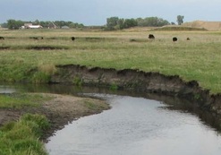
The Minnesota Pollution Control Agency
(MPCA) and the local Missouri River Basin work group are recommending a number
of actions to restore and protect water bodies in the Missouri River Basin in southwest
Minnesota. Generally, most streams and lakes in the basin fail to support
swimming or fishing. Stream
bank erosion and stormwater runoff degrade water quality with sediment that
clouds the water, excess nutrients that grow algae, and bacteria that can make
the water unsafe for swimming. These pollutants are also harmful to fish and
other aquatic life.
The basin includes the headwaters
of the Upper
Big Sioux, Lower
Big Sioux, Rock,
and Little
Sioux rivers. These watersheds lie in portions of six counties: Lincoln,
Pipestone, Murray, Rock, Nobles and Jackson. Leaving Minnesota they flow into
Iowa and South Dakota. Leaving
Minnesota they flow into Iowa and South Dakota. Agriculture dominates land use,
with 80 percent in row crops and 11 percent pasture.
The MPCA and local partners have identified
a number of restoration strategies, as recommended in two reports that are open
for public comment through Oct. 25:
In the Missouri River basin,
recommendations include buffers along shoreland, stabilized stream banks, and
stormwater control projects. Agricultural practices include greater use of cover
crops, prevention of over-grazing of stream banks by limiting cattle access,
minimum or no tillage, temporary storage of water, and greater crop diversity.
Many groups are participating in
restoration and protection efforts, including watershed districts, soil and water
conservation districts, cities and several state and local organizations.
Individuals are always encouraged to get involved.
The MPCA encourages those interested in the
Missouri River Basin to review and provide feedback on the reports. Comments on
the reports should be submitted in writing by 4:30 p.m. Oct. 25, to Mark Hanson,
MPCA, 504 Fairgrounds Rd., Marshall, MN 56258, or sent by email to mark.hanson@state.mn.us.
Written comments must specify which report
you are commenting on, include a statement of your interest in the report, and
the action you wish the MPCA to take, including specific references to sections
of the draft report you believe should be changed. You must state the specific
reasons for your position.
|
The MPCA recently released its proposed changes to Minnesota rules that are meant to protect wild rice from certain types of pollution.
The proposed rule changes take into account the newest evidence about how sulfate and sulfide affect wild rice. Peer-reviewed agency research begun in 2011 found that:
- Sulfate in wild rice waters enters the sediment in which wild rice is rooted, and bacteria convert it into sulfide.
- Higher levels of sulfide in the sediment create an environment that reduces wild rice growth and survival over time.
The existing rule (or standard) limits sulfate to 10 milligrams per liter in water used for the production of wild rice. However, the MPCA’s new research indicates that sulfide in the sediment in which wild rice grows is the pollutant of concern. The proposed rules are designed to limit sulfide to 120 micrograms per liter.
The sediment sulfide originates from sulfate in the water, but certain factors change the rate at which sulfate is converted to sulfide in the sediment. Most significantly, higher levels of iron in the sediment can lead to less sulfide, and higher levels of organic carbon can lead to more sulfide. So while sulfate may create conditions that negatively affect wild rice, no single level of sulfate can be protective of wild rice in all bodies of water.
The rule proposal sets up a process to identify the level of sulfate that is protective for each wild rice water: The MPCA will collect sediment samples in wild rice stands and measure iron and organic carbon concentrations, and then enter the data into an equation to determine the numeric sulfate standard for that wild rice water. The agency will use the wild rice rules to evaluate facilities that discharge to wild rice waters, such as wastewater treatment plants, mines, and industrial facilities, and, over time, determine if they need additional permit limits to protect wild rice.
Public comment period now open
The MPCA is now accepting public comments on the proposed rules. Public hearings on the rule proposal are scheduled at locations around the state between Oct. 23 and Nov. 2. Comments will be accepted until at least five days after the last public hearing. (The final comment deadline is determined by the hearing judge.)
Comments must be submitted to the Office of Administrative Hearings via the web (https://minnesotaoah.granicusideas.com/discussions), by mail (Office of Administrative Hearings, P.O. Box 64620, St. Paul, MN 55164), or in person (600 N Robert St., St. Paul, MN). In your comments, you must include your name and address and identify the portion of the proposed rules you are commenting on, your support of or objection to it, and any change you are proposing.
To view all rule-related information visit: www.pca.state.mn.us/water/protecting-wild-rice-waters.
|
The U.S. Environmental Protection Agency recently approved Total
Maximum Daily Load study reports for the following watersheds. These studies
determine the total amount of a pollutant that a water body can receive on a
daily basis and still meet water quality standards.
Elm Creek: Several lakes and streams impaired
Parts of the Elm Creek watershed in the Twin Cities are
polluted as a result of agricultural runoff, stormwater runoff, and streambank
erosion, according to the TMDL
study by the MPCA and its partners. In several lakes and
streams, the pollution is significant enough to inhibit recreational activities
like fishing and swimming, to harm aquatic insects and fish, or to cause high
levels of bacteria that can be harmful to human health.
The Elm Creek watershed
in Hennepin County includes the cities of Champlin, Corcoran, Dayton, Maple
Grove, Medina, Plymouth and Rogers. Diamond Lake, Rice Lake, Fish Lake, Rush
Creek and Elm Creek are some of the water bodies within the watershed that are
considered “impaired,” or polluted. The MPCA, Elm Creek Watershed
Management Commission, Three Rivers Park District, and local groups are
recommending a number of actions to restore and protect water bodies in the Elm
Creek Watershed.
The MPCA approved the Watershed
Restoration and Protection Strategies (WRAPS) in
December 2016.
Nemadji River: Mixed
water quality results
The MPCA and partners found mixed water quality test
results for 30 waterbodies in northern Minnesota’s Nemadji River watershed, according to the TMDL report.
The Nemadji system is well known as the primary source of
sediment to Lake Superior from Minnesota’s North Shore streams. Restoration
activities lie ahead for 12 of 22 streams and two of eight lakes that do not
meet water quality standards for sediment, bacteria and nutrient levels, and
fish and invertebrate populations. The remainder meet all criteria for healthy
conditions and future actions will focus on protecting them from future
impairments.
The MPCA, Nemadji River Watershed stakeholders group, and Carlton
County Soil and Water Conservation District have recommended several related
restoration and protection actions to help maintain or improve the watershed’s
water quality. These include assessing culverts and septic systems and
replacing those found ineffective, limiting livestock/animal stream access,
streambank and lakeshore buffer improvements, restoring natural stream channels
where appropriate, improving forestry management, and maintaining natural hydrology.
The MPCA approved the Nemadji
WRAPS in June 2017.
Sand Hill River: Waters
impaired by several pollutants
Some lakes and streams in
the Sand Hill River watershed are polluted with excess
nutrients including phosphorus, bacteria, sediment that causes cloudiness in
the water, and low dissolved oxygen, according to the TMDL
report. In some areas, the pollution is severe enough to be
harmful to aquatic insects and fish.
The Sand Hill River
watershed drains 395,249 acres in northwestern Minnesota. The watershed
includes portions of Polk, Norman and Mahnomen counties.
Because 85% of the watershed
acreage is used for agriculture, many farming activities are the sources of
pollution and changes in practices are needed to restore water quality.
Extensive drainage has changed the watershed’s hydrology, including
contributing to flooding that leads to stream and ditchbank erosion. Runoff
also carries pollutants to lakes and streams in the watershed.
Strategies to restore
waters include holding back water to prevent runoff and flooding, buffers along
ditches, better managing fertilizer and manure, fixing septic systems, and
keeping livestock out of streams.
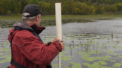
 Did you know the fish and bugs, or biological communities,
living within Minnesota’s rivers and streams can tell a story about the quality
of the water and habitat within them? Each year the MPCA’s Biological
Monitoring Unit samples biological communities from about 200-400 sites on
rivers, streams, and ditches throughout Minnesota. These waterways range in size from a few feet wide to
large main-stem waterways, such as the Mississippi or Minnesota river. So, how
are the biological communities sampled, and what can they tell us?
Fish are sampled once per site from
June through September, using electrofishing methods where
an electric current is placed into the water, temporarily stunning any fish
within range of the current. MPCA crews
use a net to collect the fish, regardless of size, from the smallest minnows to
the largest game fish, and then place them into a tub of water. Fish are
separated by species, and counted, measured, weighed and released back into the
stream. Depending on stream width and depth, a variety of electrofishing
methods are used to maximize sample efficiency and quality. For small streams,
a sampler walks through a stream carrying a shocker wand and backpack that
houses a battery. For large rivers, samplers use boats with shocking equipment
attached.
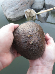
Bugs, or macroinvertebrates, are sampled once from August
through September at the same locations where fish are sampled. A specialized net is used to take 20 individual samples from the most
dominant habitat types: rocky areas, instream vegetation, undercut banks, woody
debris, and/or and piles of leaves in the stream. The macroinvertebrates are
placed in a jar with alcohol to preserve the sample and
brought to a laboratory for identification.
Fish and macroinvertebrates are a great indicator of stream
health because some species are sensitive to disturbances. This sensitivity
allows biologists to assess where issues may exist based on the communities
present. For example, some fish are very tolerant of low dissolved oxygen levels
while others are extremely sensitive to low dissolved oxygen levels. Looking at
biological samples, habitat assessments, and water chemistry samples can
provide a good picture of the stream health. Examples of potential problems may
include low dissolved oxygen, high sediment concentrations, agricultural or
industrial runoff, or lack of habitat. The information gathered can guide
watershed partners to restoration or protection efforts.
For more information:
|

Gov. Mark Dayton will wrap up his town hall meetings next
week as part of his "25 by 25" clean water initiative, which aims to
improve water quality in Minnesota by 25% by 2025. The meetings offer
Minnesotans an opportunity to discuss the water quality challenges facing their
communities and our state, learn from experts, and engage with policymakers.
The meetings build on the momentum from Dayton’s “25 by 25” Water Quality goal
proposal, announced earlier this year.
The final
town hall meetings will be Oct. 4 at Diamondhead Education in Burnsville and
Oct. 5 at Stillwater High School. Registration will open at 6 p.m. with the
meetings running 6:30-8:30 p.m.
|
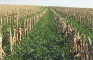
The Chippewa 10% Project, called “C10%,” strives to increase
continuous living cover in the Chippewa
River watershed by 10%, from 24 to 34%. By the numbers, that means
increasing living cover from 320,000 acres to 453,000 in this west-central
Minnesota watershed of 1.33 million acres. This project consists of several
partners working to improve water quality while engaging the community to find local
approaches that also support farm profitability.
Continuous
living cover can consist of perennial plants or a careful overlapping of
annual and cover crops. This strategy is a proven way to reduce runoff while
improving soil health.
For the Chippewa watershed, living cover will also mean
decreasing pollutants in water resources. The Chippewa River Watershed Project
operated five water quality and flow monitoring stations from 1998-2012. These stations
monitored streams in five different sub-watersheds. Each area differed in land
use. The water monitoring found correlations between land use and water
quality. Based on the monitoring data and research, the partners determined
that increasing living cover by 10% would decrease nitrogen and total suspended
solids enough to meet local water quality goals.
The C10% is based on the idea that rural landscape changes begin
with farmers and landowners, and include the entire community. Its partners
work together to find locally driven solutions. The partners engage with
farmers and their communities through various initiatives.
One initiative is the Cover Crop/Soil Health Network. Farmers
and ranchers in the Chippewa River watershed are monitoring their soil’s
response to cover crops and experimenting with different species, planting
methods and timing. Network members meet each winter to talk about what they
tried, what worked and didn’t, and generate new ideas. They also meet annually
with soil scientists to examine soil test results and what they reveal about
each farm.
The MPCA has played an important role in developing C10%.
Starting in the late 1990s and continuing today, MPCA and federal grants were
critical to establishing the Chippewa River Watershed Project, one of the
founding partners. These grants, along with technical and logistical support
from MPCA staff, developed the water monitoring that formed the basis for C10%.
This in turn has led to increased interest and funding from other partners.
For more information, see the Land
Stewardship webpage on the project.
|
|