May 2016
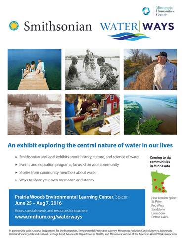 The Prairie Woods Environmental Learning Center, Spicer, in cooperation with the Minnesota Humanities Center, will host the opening Water/Ways, a traveling exhibition from the Smithsonian's Museum on Main Street program. It will run June 25 through Aug. 7. The MoM is a national/state/local partnership to bring exhibitions and programs to rural cultural organizations. The exhibition will tour six communities in Minnesota from June 25, 2016 through April 9, 2017.
In addition to the exhibit at Prairie Woods, local sponsors have been organizing related activities: June 25-Water/Way exhibit grand opening; June 29-Kandiyohi County Historical Bus Tour; July 2-Okee Dokee Brothers concert at PWELC. Special programs with expert speakers are being planned for Thursdays.
Water/Ways reveals the central nature of water on our lives by exploring how Americans use water, how water unites communities, how water affects every element of life, and how Americans care for our water and protect this valuable resource.
Upcoming Water/Ways schedule:
Aug. 13-Sept. 25: St. Peter, Nicollet County Historical Society.
Oct. 1-Nov. 13: Red Wing, Goodhue County Historical Society.
Nov. 19-Jan. 1, 2017: Sandstone (Pine County), Audubon Center of the North Woods.
Jan. 7-Feb. 19, 2017: Lanesboro (Fillmore County), Lanesboro Arts.
Feb. 25-April 9, 2017: Detroit Lakes (Becker County), Becker County Historical Society.
June 25 grand opening schedule:
-
9:30-10 a.m.: Guests arrive at Prairie Woods Environmental Learning Center in Spicer.
-
10 a.m.: Welcome. Minnesota Humanities Center and Prairie Woods.
-
10:15-10:45 a.m.: Speakers TBA.
-
10:45 a.m.: Ribbon cutting announcement, Minnesota Humanities Center.
- 10:50-11 a.m.: Official ribbon cutting and photo opportunity for Water/Ways exhibit.
-
11-11:30 a.m.: Reception, cake and punch.
- Water/Ways exhibit open to the public until 5 p.m.
Back to top
|
 The Middle Fork Crow Watershed District received grant funds to establish the Adopt-a-Storm Drain program in four area communities. In Atwater, Spicer, New London, and Willmar, residents can sign up online at www.adopt-a-drain.org to ‘adopt’ storm drains in their neighborhoods. The project is among activities relating to the Smithsonian WaterWays exhibit coming to Kandiyohi County June 25-Aug. 7 at Prairie Woods Environmental Learning Center.
The Adopt-a-Storm Drain program started as a project of the Capitol Region Watershed District in St. Paul. The internet program was created by Hamline University. Expansion to Kandiyohi County occurred with a grant received by the Middle Fork Crow River Watershed District in Spicer. After
registering, citizens can select their city from a drop-down menu and insert their address. A
map of their neighborhood will appear and populate with icons of storm drains.
Back to top
|
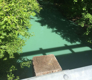 An apparent blue-green algae bloom appeared in Eagle Lake north of Willmar on Saturday, May 21, and downstream in Hawk Creek. The report came from local residents, one of whom took a photo
showing a coating of a bright green substance on the surface of Hawk Creek
about a mile from the lake. A resident on the south shore of Eagle Lake also
contacted the Dept. of Natural Resources Saturday about the algae bloom.
After seeing the photo, Steve Heiskary, a lake water quality expert with the MPCA, checked the weather
conditions for May 21 and reviewed data of Eagle Lake water quality. “This is a blue-green bloom and a rather severe one,” Heiskary said. “The
conditions were well within the range in which blue-green algae can prosper. There are ample nutrients in the lake to drive blue-green blooms.”
The resident also checked
the outlet of Hawk Creek into nearby Swan Lake, and observed a large green mat
of algae on the surface spreading about 100 feet. Eventually, it would be
absorbed and diluted in the lake. By Monday, the water from the Eagle Lake
outlet and in Hawk Creek had returned to its normal clarity. The MPCA will be issuing a news release statewide informing the public about the possibility of harmful algal blooms in some lakes during summer months. (May 21 photo of Hawk Creek on 15th Street NE bridge submitted by reporting citizen.)
Back to top
|
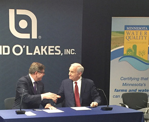 Gov. Mark Dayton and Land O’Lakes, Inc. President and CEO Chris Policinski, announced a new public-private partnership to protect and improve water quality across Minnesota. This is the first of its kind in the nation, partnering the state with Land O’ Lakes and local farmers across Minnesota to improve water quality stewardship standards on their farms. Land O’ Lakes will work to expand participation in the Minnesota Agricultural Water Quality Certification Program through their ag retail network across Minnesota. With 2015 annual sales of $13 billion, Land O'Lakes is one of the nation's largest cooperatives.
The Minnesota Agricultural Water Quality Certification Program is a voluntary program for farmers and landowners to take the lead in implementing conservation practices that protect and improve the state’s water resources. Since its inception in 2014, the program has certified more than 150 farms totaling more than 83,000 acres. Together, the program keeps over 6.5 million pounds of sediment out of our rivers, while saving nearly 9 million pounds of soil and 4,500 pounds of phosphorus on farms, each year. Photo: Land O' Lakes CEO Chris Policinski (left) and Gov. Mark Dayton shake after signing the agreement. Full story.
Back to top
|
 The Heron Lake Watershed District (HLWD) recently hosted a tour of projects installed with a $122,000 Environment and Natural Resources Trust Fund grant in 2013.
They included a biodetention basin,
multiple terrace projects, a bioretention basin, and a streambank
stabilization. The purpose of these projects was to reduce sediment and
nutrient loads into streams and lakes within the HLWD. All the projects
combined affected more than 300 acres and have an estimated reduction rate of
500 pounds of phosphorus and 550 pounds of Total Suspended Solids (TSS) per
year. The grant covered 75 percent of the
project costs, provided funding to continue water sampling at three watershed
sites to monitor grant progress, and financed newsletter expenses to promote an
education event.
Catherine
Wegehaupt, HLWD watershed technician, presented information about the grant, all
the projects that were installed, the total cost of the projects, and the
nutrient reduction achieved from installation. Stops included the Okabena Creek streambank stabilization
site, the Graham Lakes bioretention basin site, and the Fulda Lakes biodetention basin.
Back to top
|
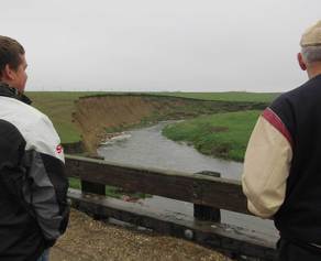
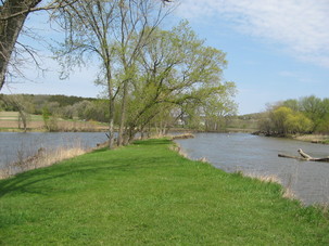 The MPCA, Yellow Medicine River Watershed
District, and local groups are recommending a number of actions to restore and
protect water bodies in the Yellow Medicine River Watershed. Photo: Confluence of the Minnesota River and Yellow Medicine River (right).
The
Yellow Medicine River Watershed Restoration and Protection Strategy (WRAPS)
report and Total Maximum Daily Load (TMDL) report are
available for public comment through June 15.
Generally,
most of the streams and lakes in the watershed do not safely or adequately
support swimming or fishing. Streambank erosion and stormwater runoff are
having a negative effect on water quality. Agricultural activities in the
watershed – the main use of land here – have resulted in runoff that carries
excess phosphorus, sediment and bacteria into bodies of water.
The TMDL report quantifies the pollutant levels, identifies the sources
of the pollution, and proposes ways to bring water quality back to an
acceptable level. The
WRAPS report identifies impaired water bodies and those in need of protection,
and identifies the actions needed to achieve and maintain water quality.
Many
groups are participating in restoration and protection efforts, including the
Yellow Medicine River Watershed District, Soil and Water Conservation
Districts, member cities and several state and local organizations. Individuals
are always encouraged to get involved.
The MPCA
encourages those interested in the Yellow Medicine River Watershed to review
and provide feedback on the reports. Comments on the reports should be
submitted in writing by June 15 to Michael Weckwerth, MPCA, 504 Fairgrounds Rd.,
Marshall, MN 56258 (507-476-4267).
Back to top
|
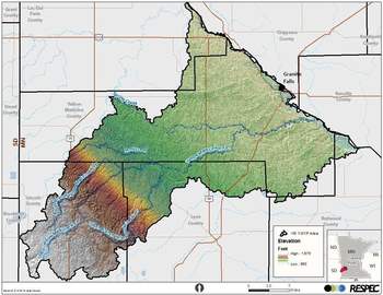 The Yellow Medicine River Watershed draft One Watershed One Plan (1W1P) document is on public notice until July 15. The watershed was selected by the Minnesota Board of Water and Soil Resources (BWSR) as one of the five pilot areas for 1W1P. This allows counties to transition from county-based water management planning to watershed-based planning.
The planning area includes a drainage area of more than 438,400 acres. The Lac qui Parle, Lincoln, Lyon, and Yellow Medicine County Boards and their respective SWCD Boards, along with the Yellow Medicine River Watershed District and Area II Minnesota River Basin Projects, have entered into a 1W1P Memorandum of Agreement.
Because four of the five counties in the Yellow Medicine Watershed had plans that were expiring by the end of 2015 and a Watershed Restoration and Protection Strategy (WRAPS) was being completed for the watershed, SWCD members determined that the 1W1P pilot project was consistent with their goals and that the Yellow Medicine Watershed was the best candidate for the pilot project. The pilot project will be adopted throughout the rest of the Area II Minnesota River Basin Project planning area for a regional approach for watershed-based management. A public hearing on the draft plan is scheduled for 7 p.m., Monday, Aug. 1 at the Southwest Sportmen's Club in Minneota. Written comments on the draft plan should be sent to both Kerry Netzke, Area II executive director; and Jason Beckler, BWSR board conservationist.
Back to top
|
 Reports on protecting and restoring the Cannon River watershed are now open for public comment.
This area in southeastern Minnesota provides high quality streams for trout
fishing and other recreation. However, some parts of streams suffer from
bacteria levels that may make the water unsafe for swimming, soil and sediment
that cloud the water, phosphorus levels that cause frequent algal blooms, and
nitrate levels that may stress aquatic life like fish.
The Minnesota Pollution Control Agency is accepting comments on
the reports through June 23.
The
first report is a Total
Maximum Daily Load (TMDL) study, which determines the
maximum amount of pollutants that a water body can accept and still meet standards.
The study incorporates water quality data from the past 10 years, fish surveys,
stressor identification investigations, stakeholder input, and other
information.
For
the lakes and streams in the watershed to meet water quality standards, the
reductions in pollutants need to come from both point sources, such as
wastewater from a city, and nonpoint sources such as sediment that washes from
the landscape during storms. The report
outlines strategies to reduce pollutants, such as agricultural practices to
reduce runoff and erosion, manure runoff controls, sewer system upgrades,
limits on wastewater discharges, and urban stormwater controls.
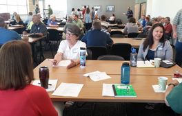
The second report
open for comment is on Watershed Restoration and Protection Strategies (WRAPS) for the Cannon River. This report summarizes all water
quality work in the watershed. A year-long stakeholder process culminated in a table of
implementation strategies to help restore areas where pollutants violate
standards and help protect those areas meeting standards. This table and accompanying tools for
prioritizing management efforts are included in the WRAPS Report.
Many groups are participating in
restoration and protection efforts, including the Soil and Water Conservation
Districts, cities in the watershed, the Cannon River Watershed
Partnership, and several
state and local organizations. Individuals are always encouraged to get
involved. (Photo: Cannon River WRAPS meeting).
Back to top
|
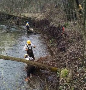 A
stream restoration project to improve trout habitat in Spring (Hinderman) Creek
near State Highway 4 north of Sleepy Eye is nearly complete. Project partners
have designed and constructed a stream restoration project that will reduce
erosion and provide additional habitat for trout and other species.
“Not
only will this project improve trout habitat, it will improve water quality,”
said Garry Bennett, DNR area hydrologist with the Division of Ecological and
Water Resources. “The reduced erosion and sedimentation from a more stable
stream will pay dividends for water quality over the long term.” DNR Fisheries
stocks 300 adult brown trout and 300 adult rainbow trout each spring to provide
a unique fishing opportunity to the region. A 66-foot-wide easement along both
sides provides access for anglers.
The DNR allocated about $300,000 to
improve the form, function and stability of Spring Creek. Rock vanes and
rock cascades were strategically placed to provide grade control and yet allow
for fish passage. Eroding banks were stabilized while maintaining a natural
look and feel to the stream. Bioengineering practices included installing large
root wads and cedar trees to improve bank stability and reduce erosion.
Because
of the many active springs within the project area, DNR staff and construction
crews took special precautions to protect these natural features. The cool
spring water is what creates conditions for the trout to thrive. Project
construction took place during the winter of 2015-16 and native plantings will
be completed by June 2016.
The project was funded through the Conservation
Partners Legacy grant program from the Outdoor Heritage Fund, and administered by Brown County. Additional
partners included surrounding landowners, Wenck Associates, Minnesota Native
Landscapes, and Minnesota Conservation Corps. (Photo: John Knisley, Brown County Planning and
Zoning.)
Back to top
|
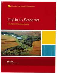 How water is managed in and near fields has a big influence
on the condition of Minnesota streams and rivers. That is a conclusion of “Fields to Streams: Managing Water in Rural Landscapes”,
a University of Minnesota Extension bulletin. Released earlier this year as a downloadable
pdf, Fields to Streams is now also
available in print.
The first part explains the role of geology, changing
rainfall, and land management practices in altering the amount and timing of
runoff reaching and shaping streams. Increased flows are eroding and widening
stream and river channels and sending more sediment downstream in recent
decades.
The second part of Fields to
Streams describes practices for managing crops, drainage systems, and surface
runoff to reduce peak flows and lessen the amount of streambank, bluff, and
ravine erosion. It concludes with considerations for working together at the
local watershed scale to improve streams through water management. The bulletin
relies on graphics and brief explanations of research findings for both
landowners and conservation professionals. Go to z.umn.edu/FieldsToStreams to
download the free pdf or to order a print copy.
A webinar on using Fields to Streams in conversations with
landowners for farm conservation and watershed planning is scheduled for July
20, 10-11 a.m. by MASWCD (MN Association of Soil and Water Conservation
Districts). Check their website at http://www.maswcd.org/
for the link.
Back to top
|
The
Minnesota Association of Soil and Water Conservation Districts, in partnership with the U of M Extension and the
Minnesota Board of Water and Soil Resources, launched a New
Leadership Institute for Soil and Water Conservation District board members and
staff. The
mission of the MASWCD Leadership Institute for Problem Solving
is to strengthen the leadership capability of board members and staff while
addressing current issues that lead to more effective conservation delivery
throughout the state.
The
policy topic being addressed is technology; specifically on
infrastructure, district operations, and landowner
services. Areas
of study for the one-year cohort leadership institute include: Visionary
Leadership; Communication; Problem Solving; Balancing Ethics, Economics and the
Environment; Civic Leadership, and Organizational Leadership. For additional
information on the MASWCD Leadership Institute contact the MASWCD office at
651-690-9028. Minnesota Association of Soil and Water Conservation Districts, www.maswcd.org.
Back to top
|