September 2015
 The Heron Lake Watershed District (HLWD)
recently completed a four-year project to inventory feedlots in the West Fork
Des Moines River (WFDMR) watershed. The project, funded by a 319 grant, was
part of the implementation plan of a Total Maximum Daily Load study for the
WFDMR and Heron Lake. "The watershed is plagued with waters impaired with
high E.coli levels," states the report. "Runoff from feedlots is a
major contributor to E.coli in surface waters."
The inventory helps to identify sources of
bacteria and nutrient loading from feedlots. HLWD and project partners
will use the inventory as a basis for grant applications. It is hoped that this
will lead to cost-share and other assistance for improvements to
feedlots. "Open feedlots that are non-compliant with high
indexes should be targeted for implementing feedlot fixes. Reducing open
feedlot runoff from these sites will be the most beneficial in reducing E.coli
levels in impaired streams," states the report.
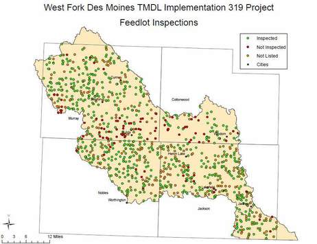
More than 80% of the feedlots were
inspected: 44 in Cottonwood County, 142 in Nobles County, 190 in Jackson
County, and 216 in Murray County for a total of 592. MinnFARM (Minnesota Feedlot Annualized
Runoff Model) was used to determine compliance for open feedlots and assign a
priority index. Results showed that the majority of open lots inspected were
not compliant. See a summary of the report on the HLWD website.
Back to top
|
Henderson, Minn. – The Minnesota River Congress organizing
committee approved of filing with the Minnesota Secretary of State for
not-for-profit corporate status. This would establish the Congress as a formal
organization with governing structure and bylaws.
The organizing committee met Sept. 10 in Henderson to
prepare for the fifth Congress event scheduled for Nov. 12 in New Ulm. Creation
of the Action Board governing the Congress will be a primary goal.
The Action Board would be composed of one representative
from each of the basin’s 13 watersheds, 14 people from sectors including
business, agriculture, recreation, and local government, and six state agency
staff. It will set policy, goals, and objectives for the Congress.
Congress organizers will be recruiting candidates for the
Action Board. The one-page application form asks for watershed residence and
sector, and a brief statement of interest and qualifications. Action Board
membership will be named at the Nov. 12 Congress.
The Action Board will then name a management committee to
handle administrative tasks, such as finance, communications, membership, and
legal matters. The goal is to have the Action Board and management committee
established by year’s end.
The Nov. 12 Congress event will also address the proposed
legislation creating a Minnesota River Commission. The Congress organizing
committee had supported the bill, but a formal endorsement at the July 23
Congress meeting was tabled.
The Congress is cited in the bill (SF 2204) as serving in
a citizen advisory role. An updated version of the bill will be made available
for review prior to the Nov. 12 event.
Congress organizers believe there is a need for a
basin-wide organization following the dissolution of the former Minnesota River
Board. Action board application forms are available by contacting Scott
Sparlin, sesparlin@gmail.com. More
information about the Minnesota River Congress is available at: www.watershedalliance.blogspot.com/.
Back to top
The Minnesota Pollution Control
Agency (MPCA) received $2 million less than requested in legislative funding
this year for the fiscal year 2016-17 biennium, leading to delays in some
watershed work. The agency was on track to monitor and assess Minnesota’s 80
major watersheds on a 10-year cycle. That timeline now shifts to an 11-year
cycle because of reductions in summer help, full-time staff, and aid to local
partners.
Less
funding means less monitoring will be done each year. Also, the agency has
fewer staff members and contactors to work on developing strategies to restore
and protect water bodies.
Called the
watershed approach, the cycle consists of:
- Monitoring and assessing rivers and lakes in
major watersheds to see if they meet water quality standards.
- Identifying stressors to water quality and
conditions fostering healthy waters.
- Developing Watershed Restoration and
Protection Strategies (WRAPS) to restore and protect water bodies.
- Implementing projects and activities to
restore and protect water quality.
Cycles
are staggered with an average of 8 watersheds beginning a new cycle each year.
With the funding shortfall, the following watersheds in the Minnesota River
basin will see a delay of 1 to 2 years in monitoring and 6 months to 1 year for
their strategy development:
- Redwood River
- Cottonwood River
The following watersheds in
southern Minnesota will see a delay of 6 months to 2 years for their strategy
development (WRAPS):
- Watonwan River
- Minnesota River - Mankato
- Des Moines River
- Lower Minnesota River
- Minnesota River Headwaters
- Lac Qui Parle River
With this plan, the MPCA is
striving to minimize disruption to local projects and to complete the first
cycle in all 80 watersheds before starting the second one.
For more
information about the watershed approach, visit the agency website or contact Glenn Skuta,
statewide water monitoring supervisor, at 651-757-2730.
Related
information:
Back to top
|
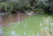
Phosphorus in
lakes and nitrates in streams are a top concern in the Cannon River watershed,
according to intensive water monitoring and assessment by the MPCA and Cannon
River Watershed Partnership. Other concerns include bacteria in the water, soil and other
particles clouding the water, and mercury levels in fish.
High levels of nutrients that cause algal blooms are hurting
aquatic life and recreation in many lakes in this southeast Minnesota watershed.
Nitrate levels in four trout streams are high enough to violate the standard
for coldwater streams (the same standard is used for drinking water). Nitrates
are a concern because of karst areas in the watershed -- where the bedrock is
porous and pollutants can easily reach groundwater.
Few
of the water bodies studied in the Cannon watershed fully meet the swimmable
and fishable standards. The vast majority fail to meet standards all the time.
“People
have extensively changed the land in the watershed with farming, drainage,
building towns and applying fertilizers, which have all taken a toll on lakes
and streams. While much has already been done in the Cannon watershed,
additional work is needed to restores its lakes and streams,” the report concludes.
Bright
spots in the watershed include five lakes that are fully supportive of water
quality standards: Beaver, Dudley, Fish,
Kelly, and Roemhildts. These lakes need protection strategies to maintain their
high quality.
The
Cannon River Watershed Partnership is holding a series of meeting to gather input
on developing the Watershed Restoration and Protection Strategies for the
Cannon. See the details on the partnership’s
website.
For
more information on the watershed’s intensive monitoring results, visit the MPCA
website.
Photo
above: The Wolf-Cannon river confluence shows the problems of high sediment and
nutrient levels.
Back to top
|
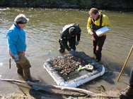
The MPCA is asking for your data to help assess the condition of
lakes and streams and build a national database of water quality.
The MPCA
is specifically interested in these southern Minnesota watersheds because we
will be determining whether these water bodies meet state water quality
standards in early 2016:
- East Fork Des Moines River
- Lower Des Moines River
- Lower Minnesota River
The MPCA is also looking for
data on the Minnesota River from the headwaters to the Mississippi River.
If you
have data from outside a priority watershed or one of these areas, the agency
will also accept it.
Deadline:
Submit project, lab, and field data now through Nov. 2.
Deadline:
By Dec. 15 you will need to review the data entered by the
MPCA.
Find out
more on the MPCA's surface water data website.
Your
role in collecting these data is important to Minnesota’s effort to identify
impaired waters, as well as those waters in need of additional protection. Thank
you for your help.
For more
information on submitting data:
- Nancy Flandrick, 651-757-2361 (St. Paul,
Duluth, Rochester, and Mankato regional offices)
- Jean Garvin, 651-757-2378 (Brainerd, Willmar,
Marshall, and Detroit Lakes regional offices)
Back to top
|
 The 2015 Green Lands Blue Waters
Conference will be held Nov. 3-4 on the third floor of the Coffman Memorial Union
at the Minneapolis-East Bank Campus of the University of Minnesota.
The theme
this year, "Buffers and Bridges, Farms and Cities,” responds to the
growing interest in Continuous Living Cover farming sparked, in part, by Minnesota’s new buffers
law, the Des
Moines Water Works lawsuit, and the larger than expected dead
zone in the Gulf of Mexico this summer.
Conference
speakers include:
- Wes Jackson,
founder and president of The Land Institute
- Joan
Nassauer, professor of Landscape Architecture, School of Natural Resources and
Environment, University of Michigan
- Don Wyse, professor
of Agronomy and leader of the Forever Green Initiative, University of Minnesota
- John Jaschke,
executive director, Minnesota Board of Water and Soil Resources
- Wayne Anderson,
Minnesota Pollution Control Agency and Mississippi River Gulf of Mexico
Nutrient Task Force
- Mark Tomer,
USDA Agricultural Research Service, National Laboratory for Agriculture and the
Environment, Ames, Iowa
- John Baker,
USDA Agricultural Research Service and adjunct professor in the Department of
Soil, Water & Climate at the University of Minnesota
Registration
for the conference, which offers Continuing Education Units, is available online.
|
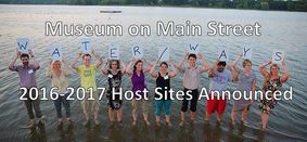
Six Minnesota communities have
recently been selected by the Minnesota Humanities Center to host Water/Ways,
a new traveling exhibition and community engagement tool from the Smithsonian:
- Prairie
Woods Environmental Learning Center (New London-Spicer), June 25 – Aug. 7,
2016
- Nicollet
County Historical Society (St. Peter), Aug. 13 – Sept. 25, 2016
- Goodhue County Historical Society
(Red Wing), Oct. 1 – Nov. 13, 2016
- Audubon
Center of the North Woods (Sandstone), Nov. 19, 2016 – Jan. 1, 2017
- Lanesboro
Arts (Lanesboro), Jan. 7 – Feb. 19, 2017
- Becker County Historical Society
(Detroit Lakes), Feb. 25 – Apr. 9, 2017
Water/Ways will focus on how Americans use water, how water unites
communities, how water affects every element of life, and how Americans care
for our water and protect this valuable resource for the future.
Each local host community will use
the national water story in the Smithsonian exhibition as a jumping off point
to tell their local water stories. Events and programs will accompany the
exhibit, to create a rich set of exhibits, stories, conversations, and new
relationships around water.
The Water/Ways project is meant to bring wide-ranging organizations
together to learn and discuss an issue that is central to community. If you
live in or near one of the host cites, consider how your business, faith
community, school, lake association, or nonprofit could help with creating accompanying
programs and events during the exhibition. Contact the local host organization
(linked above) to get involved.
|
 Jon Morales joins Middle Fork Crow staff
Jon Morales is the new hydrologic technician with Middle Fork Crow River Watershed District. He graduated in 2009 from the U of M-Duluth with a degree in environmental studies. While there he worked with the Center for Sustainable Community Development studying and promoting community wind development. After graduation he worked in Yellowstone National Park GIS department to develop a hydrological survey of Grayling Creek to improve native fish populations. Most recently he worked at Prairie Woods Environmental Learning center as an educator, coordinator for the Youth Energy Summit Program, and
building and grounds steward.
|
The Minnesota Department of Natural Resources has released updated wetland map data for 36 counties in southern Minnesota. The newly-released data are the first updates to the National Wetlands Inventory (NWI) for southern Minnesota. The new data cover a 23,900 square-mile area. A total of 49 Minnesota counties now have updated NWI data, including the 36 in southern Minnesota and 13 previously released counties in east-central Minnesota.
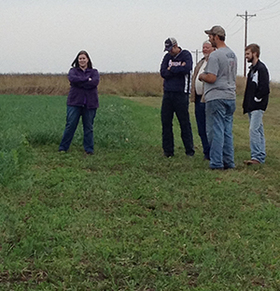 Hawk Creek staff at cover crop event
The Hawk Creek Watershed Project staff were among visitors to the Steven Spanier farm southwest of Belgrade for a cover crop field day Sept. 25. Working with Kandiyohi County NRCS, Steven has planted a cover crop cocktail of six to seven plant species on three acres to use as educational
purposes. Several of the mixes are specifically for grazers and others
are for promoting soil health and erosion control. The Renville County NRCS also is reportedly planning a cover crop field day sometime in November. Test plots are located on land of Hawk Creek project field technician Dean Dambroten, and SWCD board member Kathryn Kelly. Spanier built a home-made planter that can plant cover crop seeds in standing corn up to six feet tall (Photo below). Details will be announced later. Photo: Steven Spanier (in gray shirt); Hawk Creek project staff Heidi Rauenhorst (left), Jordan Austin (right), and Dean Dambroten (second from right).
|
 Back to top
|