|
|
News from the Minnesota Geospatial Information Office
|
|
|
|
Two Governor's Certificate Awards for Exemplary Geospatial Projects
Minnesota Governor's certificates were presented to two exemplary geospatial projects at the MN GIS/LIS Conference in Bemidji, Minnesota, October 13, 2022.
Nominations for these certificates are reviewed and recommended by the Minnesota Geospatial Advisory Council’s Awards Committee. For more information on both projects, see the GAC Awards webpage.

1. COVID-19 Testing Locations and Vaccine Finder web mapping applications
The Testing Locations and Vaccine Finder applications, created rapidly by cross-agency teams during the height of the pandemic crisis, provided life-saving information to the general public. The sites allow vaccine and testing providers to easily add, modify, and remove their own vaccination and testing locations from the maps using a simple form. For the public user, the tools transparently assist with finding conveniently located sites that meet their specific needs.
The award was presented to:
- Metropolitan Council
- Minnesota Geospatial Information Office
- Minnesota IT Services partnering with Minnesota Department of Revenue
- Minnesota IT Services Application Development
- Minnesota Department of Human Services
- Minnesota Department of Health
- Minnesota IT Services partnering with Minnesota Department of Health
|
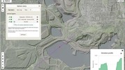
2. Minnesota Natural Resource Atlas
The Minnesota Natural Resource Atlas makes Minnesota’s spatial data accessible to everyone, regardless of experience. This free, online interactive mapping tool is paired with more than 500 multi-disciplinary data layers covering ten categories, including water, infrastructure, environment, imagery and landcover. Users can view multiple data layers simultaneously, perform measurements, access data attributes, summarize data within a boundary unit, and print or share the maps they create.
The award was presented to:
- Natural Resources Research Institute (NRRI) - University of Minnesota Duluth
|

The Minnesota Geospatial Advisory Council (GAC) Archiving Imagery Workgroup is investigating best practices for archiving aerial imagery data. The workgroup is gathering an inventory of the types of imagery resources available across the state that would be suitable for archiving. (The group is not gathering resources to archive at this time; it is only compiling a potential inventory.)
The types of imagery being considered include:
- scanned air photos (e.g., TIFF, JPEG, SID)
- georeferenced / georectified image files (e.g., GeoTIFF, GRID)
- image services
- associated index maps
If your organization has aerial imagery, please fill out the Archiving Aerial Imagery Survey by Monday, November 28, 2022
Questions? Contact Karen Majewicz
|
Geo-Enabled Elections Report

As part of its final-year deliverables, the National States Geographic Information Council’s Geo-Enabled Elections project has released the 2022 State Election Director Report, documenting progress in the use of GIS technology in elections across the United States since the project’s inception in 2017.
Election directors from 28 states and territories were interviewed or surveyed for the report, providing details on advances in the integration of GIS in elections. Examples include a greater use of audits to verify voter lists, and a significant increase in real-time updates of voter addresses.
See NSGIC's press release for information on signing up for the project's email updates and on attending the 2022 Elections Geo-Summit on December 8, where the report’s findings will be discussed.
|
|
|
|
|
|
|