New high density lidar is coming to Minnesota!
Lidar Plan Updates
The Geospatial Advisory Council's 3D Geomatics Data Acquisition Workgroup and MnGeo are working towards the collection of new lidar elevation data for Minnesota. A Lidar StoryMap and the first draft of the Minnesota Lidar Plan were published in 2019 and both include maps of proposed acquisition areas.
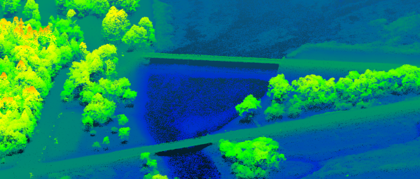
In Spring 2020, new high density lidar data was collected in Goodhue County. Additional lidar will be collected in Northeast Minnesota in Spring 2021. This represents the first phase of the State Lidar Plan.
Initial Funding and Partners
Cooperative partnerships are providing the funding for these collections. The US Geological Survey provides matching fund grants for lidar acquisition through its 3DEP BAA program (3D Elevation Program, Broad Agency Announcement).
In 2019, Minnesota received USGS 3DEP BAA grants for two areas:
1. NE Rainy Lake Block
-
Collection Time: Planned for Spring 2021
-
Quality Level: QL1 (Quality Level 1 has a high accuracy rating on a 0-3 scale)
-
Grant Requestors: The Geospatial Advisory Council's 3D Geomatics Data Acquisition Workgroup and MnGeo
-
Total project cost: $3,716,400
- USGS Contributions: $2,532,056 (68% of the total)
- 3DGeo Partner Contributions: $1,184,344 (32% of the total)
-
3DGeo Funding Partners: USFS Superior National Forest, Minnesota Department of Natural Resources Forestry, Office of School Trust Lands, USDA Natural Resources Conservation Service, DNR Fish and Wildlife, Koochiching County, Lake County, St. Louis County, Minnesota Department of Transportation, and MnGeo.
2. Goodhue County
-
Collection Time: Completed April 2020
-
Quality Level: QL0 (Quality Level 0 has the highest accuracy on a 0-3 scale)
-
Grant Requestor: Goodhue County
-
Funding Partners: Goodhue County, MnDOT, USDA NRCS and MnGeo
Details about when and how the data will become publicly available are still to be determined.
Additional Funds
USGS and NRCS recently added more funds which will expand the Spring 2021 collection in NE Minnesota to include part of the Lake Superior Block area.
The Data Acquisition Workgroup hopes to raise additional funds for another 3DEP BAA application to complete the Lake Superior Block and potentially acquire lidar in SE Minnesota.
Get Involved
The 3DGeo Committee invites you to participate in the lidar efforts. Upcoming meetings include:
- Lidar in NE Minnesota: Online, Thursday July 9 (1:00 - 2:30 pm)
- Lidar in SE Minnesota: Online, planned for later summer
To receive the calendar invitation for either meeting, please contact us at lidar@state.mn.us and let us know which one you'd like to attend.
|