April 7, 2021

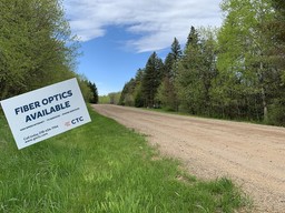
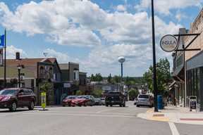
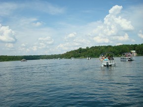
A state-of-the-art fiber-optic network in Ely’s downtown area is being installed by CTC and will bring affordable, reliable high-speed broadband service to 206 business and residential locations. The network is scheduled for completion by April 30. Iron Range Resources & Rehabilitation supported the project with a Community Infrastructure grant.
When completed, CTC customers in Ely will have access to:
- Internet speed of up to 1 Gig (1,000 Mbps), eliminating bandwidth limitations.
- Customized packages to select from that include fiber internet, managed WiFi and routing, and business voice.
|
“High-speed reliable internet is critical to Ely’s economy and quality of life, ” said Harold Langowski, Ely city clerk/treasurer. “The new fiber-optic network will eliminate connectivity barriers for the city’s small businesses, current and future remote workers and residents, and our real estate market.”
Langowski explained that according to several area realtors, broadband was quickly becoming one of the top questions by potential home buyers. Home values are being determined in part by the availability of high-speed internet. According to CTC the average increase in home value is 3.1% when fiber internet is connected to the home.
|
"Buyer and renter demand is growing in the region’s rural housing market. Second homes and cabins in the Ely area are seeing an increase in usage throughout the week or for longer weekends,” said Langowski. “This is in part is due to the pandemic’s impact of ushering in a growing number of remote workers across the state and nation. The importance of reliable broadband will only continue to grow.”
The city of Winton, Town of Morse, city of Ely, Incredible Ely, Ely Chamber of Commerce, ISD 696, Ely Economic Development Authority (EEDA) and local citizens formed the Ely Area Broadband Coalition (Ely ABC) to address broadband issues several years ago. In 2016 Ely was one of six communities to receive a $25,000 Blandin Broadband Communities (BBC) program grant. The group of Ely area partners utilized the grant to develop a feasibility study which served as a resource to improve local connectivity going forward. (The BBC was also supported by Iron Range Resources & Rehabilitation so that participating communities such as Ely had access to technical expertise, planning assistance and an opportunity to obtain financial resources to implement their broadband initiatives.)
|
“The multi-year process of bringing high-speed broadband to Ely has shown that community partnerships driven by a common goal can achieve great outcomes,” said Langowski. “The entire community and our EDA made broadband a priority, and it has been achieved through several phases. Having CTC as a partner in the new fiber network to our downtown area has been a huge benefit.”
CTC is a member-owned cooperative established in 1952 and based in Brainerd, with additional offices in Baxter and Crosby. It has 14,000 residential and business members, 73 employees, local support teams across northern Minnesota and provides services statewide. It originated as a telephone service provider and has since added television and internet services for homes, businesses, cabins and apartment buildings.
“Where there is high speed internet, there is economic growth and thriving families,” said Joe Buttweiler, CTC Director of Business Development. “CTC is very excited to welcome the people and businesses of Ely to our membership.”
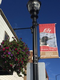
PHOTOS: Top two photos courtesy of CTC. Third photo courtesy of Lucy Hawthorne.
|
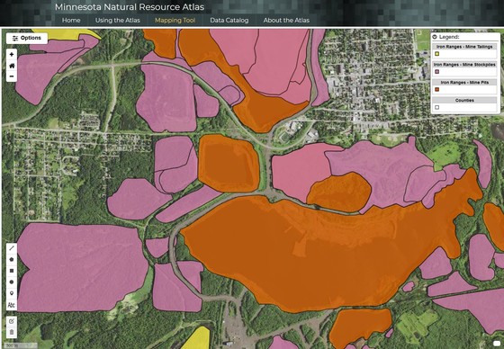 The Minnesota Natural Resource Atlas was recently developed and released to the public. It is a free online interactive mapping tool for natural resource planning, management and research in Minnesota. Users have access to a basic set of GIS tools for viewing, searching and manipulating mapped data. The project was led by Natural Resources Research Institute (NRRI) in partnership with University of Minnesota and Minnesota Sea Grant. Iron Range Resources & Rehabilitation supported the project through a grant to NRRI that helped pay for digital maintenance.
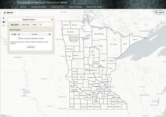
The Atlas is a tool unique to Minnesota that allows users to access over 380 data sets, conduct basic summaries, and view different combinations of spatial data. Information can be shared by exporting results and map images. Users may create unique .URLs with their extracted data that can be shared with others.
“User-friendliness and the ability for users to extract and share data with others were our two primary goals when developing the Atlas," said Will Bartsch, NRRI senior research scientist and Atlas project manager. “People without any mapping or GIS experience or knowledge can easily use this new tool. We engaged testing groups to ensure the best possible outcome for usability.”
Seven organizations conducted beta testing to evaluate the Atlas’s performance and ease of use: 1854 Treaty Authority, Fond du Lac Tribal Nation, Iron Range Resources & Rehabilitation, Lake County Soil & Water Conservation District, Lessard-Sams Outdoor Heritage Council, Minnesota Land Trust, and a private mining company.
The Atlas has many potential uses such as assessing natural resources in a particular area and identifying development opportunities in the mineral, forestry, water and tourism sectors. It can also help identify areas that should be considered for ecological restoration or enhanced protection.
“Local municipalities and organizations can use the atlas to help them in the decision-making process related to business and community development,” said Bartsch. “For example, soil and water conservation districts can evaluate land for conservation projects.”
Free training is available to local governments, tribal nations and other organizations. Learn more about the Minnesota Natural Resource Atlas.
Note: The Atlas project began in 2016 by a direct appropriation from the Minnesota State Legislature as part of the Minnesota Mining and Water Innovation Initiative. The initial phase encompassed 26 counties in northeastern and central Minnesota where mining takes place. A second appropriation was funded in 2019 through the Legislative-Citizen Commission on Minnesota Resources that is bringing the Atlas coverage statewide by June 2021.
Pictured above are a map of Iron Range mine pits and a Minnesota Natural Resource Atlas home page image.
|
 The new Veterans Riverfront Park is being built on an undeveloped parcel along the Little Fork River at the end of Cook’s main street. It is scheduled for completion in June. The park will pay tribute to all military branches and veterans, and provide an outdoor community space for residents and tourists. Iron Range Resources & Rehabilitation supported the project with a Culture & Tourism grant.
The park will feature memorials honoring the military, picnic tables, grills, a steel swing near the river bank, a flag pole, and a fence separating the park from the railroad.
“Creating a new outdoor community space will benefit our residents, families and businesses,” said Tammy Palmer, Friends of the Parks president. “People can share meals, gather with friends, exercise and play outdoors. The park had an abundance of support, and it was very important to the people of Cook to honor members of our community who have served and are still serving in the United States military.”
The Cook Veterans of Foreign Wars (VFW) and American Legion have a combined membership of 270 members. An estimated 2,000 veterans reside within a 40-mile radius of Cook.
|
The project is being led by local nonprofit Friends of the Parks. Other contributors include B.I.C. Realty, Canadian National Railway, Cook Lions Club, Cook Timberwolves Snowmobile Club, Cook VFW Post 1757, Lake Country Power, Timber Days Committee, Vermillion Vet Clinic and numerous private donations. Anyone wishing to donate to the park may email Tammy Palmer for information.
Email Danae Beaudette for Culture & Tourism grant information or call her at 218-735-3022.
|
Wabana Township in Itasca County recently developed a comprehensive plan to identify strategies and guide future decisions for land use, natural resources, township facilities and infrastructure. Iron Range Resources & Rehabilitation supported the project with a Development Partnership grant.
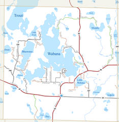
Wabana Township is 36-square miles and includes large tracts of public land, portions of the Chippewa National Forest, George Washington State Forest and 26 named lakes. It has about 500 year-round residents, 200 seasonal property owners and 200 households. Wabana owns and operates several facilities serving its residents and visitors including a town hall, picnic area, playground, ice rink, swimming beach, ball field, tennis court and cemetery.
|
Wabana Township is named in honor of Chief Waubena, a Native leader who dwelt in the area and was admired by early loggers and settlers. The area has a rich history of Native American culture, and “Wabana” in Ojibwe means “many bays.” The first white people were trappers and hunters who frequented the area for its bountiful natural resources. By 1865 logging companies entered the area, and Wabana Township was officially established in 1921. The area offered more than timber and ultimately became an attractive hub for tourism, hunting and fishing. Resorts sprang up along the lakes, and many remain operating today.
The lakes and lakeshore account for approximately 20% of the township’s area and provide economic input and recreational value through the resorts and tourism. The updated plan identified top priorities for the next decade including:
- Preserve natural resources and water quality of lakes.
- Provide township facilities and recreational opportunities.
- Ensure development occurs in an environmentally sustainable way.
|
“Wabana Township’s comprehensive plan serves as a business plan for the township to shape public policy and decisions moving forward,” said Whitney Ridlon, Iron Range Resources & Rehabilitation community development representative. “Having a current comprehensive plan can increase a rural community’s competitiveness for state, federal and philanthropic grants for projects related to infrastructure, broadband and recreation.”
Providing grants to help update comprehensive plans is part of Iron Range Resources & Rehabilitation’s commitment to preparing communities for the future. Email Whitney Ridlon or call her at 218-735-3004 for Development Partnership grant information.
Learn more about Wabana Township’s comprehensive plan.
|

Did you know?
A township is a unit of government patterned after the English town meeting developed to guarantee "grassroots" democratic participation. In Minnesota townships are the rural units of government closest to the people. Minnesota is first in the nation in the number of townships with 1,803 organized townships. Townships are about 36 square miles in area, and in Minnesota include populations from a few to over 10,000. Township governments serve approximately one-fourth of Minnesota’s population. (Source: Minnesota Association of Townships.) Iron Range Resources & Rehabilitation has 134 townships in its service area.
|
|