Welcome to the fourth and final issue of 2014. The Water Talk newsletter is published electronically 2-4 times a year, focusing on topics and resources related to floodplain management, shoreland management, and other DNR land use programs: Wild & Scenic Rivers, and the Mississippi River Corridor Critical Area.
Our main target audience is local officials involved with floodplain and shoreland management or mapping, as well as those at the watershed district, regional, state & federal level. Other target audiences include: surveyors, engineers, lenders, insurance agents, realtors, and others involved with properties or projects in floodplain and shoreland. If you did not receive this link directly, you can subscribe at: http://www.dnr.state.mn.us/waters/watermgmt_section/floodplain/index.html
Help us to keep our local official contact list current.If you are the city or county contact for zoning / permits, or the engineering contact, or the emergency manager, and you did not receive the link to this newsletter directly, please forward your contact information and role to ceil.strauss@state.mn.us
Please let us know what you think of the content and format of this newsletter, which will continue to evolve based on your feedback. Contact Ceil Strauss (see above) with comments or questions.
Predicting and Managing Slope Failure
By Carrie E. Jennings
Minnesota’s wettest recorded month occurred in June, 2014. The amount and intensity of the rainfall created
conditions that led to gravitational failure of rock, sediment and vegetation over
a broad region. I conducted a
preliminary inventory of failures reported in the Twin Cities metropolitan area
and along the Minnesota River corridor from Jordan to St. Peter. The goal was to determine the geologic units
that failed and what factors might have affected the stress balance on the
slopes.
Most of the failures were located along the steep slopes of
the Mississippi and Minnesota river valleys and the incised reaches of their
tributaries. There were three main types
of failure:
rock and sediment fall related
to spring discharge (subsurface stormflow);
rotational sediment slides due
to saturated conditions, subsurface stormflow and undercutting or incision from
overland flow;
and one instance of possible dry
sand failure from ravine incision and toe-slope erosion.
Two failures in the metropolitan area involved the Decorah
Shale and overlying units. A number of
different glacial sediment units failed including the New Ulm Formation,
Cromwell Formation, and older glacial units.
Stability of a slope is achieved when the resisting forces
of the sediment or rock equal or exceed the driving forces on the slope. Water can increase the forces acting on a
slope by simply loading it. In one case, a perched wetland that had filled to
overflowing appeared to create the excess load because it lay above a slope
that failed. That failure was also along a roadway so undercutting of the toe was
another factor.
High intensity rainfall events can exceed the capacity of
sediment to absorb water. This leads to
overland flow and erosion of rills, gullies and ravines, steepening and
destabilizing portions of the slope.
Water can also decrease the strength of sediment by increasing
pore-water pressure. This reduces the
friction associated with grain-to-grain contact and may result in failure. Where infiltrating water encounters a less
permeable horizon, it locally elevates pore-water pressure and creates a plane
of failure for a slide. This was likely a
factor where the Decorah shale was found in the subsurface. In glacial sediment, the impermeable layers
may be minor fine-grained lenses or even zones within a soil horizon.
Removal of lateral support by humans can change the force
balance on a slope. Many of the failure
areas had recent modifications. They were
located:
above roads and trails that cut into the toe
slope;
beneath new housing developments;
in areas where artificial drainage focused
discharge.
The
Federal Emergency Management Agency (FEMA) is supporting DNR efforts to
identify areas at higher risk of slope failure and the best management
practices that may lessen the risk.
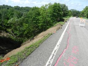
The photo above shows Scott County Highway 60 into Blakeley.The highway had been perched on a narrow ridge between two ravines that lead into the the city. There was work going on in the ravine to the north when the
mid-June rains hit.Slopes had been
cleared of vegetation for the work.The
road was undermined so badly that it was not rebuilt.
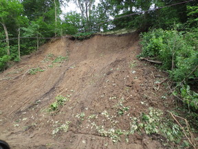
The photo at right shows another slope failure above Highway 13 in Mendota.
A report is being prepared that will identify: key features where the risks for landslides are higher, ways to use existing resources (like geologic atlases) to identify areas of higher risk, and some possible best management practices or restrictions communities could use to reduce potential damage from landslides.
Dr. Carrie E. Jennings is Science Reports Lead for the County Geologic Atlas Program, DNR. Carrie worked for the Minnesota Geological Survey, University of Minnesota for 22 years prior to coming to the DNR. She has taught Glacial Geology at the U of M since 1994. She has mapped the surficial geology of about half of the state at a scale of 1:200,000 or better. She spent 3 years working as a Principal Investigator with the National Center for Earth Surface Dynamics on bluff, ravine and river processes in the Le Sueur River watershed.
Minnesota Association of Floodplain Managers News
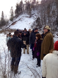
The
annual conference of the Minnesota Association of Floodplain Managers was held
in Duluth, Minnesota on November 19-21, 2014. The theme of the conference was
"It Doesn't Flood
Here! Locations not Historically Prone to Flooding." There were approximately 100
attendees. Major topics discussed included, landslides, hydrologic and
hydraulic modeling, recovery programs, flood control projects, stream
restorations, case studies and mapping. Next year’s conference location was
voted on in a survey from the 2013 attendees and will be held in Moorhead on
November 18-20, 2015. A call for abstracts will be going
out in the Spring.
The conference featured a tour of locations in and near Duluth affected by the 2012 floods, including Mission Creek, at left.
April 2015 - Flood Insurance Surcharges Will Surprise Many
The flood insurance roller coaster continues! There are
several updates in flood insurance premiums that will start to be phased in as
the Biggert-Waters Reform Act of 2012 (BW12) and the Homeowners Flood Insurance
Affordability Act of 2014 (HFIAA) are being implemented. The April 1, 2015 changes
include:
New surcharges on all policies (of either $25 or
$250)
Premium increases of up to 25% for
non-residential and non-primary residential buildings
Premium increases of up to 18% for primary
residential buildings
Starting April 1, 2015, ALL flood insurance policies will
have a surcharge added. Primary
residential structures will have a surcharge of $25. Non-primary residential
and non-residential structures will have a surcharge of $250.
FEMA does not have good documentation of whether residential
structures are primary or non-primary. All residential structures are being
treated as non-primary, until documentation is received that shows the
structure is a primary residence. Insurance companies sent letters to many of
their policy holders over the last few months. Policy holders were notified
that the buildings would be classified as non-primary residential unless
documentation was submitted to show the house is a primary residence. It is
unknown how many of those letters were overlooked or ignored, and how many
policy holders will be surprised with a $250 surcharge due to
not providing that documentation.
What This Means in
Minnesota
It is unknown how many of the residential buildings are
primary versus non-primary, and how many are non-residential. However, FEMA provided breakdowns of the building types for the ~3,500 subsidized Minnesota
policies that were the most impacted by the first phases of implementing BW12
and HFIAA. (These were buildings with subsidized policies constructed before the
first Flood Insurance Rate Maps for their community, i.e., “pre-FIRM” buildings.)
As of late 2012, 11% of the subsidized pre-FIRM policies were non-residential
buildings and an additional 12% were non-primary residential buildings. Based
on those pre-FIRM percentages, we can speculate that about one-quarter of the
policies in the state will be charged the $250 surcharge.
The other major consideration in Minnesota is that nearly
60% of the state’s ~12,000 flood insurance policies are for buildings in the
low risk zones (B, C and X Zones), and a very high percentage of those are the
discounted Preferred Risk Policies (PRPs). These policies are normally
purchased voluntarily and not as a condition of a loan. Typical annual PRP
premiums range from $200-$460, so a surcharge of $250 will represent a
significant increase. Locally and nationally, a large drop in the number of
voluntary policies is expected as policy holders see the premium
increases.
Background on Why the
Premiums are Changing
In July 2012, the
Biggert-Waters Flood Insurance Reform Act of 2012 (BW-12) immediately moved some properties to full actuarial rating.(Full actuarial rating – or full risk rating – means that the premiums are based on how high – or low – the lowest floor
elevation is compared to the Base Flood Elevation, i.e., the 1% annual chance
flood elevation.) The main types of properties affected by this change were homes that existed prior to a Flood Insurance
Rate Map (i.e., “pre-FIRM”), in cases where the home was sold or the owners
purchased a new policy after BW-12 was signed on July 6, 2012. The property owner would then be required to
get an elevation certificate and pay full actuarial rates.For those who purchased policies right after
the bill was signed, these higher rates kicked in when policies started to be
renewed after October 1, 2013.BW-12 also started phasing all the other pre-FIRM building
rates to full actuarial rates, with the increases set at 25% annually for many
classes of structures.
The Homeowners Flood Insurance Affordability Act (HFIAA)
of March 2014 slowed down some of those rate increases by putting a cap of 18%
to any rate increases in any given year for most classes of property. The HFIAA
also removed the requirement for rates to go immediately to full risk when
purchasing a new policy or upon sale.
County Shoreland Management Innovations
The 85 Minnesota counties with
shoreland ordinances are required to complete an annual survey on their
shoreland activities in order to receive annual funding from the Shoreland Management
Grant program (part of the Natural Resources Block Grant administered by BWSR).
Data from the county reports is used to:
Identify activities that are making a difference
in shoreland protection and share those activities with other counties.
Track the amount, type, and location of
development activity to assess development trends and potential threats to
shoreland areas.
Assess how well certain regulatory provisions
are protecting shoreland resources and to identify where DNR follow-up and
assistance are needed.
Many counties
have developed innovative and original approaches to some common
shoreland-related challenges, and the DNR learns of these practices through the
shoreland grant reports. Below are some of these innovative practices
that counties reported in 2013.
Mitigation Practices:
St. Louis and Carlton Counties
St. Louis County
has adopted comprehensive lake management plans for some of its lakes. Any landowner on those lakes who applies for a
conditional use permit or a variance must implement a number of special
mitigation practices. These practices are
chosen by the applicant from lists in the lakes’ plans, with each practice
assigned a point value reflecting its impact. The point total for all mitigation practices must meet a minimum established
for each lake, as well as additional requirements. For example, an applicant on Lake Vermillion
must choose and implement mitigation practices totaling at least six points, with
at least one point covering stormwater/erosion control measures and one point
covering on-site sewage treatment. Currently, four lakes have such plans. See the County’s
web site (Article 46 is the zoning/shoreland ordinance).
Carlton County
requires property owners requesting a variance from the ordinary high water
level (OHWL) of a classified lake or watercourse to complete a Shoreland
Mitigation Plan scoresheet to calculate the existing structure’s degree of
conformance with the ordinance – that is, does it meet required setbacks? The
applicant must complete a revegetation site diagram and commit to engaging in
one or more mitigation activities. These
activities must include shoreland buffer restoration and/or maintenance. Plans may
also include removal of other structures not meeting standard setbacks, removal
of impervious surfaces, wetland restoration, stormwater management, establishing
aquatic vegetation, restoring ice berms, and stabilizing an eroding shoreline. Carlton County site-verified three shoreline
mitigation plans as complete in 2013, with an additional seven scheduled for
completion in 2014. See the County’s Zoning
and Environmental Services Shoreland web page.
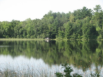
Non-Agricultural Vegetation Management: Beltrami County
A largely natural shoreline in Beltrami County. Photo by Lindy Ekola.
A few years ago, Beltrami County expanded the Shore Impact Zone in their ordinance from the standard one-half the required setback to encompass the entire setback. The county also undertook a cooperative initiative with DNR to create two more restrictive lake classifications in their shoreland ordinance – “Special Protection” and “Sensitive Area” Lakes – in response to a number of development proposals on some of the Natural Environment (NE) lakes. The ordinance states:
“The
Special Protection (SP) management district is established in order to protect
shorelands of waters that are particularly vulnerable to pollution; to maintain
a minimal density of development, and to maintain high standards of quality for
permitted development.
The
Sensitive Area (SA) management district is established to properly manage areas
which may be sensitive to development due to flooding, steep slopes, erosion,
limiting soil conditions, the presence of wetlands, or other physical
constraints.”
Of the 229
Natural Environment lakes in Beltrami County, 126 were reclassified as “Special
Protection” and 81 were reclassified as “Sensitive Area.” These more
restrictive lake classifications increase the minimum lot size and lot width while
limiting certain land uses, such as campgrounds, golf courses and mining. These
restrictions increase the level of protection on lakes with these new
classifications. See the County’s
shoreland ordinance for details.
Other Shoreland Activities: Scott and Koochiching Counties
Scott County
completed two large shoreland restoration and improvement projects on Cedar
Lake and assisted landowners with numerous cost-share projects under its
authority as the Scott Watershed Management Organization. Projects included:
19 water and sediment control basins
7 grassed waterways
3 rock tile inlets
3 native grass
plantings
15 filter strips
4 grade stabilizations
3 streambank stabilizations
1 shoreline restoration
4 rain gardens
1 riparian buffer
Koochiching
County is engaging in several ongoing projects to restore or enhance the Rat
Root River, including river cleanout, bank stabilization, and establishment of
riffle sites for walleye spawning enhancement.
Next month, the
DNR will be sending out the survey of counties’ 2014 shoreland activities. We look forward to learning about other
shoreland-related innovative practices implemented by Minnesota’s counties
through these surveys, and will provide information on such practices in future
issues of Water Talk.
Pervious Pavement in Shoreland: When and Where?
The
use of pervious pavement systems has increased in recent years as an effective
way to reduce the flow of untreated stormwater into surface waters and to recharge
groundwater. While pervious pavement is
preferred over traditional pavement in shoreland areas, it is not exempt from
the 25% impervious surface limit in city and county shoreland ordinances. These
pavement systems can never replace the benefits of native soils and vegetation
in shoreland areas, such as erosion prevention, nutrient uptake, and the
preservation of fish and wildlife habitat and shoreland aesthetics. Minimizing
the amount of hard surfaces in shoreland areas is critical to achieving these
statewide goals for shoreland protection.
Using
a “credit” system to allow the use of pervious pavement to exceed the 25%
impervious surface limit is prohibited in the shoreland district. And in no
case should any hard surface be placed in the shore impact zone (SIZ) or bluff
impact zone (BIZ) unless needed for water access. Any project that proposes to
exceed the impervious surface limit through the use of pervious pavement should
be reviewed as a variance. The following conditions are suggested if a
community finds such a variance acceptable. These conditions include guidance
from the MN Stormwater Manual and DNR field experience:
The slope of the pervious pavement system should
be 2% or less
There should be a 3 foot distance between the
bottom of the pervious system (including its sub base) and bedrock or
seasonally saturated soils.
The system should be designed to infiltrate the
first inch of any storm from the pavement surface.
The system should be designed and installed by qualified
individuals and not by the property owner.
The system should be set back from basements,
septic system leach fields, steep slopes and wells.
The site should be inspected during construction
for compliance
Instructions for maintenance, including a
maintenance schedule, should be provided to the property owner and zoning
administrator or building inspector. Salt and sand should not be applied to
pervious pavement systems.
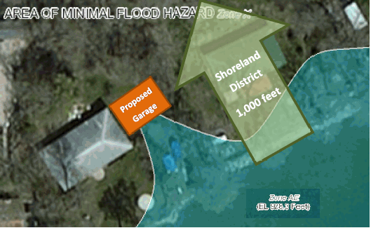
Zoning Challenge
The local zoning official has a resident who wants to
construct a 2 car garage at the very edge of the mapped 1% annual chance
floodplain (100-year floodplain).The
homeowner has had a survey done in the area, and finds that the proposed garage
location is just past the elevation of the base flood elevation (the 1% annual
chance flood elevation).
The local
official’s questions:
Consistent with Minnesota law, the local
ordinance requires the lowest floor to be at the Regulatory Flood Protection
Elevation, or RFPE.Does that mean the
garage floor needs to be elevated to the RFPE if the garage is proposed on land
that is above the 1% annual chance flood elevation, but below the RFPE?
The city has a shoreland management ordinance,
and the proposed building site is in the shoreland district.Does that make a difference?
(See answer at end of newsletter.)
Red River Valley: Water, Water, Everywhere…and Lots of Places to Store It
The Red River Valley is the site of multiple flood control initiatives because of its unique geographic characteristics. As described in AgWeek, the Red River Valley of the North is a, “25-million-acre watershed spreads across a mosaic of farmlands, grasslands, forests and wetlands. The valley is one of the most productive breadbaskets of the world and home to critical habitat for wildlife and migratory birds, as well as millions of people living in Minnesota, North Dakota, and South Dakota.”[1]
What is unique to the Red River is that its gradient is particularly shallow. While the river is approximately 550 miles long, beginning at the confluence of the Otter Tail and Bois de Sioux Rivers in the City of Breckenridge, flowing northward into Canada and finally ending at Lake Winnipeg, the river drops but 230 feet—less than one foot per mile—over its entire course. As a result, the river lacks the energy to have created a true valley. Rather, at times of high water it simply spreads over the ancient lake bed through which it flows, flooding farms, towns, and cities, often miles from its channel. Since 1950, the Red River has experienced four major floods impacting large portions of the watershed, including the devastating floods of 1997, 2009, and 2011. In addition to major flooding, the river’s lack of energy and northward course also makes it unusually susceptible to localized ice jams.
New Funding Available through Federal Farm Bill for Flood Prevention and Conservation
To help address these longstanding problems, on July 2, 2014, Agriculture Secretary Tom Vilsack announced that through the 2014 Congressional Farm Bill, an additional $50 million in federal funds would become available to help support flood prevention and conservation in the Red River Valley in Minnesota and North Dakota during the next five years. These funds are in addition to the typical funding available to all states.
The additional funds will be available through the Natural Resources Conservation Service’s Environmental Quality Incentives, Conservation Stewardship, and Agricultural Conservation Easements programs. Unlike many earlier flood control efforts nationwide, much of the funding will be used to retain water in-place and to benefit the natural functions of wetlands and other critical habitat, rather than simply hardening channels and diverting water from population centers. Flood mitigation programs that may be eligible for funding could include:
Compensation to farmers for water retention efforts that reduce flooding on the Red River;
Efforts to improve water and air quality, conserve ground and surface water, reduce soil erosion and sedimentation, improve or create wildlife habitat; and other structural and non-structural solutions.
Where to Store the Water?
In Minnesota,
several flood control projects in the Red River Valley are already in
development under the auspices of the Red River
Retention Authority. The authority was
formed in 2010 to pursue water retention projects in the Valley following the
record 2009 flood. Its overall goal is to
reduce the volume of water reaching the Canadian border by twenty percent
during flooding events. As reported in Bakken Today, a “twenty percent
reduction in a 1997-level flood would reduce the crest at Fargo-Moorhead by two
feet”.[2]
However, this
level of reduction would require impounding 1 million acre-feet below the
Canadian border, distributed among many projects throughout the basin. A study for the Red
River Basin Commission, an intergovernmental advisory group, finds that retention
waters could be stored at 96 impoundment sites, covering nearly 560,000 acres
across the watershed. However, those
sites are generally found on private land, which in the Red River Valley means
it is likely to be working farmland. Finding willing property owners and equitable compensation will take
money, good will, and as Gary Thompson, a representative of North Dakota water
resource districts remarked, “a lot of time and effort,” to get everyone on
board.
In many ways,
this effort is more of a natural lands and wildlife conservation project than a
flood control effort. But as we have
learned over the past century of flooding projects, it is often to society’s
benefit to work with nature to store and retard floodwaters closer to their
source by using the natural functions of wetlands and other areas for water
storage rather than only fortifying the built environment downstream.
Secretary Vilsack noted in his remarks that the program “comes with a great deal of flexibility, and can
allow farming practices to continue on land involved in conservation projects
when water conditions allow.” It will be a long process, and one
that will take many years to complete, but as Vilsack concluded, “projects can
be as small as one section of land,” and “we want to get started now.”
Additional technical and financial
assistance information about these programs can be found by visiting the NRCS’s
website at www.nrcs.usda.gov/GetStarted or by contacting a local USDA service
center. A local office may be found by
visiting the USDA’s Minnesota Service Center Locator at offices.sc.egov.usda.gov/locator/app?agency=nrcs&state=mn.
NOTE: Dates shown as "anticipated" have a high probability of being pushed back as
issues arise
New Maps Going Effective:
Mahnomen County – Effective on April 2, 2015
Wilkin County – Effective on May
18, 2015
Letters of Final Determination (Letters sent 6 months before effective dates):
Norman County – February 2015 (anticipated)
Olmsted County – March 2015 (anticipated)
Hennepin County – March 2015 (anticipated)
Anoka County – April
2015 (anticipated)
Roseau County – May 2015 (anticipated)
90-Day Appeal Periods:
Kandiyohi County – 10/17/2014 to 1/14/2015
Carver County
– January to April 2015 (anticipated)
Polk County – January to April 2015 (anticipated)
Wright
County – February to May 2015 (anticipated)
Scott County
– February to May 2015 (anticipated)
Crow Wing
County – February to May 2015 (anticipated)
Marshall
County – February to May 2015 (anticipated)
Open Houses: None scheduled
New Preliminary Maps:
Wright County (revised) – January 2015 (anticipated)
Houston County – January 2015 (anticipated)
Chippewa County – January 2015 (anticipated)
Yellow Medicine County (revised) – January 2015 (anticipated)
Winona County – March 2015 (anticipated)
Zoning Challenge Answers
Answer to Question 1
A
local floodplain management ordinance that
meets the minimum state floodplain requirements (and where the community does not have a shoreland ordinance) is only enforced in areas that are below the
base flood elevation (the 1% annual chance elevation). In this
example, a survey shows that the building footprint is above the 1%
annual chance flood elevation, so the floodplain management ordinance is
not enforced.
Note: IF the building footprint is in
the 1% annual chance floodplain (i.e., on land below the flood elevation), the minimum floor elevation must meet the
Regulatory Flood Protection Elevation (RFPE), which is the flood elevation plus
at least 1 foot of freeboard, plus any stage increase caused by establishing
floodway versus flood fringe areas.
If there is a conflict between the floodplain map and a survey,
the actual ground elevations determine whether floodplain zoning
requirements apply.
For the purpose of determining whether it is mandatory to purchase of flood insurance, however, the floodplain shown on the FEMA map is still
the controlling element, unless the landowner obtains a Letter of Map
Amendment (LOMA) from FEMA.
Answer to Question 2
YES, it makes a difference! If the city has a shoreland management
ordinance, that ordinance specifies minimum floor elevations. If the 100-year flood elevation has been determined,
the low floor needs to meet the RFPE. If the flood elevation has not been determined, the low floor must be 3
feet above the Ordinary High Water (OHW) elevation or the Highest Known Water
Level, whichever is higher. In this
example, the flood elevation is known, so the garage would need to be elevated to
the RFPE.
Note: Since
most local floodplain ordinances allow garages up to 576 square feet to be wet
floodproofed, DNR has agreed that it is consistent with the shoreland
management requirements for a community to allow the area below the RFPE to be
floodproofed rather than elevated on fill, and more floodproofing options can
be considered for other types of structures.