Welcome to the third issue of 2014. The Water Talk* newsletter is published electronically 2-4 times a year, focusing on topics and resources related to floodplain management, shoreland management, and other DNR land use programs: Wild & Scenic Rivers, and the Mississippi River Corridor Critical Area.
Our main target audience is local officials involved with floodplain and shoreland management or mapping, as well as those at the watershed district, regional, state & federal level. Other target audiences include: surveyors, engineers, lenders, insurance agents, realtors, and others involved with properties or projects in floodplain and shoreland. If you did not receive this link directly, you can subscribe at: http://www.dnr.state.mn.us/waters/watermgmt_section/floodplain/index.html
Help us to keep our local official contact list current.If you are the city or county contact for zoning / permits, or the engineering contact, or the emergency manager, and you did not receive the link to this newsletter directly, please forward your contact information and role to ceil.strauss@state.mn.us
Please let us know what you think of the content and format of this newsletter, which will continue to evolve based on your feedback. Contact Ceil Strauss (see above) or suzanne.rhees@state.mn.us
Flood Recovery Update
Recovery from the
spring 2014 floods continues across Minnesota, with a few new developments
since our July newsletter:
Hennepin and Ramsey counties were added to the presidential
disaster declaration originally received July 21.This means 37 counties and
three tribal governments will receive federal and state assistance to recover
from damages to public infrastructure caused by severe storms, mudslides and
flooding. See FEMA’s map
of the disaster areas here.
The Minnesota Rural Finance Authority (RFA) is expanding the
eligibility of its zero percent interest rate Disaster Loan program. The loans
are now available in 32 counties to help farmers cover the costs to repair and
replace items not covered by insurance from flooding that occurred in early
July.
The Minnesota Housing Finance Administration provides
loans up to $70,000 if your home or rental property was damaged in the June
floods.
Community Fix Up flood loans can provide up to $50,000 in repair funding if you
have qualifying credit.
For those who do not
qualify for a Community Fix Up loan, or for those who have flood repair
needs beyond what is covered by the Community Fix Up loan, the Quick
Start Disaster Recovery Program can provide additional
assistance up to $20,000. Learn
more about both programs here.
MHFA will work with organizations that are able to make both types
of loans to conduct outreach and process the loans so that flood victims
will not have to go to multiple lenders.
The interest rate on a home improvement loan will be subsidized to
bring it down to 3%.
The application deadline for both programs is October 24, 2014.
The DNR’s Flood
Damage Reduction program is funded by the Legislature. Since there was no post-flood
special legislative session, program funding will be contingent on decisions
made during the 2015 legislative session.
Shoreland Ag Buffers: Progress on Compliance; Questions Remain
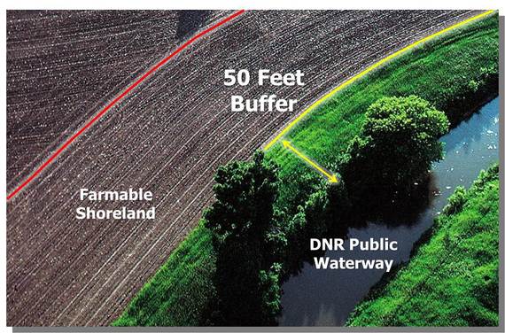
The Minnesota "Shoreland Rule" is a broad DNR rule (Chapter 6120) adopted in 1989 that includes a provision for a 50’ buffer in agricultural areas along all public watercourses on the Public Waters Inventory (PWI).Stream reaches subject to the buffer requirement are typically listed in the county or city shoreland ordinance, and enforcement of the buffer requirement is by local governments.
The rule also states that "general farming, grazing, nurseries, horticulture, truck farming, sod farming and wild crop harvesting are permitted uses if steep slopes and shore and bluff impact zones are maintained in permanent vegetation or operated under an approved conservation plan consistent with field office technical guides of the local soil and water conservation districts or the U.S. Soil Conservation Service" (now NRCS). In other words, counties can allow farming within the 50-foot buffer area when an NRCS or SWCD approved conservation plan is in place (although few, if any, of these plans exist for this purpose).
The “ag buffer” requirement can be difficult for local governments to enforce. Unlike most land development activities, agricultural activities generally do not require zoning or other land use permits, and without high-quality aerial photography, it can be difficult to determine compliance on the ground.
The DNR is working to clarify the various types of watercourses that should be buffered, especially those water bodies classified as “altered natural watercourse/public ditch.” The statutes and rules that cover public ditches (103E) and public waters (103F and 103G) are not entirely aligned with each other, and the PWI maps are not always up-to-date.The DNR is currently researching the ag buffers issue in order to assist counties and other local governments with consistent guidance, imaging, analysis, and improved compliance.
Counties Report Progress
Minnesota counties are making slow but steady progress
toward statewide compliance with the ag buffer requirement. In
a survey of the 85 counties receiving block grants for shoreland activity
administration, 33 reported enforcing the buffer requirement in 2013, while 28
stated they did so in 2012. Two additional
counties rely on voluntary participation in USDA-NRCS or local SWCD and
Watershed District programs to achieve the same goal, and two more reported
that they are working towards compliance.
Common tools reported for achieving compliance are:
Requiring compliance for permit and variance approvals
Identification of
noncompliance during site plan review processes
Responding to complaints
Six counties reported engaging in enforcement actions related to violations
Common activities reported for increasing compliance and effectiveness of ag
buffers include:
Landowner outreach; providing technical assistance and
education
Assisting landowners with expenses through cost-sharing, grants, or
other financial tools
Partnering with SWCDs or other organizations to promote
buffers
Engaging or partnering on restoration and similar
projects
Obstacles to increased compliance reported include:
Unavailability of
detailed air photos and analytical tools
Shortages of funding for staff and
activities
Administrative and political reluctance
Lack of knowledge as to the extent of compliance
Technological advances (e.g. LiDAR,GIS, etc.) and greater availability of funding options such as the Clean Water Fund should help counties achieve greater compliance over time. While additional research is needed, compliance with the existing ag buffer requirements can play a large part in cleaning Minnesota's waters.
The
Biggert-Waters Flood Insurance Reform Act of 2012 (BW-12) immediately moved some properties to full actuarial rating.(Full actuarial rating – or full risk rating
- means that the premiums are based on how high - or low - the lowest floor
elevation is compared to the Base Flood Elevation, i.e., the 1% annual chance
flood elevation.) The main types of properties affected by this change were homes that existed prior to a Flood Insurance
Rate Map (i.e., “pre-FIRM”), in cases where the home was sold or the owners
purchased a new policy after BW-12 was signed on July 6, 2012.The property owner would then be required to
get an elevation certificate and pay full actuarial rates.For those who purchased policies right after
the bill was signed, these higher rates kicked in when policies started to be
renewed after October 1, 2013.
BW-12 also started phasing all the other pre-FIRM building
rates to full actuarial rates, with the increases set at 25% annually for many
classes of structures. The Homeowners Flood Insurance Affordability Act (HFIAA)
of March 2014 slowed down some of those rate increases by putting a cap of 18%
to any rate increases in any given year for most classes of property. The HFIAA
also removed the requirement for rates to go immediately to full risk when
purchasing a new policy or upon sale.
This means that property owners who saw increases in flood
insurance premiums of greater than 18% last year could be eligible for a
one-time refund of a part of the premiums they paid last year. You may have heard about these refunds in
mainstream media. Floodplain Managers
should be very careful about discussing refunds with their citizens. Only a small percentage of people will
actually get a refund. You do not want to give someone the impression they will
get a refund in case they don’t qualify.
Pre-FIRM secondary homes and buildings meeting the
definition of repetitively flooded structures will not be receiving
refunds. In order to help you to better
understand which structures may qualify for a refund and which ones will not,
FEMA has produced a useful information sheet.
Link
to FEMA’s “Flood Insurance Premium Refunds: Who Gets Them? Who Does Not?”
How to Save Money on Flood Insurance
Many property owners who bought new policies (including as a result of a sale) after July 6, 2012 saw flood insurance rates shoot up due to provisions of the Biggert-Water Reform Act of 2012 (BW-12). In many cases, those property owners will now get refunds, starting October 2014, due to changes in the law as a result of the Homeowners Flood Insurance Affordability Act of 2014 (HFIAA). While currently subsidized rates will not go up quite as
fast as originally required in BW-12, the rates are still moving towards full actuarial
or full risk rates. It will be a longer,
slower climb, but most structures will eventually get to a full risk rating.
Owners of property in the floodplain should look at ways to
save money on the cost of flood insurance now and not later. The
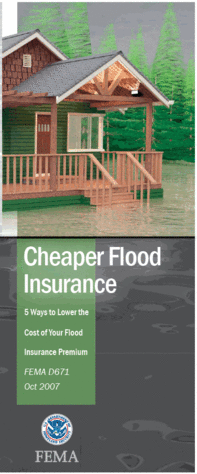
Federal Emergency Management Agency (FEMA) has published a 2-page information
sheet with illustrations of 5 methods of retrofitting a property to save money.
Elevating machinery and equipment above the base
flood elevation;
Installing flood openings in an enclosed area
below the lowest floor;
Filling in basements is one of the most affordable options,
but will not be a popular option in many parts of Minnesota. However, depending
on the building style and layout of the lot, some of these other methods could
be considered. For example, a building on a crawl space may be able to add flood
openings that would save money through lowered flood insurance premiums; the
payback could be a matter of a few years in some situations. New development proposed
in the floodplain could be relocated to a portion of a lot outside of the
floodplain or elevated to a level higher than the minimum required by the
community.
Another potential way to save on flood insurance premiums
for a house built prior to a Flood Insurance Rate Map (“pre-FIRM”) is to have
an elevation certificate prepared. The
flood insurance rates for pre-FIRM houses are going to continue to rise at a
relatively high rate each year. Most of
these properties currently get a subsidized rate, but if the lowest floor is
not too far below the flood elevation (especially if they are within 1-2 feet) the
full risk rate could actually be lower than the subsidized pre-FIRM rate. The
insurance agent can compare rates and give the property owner either the
pre-FIRM rating or the full risk rating based on the elevation certificate,
depending on which one is cheaper. Even
if the elevation certificate doesn't yield a better rate right away, the
property owner can see what the full risk rate is, and be ready to switch to
the full risk rate as soon as it becomes cheaper.
In future Water Talk Newsletters, examples of different
types of mitigation will be highlighted.
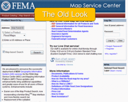
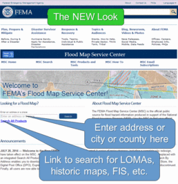
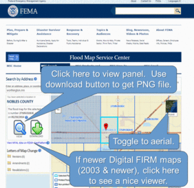
FEMA’s Map Service Center’s (MSC’s) Dramatic New Look
FEMA’s Map Service
Center (MSC) is a great resource for: finding the current FEMA Flood Insurance
Rate Map (FIRM), making a “FIRMette” of a portion of the FEMA map for a site of
interest, finding a copy of a Letter of Map Amendment (LOMA), finding
historical FEMA maps, etc.
As of July 28, 2014, the MSC looks completely
different than it has for the last decade!The old format can be seen in the top figure to the right.The new format is in the bottom figure.
Some Hints for the New Site:
The new site does not work on some computers
with Internet Explorer. If the site
doesn’t work, try another browser.
The address searcher is greatly improved from
the old site. You can enter addresses, a
city or a county name.
To search for specific Letters of Map Amendments
- or LOMAs - and other Letters of Map Change (LOMCs), click on the “Search All
Products,” enter the case number in the “Product ID” spot and “Search.”
At the Search All
Products page you can use the drop down boxes to get to a city or county, or
enter the name in the “Jurisdiction Name” box.
Hit “Search” to see option to view and/or download current and historic
panels, LOMCs, Flood Insurance Studies, etc.
Hints for
Panel Locater Page:
Note the toggle to view with aerial or road map
background.
Click
“View” button to see pdf of panel or use download button to get PNG file of
panel.
If you
“View” a panel, you’ll have the option to make a “FIRMette” (as on the old
site).
Click in adjoining areas to see sites on near-by
panels.
If in county with maps updated in 2003 or more
recently, there will be a link to FEMA’s National Flood Hazard Layer (NFHL)
viewer. That has many background options
(aerial, road map, etc.), with overlays of: 1% & 0.2% flood layers, floodway,
cross-sections (with flood elevations) and LOMA locations (purple dots).
A Minnesota city received a variance request to replace a
nonconforming, dilapidated, detached garage with a new attached garage.
The entire property is in the 100-year floodplain. The
regulatory flood protection elevation (RFPE) is 982.8 feet (NGVD29). The floor of the proposed attached garage
would be at 982.8 feet. The finish floor
of the existing house is at 982.0. The house has a crawl space below the
finish floor.
The Zoning Administrator states, “As I understand it, unless
the applicant requests a conditional use permit and floodproofs the house, the
floor of the crawl space must also be at the regulatory flood elevation of
982.8. This would put the finish floor of the house somewhere around
985.3 (allowing for the crawlspace). The contractor, surveyor, and others
have argued that a crawlspace is uninhabitable and therefore does not have to be
elevated to 982.8.”
Is a variance needed to allow the crawl space floor to remain at its
current elevation? Is a variance an
acceptable solution?
DNR's response is at the end of this newsletter.
Risk MAP Fall 2014 Update
FEMA’s national
Risk Mapping, Assessment, and Planning (Risk MAP) program is intended to result
in local activities that reduce risk. In
Minnesota, FEMA and the Minnesota Department of Natural Resources and
Department of Public Safety – Homeland Security and Emergency Management (HSEM)
have been working with STARR, FEMA’s consultant, to discuss local mitigation
actions with Minnesota communities. Communities
are asked to identify actions that could reduce the risk of flooding or flood
damages. These “mitigation actions” are
used to inform local planning efforts and may be considered for future funding.
In addition, some communities are receiving technical assistance or other
support to reduce risk.
While final
decisions have not yet been made, several communities are considering actions
such as adopting higher regulatory standards for floodplain management. FEMA or
the DNR can provide technical support to these communities. The City of
Worthington is working with HSEM to identify partial funding sources for a
planned flood mitigation project that includes water retention and culvert
redesigns to reduce neighborhood flooding.
In the fall and
winter, engagement will begin with the cities of Minneapolis, Albert Lea,
Austin, Chatfield, Peterson, Preston, Rushford, Spring Valley, Bloomington,
Delano, Eden Prairie, Minnetonka, Rockford, and Watertown; Fillmore, Mower,
Carver, and Wright counties; and 32 communities in the St. Louis River watershed.
The selected communities can anticipate hearing from STARR about meeting dates,
and may also be contacted by telephone about mitigation interests, needs, and
community goals in risk reduction. Communities are invited to identify
organizations and stakeholders to be involved in the effort, which is geared
toward helping the community plan a risk-reducing activity that may include
technical support from FEMA.
If you have any
questions about the program, please contact any of the following project
partners:
Have you gone to DNR’s “Data Deli” site in the past? The floodplain data (plus much more!) that
had been available at the Data Deli in the past is now available at the GeoCommons site The GeoCommons site – “A collaborative
place for users and publishers of geospatial resources in Minnesota” – is a
great place to visit for many categories of spatial data in Minnesota.
Floodplain Data Available on GeoCommons:
Digital Flood Insurance Rate Maps (DFIRMs) for
counties that have FEMA maps updated from 2003 and later (flood zones, floodway,
BFEs, cross-sections, panels)
“Unmodernized” floodplain layers. Also known as “Q3” layers. Counties that were declared in the 1993
Presidential disaster had existing FEMA floodplain boundaries digitized. For the counties that do not have DFIRMs (see
#1), these are the best available layers showing flood zones, floodway, and
FEMA panels. These are good for planning
and reviews, but do NOT replace the official FEMA maps.
Limited Detail Base Flood Elevation (BFE)
data. In many of the counties that have
or are in the process of getting new DFIRMs, modeling was done to determine 1%
annual chance flood elevations in approximate A Zones. These represent the “best available data” for
those watercourses, but the modeling was not done with the rigor required to be
shown as “detailed” studies on the FEMA maps.
Training Opportunities
GTS Variance Seminar for Local Government Officials and Staff
A Practical Guide to Variances in Shorelands & Floodplains will be offered through GTS Educational Events on Wednesday, October 29, from 1:00 - 5:00 pm, at Arrowwod Resort & Conference Center. Learn from the experts how to make decisions in light of Minnesota's changed variance laws. Includes why the regulations are important, special considerations when dealing with these sensitive areas, and exercises based on actual situations.
See www.mngts.org/LandUse for further information, or contact Carol Schoeneck at 651-222-7409, ext. 205.
MnAFPM Conference: It Doesn't Flood Here!"
The
2014 Minnesota Association of Floodplain Managers (MnAFPM) conference will be held November 19-20 at the Holiday Inn, Duluth. Trainings and
breakout sessions will occur on November 19th and 20th with an opportunity to
take the CFM test on Friday the 21st. There will be a field tour of local flood
projects on Wednesday afternoon.
Theme: "It Doesn't
Flood Here! Locations not Historically Prone to Flooding."
Call
for Sponsors & Exhibitor: For
information on becoming a sponsor or exhibitor, click here.
Registration
is now open!
Click here to register for the
2014 MnAFPM conference!
DNR's Floodplain Management Trainingis a free one-day course designed for local officials, surveyors and engineers, realtors, insurance agents, and other interested citizens. The 2014 sessions include both general and specialized topics:
Floodplain zoning basics
Floodplain map basics
Letters of map change (LOMA, LOMR-F and LOMR)
Flood insurance basics - including the latest insurance reform
Ordinance administration
Estimating base flood elevations in A zones
Higher regulatory standards
Training sessions have been held this fall in Milaca, Thief River Falls, Minnetonka, and Winona. Additional trainings will be scheduled in 2015. Watch for a survey on desired training topics. For further information, e-mail ceil.strauss@state.mn.us or call Ceil at 651-259-5713.
There are many other training opportunities available through FEMA, the Minnesota Department of Homeland Security and Emergency Management, and other sources. See the
DNR website for a complete list.
FEMA Map Updates
New Maps Going Effective:
Freeborn County – Effective on November 19, 2014
Letters of Final Determination (Letters sent 6 months before effective dates):
Mahnomen County – October 2, 2014
Wilkin County – October 2014 (anticipated)
Anoka County – December 2014 (anticipated)
Norman County – December 2014 (anticipated)
Olmsted County – December 2014 (anticipated)
Hennepin County – January 2015 (anticipated)
Roseau County – January 2015 (anticipated)
90-Day Appeal Periods:
Carver County – October 2014 to January 2015 (anticipated)
Nicollet County – October 2014 to January 2015 (anticipated)
Scott County – October 2014 to January 2015 (anticipated)
Kandiyohi County – November 2014 to February 2015 (anticipated)
Crow Wing County – December 2014 to March 2015 (anticipated)
Wright County – January 2015 to April 2015 (anticipated)
Open House:
Marshall County – December 2014 (anticipated)
New Preliminary Maps:
Wright County (revised) – November 2014 (anticipated)
Houston County – November 2014 (anticipated)
Chippewa County – December 2014 (anticipated)
Winona County – December 2014 (anticipated)
Yellow Medicine County – December 2014 (anticipated)
Mississippi River Corridor Critical Area: Informal Public Comment Period Wraps Up
The MRCCA is a land corridor along the Mississippi River within the seven-county metro area. There are 30 local governments within the 72 mile long, 54,000 acre corridor. Land development in the corridor is guided by existing state regulations, which are implemented through local government plans and zoning ordinances. The proposed rules, if adopted, would replace the existing regulations. A Request for Comments on the proposed rules was published in the State Register on June 2, 2014.
Rulemaking in Minnesota includes an informal information-gathering phase, which begins with a Request for Comments, and a formal comment period, which begins with a Notice of Intent. Typically, the Notice of Intent marks the point when draft rules are released for public review. The MRCCA process is somewhat unique in that the draft rules were made available for review during the informal comment period.
The DNR held three well-attended public meetings in July, met individually with various interest groups, and accepted comments through September 30, 2014. About 560 separate comments were received from local governments, residents and businesses, and a variety of agencies and organizations. The project team is now in the process of analyzing the issues raised and planning a final round of revisions to the draft rules, before releasing a formal Notice of Intent.
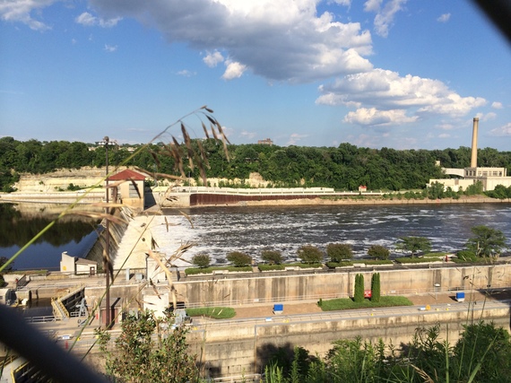
The hydroelectric plant below the Ford dam in St. Paul is one of the historic sites in the MRCCA
Zoning Challenge Answer
Here is the DNR's response to the question above:
The crawl space DOES need to meet the Regulatory Flood
Protection Elevation (RFPE). The
proposed crawl space with a floor at 980.0 (NGVD29) is not an acceptable
variance. The City’s ordinance, consistent with the federal regulations,
specifies several limitations on floodplain variances that can be allowed,
including the requirement that no variance shall permit a lower degree of
flood protection than the regulatory flood protection elevation.
The surveyor, contractor and others have argued the crawl
space does not count since it is not inhabitable. They do not have a
correct understanding of the regulations. The City’s ordinance requires
that the lowest floor, including basement, must be above the RFPE.
Federal regulations and the ordinance define a basement as any space that is
subgrade on all sides. See also DNR’s fact
sheet on basement definitions.
DNR and FEMA would strongly object to a variance to the
lowest floor elevation, as is currently proposed.
Finally, if the applicant wants a crawl space, there is an
option to have an above-grade crawl space that is constructed with flood
resistant materials and has automatic opening vents. FEMA’s Technical
Bulletin 1 gets into more details on the standards. The City’s
ordinance would allow the wet floodproofed above-grade crawl space and/or
garage as a conditional use.