|
Winter 2025
Restoring Swift Coulee: A Prairie Stream Reimagined
Throughout this past summer, multiple excavators could be seen working in and along the streambed of the Swift Coulee located just north of Warren, MN. These efforts marked the beginning of Phase 1 of the Swift Coulee Channel Restoration Project, a major initiative led by the Middle Snake Tamarac Rivers Watershed District (MSTRWD). The project’s goal is to reduce flood damage to farmland and public roads caused by heavy rainfall events, while also improving water quality and restoring wildlife habitat in this unique prairie stream corridor.
Over time, changes to the Swift Coulee—such as sediment accumulation and channel modifications—have altered its natural drainage patterns and reduced aquatic habitat along the stream corridor. Breakout flows periodically damaged agricultural lands and public infrastructure. In response, MSTRWD and its partners developed a plan to restore approximately 16.8 miles of altered stream and 530 acres of riparian wetland and prairie habitat. Phase 1 alone will restore 7 miles of stream and 245 acres of habitat across 16 parcels owned by 11 landowners. It will result in over 240 acres of new and improved riparian habitat, helping restore the ecological integrity of the Lake Agassiz Aspen Parklands region.
Restoration work includes a two-stage Rosgen E-channel design with a highly meandering path inside the valley floodplain. Pools are being excavated along bends to slow water flow and expand habitat. Strategically placed setback levees are being proposed to reduce the risk of breakout flows that would reenter the Swift Coulee further downstream or leave the sub-watershed completely.
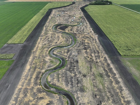 Photo Credit: Houston Engineering Incorporated. Drone photo of the Swift Coulee after channel restoration excavation returned sinuosity and constructed a floodplain area within setback levees.
Detailed modeling efforts were performed to analyze the setback levee in areas of potential wetland impacts. In locations where the flow will not breakout but only swell on the landscape and reenter the proposed channel in a similar location, no setback levees are being proposed. The project corridor expanded buffer areas to aid in filtering nutrients and sediment. These buffers also meet Minnesota’s buffer law and support the Reinvest in Minnesota (RIM) program.
Additional features include 31 side inlet culverts with flap gates to prevent backflows, and four grade control structures using rock riffles to stabilize the channel and allow fish passage. These improvements will reduce erosion, improve stream stability, and enhance aquatic habitat.
Funding for the $5 million-plus Phase 1 effort comes from a mix of sources, including Watershed Based Implementation funds, a Minnesota Board of Water and Soil Resources (BWSR) grant, LSOHC, MSTRWD, and FDRWG that covered the engineering, permitting, land acquisition, and construction. The Swift Coulee Project Work Team was first formed in 2016, and the project was formally established in June 2023 under Minnesota Statute 103D.605. With strong collaboration and a clear vision, the Swift Coulee Channel Restoration is bringing lasting benefits to the land, water, and wildlife of northwest Minnesota.
Bringing Back the Bend: Buffalo River Restoration
In Wilkin County, new life is coming back to the South Branch of the Buffalo River. The Buffalo-Red River Watershed District (BRRWD), in collaboration with landowners and numerous partners, undertook a major stream restoration project. Stretching from several miles east of Highway 9 to the Wilkin/Clay County line, this project focuses on restoring 18 miles of the South Branch of the Buffalo River.
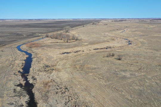 Photo Credit: Wilkin County Soil and Water Conservation District. Drone photo showing how the stream channel had been straightened and disconnected from oxbows by previous ditching.
Historically, the headwaters of the South Branch of the Buffalo River was channelized to become Wilkin County Ditch No. 44. This shortened the channel from 4.6 miles to 2.7 miles, which reduced its capacity to handle large flood events and disrupted natural habitat. The channelization also resulted in decades of challenges with flood damage, poor drainage, and diminished water quality. Phase 1 of the project restores 4.6 miles of the river to its original flow path, improving conveyance and reducing breakout flows that affect agricultural fields. A two-stage channel design helps stabilize the stream and support aquatic life, while riprap sections manage sediment and prevent erosion. Overall, the restoration aims to improve how water moves through the landscape while enhancing habitat and protecting farmland.
The restoration also includes side inlet structures and sediment best management practices (BMPs) to reduce turbidity and improve water quality. Expanded buffer zones and natural resource enhancements (NREs) provide habitat for wildlife and help meet conservation goals. With no adverse downstream effects expected, the project is a win-win for both landowners and the environment.
Eran Sandquist, Director of Conservation Delivery with Pheasants Forever and Quail Forever, commented on how collaborative flood damage reduction projects can incorporate features for wildlife: “There can be a lot of overlap between flood reduction interests and wildlife habitat projects that benefit all citizens of Minnesota. We are proud of the partnership that met at that intersection and accomplished both!”
Construction of Phase 1 was completed in early 2025, and BRRWD will begin construction of Phase 2 this fall. Phase 2 of the project will be completed over several phases and will stretch from Highway 9 to the Clay/Wilkin County line.
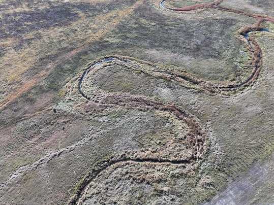 Photo credit: Houston Engineering Incorporated. Post-channel restoration drone photo showing the Rosgen E-channel design created by the project.
Funding for the South Branch of the Buffalo River Restoration comes from multiple sources, including $4.9 million from the Natural Resources Conservation Service (NRCS) through their National Water Quality Initiative Program, $1.3 million from the Minnesota Department of Natural Resources (DNR) through their Stream Habitat Program, $1.195 million from the Outdoor Heritage Fund (OHF) through the Lessard-Sams Outdoor Heritage Council, $300,000 from the Minnesota Board of Water and Soil Resources (BWSR), and a district-wide levy. Additional support may come from a Clean Water Fund (CWF) grant, and long-term maintenance will be covered by the Water Management District.
The project also includes a permanent easement corridor, ranging from 140 to 250 feet wide, for construction and future maintenance, ensuring long-term access and stewardship. Land previously held by Pheasants Forever has been transferred to the Minnesota Department of Natural Resources for designation as a Wildlife Management Area (WMA), further expanding conservation benefits. As work progresses, the project stands as a strong example of how thoughtful design and collaboration can restore natural systems and protect valuable resources across the Red River Basin.
Announcements
-
The Work Group’s next meeting will be in-person on Wednesday, December 10 at the Prairie Grains Conference in Grand Forks, ND. Contact the Red River Basin Coordinator or check the conference website for meeting details. Conference registration is not required to attend this meeting.
-
Annual Joint Conference will be held in Moorhead on March 17 and 18. Hosted by the FDRWG and Red River Watershed Management Board (RRWMB), participants gather to share information and experiences related to flooding, farming, and natural resources in the Red River Basin. For more information and registration, check the RRWMB website in January.
-
The FDRWG’s Five-Year Monitoring Program concluded its second field season in September. Monitoring is being performed by Moore Engineering and the DNR’s Division of Ecological and Water Resources. The International Water Institute is coordinating field activities on behalf of the FDRWG. This work is funded with a grant from the Environment and Natural Resources Trust Fund (ENTRF).
-
The Minnesota Board of Water and Soil Resources (BWSR) is now accepting applications for $4.5 million in Water Quality and Storage Grants to support projects that improve landscape resilience to severe weather. Applications are due by December 23, 2025 and more information is available on the BWSR website.
|