|
Spring 2025
Water Beneath our Feet
At the Annual Joint Conference in Moorhead in March, Ellen Considine, Geohydrologist with the Minnesota Department of Natural Resources, provided an overview of groundwater resources in Minnesota’s portion of the Red River Basin (RRB). Rural and some city residents of the RRB are familiar with groundwater as the source for their well water supplies. However, the basin overall is limited in groundwater compared to other parts of Minnesota due to the extensive clay deposits left behind by Glacial Lake Agassiz that are relatively impermeable, which restricts the water available to wells.
Water-bearing sand and gravel deposits can be found within the lakebed, but these are few and far between. Narrow ribbons of sand and gravel that yield groundwater can also be found along the “beach ridges” that line the eastern edge of the ancient lake.
The extensive clay soils also limit how fast groundwater can replenish buried aquifers. In an area where an average of 22 inches of precipitation occurs annually, only 2 to 4 inches may sink into the ground and reach buried groundwater reserves. The rest of the water runs off the landscape, evaporates or is taken up by crops and other vegetation.
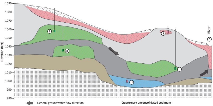 This is a conceptual geologic cross section. It shows how parts of the Red River basin's geology (in gray) don't have aquifers. Where there are aquifers (in pink, blue and green), they are limited in size. Source: Geologic Atlas of Clay County, Minnesota, Part B, County Atlas Series C-29.
The DNR operates a network of observation wells to monitor water levels in aquifers across the state. In the Red River Basin, 28% of wells had downward-trending groundwater levels between 2003 and 2022. This contrasts with the rest of Minnesota, where only 7% of wells had downward trends.
Based on this information, Considine suggested that large-scale, sustained production of groundwater is unlikely to be viable in the Red River Basin. For example, uses approaching or exceeding 100 million gallons per year may not be achievable in many parts of the Basin. Excessive pumping can cause nearby users to lose their supplies when water levels in the aquifers drop. Where water is needed for large users, the best strategy may be to use groundwater as a backup source rather than a primary supply. This approach can avoid depleting the limited aquifers available, so they will be able to provide at least some water locally during drought periods and continue supplying household wells that have no other options.
For more information on ground water in the Red River Basin, consult the Minnesota Geologic Survey’s County Hydrogeologic Atlas Series (Part B). Atlases are available for Clay and Becker counties and are under development for Otter Tail County. The Survey also mapped aquifers at a bigger scale in 2005. More detailed information can be found in the report titled “Geological mapping and 3D model of deposits that host ground-water systems in the Fargo-Moorhead region, Minnesota and North Dakota.”
Putting Projects on the Path to Success
Go to a meeting of any watershed district that develops flood projects in the Red River Basin and you’re likely to hear about at least one “project team” and perhaps, several. For 27 years, watershed districts, state and federal agencies, local landowners and conservation organizations have used project teams as the basic engine for planning projects and setting them up for success. A process that was experimental when it was first developed in 1998 has become the standard way of getting things done today.
What is a project team?
A project team is a collection of people commissioned by a watershed district to assess a local flooding problem, consider a range of possible solutions, and recommend approaches and projects to fix the problem. As conceived in the 1998 Red River Basin Mediation Agreement, project teams include local landowners, watershed district staff, representatives of state and federal agencies asked to issue permits for a project, conservation organizations, and others with an interest in the land and water resources involved. Each member of the project team commits to listen with an open mind; communicate their needs and interests; and seek consensus with the others on ways to fix local flooding problems while seeking benefits to natural resources. The watershed district sponsoring the project team typically hires engineers and scientists to assess needs and explore the effects of different project designs. The district may also bring in a professional facilitator to advance the group process.
What do they do?
Out of all the possible projects that could reduce flood damages in a given area, only some will be capable of being funded, permitted and constructed while being practical and cost-effective to operate. Fewer still offer opportunities to improve conditions for fish, waterfowl, water quality and recreational uses of land and water resources. The project team process uses early engagement with agencies and stakeholders alike to winnow out non-viable proposals, figure out permitting needs and get projects to the point where they are construction ready. Watershed districts hire consulting engineers and scientists to provide technical support using a combination of district funds and FDRWG funds.
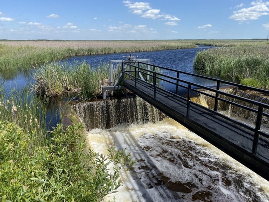 A project team organized by the Middle-Snake-Tamarac Watershed District has developed a plan to replace the aging and inadequate outlet works at Nelson Slough in the state’s East Park Wildlife Management Area. (photo credit: DNR)
Current Project Teams
The map below shows 16 projects that are currently in the planning stages using the project team process. These include flood impoundments, stream channel restorations, improved water-level controls, stream bank erosion controls, among others. Projects that get to the finish line will join the 18 projects constructed since 1998 and three currently in construction - all planned using the project team process. While not every project in the planning stages makes it to construction, those that do carry the assurance that they are designed for success with consensus from landowners, agencies and stakeholders.
For more information, see the FDRWG’s Project Team Handbook (2022) or contact the DNR’s Red River Basin Coordinator.
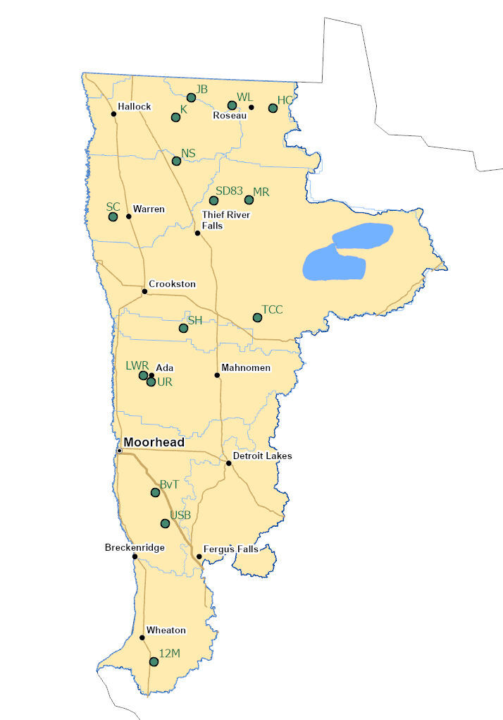 Active project teams:
12M – Twelvemile Creek – Bois de Sioux Watershed District
BV – Barnesville Twp. – Buffalo Red River Watershed District
USB – Upper S. Branch Buffalo River – Buffalo Red River Watershed District
LWR – Lower Wild Rice – Wild Rice Watershed District
UR – Upper Reaches – Wild Rice Watershed District
SH – Sand Hill River Ecosystem Restoration – Sand Hill River Watershed District
MR – Mud River – Red Lake Watershed District
SD83 – SD83/Thief River – Red Lake Watershed District
TCC – Turtle-Cross-Connection Lakes – Red Lake Watershed District
NS – Nelson Slough – Middle-Snake-Tamarack Watershed District
SC – Swift Coulee – Middle-Snake-Tamarack Watershed District
JB – Juneberry – Two Rivers Watershed District
K – Klondike Clean Water Retention – Two Rivers Watershed District
JB – Juneberry – Roseau River Watershed District
WL – Whitney Lake – Roseau River Watershed District
HC – Hay Creek – Roseau River Watershed District
Announcements
-
Klondike Project Approval. The Two Rivers Watershed District and HDR Engineering presented updated information on the Klondike Clean Water Retention Project at the February 2025 FDRWG meeting. The project was approved by consensus, in connection with funding consideration by the RRWMB. The TRWD intends to begin construction in 2026, subject to funding availability from the State.
-
Rural Flood Mapping Project. The new federal administration in Washington DC has terminated a FEMA program called Building Resilient Infrastructure and Communities (BRIC). As a result, FEMA recently cancelled a one million-dollar BRIC grant to the FDRWG and RRWMB. The two organizations had planned to use this funding to map farmland inundated by 10-year summer storms in the Red River Basin. Work on this effort is therefore on hold, pending discussion of options for continuing without the federal funding.
-
Five-Year Monitoring Program. The FDRWG’s second season of field work has begun. A contractor will continue collecting field and laboratory data from nine project sites across the Red River Basin during the spring, summer and fall months.
-
Transitions:
- Ben Bergey was recently named as Director of the Minnesota DNR’s Northwest Region, and Co-chair of the FDRWG. Ben replaces Theresa Ebbenga, who had served as Co-chair of the group since 2019. We welcome Ben to this new assignment while thanking Theresa for her dedication and leadership over the past 5 years.
- Andrew Graham, FDRWG Coordinator for the past six years, is preparing to retire from the Minnesota DNR. His successor, Bethany Bethke started in April and will spend the spring and summer learning the ropes while providing staff support to the Work Group.
-
The next meeting of the FDRWG is scheduled for the morning of May 21, 2025 at the RRWMB office in Ada, MN. For more information, contact the DNR’s Red River Basin Coordinator.
|