|
November 2024
Goose Prairie Marsh Project completed: helps landowners and waterfowl
Goose Prairie Marsh sits near the eastern edge of Clay County, north of Hitterdal, MN. By the 1950s the marsh had a long history as a premier producer of waterfowl, and the State of Minnesota acquired land surrounding the marsh to serve as a Wildlife Management Area (WMA). Since then the State has preserved and managed the wetland area to produce waterfowl, protect other wildlife, and provide public access for hunting and other activities.
Habitat quality at Goose Prairie WMA deteriorated in recent decades as invasive cattails and algae began to dominate the wetland vegetation, bottom-disturbing fish moved in, and water quality declined. This was likely influenced by practices in the watershed upstream that did not account for potential impacts to the marsh.
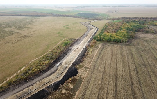
At the same time, maintenance of County Ditch 18 through the marsh proved unfeasible. This ditch was constructed in the last century to drain water from area farmland, but its capacity was gradually reduced as sediment and vegetation accumulated in the ditch. Local farmers lost some of their acreage to high water during a series of wet years in the early 2000s.
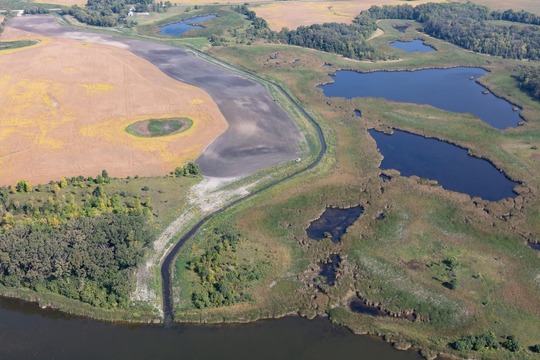 The project includes a new ditch (left) that bypasses productive wetland habitat (right). 2023. Photo credit: HEI.
In 2014 the Wild Rice Watershed District (WRWD) initiated the “Goose Prairie Project Team” to assess opportunities to improve conditions at the marsh. The Project Team process, sponsored by the FDRWG, gathers local landowners, watershed district staff and managers, and participants from state and federal agencies to explore problems and develop solutions in local watersheds within the Red River Basin.
After a series of investigations, the Project Team came up with a viable plan to address the various needs at Goose Prairie Marsh. The plan included four main actions: raising a township road; adding a water-control structure; moving County Ditch 18 out of the marsh; and removing obstacles in the ditch channel downstream from the WMA. These actions were conceived as a joint project of the WRWD and the Minnesota Department of Natural Resources (DNR). The U.S. Fish and Wildlife Service also participated.
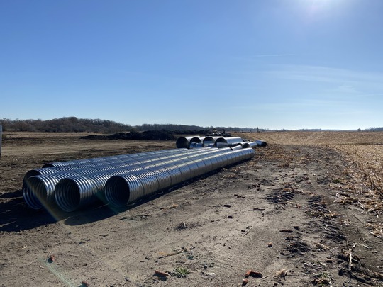 Culverts staged during construction in 2022. Photo credit: DNR.
Collaborative projects to reconfigure land and water resources are typically complex, and this one was no exception. Funding was pieced together from the Watershed District, Red River Watershed Management Board and three separate State funds – all with differing requirements and timelines. The U.S. Fish and Wildlife Service had funded land acquisition for the WMA in the 1950s, so their permission was needed to modify the site. A state easement was required for the ditch realignment. Cooperation with adjoining landowners was essential to facilitate construction access and staging of materials and equipment.
In 2023, ten years after the first meeting of the Project Team, the Goose Prairie Marsh project was completed. The WRWD can now maintain flow through CD 18, and local landowners benefit from annual water-level drawdown that creates 700 acre-feet of flood-storage capacity. The additional storage will help reduce flood peaks on the Red River downstream. The new ability to control water levels will help the DNR improve nesting habitat for waterfowl including canvasbacks, ring-necked ducks, and ruddy ducks. Other birds like grebes, coots, rails, and terns will also benefit. The Goose Prairie project shows what can be accomplished when partners develop a shared vision, create a plan and work together until the job is done.
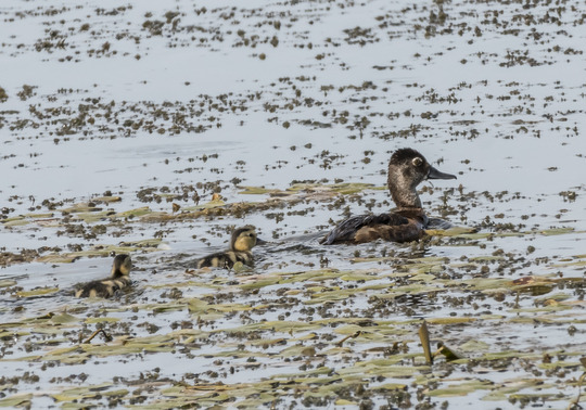 Ring-necked ducks and other waterfowl will benefit from the DNR’s new ability to control water levels at Goose Prairie Marsh. Photo credit: Janet Nelson.
Roseau Lake Rehabilitation project under way
Viewed from the air, Roseau Lake is a massive, elongated circle northwest of the City of Roseau, MN. Natural and straightened channels of the Roseau River cut across the south half of the lake, which was drained a century ago to make the lakebed farmable. Most of those efforts were ultimately abandoned, and today much of Roseau Lake lies within a Wildlife Management Area (WMA) operated by the Minnesota Department of Natural Resources (DNR). Landowners outside the WMA continue to farm in the vicinity. Within the WMA, wetland habitats support a variety of game and non-game wildlife such as mallards, sandhill cranes, sharptailed grouse, yellow rails, white-tailed deer, and the occasional moose.
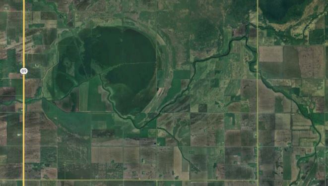 Aerial view of Roseau Lake northwest of Roseau, MN. Photo credit: Google Earth Pro.
The Roseau River floods regularly in the spring and early summer with occasional fall events. Fed by snowmelt in the spring and rainstorms in the summer and fall, the river can quickly rise out of its banks to flood a vast area within the flat landscape of the Red River Basin, including the Two Rivers watershed to the south. This disrupts transportation along local roads, poses challenges for farmers raising crops, and carries harmful sediment and nutrients into downstream waterways.
The Roseau Lake Rehabilitation project began construction of Phase 1 last year. When all phases of the project are completed, it will provide approximately 20,000 acre-feet of managed flood storage. Together with other projects already constructed or in the planning stages, this will help to reduce the harmful effects of flooding in the northern Red River Basin. It will also deliver more reliable and prolonged inundation of the lake basin for waterfowl, shorebirds, and other wildlife to thrive.
 Roseau Lake north embankment under construction, fall 2023. Photo credit: HDR.
In addition to the primary project at the WMA, an associated project in the Lost River State Forest will restore partially drained peatlands through ditch abandonment and plugging in the Sprague Creek Scientific and Natural Area and adjacent forest land northeast of Roseau Lake. Hydrology is vital to maintaining a healthy peatland, and this restoration will provide conditions for the enhancement of native plant richness and abundance in degraded areas along ditch channels that are no longer needed in the SNA.
The Roseau Lake Rehabilitation project is a partnership between the Roseau River Watershed District (RRWD) and the DNR. Phases now complete or nearly so include the northwest embankment and Pine Creek structure, as well as the Pine Creek stream reclamation. The project partners hope to award the next phase this winter for 2025 construction. Current funding has been provided by several sources, including the State’s Flood Hazard Mitigation program, Lessard-Sams Outdoor Heritage Council, Red River Watershed Management Board and RRWD. Roseau County has participated by issuing necessary permits and approving partial abandonment of legal drainage systems in the project area.
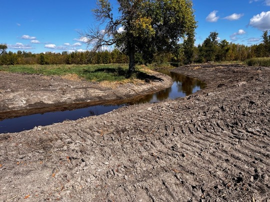 Pine Creek channel restoration (middle reach) in the summer of 2024. Photo credit: HDR.
RRWD Administrator Tracy Halstengard notes that planning for this project began in 2011, and “seeing the first dirt moved in 2023 was a huge milestone.” Project construction is planned to occur in phases, and the completion date will depend on continued funding availability over the next several years.
Announcements
-
Annual Joint Conference to be held in Moorhead on March 18 and 19. Hosted by the FDRWG and Red River Watershed Management Board (RRWMB), participants gather to share information and experiences related to flooding, farming, and natural resources in the Red River Basin. For more information and registration, check the RRWMB website in January.
-
FEMA has approved a grant to map flood inundation in the Red River Basin. Supported by Minnesota’s Department of Homeland Security and Emergency Management, this grant will leverage outcomes of a pilot project funded by the FDRWG and RRWMB in 2023. The new mapping activity will cover certain rural areas not mapped under standard floodplain management procedures. The methods developed have many potential applications for flood damage reduction and emergency management. Counties and watershed districts in the basin are eligible to participate as project partners.
-
The FDRWG’s Five-Year Monitoring Program concluded its first field season in September. Monitoring is being performed by Moore Engineering and the DNR’s Division of Ecological and Water Resources. The International Water Institute is coordinating field activities on behalf of the FDRWG. This work is funded with a grant from the Environment and Natural Resources Trust Fund (ENRTF).
-
The Red River Retention Authority is working on a Strategic Plan using input gained at a “summit” meeting with stakeholders held at East Grand Forks in July 2024.
-
Two ring levees were constructed in 2024 at farmsteads in Polk and Red Lake counties using funds appropriated to the DNR by the State Legislature from the ENRTF. These funds have now enabled construction of four new farmstead ring levees since 2022.
-
The Work Group’s next meeting will be in-person on Wednesday, December 11 at the Prairie Grains Conference in Grand Forks, ND. Contact the Red River Basin Coordinator or check the conference web site for meeting details. Conference registration is not required to attend this meeting.
|