|
May, 2024
Highlights from the Annual Joint Conference
Each year the FDRWG and the Red River Watershed Management Board (RRWMB) hold a joint conference on reducing flood risk and improving natural resources in Minnesota’s portion of the Red River Basin (RRB). This issue of FDRWG Currents highlights a few of the topics covered at the latest conference, held in March 2024.
This year the event had 95 participants from watershed districts, state agencies, consulting firms, regional organizations, counties, federal agencies, and others. There were 20 presentations covering a range of topics such as flood projects, new mapping data and tools, technology, and activities of the FDRWG, RRWMB, and partner agencies and organizations. Anishinaabe speaker Bob Shimek provided a personal view of the Red River Basin’s history, waters and wildlife. A panel shared career experiences, and attendees played Family FeudTM together. For many, the best part of the event came through informal conversations over breakfast and lunch, in hallways, and after hours.
To plan for attending the 2025 Conference, see the Announcements below. For highlights from the 2024 technical presentations, read on.
New Mapping Capabilities for Vulnerable Land
Flood mitigation projects in the Red River Basin are engineered carefully to achieve specific goals serving local and regional needs. In farmland outside of urban areas, a typical goal is to manage flooding from summer storms that cause crop damages, especially when flooding inundates actively growing crops for more than 24 hours. The 1998 Mediation Agreement that guides FDRWG activities established an objective of “providing protection against a ten-year summer storm event for intensively farmed agricultural land.”
The “10-year” storm refers to rain events with a 1-in-10 statistical chance of occurring in any given year at a particular site. These storms are both smaller and more frequent than the “100-year” storm events commonly used to plan flood projects in urban areas where a higher (and more expensive) degree of flood protection is necessary.
Flooding caused by 10-year storms doesn’t only affect farmland – it also affects thousands of miles of local roads throughout the RRB. Those roads can be blocked by floodwater, impeding day-to-day travel as well as emergency vehicles serving the public. In extreme cases, culverts and road embankments can be undermined or eroded, requiring expensive repairs once flood waters subside.
The Mediation Agreement used a standard definition for the 10-year storm: 3.57 inches of rain falling within 24 hours. At the time, the exact locations and extent of farmland inundated by these storms was not known and developing this information across the entire basin was prohibitively expensive. Recent advances in Geographic Information Systems (GIS) and flood-modeling tools, coupled with availability of highly detailed ground surface elevations from the RRWMB’s 2021 LiDAR project, brought mapping of these areas within reach. In 2023 the RRWMB and FDRWG teamed up to explore multiple methods to map 10-year storm inundation areas in farmed regions of the RRB.
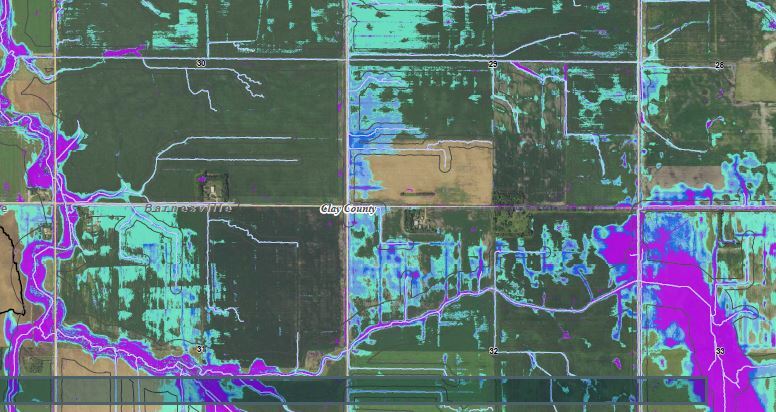
Two pilot areas were selected: the Whisky Creek drainage in Clay County and the Swift Coulee drainage in Marshall County. Methods investigated included a GIS tool that relies solely on topography and local stream characteristics (“flattened stream” method); a flow-routing approach that breaks down watersheds into many contributing catchments (“discharge mapping” method); and a tool that combines GIS data with powerful two-dimensional modeling software (HEC RAS 2D or “rain-on-grid” method).
The RRWMB and FDRWG hired a consulting team comprising the International Water Institute (IWI) and Houston Engineering, Inc. (HEI) to develop these methods for application to the RRB. This team summarized the three methods developed and presented initial map outputs at the 2024 Joint Annual Conference hosted by the FDRWG and RRWMB. Some outputs are shown below.
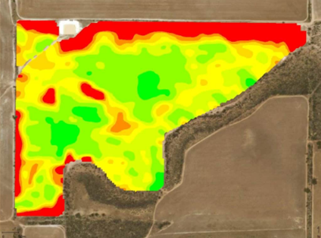
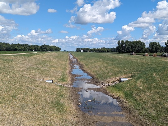
 Depth of inundation from 10-year storm, Whisky Creek subwatershed. Results preliminary. (Credit: IWI/HEI)
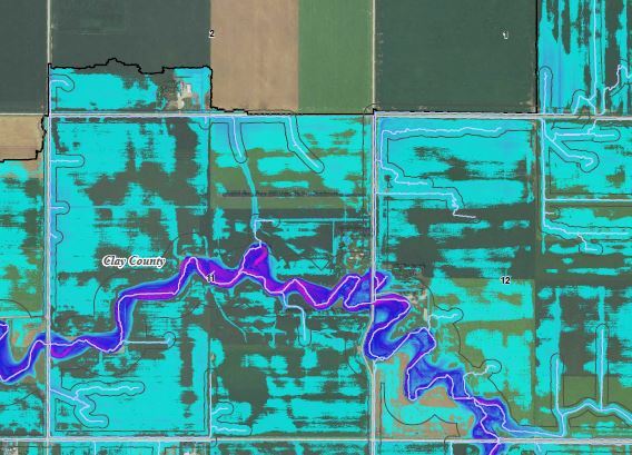
 Duration of inundation from 10-year summer storm, Whisky Creek subwatershed. Results preliminary. (Credit: IWI/HEI)
In the coming months, the RRWMB and FDRWG will review these new tools and consider how they may be applied to additional areas across the RRB. As this is developed further, methods and outputs will be shared with watershed districts, county governments, and others that manage water resources or road networks across the region.
RRWMB Funding Aids Water Quality Projects
The Red River Watershed Management Board (RRWMB) recently completed a review of its Water Quality Program that was launched 4 years ago. The Program contributes funding to member watershed districts for programs or projects that enhance water quality in the Red River Basin of Minnesota. Since 2020, the availability of this funding has extended the reach and scale of water quality efforts of member districts beyond what would have been possible without the RRWMB's assistance.
 Rock drop structures that control erosion in a diversion ditch leading to the Red Lake Watershed District's Black River Impoundment. (Credit: RLWD/HEI)
The review report lists 27 awards ranging from $100,000 to $1.2 million. Fourteen of the awards have been fully used while 13 are currently in progress. The total funding awarded through the end of 2023 was over $6 million. Funding is pooled with local resources plus dollars from other state and federal programs to purchase equipment, carry out field investigations, acquire easements for ditch buffers, stabilize and re-plant ditch banks, rehabilitate stream channels, and install side-inlet culverts.
 Judicial ditch 75 with stabilized banks and side-inlet culverts that reduce sediment inputs. (Credit: MSTRWD)
The RRWMB funding awards have contributed to projects that reduce delivery of at least 6,800 tons per year of sediment and 1,700 pounds per year of phosphorus to area waters. Water bodies benefitting from these improvements extend across the basin from Lake Traverse in the south to the Roseau River in the north. They include:
Lake Traverse
Mustinka River
Rabbit River
Doran Creek
Red River
Wild Rice River
Black River
Grand Marais Creek
Red Lake River
Roseau River
Hay Creek
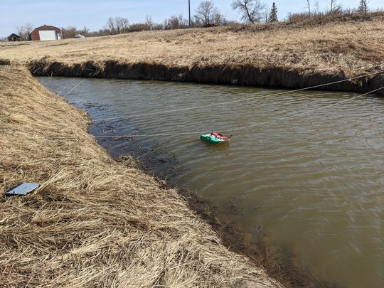 TRWD's acoustic doppler current profiler in action. This equipment was purchased with assistance from the RRWMB. (Credit: TRWD)
Grants are now being awarded for 2024. Ongoing participation by the RRWMB’s member districts suggests that benefits to area waters will continue to accrue for many years to come.
The full Water Quality Program Summary Report, with district-by-district awards and outcomes, is available on-line from the RRWMB.
IWI Stewardship Program Supports Farm-level Decisions
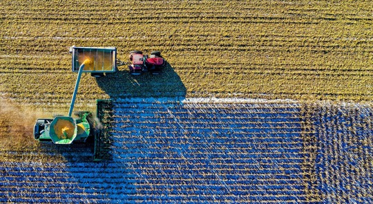 Harvesting grain in the Red River Basin. (Credit: IWI)
As they take to the fields in Spring 2024, farmers in the Red River Basin have a new “implement” they can hitch to their tractors. The International Water Institute (IWI), based in Fargo, has developed a software tool that enables farmers to upload information specific to their fields and operations to calculate how soil and water stewardship practices will affect their bottom line come fall. The farmer-friendly software, called WayfindrTM generates a Field, Farm, or Farmer Stewardship Rating (FSR) and allows farmers to understand the environmental outcomes from their farming operation and how changing the operation to improve the environmental outcomes will affect the financial bottom-line.
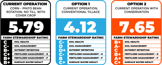 Examples of farm stewardship ratings based on operation options. (Credit: IWI)
IWI and its funding partners Cargill Global Water Challenge and The Mosaic Company conceived of the project in 2019, developed a prototype in 2021 and tested it with RRB farmers in 2022. The software is now available for deployment across the region.
IWI’s project lead David Kramar notes that the method applies key principles from IWI’s Stewardship Program: “It’s voluntary, led by farmers based on their interests, and applies an economic lens to water, soil, and nutrient stewardship decisions on the farm.” WayfindrTM generates useful data to decide, for example, whether to adjust tillage practices, plant cover crops, or incorporate grassed waterways. This makes it easier for farmers to assess how those practices will affect environmental outcomes and the profitability of their business operations, while reflecting their own values around stewardship.
Field-level maps can show the change in net financial return from a given conservation practice. (Credit: IWI)
To use WayfindrTM, the farmer begins by entering data on their current crop production, fertilizer application methods, input costs like fuel and fertilizer, expected commodity prices, and net return. Current tillage and water management practices are compared to “benchmarks” represented by alfalfa forage (high stewardship rating) and moldboard plowing (low stewardship rating). The farmer can then enter alternate practices to see how both the economic returns and the stewardship rating changes. Ratings include water retention in the soil, runoff volume, soil erosion, phosphorus mobilization from fertilizers, and impacts in downstream water bodies. The financial outputs eliminate guesswork in considering different options for the stewardship practices.
IWI staff are available to assist with data input. The farm data are secure and only the farmer can access his/her results. A data non-disclosure agreement is available upon request.
For more information, contact IWI’s Charles Fritz, email: charles@iwinst.org, or phone: 701.388.0861.
FDRWG Announcements
NEW! Videos available. The FDRWG recently developed two 5-minute videos that provide an overview of its purposes and activities, as well as information on projects developed using the Project Team process. The two videos can be viewed on the FDRWG web site. Scroll below the page titles to find "FDRWG Overview" and "FDRWG Projects" videos. To view them, click on the "play" icon, then click the "full-screen" icon within the video display.
NEW! Flood Funding Prioritization Document. The Minnesota Department of Natural Resources' Flood Hazard Mitigation Program awards cost share funding to local governmental units around the state to plan, design, and implement flood risk reduction measures. DNR recently developed a document that explains the statutory considerations that go into the DNR’s prioritization decisions in each funding cycle. This document can be used as a reference for watershed districts and other local governments applying for funds from the FHM program.
DNR Reports on Hydrologic Change. Significant increases in precipitation and runoff occurred in many Minnesota rivers in the 1990s and persist to the present time. The DNR has produced watershed-specific reports that use historical streamflow data to assess the timing and magnitude of changes in runoff patterns for streams across the state. These include nine rivers in the Red River Basin: the Buffalo, Clearwater, Otter Tail, Red Lake, Roseau, Sand Hill, Thief, Two Rivers, and Wild Rice Rivers. To locate these reports on the web site link above, browse by “HUC 4” (select Red River) then scroll down the left panel to find the Publication Series filter (select “Evaluation of Hydrologic Change [EHC]”). Next, look for “Body of Water” and click on “Show More” to see the full list of rivers covered in the RRB. Selecting one of these will open up the report for that river.
Cost-share grants remain available for rural and farmstead ring levees in the Red River Basin. To be eligible, ring levees must be sponsored by public entities like watershed districts, tribes, or counties. Projects can be constructed on private land. All work funded by these grants must be completed by June 30, 2025. For more information visit the DNR’s FHM Program web page.
The next Annual Joint Conference will be held March 18-19, 2025, in Moorhead. If you have not attended before and would like to receive information on registration, contact the RRWMB at 218-784-9500, or DNR’s Red River Basin Coordinator.
The FDRWG’s contractor Moore Engineering began field work in April for the new Five-Year Monitoring Program. This work is funded by the State’s Environment and Natural Resources Trust Fund (ENRTF) and will provide data to help the FDRWG plan new projects across the RRB. Further information will be provided over the next several field seasons.
Upcoming meetings of the FDRWG are scheduled for June 20 and September 18, 2024, in Ada, MN.
|