|
May 2023
Highlights from the Annual Joint Conference
Each year the FDRWG co-sponsors a conference with the Red River Watershed Management Board to highlight activities, methods and funding to reduce flood risk and improve associated natural resources in Minnesota’s portion of the Red River Basin. This issue of FDRWG Currents highlights a few of the topics covered at the conference held in February 2023. For more information on the 2023 conference or next year’s event, contact the Minnesota Department of Natural Resources' (DNR) Red River Basin Coordinator (see contact information below).
Farmer finds benefits in soil health
Featured presentations by J. Wiegandt and A. Cates as part of a soil health panel
Can the way a farmer manages soil be good for the bottom line while helping to solve water resource problems in the Red River Basin (RRB)? According to Jared Wiegandt who farms near Larimore, North Dakota, the answer for the past five years has been “yes.” Wiegandt shared his experiences as a member of a panel that presented current trends involving “soil health.” According to Wiegandt, no-till practices have made it easier to work the fields in the spring, lowered fuel costs and increased profitability on his family’s farm.
“When I joined my parent’s farm in 2012, we didn’t value soil health," said Wiegandt.
But after experiencing deep mud in the fields during wet times and watching wind scour their soil in dry times, he began experimenting with a cluster of practices to change that.
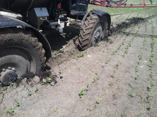
Before Wiegandt began experimenting with soil health practices, getting equipment stuck in the mud was a frequent problem. (Photo credit: J. Wiegandt)
What is soil health? Anna Cates, assistant extension professor, University of Minnesota Dept. of Soil, Water and Climate, says it can be boiled down to a simple statement: “Soil health is the continued capacity of the soil to function as a vital, living ecosystem.” This helps crops utilize nutrients while reducing water stress.
Cates' presentation emphasized practices like keeping the soil covered for as much of the year as possible, minimizing cultivating and soil compaction to allow soil structure to develop over time, increasing crop diversity, keeping living roots in the ground, and integrating livestock into the crop production cycle where feasible. Cates shared images based on recent research that showed how these practices dramatically increase pore spaces within soil at the microscopic level. This allows water to enter and exit the soil more readily and promotes microbial activities that enable crop roots to absorb nutrients more effectively.
 Source: C. Gasch
On the Wiegandt farm near Larimore, the focus has been on using cover crops to keep the soil covered, and no-till practices to avoid soil disturbance and compaction. Time that used to be spent extracting tractors and equipment from deep mud can now be spent on productive activities during the intense work periods in the spring and fall. Reducing fuel consumption lowers operating costs and contributes to a net increase in profitability per acre. The characteristics in the different areas on the Wiegandt farm vary, and the best practices need to be matched to localized soil characteristics, drainage and other conditions.
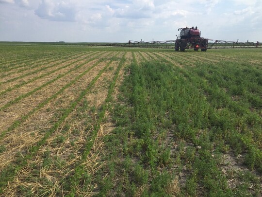 New soybean field seeded with no-till into a prior planting of rye that was harvested. Area on right did not receive the rye planting and shows weed growth between rows. (Photo credit: J. Weigandt)
As farmers like Wiegandt adjust their operations, will there be a payoff for water resources in the Red River Basin? The acreage under soil health practices is currently a tiny fraction of agricultural land in the region, but State programs are in place to gradually increase them. While models point to watershed-scale benefits of these practices, more research is needed to quantify water storage benefits of soils health practices in the RRB. Wiegandt is just glad his farm’s operations and profitability are improving. “We’ve learned a lot since 2012,” he said.
Conference attendees also heard from two Minnesota Soil and Water Conservation Districts (SWCDs) about funding available for local farmers to invest in soil health practices at the county level in Minnesota. For more information, contact your local SWCD or a Board Conservationist with the Minnesota Board of Water and Soil Resources (BWSR). The FDRWG’s Technical Paper No. 3: “Best Management Practices for Controlling Runoff from Agricultural Land” (2021) also provides information on these practices.
Project Team seeks solutions at Agassiz NWR/Mud River watershed
Presentation by J. Graham and N. Dalager
In 2021 the Red Lake Watershed District (RLWD) formed the Mud River Project Team to work on habitat quality and sediment delivery problems affecting the Agassiz National Wildlife Refuge (NWR). Situated within the Thief River Basin in Marshall County, Agassiz NWR sits at the downstream end of the Mud River. True to its name, the river delivers a substantial sediment load to the NWR, and over the years this has built mud flats dominated by invasive hybrid cattails.
Refuge Manager Jim Graham cites data showing that sediment deposition has reduced water storage capacity by thousands of acre-feet* since the 1940s. Invasive cattails provide poor habitat for waterfowl, so Graham hopes a solution can be found that will reduce the influx of sediment while improving habitat conditions on refuge lands.
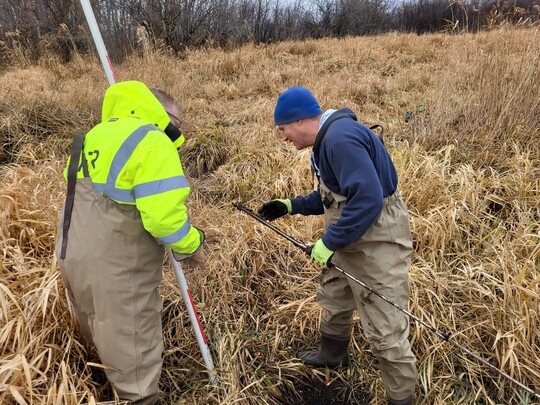 Nate Dalager, HDR (left), and Corey Hanson, RLWD (right), take soil samples along a former channel of the Mud River. (Photo credit: HDR Engineering)
"Managing sediment entering the refuge is critical to the long-term health of refuge wetlands," said Graham. "By using a watershed-based approach and developing a project that enhances natural processes, we anticipate benefits not only to the refuge habitat but also for water quality and flood damage reduction in the Thief River watershed.”
The project team process organizes key participants and stakeholders across multiple levels of government and the private sector to seek viable solutions to flooding and natural resource problems in the Red River Basin. Approximately two dozen projects have been planned using this procedure over the past 25 years. Myron Jesme, Administrator of the RLWD said his Board of Managers strongly supports using this procedure to solve problems in the watershed.
“The project team process has been very successful in developing projects over the past 25 years, so the District hopes we can once again get consensus that helps satisfy the purposes of this project,” Jesme added.
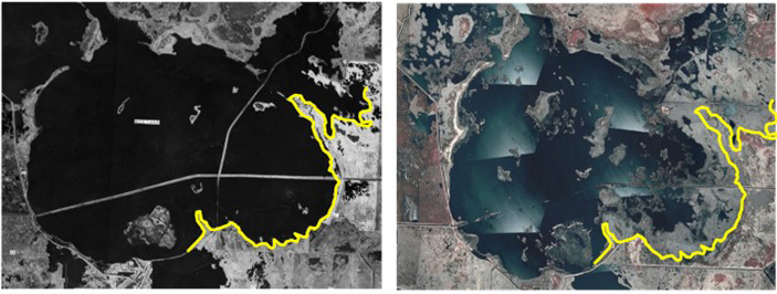 Aerial photos from 1948 (left) and 2006 (right) show how sediment inputs and associated cattails have diminished the main pool at Agassiz NWF. (Source: USFWS)
The Mud River Project Team includes the U.S. Fish and Wildlife Service (USFWS), RLWD, Marshall County, four State agencies, local landowners and the City of Thief River Falls. A professional facilitator is helping the group work through the project planning effort, with financial assistance from the FDRWG.
At the FDRWG/RRMWB conference in February, the RLWD’s consulting engineer Nate Dalager (HDR) emphasized the value of being open to different ideas that can emerge from project team discussions. Input from the group, he says, has helped to guide field investigations, modeling objectives, and consideration of alternate solutions, while clarifying how federal land, state land, and private agricultural land in the Mud River watershed are interrelated.
The Project Team’s work will continue through the spring and summer of 2023. If a viable solution is identified, the effort will transition to designing project features and seeking funding for construction.
For more information on the Project Team process, see the Project Team Handbook (2022) available on the FDRWG website.
*One acre-foot is the volume of water held on an acre of land to a depth of one foot. This is about 325,000 gallons and is similar to the amount that could be stored to a depth of one foot on a 100-yard football field.
Cost-share grants available for rural ring levees
The DNR is overseeing distribution of grants for construction of ring levees to protect farmsteads, rural homes, businesses or other rural sites in the Red River Basin. Watershed districts, local governments and tribes are eligible to receive the funds on behalf of local landowners needing assistance. The state funding from the Environment and Natural Resources Trust Fund (ENRTF) covers 50 percent of the cost of design and construction.
After accounting for other public funds that may be available locally, the cost to a private landowner can be 25 percent or less of the total project cost. For more information, contact the DNR’s Red River Basin Coordinator (see contact information below). A request for proposals and the grant application form are available through the DNR’s Flood Hazard Mitigation program. Grants are limited.
FDRWG Announcements
- The Two Rivers Watershed District (TRWD) recently completed the environmental review process for the Klondike Clean Water Retention Project. An Environmental Assessment Worksheet was released in January 2023. After the close of the comment period, the TRWD Board of Managers determined that an Environmental Impact Statement is not needed.
- Responding to a petition filed by the Roseau River Watershed District (RRWD), The Roseau County Board of Commissioners approved partial abandonment of the Judicial Ditch No. 61 drainage system in March 2023. This action advances development of the Roseau Lake Rehabilitation Project.
- In March the FDRWG approved two technical support grants for the Wild Rice Watershed District (WRWD). These will support development of project alternatives by the Upper Reaches Project Team and Norman-Polk Project Team. The initial funding award was $21,000 for the two projects. An additional $41,500 in funds requested by the WRWD remains pending for consideration in the next fiscal year.
- The FDRWG is seeking a consultant/contractor to assist with mapping of 10-year floodplains in the Red River Basin. A Request for Qualifications was released recently by the Red River Watershed Management Board acting as the FDRWG’s fiscal agent.
- Upcoming meetings of the FDRWG are scheduled for June 14 and September 20.
|