|
February 2023
Newsletter for Strategic Land Asset Management (SLAM)
This staff newsletter provides information and updates on the department's Strategic Land Asset Management (SLAM) program.
In This Issue
 Written by Mollie Gudim, information officer, Lands and Minerals Division
Public land sales are more than transactions.
For one Hmong family, the opportunity to purchase parcels of land from the DNR is a chance to connect to their cultural heritage and honor traditions tied to nature. “Hmong people are independent and self-sufficient, but we will always need nature,” said Tong Xiong, who immigrated to Minnesota from a refugee camp.
Prior to emigrating from Southeast Asia, generations of Hmong people lived in the mountains of Laos, responsibly using land for agriculture and farming. Water was a spiritual element used for healing. “I was brought up on the teachings of my elders who lived from the land to sustain themselves,” said Xiong, who vowed to own private land so that his family’s lifestyle in Minnesota would remain deeply rooted in the natural elements of Hmong culture.
Fortunately, the DNR’s land sale program made it possible for Xiong to purchase parcels of state land that no longer met the agency’s conservation, recreation, or economic goals, but helped his family find a sustainable way to continue the traditional agrarian lifestyle of harvesting crops and hunting big game. In recent years, Xiong has purchased state land in northern and southern Minnesota. “I’m very thankful to the DNR for helping us grow a family-owned land base,” he said, adding that the plan is to build a hunting camp and plant vegetable gardens on the property.
Hmong culture is centered around family, and once they resettled in Minnesota, Xiong spent a lot of time in nature helping his father and uncle gather food for their table. English is his fourth language, and it was difficult to understand the rules of hunting on public land.
“We relied on relatives who came to Minnesota before us to show us where we could hunt and fish,” he said. Today, owning private land also means that the family’s older generations – and younger ones, too – can access nature easily and without barriers.
“By design, DNR’s mission is a reflection of the natural environment’s linkage between many values, traditions, and livelihoods,” said Andrea Johnson, land sale coordinator for the Lands and Minerals Division. “The Xiong family’s success is just one example of the important role that public land sales can play in creating unique opportunities for all people to reap the physical, emotional, and cultural benefits of nature.”
Now that he’s older and his children are grown, Xiong knows that buying public land is part of leaving a legacy. “Our land will help the next generation appreciate the Hmong way of life,” he said.
DNR land sale program
Land sales help the DNR contribute to Minnesota's quality of life by coordinating the statutory and program requirements to sell state owned lands that no longer meet conservation or recreation needs or are isolated from larger management areas or parcels.
In 2022, the DNR held in-person auctions in October in Wadena and Rochester followed by a December online auction through the Department of Administration’s MinnBid auction site. Eleven properties from Wadena, Itasca and St. Louis counties received bids, totaling 229 acres sold. Proceeds from several properties sold will be deposited into the Permanent School Fund, benefitting every K-12 school district in the state.
Editor's Note: The Xiong family has asked that their story only be shared internally to the DNR.
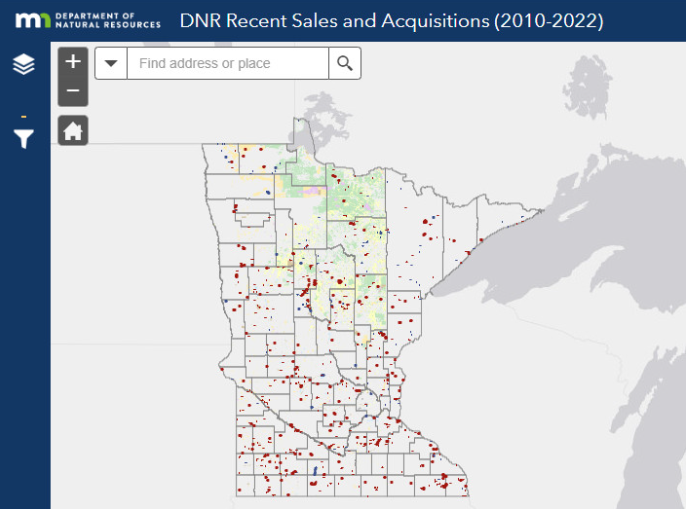 Do you want to quickly find out which division administers a certain land parcel, or what a given parcel’s land type might be?
Check out DNR’s improved public-facing SLAM webpage, which now hosts two interactive web applications. The DNR land maps and data will help DNR deliver clear understanding about Minnesota’s public lands, and the department's management strategies.
New webpage features
The Minnesota Land Portfolio is made up of interactive maps that display DNR’s land portfolio by land type, including state-owned school trust lands, acquired lands, consolidated conservation lands, and tax forfeit lands. Each map includes narrative text with details about the background and history of DNR’s ownership of each land type.
DNR administered lands web app provides a dynamic overview of DNR land assets, highlighting fee surface sales and acquisitions from 2010 to 2022. The app includes details about each parcel, including whether the state obtained ownership through a congressional grant, a deed, or a patent.
The SLAM Program team will be facilitating user testing for the web apps to identify areas to improve user experience, functionality and, above all, usefulness. Reach out to Kerstin Larson or Mollie Gudim if you have suggestions for improving these new resources.
 Written by Cheri Zeppelin, information officer, NE region
DNR’s Heritage Forest Project team is nearing the completion of its assessment of former Potlatch industrial forestlands scattered across 14 counties in northern and central Minnesota. The team has identified about 15,000 acres of high-priority parcels in nine of those counties for potential state acquisition.
The project team completed their land analysis by using SLAM metrics to rank available parcels against a defined set of management criteria. County-based teams were employed to tap local staff expertise to identify local needs and opportunities, and they have been instrumental in early coordination with local governments.
Project manager and NW Region Forestry Manager, Adam Munstenteiger, credits the SLAM program for providing the Heritage Forest Project team with a solid foundation from which to work. “Having a clear set of metrics up front has enabled the team to more swiftly complete the parcel winnowing process, while also communicating our strategic goals to our partners and stakeholders,” he said.
To date, five counties and numerous townships have offered support for the state to acquire lands within their boundaries, and plans are being finalized to meet with the remaining local governments units.
Local governments have generally been supportive of DNR’s goals to maintain public access, conserve working forests and wildlife habitat, and protect water quality with this acquisition. The team is beginning to piece together a funding package from a variety of potential funding sources and expects to begin the appraisal process soon.
 DNR began requiring early county coordination for new acquisitions a few years ago, but there was no shared definition of “early county coordination” which caused confusion among staff. The results were wasted time in rework, internal frustration with the process, and strained relationships with counties and land acquisition partners.
Using the tools learned in Lean Six Sigma Green Belt training, an interdisciplinary project team identified key challenges in county coordination and developed several process improvements to address those challenges that were rolled out earlier this month:
- DNR now communicates with acquisition partners earlier in the process flow.
- DNR now develops acquisition-specific county engagement plans for certain high-risk acquisitions using a consistent and accessible template.
- The team reduced the number of process steps in the early county engagement process from 21 to 13.
- The team created a central location to host and share historical information about DNR-county relationships.
After implementing the changes in the northwest region, DNR staff and partners saw such an improvement in the quality of county engagement and relationships that project sponsors decided to roll out the project statewide.
If you have questions about when you might need to develop an early county coordination plan for a land acquisition project, talk to your division acquisition coordinators:
|
Division Land Acquisition Coordinator, Forestry
|
Jeff Busse
|
|
Division Land Acquisition Coordinator, Forestry
|
Christine Ostern
|
|
Division Land Acquisition Coordinator, Fish & Wildlife
|
Jeff Tilma
|
|
Division Land Acquisition Coordinator, Parks & Trails
|
Shelby Kok
|
|
Division Land Acquisition Coordinator, Fish & Wildlife
|
Rick Walsh
|
|
Division Land Acquisition Coordinator, Ecological & Water Resources
|
Bill Bleckwenn
|
|
