Weekly Drought Update - Sept. 13, 2021
Key Points in this Update
Drought conditions and management actions:
- As of September 7:
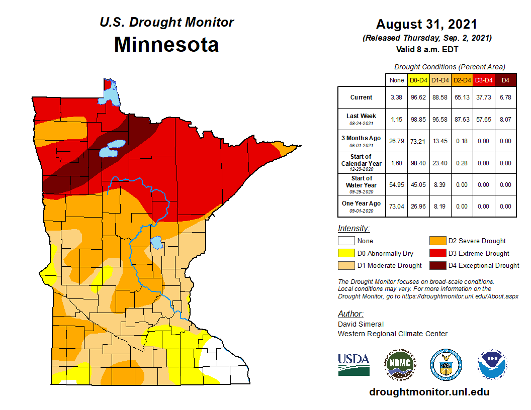
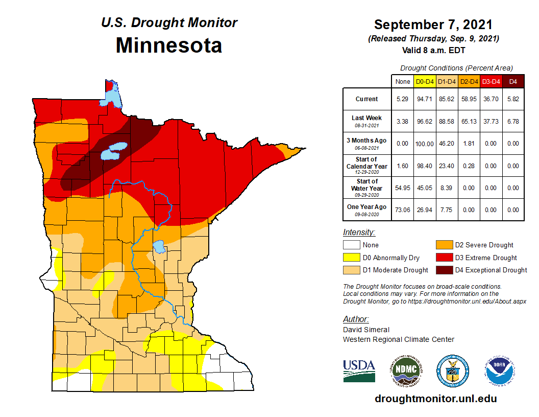
- Twenty-two percent of Minnesota is experiencing severe drought (down from 27 percent last week).
- Thirty-one percent is experiencing extreme drought (about the same as last week).
- Six percent is experiencing exceptional drought (down from seven percent last week).
- The state continues in the Drought Warning Phase. The Rainy River and the Red River watersheds remain in the restrictive phase.
- As of Sept. 9, the DNR has received 22 well interference complaint forms in six counties.
Streamflow management actions:
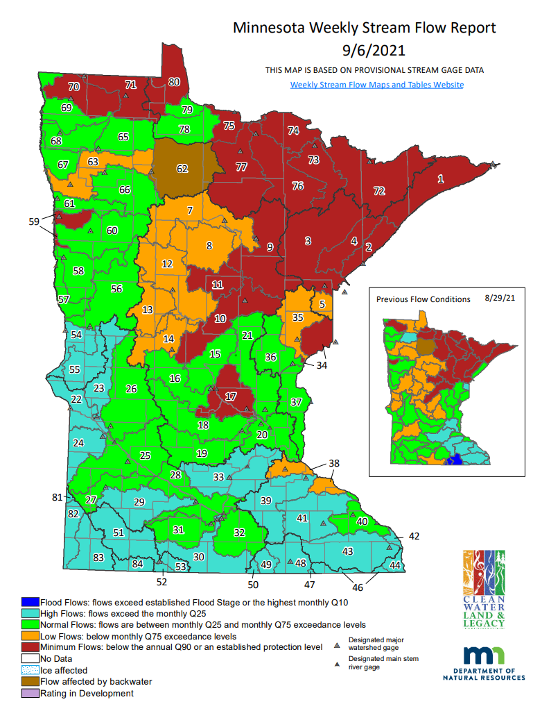
- 19 out of 81 total major surface water watersheds are below the Q90.Five watersheds dropped below their respective Q90 (minimum flow) this week. One watershed has experienced increased flow and is now above the minimum flow (Q90) threshold after being below in the previous week.
- 231 surface water appropriation permits out of 517 reviewed for potential permit suspension are currently suspended across 27 watersheds throughout the state.
- 8 surface water appropriation permits in the Bois de Sioux River and Mustinka River watersheds were reinstated after flows increased above the Q90 including the cumulative instantaneous total of all suspended appropriations from contributing surface water sources within the watershed.
Fire management actions:
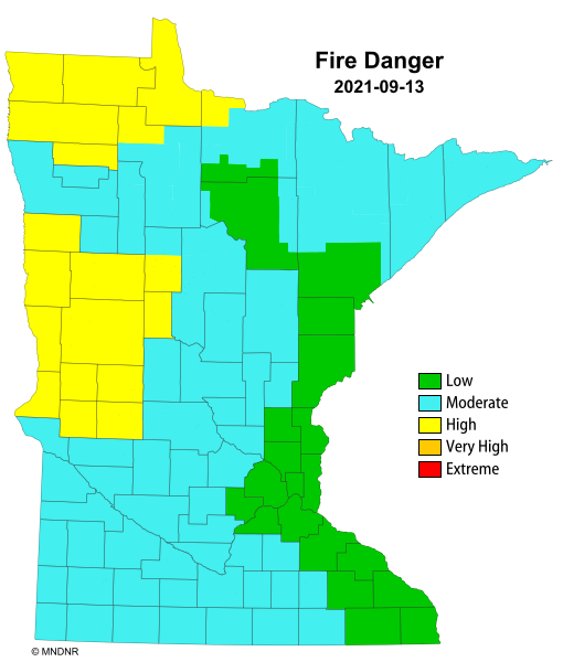
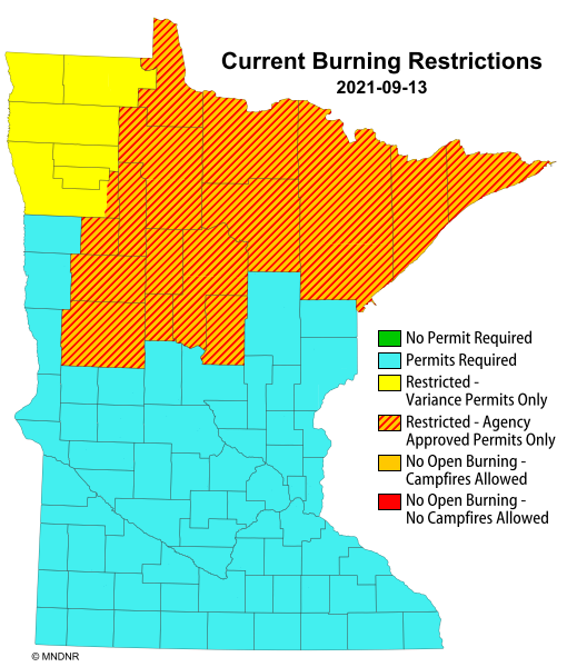
- As of September 13, fire danger remains high in some northwest and west-central counties.
- As of September 13, burning permits are still required in all counties. Burning restrictions are in place over much of the northern half of the state.
- As of September 13, the Greenwood Fire, 10 miles southwest of Isabella, is at 26,797 acres in size (41 square miles) and is 67% contained.
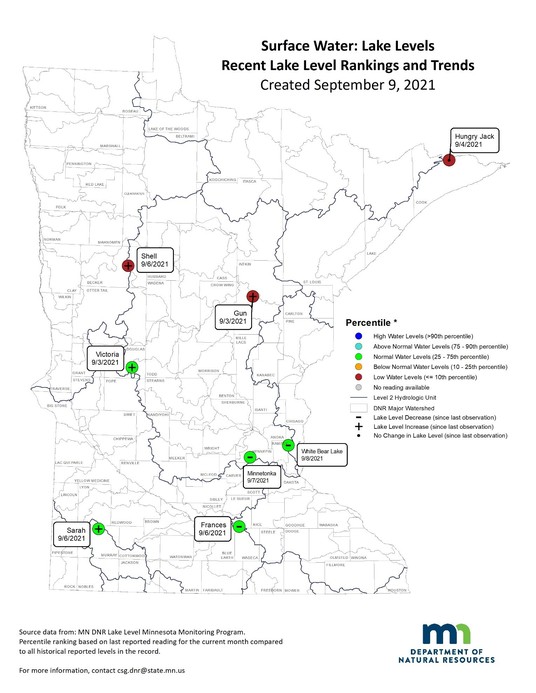
Sample Lake Level situation:
- Four of the eight reporting lakes increased from the previous week, from 0.24 to 4.44 inches.
- Three of the eight reporting lakes decreased from the previous week, from 0.12 to 0.96 inches.
- One of the eight lakes stayed the same from the previous week.
- Three of the eight lakes remain in the low range.
- Five of the eight lakes are in the normal range.
Drought Information
Last two weeks of Drought Maps:
  Links to the maps:
Drought Analysis and Recommendations:
Drought situation:
- Counties with an area of exceptional drought (D4): 9
- Counties with an area of extreme drought (D3): 25
- Counties with an area of severe drought (D2): more than 40
- Counties with an area of moderate drought (D1): All counties except for two have at least some moderate drought.
- Counties just abnormally dry (D0 – not drought): 9
- Counties with no designation: 2
- Estimated population in Drought Areas: 4,464,642
Drought management actions:
- The state remains in the drought warning phase of the Statewide Drought Plan.
- The Rainy River and the Red River watersheds continue to experience extreme to exceptional drought and water suppliers remain in the restrictive phase.
- As of Sept. 9, DNR has received 22 well interference complaint forms in six counties. See DNR Well Interference webpage.
- 17 are active investigations.
- One was found valid.
- One was found not valid.
- One was dismissed.
- Two were resolved early by the appropriator.
- The DNR has received 31 verbal complaints, four of which were resolved by nearby appropriators.
Streamflow Information
 Link to the map:
Streamflow Analysis and Recommendations:
Streamflow situation:
- Watersheds at minimum flow (below Q90): 19 watersheds (Lake Superior – North, Lake Superior - South, St. Louis River, Cloquet River, Mississippi River-Grand Rapids, Mississippi River – Brainerd, Mississippi River – St. Cloud, Upper St. Croix River, Marsh River, Two River, Roseau River, Lake of the Woods, Rainy River – Headwaters, Vermillion River, Rainy River – Rainy Lake, Rainy River – Manitou, Little Fork River, Big Fork River,)
- Watersheds at low flow: 9 watersheds are experiencing low flow.
- Watersheds at normal flow: 27 watersheds are experiencing normal flow conditions.
- Watersheds at high flows: 26 watersheds are experiencing high flows.
Streamflow management actions:
- 231 surface water appropriation permits are currently suspended across 27 watersheds including the St. Louis River, Cloquet River, Mississippi River – Brainerd, Pine River, Crow Wing River, Redeye River, Rapid River, Rainy River – Baudette, Sand Hill River, Little Fork River, Rainy River – Headwaters, Big Fork River, Rainy River – Manitou, Mississippi River – Grand Rapids, Red Lake River, Clearwater River, Thief River, Wild Rice River, Roseau River, Lake of the Woods, Two River, Mississippi River – Sartell, Sauk River, Lake Superior – North, Mississippi River – St. Cloud, Snake River, Lower St. Croix River, Mississippi River – Lake Pepin, and Watonwan River watersheds.
- Five watersheds dropped below the Q90 within the last week. Two watersheds increased above the local Q90.
- Other permit actions in watersheds at minimum flow (below the Q90) include:
- Bois de Sioux River (No. 54) and Mustinka River (No. 55): 8 surface water appropriation permits were reinstated on September 8, 2021. Flows at the designated stream flow gage at Doran increased significantly above the Q90 within the last week enough to reinstate the suspended permits.
- Watonwan River (No. 31): 15 surface water appropriation permits were suspended on August 25, 2021. Flows at the designated stream flow gage near Garden City continue above the Q90 within this week.
- Mississippi River – Lake Pepin (No. 38): 9 surface water appropriation permits were suspended on August 25, 2021. Flows at the designated stream flow gage in Empire continue above the Q90 within this week.
- Snake River (No. 36) and Lower St. Croix River (No. 37): 16 surface water appropriation permits were suspended on August 24, 2021. One surface water appropriation permit holder is implementing their contingency plan through the use of a groundwater well in lieu of their surface water appropriation. Flows at the designated stream flow gage near Pine City continue above the Q90 this week.
- Mississippi River – St. Cloud (No. 17): 25 surface water appropriation permits were suspended on August 24, 2021. Four surface water appropriation permit holders are implementing their contingency plan through the use of a groundwater well in lieu of their surface water appropriation.
- Lake Superior – North (No. 1): 2 surface water appropriation permits were suspended on August 17, 2021.
- Red Lake River (No. 63): 15 surface water appropriation permits were suspended on August 4, 2021. Flows at the designated stream flow gage in Crookston continue above the Q90, but not enough to reinstate suspended permits.
- Clearwater River (No. 66): 14 surface water appropriation permits were suspended on August 4, 2021. Flows at the designated stream flow gage at Plummer continue above the Q90 this week.
- Roseau River (No. 71): 1 surface water appropriation permit was suspended on August 2, 2021.
- Wild Rice River (No. 60): 6 surface water appropriation permits were suspended on August 2, 2021. Flows at the designated stream flow gage at Twin Valley continue above the Q90 this week.
- Thief River (No. 65): 2 surface water appropriation permits were suspended on August 2, 2021. One surface water appropriation permit was reinstated on September 2, 2021.
- Mississippi River – Sartell (No. 15) and Sauk River (No. 16): 46 surface water appropriation permits were suspended on August 1, 2021. Four surface water appropriation permit holders are implementing their contingency plan through the use of a groundwater well in lieu of their surface water appropriation. Flows at the designated stream flow gage near St. Cloud continue above the Q90 this week.
- Little Fork River (No. 76): 3 surface water appropriation permits were suspended on July 28, 2021.
- Rainy River – Headwaters (No. 72): 1 surface water appropriation permit was suspended on July 28, 2021.
- Rainy River – Manitou (No. 75) and Big Fork River (No. 77): 2 surface water appropriation permits were suspended on July 28, 2021.
- Mississippi River – Grand Rapids (No. 9): 19 surface water appropriation permits were suspended on July 27, 2021.
- Sand Hill River (No. 61): 8 surface water appropriation permits were suspended on July 24, 2021. Flows at the designated stream flow gage in Climax continue above the Q90, but not enough to reinstate suspended permits.
- Mississippi River – Brainerd (No. 10) and Pine River (No. 11) watersheds: 21 surface water appropriation permits were suspended on July 13, 2021.
- Rapid River (No. 78) and Rainy River - Baudette (No. 79) watersheds: 3 surface water appropriation permits were suspended on July 13, 2021. Flows at the designated stream flow gage on the Roseau River near Malung increased above the Q90, but not enough to reinstate suspended permits.
- Louis River (No. 3) and Cloquet River (No. 4) watersheds: 6 surface water appropriation permits were suspended on July 11, 2021. Additionally, 3 permits have contingency plans to modify their appropriation under the existing permits.
- Crow Wing River (No. 12) and Redeye River (No. 13): 17 surface water appropriation permits were suspended on June 28, 2021. Flows at the designated stream gage at Nimrod continue above the Q90 this week.
- The Marsh River watershed (No. 59) does not have any surface water appropriation permits and flows continue to be below the Q90.
- The Vermillion River (No. 73) and Rainy River – Rainy Lake (No. 74) watersheds include only two non-consumptive water-use permits, resulting in no suspensions.
- The Lake of the Woods (No. 80) watershed does not have any surface water appropriation permits.
- The DNR will reinstate permits when the average daily flow exceeds, for at least 72 hours, the Q90 plus the cumulative instantaneous total of all suspended appropriations from contributing surface water sources within the watershed. Consideration of anticipated precipitation or lack thereof is also a factor in determining when to reinstate suspended permits.
- We continue to watch the changing streamflow conditions and suspend or reinstate surface water appropriation permits where and when necessary.
Fire Danger and Management
  Links to the maps:
Fire Danger Analysis and Recommendations:
(Fire danger conditions can change daily based on local meteorological variables. Information presented illustrates a real-time snap shot of current conditions on September 13.)
- Counties with Extreme Fire Danger: 0
- Counties with Very High Fire Danger: 0
- Counties with High Fire Danger: 19
- Fire management actions:
- As of September 13, fire danger remains high in some northwest and west-central counties.
- As of September 13, burning permits are still required in all counties. Burning restrictions are in place over much of the northern half of the state.
- As of September 13, the Greenwood Fire, 10 miles southwest of Isabella, is at 26,797 acres in size (41 square miles) and is 67% contained.
- Campfires are allowed in most fee campgrounds only.
- See Superior National Forest webpage for current fire information.
Lake Water Levels
 Analysis and Recommendations
Lake Level situation depicted on the map above:
- Four of the eight reporting lakes increased from the previous week, from 0.24 to 4.44 inches.
- Three of the eight reporting lakes decreased from the previous week, from 0.12 to 0.96 inches.
- One of the eight lakes stayed the same from the previous week.
- Three of the eight lakes remain in the low range.
- Five of the eight lakes are in the normal range.
The DNR LakeFinder non-mobile website is the best means to access available lake level elevations for individual lakes. Search by county, the lake’s name, or 8-digit identification number for the lake, then click the Water Levels report. The Lake Water Level report page contains all available lake levels, highest and lowest lake levels, and a 10-year graph. All the reported historic and current lake elevations can be downloaded for viewing or copied to a spreadsheet for graphing and other functions.
|