Water Talk Newsletter - Summer 2018
August 29, 2018
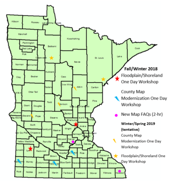
NOTE: Some trainings are first week of September 2018, so RSVP right away if interested in attending those locations.
Three types of workshops are scheduled:
-
County Modernization Workshops – One day workshop offered by DNR and FEMA staff as part of the County Map Modernization effort. The communities in the county select the topics, but the workshops are open to all. Some offer two tracks.
-
Basic Floodplain and Shoreland Workshop – A one day workshop covering floodplain and shoreland basic and advanced topics. Two tracks are normally offered.
-
New Map FAQs – Two hour workshop in counties with new FEMA maps going effective within a few months.
The following workshops have been scheduled (and topics for the County Modernization Workshops are listed):
-
September 5, 2018 (Wed), 8:45 am – 4 pm, Pipestone Emergency Services, Pipestone; County Modernization Workshop (8:45-10:15 Floodplain Basics; 10:25-11:25 Floodplain Administration or Shoreland Basics; 12:10-1:40 Using FEMA Digital Data in ArcGIS format or Advanced Floodplain Administration [Nonconformities, CUPs, floodproofing]; 1:50-2:50 Accessing Web Based Sites or Mitigation Grants; 3-4 Floodplain Culverts or Flood Preparations)
-
September 6, 2018 (Thu), 8:45 am – 4 pm, Emergency Operations Center, 136 S Cordova Ave, Le Center; County Modernization Workshop (8:45-10:15 Floodplain Basics; 10:25-11:50 Accessing Web Based Sites; 12:35-2:05 Using FEMA Digital Data in ArcGIS format; 2:15-4 Variances and Nonconformities [variances in floodplain & shoreland; floodplain nonconformities])
-
September 7, 2018 (Fri), 8:45 am – 4 pm, Watonwan Human Services, St. James; County Modernization Workshop (8:45-10:15 Floodplain Basics or HEC-RAS viewing model input/output; 10:25-11:50 Interpreting Floodplain Maps [determine RFPEs, etc.] or HEC-RAS modifying the model; 12:30-1:20 Floodplain Administration Basics or Flood Preparations; 1:30-2:30 Accessing Web Based Sites or Mitigation Grants; 2:40-4 Communicating Flood Risk [interactive session])
-
September 11, 2018 (Tue), 1:00 – 3:00 pm, Houston Community Center, Houston; New Map FAQs for Local Officials & Professionals (surveyors, consulting engineers/planners, realtors, lenders, etc.)
-
September 18, 2018 (Tue), 10 am – noon, Carver County Government Center, Chaska; New Map FAQs for Local Officials & Professionals (surveyors, consulting engineers/planners, realtors, lenders, etc.)
-
December 18, 2018 (Tue), 8:45 am – 4 pm, Elk River City Hall; Basic Floodplain and Shoreland Management Training
- December 20, 2018 (Thu), 8:45 a.m. - 4 p.m., MERIT Center, Marshall; Basic Floodplain and Shoreland Management Training
Communities all over Minnesota have been effected by flooding this summer, including just days ago in SE Minnesota. Impacted communities and the Minnesota Division of Homeland Security and Emergency Management (HSEM) have been very busy with response to damages caused by the flooding.
See the HSEM web site for the latest information on disaster response and recovery around the state.
Confused about state and federal disaster declarations? Read a short summary of the disaster declaration process on the HSEM site.
Recent updates:
Request for Presidential disaster declaration for Public Assistance
Governor Mark Dayton requested a Presidential disaster declaration on August 7, 2018 for Public Assistance. Federal assistance was requested to help cover reimbursement for damage expenses in the counties of Aitkin, Beltrami, Blue Earth, Brown, Carlton, Cass, Clearwater, Cottonwood, Faribault, Itasca, Jackson, Kanabec, Koochiching, Lake, Lyon, Martin, Murray, Nicollet, Nobles, Pine, Pipestone, Polk, Redwood, Renville, Rock, St. Louis, Sibley, and Watonwan, and the tribal governments of the Leech Lake Band of Ojibwe, Red Lake Nation, and White Earth Nation.
See a copy of Governor Dayton’s Presidential disaster request letter.
Small Business Administration (SBA) Declaration in SW Minnesota
The U.S. Small Business Administration (SBA) has a separate declaration process. The SBA just issued an Administrative Declaration for Minnesota on August 28, 2018. The SBA will be working with Lyon and Redwood County emergency management officials to identify locations to establish Disaster Loan Outreach Centers (DLOC) to delivery their disaster loan assistance programs. More information will become available for Lyon, Redwood and contiguous counties.

Mark your calendars for the 2018 Minnesota Association of Floodplain Managers annual conference, November 14-16. This year’s conference will be held at the City Center Hotel in downtown Mankato. For news and notifications, please sign up for the MNAFPM mailing list on the bottom of the MNAFPM website. Exhibitor and sponsor registration is available now, and conference registration will be available soon. As in previous years, there will be an opportunity to take the Certified Floodplain Manager (CFM) exam on the last day of the conference.
|
By Ceil Strauss, MNDNR, State Floodplain Manager
Unfortunately, we hear this way too often. A home or business owner recognizes they have flood risk, asks their agent for a flood insurance quote, and are told they cannot get a flood insurance policy since they are in the lower risk zone on the FEMA Flood Insurance Rate Map (FIRM).
Reality: That is NOT true. You can get flood insurance in any zone!
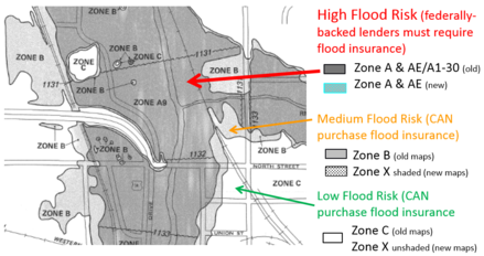
Those with structures in the Special Flood Hazard Area (SFHA) – an A, AE, A1-30, AO or AH Zone (and V Zones in coastal areas) - who have a federally backed loan will be required by their lender to purchase flood insurance. But anyone can voluntarily purchase flood insurance in the SFHA (the high risk zone), the medium risk zones (shaded Zone X, or Zone B on older maps) and the lower risk zone (unshaded Zone X, or Zone C on older maps).
|
As long as the community participates in the National Flood Insurance Program (NFIP), anyone in that community can purchase flood insurance. Over 95 percent of Minnesotans live in a community that participates in the NFIP! You can check FEMA’s Community Status Book for Minnesota to see if your community is in the participating list. (There are also many communities in Minnesota that do not have mapped flood risk, and do not participate in the NFIP. However, ALL communities can and are encouraged to enroll in the NFIP; flooding has occurred all over the state in communities with no mapped high flood risk that got eight, ten, or even twelve or more inches of rain.)
Floods Don't Stop at the 100-Year Floodplain Boundary (or, Floods Don't Read FEMA maps)
Those near FEMA mapped high risk floodplains, or near locally recognized high flood risk areas, are especially encouraged to purchase flood insurance. Statistically, those right at the boundary of the 100-year floodplain (or the 1% annual chance floodplain) have a 26% chance of being flooded over the 30 years of a typical mortgage, so those just outside of the mapped area still have up to a 25% chance of flooding. Statistically, those at the very edge of the 500-year floodplain have a 6% chance of flooding over 30 years, a greater likelihood than fire in most areas.
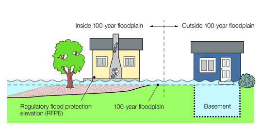
The home just inside the 100-year floodplain has a 26% chance of flooding over a 30 year mortgage. The home just outside the 100-year floodplain boundary has a 25% chance of flooding over a 30 year mortgage. Graphic: © MNDNR
And we are seeing changes in weather patterns. More of our rain is coming in storms of greater than two inches. In fact, the MNDNR Climatology office now talks about "Mega-Rains." Mega-Rains are events in which six inches of rain covers more than 1000 square miles and the core of the event topped eight inches. Of the 11 historical Mega-Rain events in Minnesota since 1973, eight occurred in the 2000s and 2010s.
Discounted Preferred Risk Policies (PRPs) available in low and medium risk zones
Those purchasing flood insurance in the medium and lower risk zones (Zones B, C and X) are usually able to get the discounted “Preferred Risk Policy” (PRP). A PRP can be purchased for as little as ~$200/year for $20,000 building/$8,000 contents coverage, and the maximum residential property coverage of $250,000 building/$100,000 contents is ~$600/year. In fact, over 55 percent of flood insurance policies in Minnesota are PRPs for structures in medium or lower risk areas. Twenty-five to 30 percent of flood insurance claims are in the lower risk areas, and more recent reports estimate that over 50 percent of flood damage occurs outside of the mapped high risk areas.
Visit www.floodsmart.gov for more information about flood insurance.
By Ceil Strauss, MNDNR, State Floodplain Manager
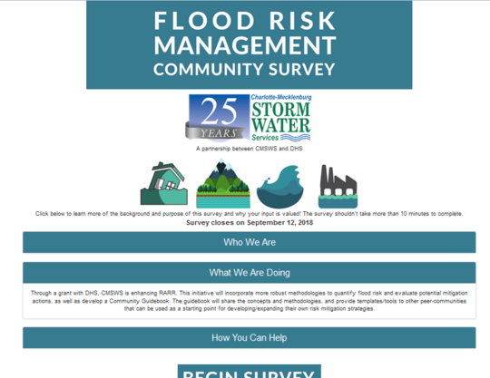
Many of you community officials saw my August 3rd email encouraging you to complete the survey and give input from your community's perspective. Thanks to the 83 Minnesota communities (currently most of any state!) that have already taken the survey and given input.
The survey should only take 10-15 minutes. It asks about the relative number of structures at risk for flooding in your community, what data you have available, how your community prioritizes flood risk reduction options, etc. It also asks for your input on what format would be most helpful for the Community Flood Risk Guidebook.
Home page of ManageFloodRisk.org site
Visit www.ManageFloodRisk.org for more background on the project and to take the flood risk survey.
By Ceil Strauss, MNDNR, State Floodplain Manager
In late June 2018 FEMA launched the new Flood Map Changes Viewer (FMCV). This public interactive map viewer allows the user to zoom in and see preliminary and pending (will be effective within six months) map data layers with an aerial background.
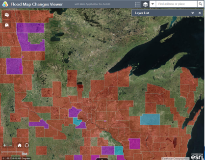
Minnesota counties that can currently see their maps on this new viewer:
- Preliminary Maps: Fillmore, Marshall, Polk, Scott, Wright & Yellow Medicine.
- Pending Maps (effective within 6 months): Carver & Houston.
|
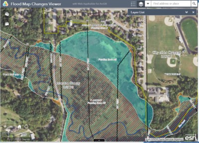
These interactive maps are much nicer to review than the preliminary panels. You can enter an address, pan and zoom as with most interactive maps, and see the flood zones, regulatory floodways, Base Flood Elevations (BFEs), and cross-sections.
Sample view of pending map (effective within a few months).
|
A few tips for using FMCV:
- In the preliminary maps, the Base Flood Elevation (BFE) elevations only appear at certain scales (usually 600 feet and 0.2 mile scales).
- Some locations have administrative floodways. On the preliminary maps the “administrative floodway” label is visible, but the floodway shading is not visible.
-
The “Map Changes report” is intended to show the current mapped flood hazard zone versus the preliminary flood hazard zone for the “pinned” location. Since the current maps are all paper (not digital) for the preliminary map counties currently in the viewer, the effective map just has dots noting the area does not have modernized effective maps. Note: The “Map Changes” report does not work in pending map counties.
For More Information
See links to other useful FEMA viewers and DNR sites at MNDNR Access Floodplain Maps site.

The National Flood Insurance Program (NFIP) was originally set to expire September 30, 2017. There have been short extensions to December 8, 2017, December 22, 2017, January 19, 2018, and July 31, 2018. The most recent extension expires on November 30, 2018.
See links to the latest updates and more information about NFIP reform and other topics of interest to floodplain managers at the Association of State Floodplain Managers (ASFPM) site.
|
|