Water Talk Newsletter - Spring 2018
May 16, 2018
By Ceil Strauss, MNDNR, State Floodplain Manager
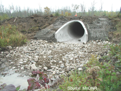
You are the local zoning authority and you hear the township is planning to replace culverts at two locations within A Zone areas on your community's Flood Insurance Rate Map. Do you need to issue permits in accordance with your floodplain management regulations?
Source: MNDNR
See answer at bottom of this newsletter.
|
By Diane Lynch, Administrator, Prior Lake – Spring Lake Watershed District
|
|
 |
As if starting her new job as the District Administrator for the Prior Lake-Spring Lake Watershed District just one month before a nearly 250-year flooding event wasn’t difficult enough, little did Diane Lynch know that she would still be working on flooding damages nearly four years later. Over 13 Inches of rain fell over a short period in June, causing local flooding of homes and streets and overwhelming the Prior Lake Outlet Channel.
Damages From 2014 Flooding
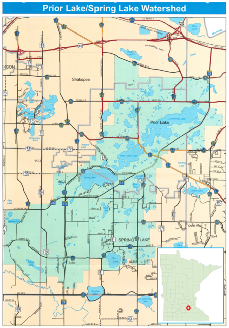
The Prior Lake Outlet Structure and Channel was built in 1983 primarily for stormwater conveyance for land-locked Prior Lake in Scott County. The part constructed/part natural channel meanders its way over 7 miles to the Minnesota River.
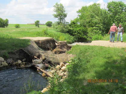
During the June 2014 rain events, it is estimated that the lake level of Prior Lake could have reached approximately 912.26 feet without the outlet structure; whereas it peaked at 906.17 (compared to an ordinary high water, or OHW, of 903.9). During this time, the channel suffered extensive damage from downed trees, major bank erosion and formation of a large sediment delta.
|
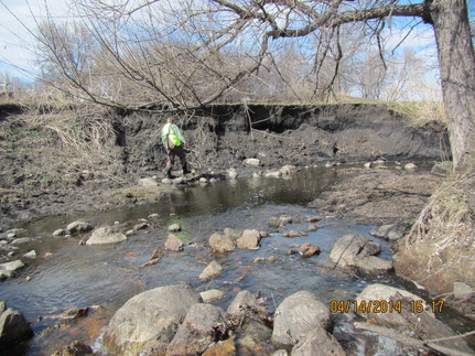
All of this damage was estimated to cost nearly $1 million. The downed trees, culvert and sediment delta repair projects are completed. The bank erosion project is now underway and all projects received FEMA funding.
|
Planning Process to Reduce Future Flooding Impacts
Several months after the flood, the City of Prior Lake and the District met to develop plans that would help mitigate the impacts of future flooding. The Stormwater Management and Flood Mitigation Study process was created and implemented in cooperation with Spring Lake Township beginning in 2015 and was completed at the end of 2016. Barr Engineering was retained to conduct the Study, which included updating the modeling of the watershed, reviewing flood-related issues and projects, identifying and evaluating potential flood reduction strategies, and recommending implementation options.
Public Outreach
Public outreach was an integral part of the study. There were three public input meetings; two Advisory Group meetings (representatives from community groups); two Joint Policy Group meetings (elected/appointed officials from the City, Township and District) and one Farmer Listening Session.
Narrowing the Options
Out of 20 viable alternatives that were investigated, the Policy Group selected three that met the following goals: to protect public safety and maintain emergency access, to protect public utility infrastructure, to maintain traffic flow through the County Road 21 corridor, and to maintain access to private properties.
The three alternatives selected were:
- Actively manage the Prior Lake Outlet
- Create a Prior Lake Flood Response Policy (both short-term goals)
- Secure upper watershed storage (long-term goal)
|
Actively managing the Prior Lake Outlet was the responsibility of the District. Therefore a procedure was developed to analyze weather forecasts, storage capacity of existing wetlands and lakes, and consider flooding potential. The DNR-approved Manual was updated to allow the Outlet Structure’s low flow gate to be opened more often, not just in response to spring snowmelt.
The City of Prior Lake created a Flood Response Policy designed to protect public safety by implementing protective measures triggered at critical Prior Lake levels, such as deploying signs and equipment, offering sandbags for sale, and deploying temporary flood protection measures in critical locations.
Securing upper watershed storage was the responsibility of the District. Potential flood storage areas were identified that could provide flood damage reduction in addition to providing water quality improvement benefits. Potential storage areas are currently being carefully considered where landowners are willing partners.
See the full Prior Lake – Spring Lake Watershed District Stormwater Management and Flood Mitigation Study or the Prior Lake – Spring Lake Watershed District web site for more information about the entire project.
Photos and watershed map source: Prior Lake - Spring Lake Watershed District

Mark your calendars for the 2018 Minnesota Association of Floodplain Managers annual conference, November 14-16. This year’s conference will be held at the City Center Hotel in downtown Mankato. For news and notifications, please sign up for the MNAFPM mailing list on the bottom of the MNAFPM website. Exhibitor and sponsor registration is available now, and a call for abstracts will go out in early summer. As in previous years, there will be an opportunity to take the Certified Floodplain Manager (CFM) exam on the last day of the conference.
|
By Ceil Strauss, MNDNR, State Floodplain Manager
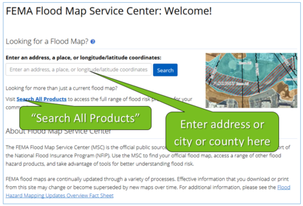
FEMA’s Map Service Center (MSC) had major updates in February 2018. Most of the changes are improvements. While some of the changes are big, others are more subtle.
First Step
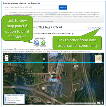
At the MSC home page you can either enter an address (or a city or county), or go directly to "Search All Products."
(See more on the "Search All Products" option below.)
|
|
 |
What You See Next Depends on Whether FEMA Maps are Paper or Digital
Newer FEMA floodplain maps (those issued since 2003) are digital, produced at the countywide level, and called Digital Flood Insurance Rate Maps (DFIRMS).
Older FEMA Flood Insurance Rate Maps (FIRMs) are only available as paper maps, or digital scans of the map panels. The maps from the late 1990s or early 2000s may be countywide, but most older maps show cities and the unincorporated county areas separately.
You can see the current status of counties in Minnesota - which either have DFIRMs, paper maps, or no FEMA map - at the MNDNR Access Floodplain Maps site.
Next Step with Digital Flood Insurance Rate Maps (DFIRMs)
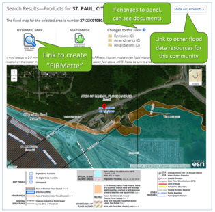
New Features for DFIRM Counties
- Bigger interactive map shows flood zones and data on either aerial or road background
- Data layers from FEMA's National Flood Hazard Layer (NFHL) are updated daily
- "Dynamic Map" link - click on this to create a "FIRMette" (official copy of FEMA map)
- Legend greatly expanded
- Previous link to National Flood Hazard Layer (NFHL) viewer no longer available
Retained Features
- Link to other flood data for that community
- Can zoom in and out on the interactive map
- In the folders above the interactive map there are copies of any revalidation letters, Letters of Map Amendments, etc., relevant to that map panel.
|
Sample of New FIRMette Produced with "Dynamic Map" Link
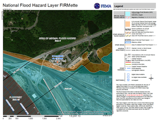
New FIRMette features:
- Ability to locate "pin" on building or location of interest
- Data layers from FEMA's National Flood Hazard Layer (NFHL)
- Letters of Map Revisions (LOMRs) are incorporated on day they are effective
- Uses aerial background and NFHL layers that have colors and formatting most find easier to interpret
- Expanded legend
Features retained from the original FIRMettes (that are still used for paper maps):
- Official copy of FEMA floodplain map that can be printed or saved as a pdf
- Scale is the same as the official FEMA map panel (and cannot be changed)
Next Step for Paper Map Counties
|
For paper map counties, the MSC site is virtually unchanged.
- The interactive map is a bit bigger, and the default background is now the aerial, with a toggle to the roads background
- The same links are available to download a scan of that panel or to view map panels and create FIRMettes, and the feature to create paper map FIRMettes is essentially unchanged since it was first introduced in 2002.
- There is a link to "Show All Products"
|
Data at "Show All Products" or "Search All Products" Links
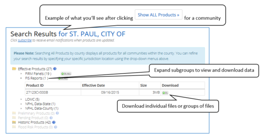
Data available after clicking "Show All Products" includes current effective, historical, preliminary, and pending (effective within months) panels, Flood Insurance Studies (FIS), and Letters of Map Changes (LOMCs).
In DFIRM counties the NFHL data (shape files) are available for that county and statewide.
The "Search All Products" link from the MSC home page takes you to search options. You can search for products in a community or county and get a similar search result as that shown above for St. Paul, or search for specific products (i.e., if you know a Letter of Map Amendment case number).
For More Information
See "Using FEMA's Map Service Center for communities with DFIRMS" and “ Using FEMA's Map Service Center for communities with older, paper-based maps,” and other related information at the MNDNR Access Floodplain Maps site.
By Matt Bauman, MNDNR Floodplain and Shoreland Planner
Communities are subject to DNR notification requirements for certain local government permit applications and ordinance amendments. These requirements are triggered for actions related to floodplain (FP), Wild and Scenic River (WSR), Lower St Croix Riverway (LSCR), Mississippi River Corridor Critical Area (MRCCA), and shoreland (SL) districts. These notification requirements may pose some challenges for administrators, so we want to outline a few tips for improving the practices for outreach your community has in place – in terms of what information is sent, who at the DNR to send it to, how to send it, and when to send it.
State rules detail these requirements, and the specifics differ between the different programs. These rules require local governments to submit public hearing notices to the DNR for variances, conditional uses, plats and PUDs, as well as amendments to the ordinance. The following table summarizes the notification requirements for each District.
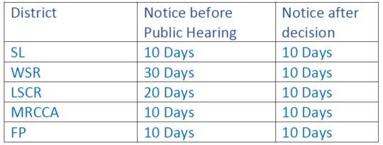
Tips for Notifications
Most communities just want a simple, all-encompassing notification procedure that will satisfy the law and provide an opportunity to get good constructive feedback. We offer a few suggestions:
- Send all notifications to the Area Hydrologist by email
- Do not send the DNR notices for variances and conditional uses unless they pertain to District standards.
-
The notice should provide information on the applicable District, the type of application or action, and the reason for the application or action.
-
For notices dealing with plats and PUDs, send preliminary and final plats, site plans or other documentation showing the proposed development
-
While early notification is recommended for all notifications, this is especially true for amendments to the District ordinance. Review typically requires some level of back and forth, and providing adequate time for review will help to ensure you can get conditional approval prior to the public hearing.
Early Coordination Encouraged
The notification periods provided above outline what is required, but administrators are encouraged to contact the DNR earlier for complex proposals. Ten days’ notice is just not enough time to review and make effective comments for complex issues. DNR can offer technical resources for addressing situations where ordinance interpretation may not be clear. Early engagement will help develop solutions that withstand appeals. Quite often, significant investments have been made on the part of the applicant by the time the required notifications are sent, and any project changes or appeals can result in sticky and costly situations that could have been avoided with earlier engagement.
Administration of these programs is much smoother when there are open lines of communication with the DNR. Technical assistance questions are always welcome, and early communication can often eliminate unforeseen challenges.
By Ceil Strauss, MNDNR, State Floodplain Manager
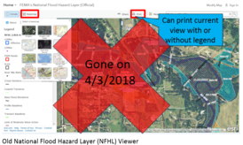
If you've tried to go to FEMA's National Flood Hazard Layer (NFHL) viewer site since 4/3/2018, it's likely you ran into a dead end as the previous link no longer works. There is a new site that has several helpful features, but many of the old features have changed or been removed.
New NFHL Viewer Location
Since the previous site is no longer available, you'll need to save the new National Flood Hazard Layer (NFHL) link. Also, there is no longer a link to the NFHL viewer from the Map Service Center (MSC) site. (See more about the recent changes to the MSC site in this newsletter.)
MNDNR has links to the new NFHL viewer, the Map Service Center (MSC) site and other useful resources on the Floodplain Management Program’s Access Flood Maps page.
|
Useful Features on New NFHL Viewer
Finding Letters of Map Change (LOMCs)
- Letters of Map Amendments (LOMAs), Letters of Map Revisions based on Fill (LOMR-Fs), etc. can be viewed and downloaded (similar to old NFHL site)
- LOMCs are NOT in the default view. To view: (#1) click on "Layers" in upper right, (#2) Expand "NFHL," and (#3) check "LOMAs."
- To view a LOMA (or LOMR-F, etc.) determination: (#4) click on dot by case number (usually purple), and when the pop up box appears for that LOMA (#5) use "Download Letter Here" option.
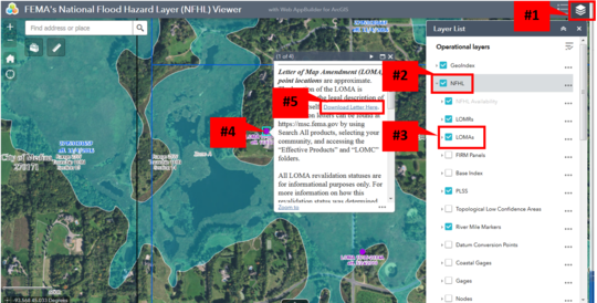
Steps to view and download Letters of Map Amendments (LOMAs) and Letters of Map Revisions based on Fill (LOMR-Fs); Source: Adapted from FEMA NFHL Viewer
Other Layers Can Be Viewed or Turned Off:
- Other layers can be turned on or off in a similar way to the LOMCs. Depending on where you are looking in Minnesota, what scale you are looking at, or whether layers are blocking what you'd like to see, it may be helpful to turn different layers on or off.
- Viewing "Nodes" - On some watercourses (e.g., Minnehaha Creek) where modeling was done with models that don't have typical cross sections, you'll want to turn on the "Nodes" layer.
Features No Longer Available on NFHL Viewer
At past state level floodplain trainings we showed some useful features available on the old NFHL viewer that are no longer available:
-
Background Options - The old site had many background options (including road layer and USGS Quad layer) and allowed the user to go between those layers. The new site only shows the aerial imagery, and changes to a road layer when zoomed in.
-
Printing Options: (1) Printing at a variety of scales is no longer an option. Only the FIRMette can be printed (at the original map scale). (2) Printing with chosen layers showing is no longer an option. GIS must be used, or the user can grab screen shots or use the Snipping Tool.
|
For More Information
See “FEMA National Flood Hazard Layer Tutorial” and other related information at the MNDNR Access Floodplain Maps site.

FEMA's FloodSmart.gov was unavailable for many months, but has now returned with a new look and feel.
FloodSmart continues to be a great source for all topics related to flood insurance.
|
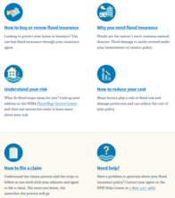
See information on:
- Why you need flood insurance
- How to buy or renew flood insurance
- Understanding your risk
- How to reduce your cost
- Preparing for flooding
- How to file a claim
There are also links to FEMA map information and other related resources.
Note: The previous "Find an Agent" feature worked well in much of Minnesota, but not in many other parts of the country, so it was not returned.
|
By Matt Bauman, MNDNR Floodplain and Shoreland Planner
Regulating bluffs is difficult but important because the presence of a bluff triggers standards dealing with structure setbacks, vegetation management and land alterations. Interpreting and communicating bluff definitions to land owners is often the primary challenge. Once understood, a professional surveyor can usually measure and identify a bluff in the field. Certainly folks can simply play it safe and stay away from anything steep, but that is often not practical. It is helpful for both the applicant and the administrator to know exactly where bluffs exist – if at all.
The ease in interpreting bluff definitions depends largely on the wording of the definition itself. Defining a bluff as a percentage slope is the first element. In addition to a specific percentage, slopes should also be defined as a feature that either rises or runs a specific distance (usually measured in feet) so one can measure and communicate slopes using any of the different methodologies.
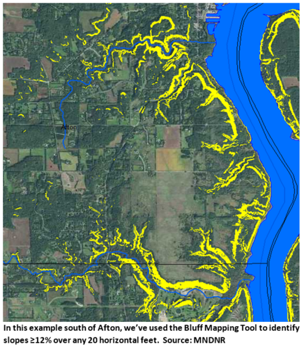
The DNR has a couple of tools to help administrators identify where a bluff may be present, both of which are available at the bottom of the DNR’s Bluff and Slope Protections webpage. GIS users can use the Bluff Mapping Tool, which is an ArcMap extension that analyzes a Digital Elevation Model to map slopes of any steepness based on a given horizontal and/or vertical parameter (as shown in the image on the left). For non-GIS users, this page also has a link to a guidance document for analyzing bluffs using MnTOPO. Both methods will provide fairly accurate “planning level” estimates of slopes. A field survey should always be conducted to establish bluff setback lines prior to permitting any structure, vegetation management or land alteration activity near bluffs.
|
Surveys are expensive and typically paid for by the applicant. A good administrator should be communicating the risks and appropriate standards, and be consistent in determining when they will require one. These tools can serve as the foundation for making such a determination. For example, in shoreland areas, a bluff exists anytime there is a slope ≥30% over any 25 vertical foot rise. Considering there’s a certain level of error in desktop methods, a community may want to consider requiring a survey whenever the tool reveals a slope greater than 25%. This way, you’re being safe and consistent, and setting a clear threshold to enforce this standard.
During the pre-development, consultation phase of a project, proper communication is very important, and these tools provide two effective methods for articulating bluff risks.

The National Flood Insurance Program (NFIP) was originally set to expire September 30, 2017. There have been short extensions to December 8, 2017, December 22, 2017 and January 19, 2018. The most recent extension expires on July 31, 2018.
See links to the latest updates and more information about NFIP reform and other topics of interest to floodplain managers at the Association of State Floodplain Managers (ASFPM) site.
|
Have you heard the often cited “For every $1 spent on mitigation, there is a $4 return of avoided losses in the future?” That's a good benefit-cost ratio, but the source for that figure was recently updated. The updated report says mitigation funding can save the nation $6 in future disaster costs, for every $1 spent on hazard mitigation, and the benefit-cost ratio is $7:1 for riverine flood risk reduction projects!
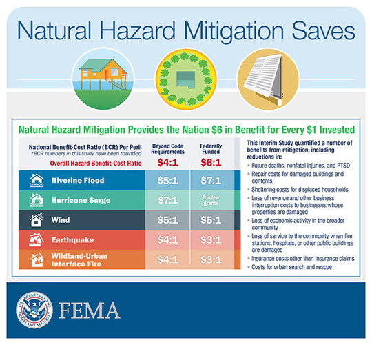
The Natural Hazard Mitigation Saves: 2017 Interim Report was released in the beginning of 2018 by the National Institute of Building Sciences (NIBS) Multi-Hazard Mitigation Council (MMC).
The Institute's project team looked at the results of 23 years of federally funded mitigation grants provided by the Federal Emergency Management Agency (FEMA), U.S. Economic Development Administration (EDA) and U.S. Department of Housing and Urban Development (HUD).
Visit the Natural Hazard Mitigation Saves: 2017 Interim Report web site to see the full report.
|