|
|
Water Talk Newsletter - Fall 2017
October 3, 2017
In This Issue
Water Talk Newsletter is issued three to four times per year.
If you have ideas or requests for the next edition of Water Talk, contact editor Ceil Strauss.
By Pete Boulay, MNDNR State Climatology Office
In mid-August 1988 I
camped with my scout troop on Lac Des Mille Lacs in southern Ontario, Canada. Our
site was at the dam that marks the beginning of the Seine River. In the middle
of the week, thickening nimbostratus clouds promised foul weather. Rain
commenced and did not cease for 48 hours straight. An empty canoe was nearly
full of rainwater. The placid river became a torrent and Canadian workers had
to arrive via helicopter to remove the stop logs from the dam. We estimated it had to be at least a foot of rain, maybe more. Nearly 30 years later I found the closest rain
gage - about 10 miles away in Upsala - had a two-day
total of just 4.84 inches.
120 years earlier, a land
surveyor in western Pope County was equally exposed to the elements. Little
would be known about the July 18, 1867 storm had George B. Wright not
presented his Notes of a Remarkable Storm
before the Minnesota Academy of Natural Science on March 7, 1876. Wright stated that he and his crew “… experienced rainfall perhaps without parallel in
temperate climates.”
 Wright was curious about the extent of the storm and did
his own “bucket survey.” He located “One very intelligent farmer at Westport,
Pope Co” who had a large kerosene cask standing on the prairie away from any
building was from 2/3 to ¾ full. Wright mentioned that the people of Sauk
Center and Osakis claimed with unanimity that rainfall exceeded 30 inches and
probably reached 36 inches. There were few rain gages in action at the time in
the state and one of the closest was at Fort Ripley in Morrison County that saw
7.50 inches of rainfall. At Ft Ripley the Mississippi River rose eight feet
from this storm and caused much damage to log booms and bridges. We may never
know what the actual total was from this storm.
In 1978, The National
Oceanic and Atmospheric Administration published a paper regarding the Probable
Maximum Precipitation (PMP) for areas of the US east of the Rockies and this
included Minnesota. The PMP is defined as “the theoretically greatest depth of
precipitation for a given duration that is physically possible at a certain
time of year.” This is a useful calculation to have for engineers working on
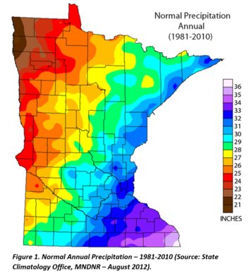
large drainage areas. For Todd County this value is around 29 inches in 24
hours. How close has an event reached the PMP? Hard to say in 1867 whether or
not these would have approximated the PMP for their areas due to the lack of
rain gages. There were just a handful in the state in July 1867.
|
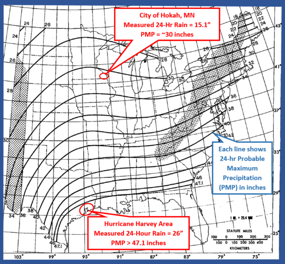 Figure 2. Probable Maximum Precipitation for 24-hour, 10 square mile event. Source: Adapted from NOAA Report No. 51, 1978
By the dawn of the 21st century, there were approximately
1,400 rain gages in use by volunteers in Minnesota, with the bulk of which
though the 90 Soil and Water Conservation Districts. Each of these gages has
the capacity of about eleven inches. About 175 were with the National Weather
Service that used larger gages with the capacity of 23 inches.
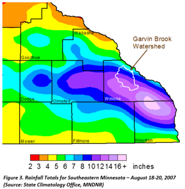
On August 18-20,
2007 the largest measured rainfall
occurred in Minnesota with the volunteer reader one mile south of Hokah in
Houston County reporting 15.10 inches. The elderly gentleman needed help
lifting the 8-inch diameter gage with so much water in it. The largest
non-National Weather Service measurement with a standard 4-inch rain gage with this event was
17.21 inches in 24 hours. The PMP for far south east Minnesota is around 31
inches. The value at Hokah is 49% of the PMP. In comparison, the highest 24
hour total found with Harvey with a National Weather Service gage was 26.03
inches at Port Arthur SE TX AP in Jefferson County. With a PMP in this area of
47.10 inches this was about 55% of the PMP or fairly similar to the percentage
at Hokah. The 24-hour total US record remains 43.0 inches at Alvin, Texas on
July 25 1979 with Hurricane Charlotte.
|
The message here is that
instrumentation matters. If there are no rain gages, quantification of these
events become very difficult. Over the years thousands of unpaid volunteers
across Minnesota and the county peer into a rain gage each morning and
dutifully report the totals. These observers tend to be quite elderly and new
energetic people will need to replace them in the future. Otherwise, we will be
back to looking in empty barrels and buckets and coming up with our best
guesses. True, there are radar-based precipitation estimates and automated
gages, but nothing can replace the quality of a good human observer. A
nationwide volunteer program called CoCoRaHS (Community
Collaborative Rain Hail and Snow Network) is always looking for new observers. If people continue volunteering there will be quantifiable information on
“Remarkable Storms” for years to come.
The National Flood Insurance Program (NFIP) was set to expire September 30, 2017, but was extended by legislation signed on September 8, 2017.
A wide variety of NFIP reforms has been discussed over the last few years, and those discussions are expected to continue.
The extension is part of a congressional continuing resolution (H.R. 601)
raising the debt limit and funding the U.S. government until Dec. 8. It
also authorized a total of $15.25 billion in emergency funding for
disaster relief and rebuilding that includes $7.8 billion for Hurricane
Harvey victims.
See links to more information about NFIP reform and other topics of
interest to floodplain managers at the Association
of State Floodplain Managers (ASFPM) site.
Some people seem to think it is alright to drive through water, or they drove through water before and didn’t have an issue. Some people seem to think their car is a multi-function vehicle and can operate as a boat.
One foot of water can displace 1,500 pounds of weight. That would be enough to float a small car. Two feet of water will carry most vehicles away. Six inches of moving water can sweep a person off of their feet. Water can be deeper than it looks or a road surface under the water could already have been eroded away. The simplest, easiest way to stay safe is to stay out of the water.
Pop Quiz Question: Which picture is a photo of a boat and which one is a truck?
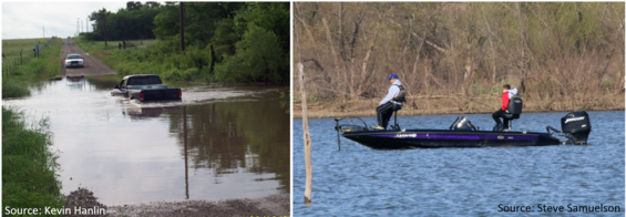 Pop Quiz Answer: Stay out of the water.
Editor's Note: This article is adapted from the Kansas October 2017 Floodplain Tips newsletter, and is reprinted with permission.
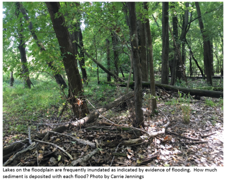
By Carrie
Jennings, PhD, P.G. - Research and Policy Director, Freshwater Society
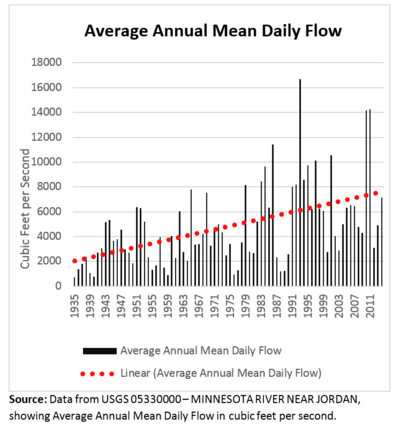 Minnesota River flows are increasing from a combination of
change in climate, ground cover (evapotranspiration) and altered hydrology. Increased
flows mean that rivers have been widening and sediment has been moving throughout
the watershed.
River Filling and Dredging
The Lower Minnesota River, from Carver Rapids to the
confluence with the Mississippi, is a low-gradient, broad reach of the river.
If you wade into the brown water you may be surprised to find that the bottom
is actually sandy. Based on the yearly gaging data, about half an inch of sand
would accumulate in the channel each year if it were not dredged.
We know that this stretch of the river is meant to slowly
fill in, or aggrade over time due to its geologic history, slope and width. However,
the rapidity with which the sand is accumulating is affecting ecosystems and
more immediately, it is inconvenient and costing taxpayers money.
|
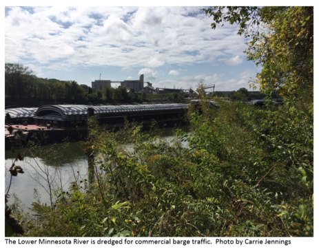 It has the
potential to affect commercial barge traffic to the Port of Savage; is using
more taxpayer dollars as dredging tries to keep up with the river-filling sand;
and will spread sand on a proposed paved bike trail that would run along the
levee from the Bloomington Ferry Bridge to Ft. Snelling that DNR contract
archeologists were evaluating last summer. Why would flood managers care about
this?
|
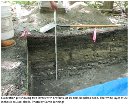 Archaeological
test pits dug along the proposed bike trail route were turning up nothing,
which seemed odd to the team contracted to do the work. They finally did hit a
couple of layers with artifacts near the natural levee of the river buried by
10 and 20 inches of sand. One layer contained a confusing mess of items that
included: a white ceramic pipe stem from Paris that could have dated to the
European contact period, some abraded and some sharp pot sherds, some metal,
and a small triangular piece of blue plastic. That the layer included metal and
plastic means that it dated to the modern time and was redeposited here with
older materials, possibly by a large flood event.
|
If the half inch of sand that is accumulating in the channel
were spread evenly over this part of the river valley, this site could date to
the 1960s and the archaeologists would have to dig another 6 to 10 feet to get
back 200 years, to the European-contact period. So were they only looking at
decades of sediment burying the layers? We don’t know because no one has tried
to measure the post-settlement sediment accumulation rate on this portion of
the floodplain.
|
Study Being Done for Lower Minnesota River Watershed District
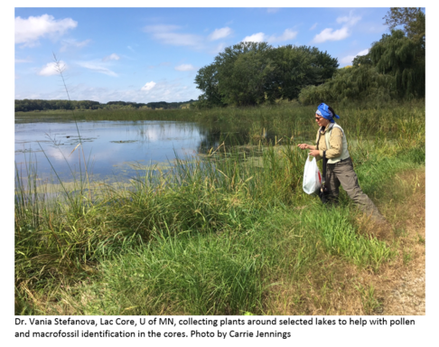
The Lower Minnesota River Watershed
District (LMRWD) has engaged Freshwater Society and Lac Core, U of MN to collect
and study sediment cores from floodplain lakes that are annually flooded by the
Minnesota River and have potential for annual deposition of riverine
sediment. Core analysis will focus on fossil
pollen and non-pollen palynomorphs (stomata, algal cenobia, fungal spores and
charcoal particles) preserved in the lake sediments that can be used to trace the
major landscape changes following the European settlement in the region when
the native hardwood forests or prairies have been converted to agricultural
fields and ragweed, and other weeds. This will lead to an estimate of changes
in accumulation rates of sediment deposited in the overbank setting between
Chaska and the Mississippi River.
|
In the Future
Ultimately, the LMRWD is interested in
facilitating the creation of more upstream water storage to reduce flows and sedimentation,
but recognize that they may require more documentation to demonstrate the
extent of the impact.
Floodplain managers can extrapolate that
with more sediment in the channel and on the floodplain, floodwaters have less
accommodation space resulting in higher and more expansive floods. Sedimentation also reduces the protection
afforded by levees. How much freeboard
we are losing and how quickly is an important management question to answer.
|
The Minnesota Association of Floodplain Managers will hold
its annual conference November 15-16, 2017 at Breezy Point Resort in Pequot
Lakes. The CFM exam will be offered at
the conference site on November 17th. Registration is now open.
See the MnAFPM
web site for more details.
|
|
 |
|
|
|
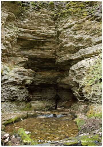
The DNR has been working
closely with the University of Minnesota to make available decades worth of groundwater
tracing information. This information is an important resource for water
planning and management in the karst regions of Minnesota.
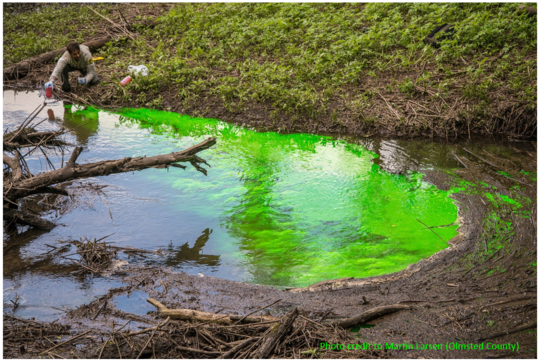
Dye Tracing
Groundwater tracing
using fluorescent dyes has proven to be an effective method for understanding
groundwater flow, travel times and interconnections with surface water. Dye
tracing involves pouring dye into sinkholes or sinking streams and observing if
and where it emerges after flowing through the karst conduit system (usually at
a spring or multiple springs). Results have important implications for the
protection of trout stream resources and other ecosystems in Minnesota and
elsewhere. Additionally, understanding subsurface conduit flow in karst terrain
is central to water protection and management associated with spill response, agriculture,
water demands, and landscape alteration.
Dye Trace Reporting and Geospatial Data
An
expansive list of historic and recent dye trace reports is now available on the
DNR
Dye Tracing webpage. These summarize results mostly from dye trace studies
across the southeastern portion of the state (mostly in Fillmore, Houston, Olmsted,
and Winona counties but also sparsely in Dakota, Dodge, Hennepin, Mower, Pine,
and Wabasha counties). Geospatial data for these traces is currently available
upon request, including dye input points, descriptive information, inferred
groundwater flowpaths, and springshed delineations. The data will eventually be
incorporated into a web map service available for state
and public use. Users will be able to query, select and view the data and
associated reports alongside the Minnesota
Karst Features Database and the Minnesota
Spring Inventory.
|
The Minnesota Groundwater Tracing
Database is an important tool to manage and protect groundwater in Minnesota
and making the data more available will add usability to the expansive
inventory of karst in Minnesota for generations of scientists and policy makers
to come.
Contact
Information
Please visit mndnr.gov/groundwatermapping
for more information about springs, dye tracing, karst and other DNR County
Geologic Atlas Program projects.
Jeff Green, Hydrogeologist, 507-206-2853
John Barry, Hydrogeologist, 651-259-5660
|
|
 |
By Matt Bauman & Jenny
Shillcox, MNDNR Land Use Unit
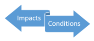
One of the handiest zoning tools a community can use is the
“condition.” As local zoning administrators and decision makers, it is
important to remember that every development proposal in your community has some
sort of an impact – whether it affects views, privacy, shoreland habitat, local
hydrology, or water quality – and that communities have the power to mitigate
(or reduce or offset) those impacts with conditions. Requiring conditions on
permits is common, and every community should be actively using them.
 Development proposals requiring a variance or Conditional
Use Permit require a greater level of scrutiny due to the special problems that
the development may create. These proposals require a public hearing, where potential
impacts can be identified and discussed. If findings support granting the
variance or CUP, the extent and types of impacts should be considered in
developing appropriate conditions to mitigate them. Minnesota law allows
communities to impose conditions when granting a variance as long as the
conditions are directly related and roughly proportional to the impact
created by the variance.
There are some cases where imposing conditions is not a
choice, but a requirement. When the variance involves nonconforming lots of
record in shorelands, Minnesota law states that communities shall require the
property owner to address, when appropriate, storm water runoff management,
reducing impervious surfaces, increasing setbacks, restoration of wetlands,
vegetative buffers, sewage treatment and water supply capabilities, and other
conservation-designed actions.
|

Variance conditions serve to ensure that the intent of the
regulation being deviated from is met, and to mitigate the impact of the
proposed activity. Through thoughtful conditions that can be enforced
long-term, the intent of the regulation can often be achieved.
For all conditions,
it is important to ensure that they are complied with and enforced long-term.
Communities can do this by setting specific timeframes or deadlines for meeting
conditions. Communities may also consider requiring the following to help ensure
compliance with the conditions:
|
-
Financial
sureties to ensure that the required conditions are completed within specified
deadlines,
-
As‐built
drawings and/or photos as proof of completion within the terms of the
conditions, and/or
- Long‐term
maintenance and operation agreements for stormwater best management practices and
vegetation that must be protected or restored as a condition of approval, along
with notices of restrictions recorded against properties to ensure that future
property owners are aware of their responsibilities and don’t unknowingly
“undo” any conditions.
The legal basis for conditions has been tested, clarified
and supported in many high profile legal cases. For example, Nollan v.
California Coastal Commission (1987) made clear that a community must
demonstrate a connection (or “nexus”) between a development and the required
condition being imposed. For example, if there’s setback encroachment, any
conditions attached should focus on the mitigation of that encroachment –
whether that be visual screening or a buffer to capture increased runoff. Dolan
v. City of Tigard (1994) later clarified how much mitigation is too much. The
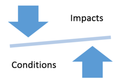
Dolan decision acknowledged that most impacts are difficult to quantify, and
does not have to be shown with mathematical precision. However, the mitigating
condition being imposed must be “roughly proportional” to the impact of the
development.
Almost all developments create at least one impact. This is
a tool communities should be using strategically to benefit their community and
protect the resource.
|
For more information and examples see the DNR
web page on Variances
in Shoreands, Flooodplains & Other DNR Protected Waterways. A good place to start is “The
Basics: What Communities Need to Know” (six pages) from the Shoreland &
Floodplain Variance Guidance Series that was prepared by DNR in collaboration
with the League of Minnesota Cities, Association of Minnesota Counties and the
Minnesota Council on Environmental Advocacy.
Perennial questions about whether the Ordinary High Water (OHW) elevation is a boundary line and who owns the bed of a lake came up at a recent county zoning officials training.
Over 30 years ago, the article Pardon
Me Myth! Who Owns the Lake Bed? addressed those same questions in the the Summer 1987 Water Talk issue. (Editor's note: Author Dave Milles was Supervisor of the Waters Permits Unit of the Land Use Section, DNR Division of Waters, at the time of the original article.)
The following excerpts are from Water
Laws in Minnesota: Questions and Answers about Minnesota Water Laws (last revised 12/2012).
Who owns the bed of a lake, marsh, or watercourse?
When a waterbasin or watercourse is navigable under the federal test, the State of Minnesota owns the bed below the natural ordinary low water level [see Minnesota Statute 84-032; Lamprey v. State, 52 Minn. 1981, 53 N.W. 1139 (1983) and United States v. Holt State Bank, 270 U.S. 49 (1926)]. The federal test used for navigability is “when they are used, or are susceptible of being used, in their natural and ordinary condition, as highways for commerce, over which trade or travel are or may be conducted.” [See State v. Longyear Holding Co., 224 Minn. 451, 29 N.W. 2d 657 (1947).] If a court has found that a lake is non-navigable and meandered, the shoreland owners own the bed of the lake in severalty. [See Schmidt v. Marschel, 211 Minn. 543, 2d 121 (1942).] If a stream is non-navigable but has been meandered, the shoreland owners own to the thread (centerline) of the stream. If a lake or stream is non-navigable and not meandered, ownership of the bed is as indicated on individual property deeds.
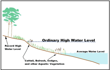 What is the ordinary high water level?
The ordinary high water level is an elevation that marks a regulatory boundary of a Public Water lake, wetland, or stream. It is the highest level at which the water has remained long enough to leave its mark upon the landscape.[See Lake Minnetonka Improvement, 56 Minn. 513, 58 N.W. 295 (1894), and Minnesota Statutes, Section 103G.005, subd. 14.] Generally, for basins, it is the point where the natural vegetation changes from predominantly aquatic to predominantly terrestrial. On streams and rivers, it is the top of the bank of the channel.
|
What is considered trespassing when the public seeks access to a water body?
The
belief that the state owns a strip of land around all Minnesota lakes
for public use is false. Riparian property (property abutting a lake,
river, or wetland) is either privately or publicly owned. The general
public can access water bodies or watercourses via public property, but
not through private property. Individuals entering private property
without permission from the landowner are trespassing and may be
prosecuted under the state trespass laws. A person who has legally
gained access to a water body may use its entire surface for recreation,
such as boating, swimming, or fishing; and any “incidental use” of the
bed or bottom, such as anchoring a boat or decoys, wading to fish or
swim, and poling a boat, is allowed.
The following trainings by DNR staff are scheduled:
-
October 25, 2017 (W), 8:45 am - 4 pm - Grand Rapids (DNR offices); County Selected Special Topics (9-12 Floodplain Management Basics; 1-2:30: Interpreting Floodplain Maps or Using FEMA digital data;
2:45-4 Mitigation Grants or Elevation Certificates)
-
October 26, 2017 (Th), 12:30 pm - 7 pm - Thief River Falls (DNR/DOT offices); County Selected Special Topics (1-2:30: Interpreting Floodplain Maps or Using FEMA digital data; 2:45-3:45 Mitigation Grants or Floodplain Culverts; 4-7: Floodplain Management Basics)
-
October 31, 2017 (T), 8:45 am - 4 pm - Cambridge (MN National Guard Armory); Standard Floodplain & Shoreland Training (9-10:15: Floodplain Basics or Higher Standards; 10-25-11:40: FEMA mapping overview & updates or Shoreland Basics & Special Topics; 12:40-1:30 Accessing web-based maps; 1:45-2:50 Interpreting Floodplain Maps or Variances in Shoreland & Floodplain (Shoreland Heavy); 3-4 Floodplain Administration & Permitting Process or LOMCs & Determining BFEs in A-zones)
-
November 2, 2017 (Th),
8:45 am - 4 pm - Blue Earth County Historic Courthouse (Mankato); Special Topics (topics to be chosen about one month in advance)
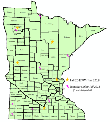
- TBD Winter 2018 - Fergus Falls area
- TBD Spring/Fall 2018 - There will be County Selected Topics trainings as part of the County
Map Modernization effort
at many locations.
 MnDNR will be updating the Floodplain
Training and Education page as we get upcoming trainings confirmed.
Contact Ceil Strauss at
ceil.strauss@state.mn.us or 651-259-5713 for more details on the topics
to be covered at a particular site, or to RSVP for a training.
|
Actual, scheduled and projected dates since Summer 2017 Water Talk:
Preliminary Maps
- Polk County (revised) - by end of 2017 (anticipated)
- Wright County (revised) - by end of 2017 (anticipated)
- Scott County (revised panels) - Q1 2018 (anticipated)
- Fillmore County (revised) - Q1 2018 (anticipated)
- Carver County (revised panels) - Q1 2018 (anticipated)
- Blue Earth County (revised panels) - Spring 2018 (anticipated)
- Nicollet County (revised) - Spring 2018 (anticipated)
Letter of Final Determination (LFD)
- Polk County - Q2 2018 (anticipated)
- Marshall County - Q2 2018 (anticipated)
- Wright County - Q2 2018 (anticipated)
- Houston County - Q2 2018 (anticipated)
- Scott County - Q3 2018 (anticipated)
- Carver County - Q3 2018 (anticipated)
- Fillmore County - Q3 2018 (anticipated)
Effective (6 months after LFD date)
- Crow Wing County - August 15, 2017
- Kittson County - September 29, 2017
See latest timetable
for past and future map updates and more about FEMA
map updates in Minnesota.
|
|
|
On August 29, 2017, FEMA issued a letter clarifying that floodplain
culvert projects are eligible to have Conditional Letter of Map Revision (CLOMR)
and Letter of Map Revision (LOMR) review fees waived. CLOMR
and LOMR submittals are required by FEMA and the state for projects located
in FEMA Special Flood Hazard Areas (SFHAs) that would affect base flood
elevation (BFE) elevations and/or the floodplain or floodway boundary. Fees for CLOMR and LOMR
submittals range between $6,500 and $8,250 per submittal.
This exemption
is valid for floodplain culvert projects using the Geomorphic
Approach to Infrastructure Design at Road/River Intersections. The project must
be a standalone bridge/culvert replacement with minimal other roadwork, or part
of an overall ecological restoration project (e.g., stream restoration) where
adding the floodplain culverts would further enhance the ecological benefits.

The waiver was granted under Section 22 of the Homeowner Flood Insurance Affordability Act of 2014 (HFIAA), which
states that the “requester
shall be exempt from submitting a review or processing fee for a request for a
flood insurance rate map change based on a habitat restoration project that is
funded in whole or in part with Federal or State funds, including dam removal,
culvert redesign or installation, or the installation of fish passage.” For the
purpose of this exemption, “habitat restoration” will have the same meaning as the
term is defined in the Partners for Fish and Wildlife Act, 16 USC 3772 (5).
To have the fee exemption applied on a specific project, the requester
must specify how the project meets one or more of the following:
1.
Placing
floodplain culverts will improve the passage of terrestrial organisms by
allowing them to pass under roadways, thus enhancing biological connectivity.
2. They will enhance stream stability allowing for
more diverse biological communities to colonize and propagate, thus retaining
longitudinal connection for aquatic organisms.
3. Floodplain culverts will protect the aquatic
ecosystem of rivers and riverine wetlands by maintaining the water quality as a
result of sediment reduction. They will
allow for a more diverse aquatic community to thrive including the intolerant
species that are considered valuable indicators of water quality.
For more information
Visit Geomorphic
Approach to Infrastructure Design at Road/River Intersections website to
learn more about floodplain culverts, as well as floodplain and channel
connectivity.
If you have questions, contact:
Kevin Zytkovicz, River
Ecology Unit, 651-259-5151
Salam Murtada, Land Use
Section, 651-259-5688
|
|
|
|