Delivering a watershed's ecological story
A mapping
application created by DNR staff helps deliver the story of the ecological health of Minnesota’s
watersheds.
The app pulls together “layers” of information that helps DNR staff spot trends across the landscape, which leads to better informed environmental
actions.
The web-based mapping and exploration tool uses a five-component framework to
help people visualize how a wide range of natural conditions and land use
changes affect a watershed’s ability to deliver clean water and other
environmental benefits.
The idea is,
if users can better see a
wide range of ecological trends, that might encourage land use choices
that consider the impact
to the overall health of the system rather than focusing on just one outcome,
said Beth Knudsen, DNR project manager for the Watershed Health Assessment
Framework and research analyst.
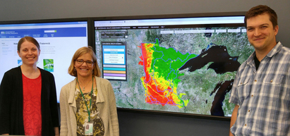
(Her team is pictured in the photo, from left, Kitty
Hurley, MNIT application developer, Knudsen, and Ben Gosack, watershed assessment data and technical lead.)
The tool
relies on a powerful, custom GIS mapping application to deliver more than 30
health index scores that compare conditions across Minnesota on a 0-100 scale,
red to green color ramp. The scores combine multiple layers of data organized
around five components of watershed health – biology, connectivity,
geomorphology, hydrology and water quality.
So, for instance, a biologist may be looking for management actions
that would prevent farm runoff from impacting a sensitive fish community in a
stream. “We’re hoping
that the assessment framework helps you look at stream biology together with
the other four components, to think about whether you may be having an
unintended consequence by your action,” Knudsen said.
|
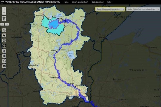
Image from watershed health assessment framework map application
of different watershed scales for Leech Lake. Leech Lake catchment (pink
outline); upstream contributing area (light blue fill), major watershed (black
outline), downstream catchments (dark blue fill), inside a gray mask of the
major river basin. To view this same image on your computer, click here. Want to keep
exploring? Click the set location tool and
click another spot in Minnesota to view nested watersheds for that
location.
Users can select any
point of interest on the map and display the surrounding catchment (the
smallest watershed unit the DNR has mapped), major watershed, and basin, or
outline upstream and downstream areas.
The
publically available app helps DNR staff share and collaborate with local land
managers at townships, counties and others working on watershed plans. Anyone
could create a map and then simply send a link to someone else who can open up
the map and zoom in and out and change scale.
Users can
see watershed boundaries, what’s upstream and downstream and how it all
connects to a bigger system, like the Mississippi River. Going far beyond
simply displaying boundaries, the interactive map lets users explore land use
and think about activities next door, over the horizon and far away.
“I find it
difficult to walk through a report about a watershed and cookie cutter maps,”
Knudsen said. “You have a cut out boundary but cannot see over the boundary.
You have no idea what’s going on next door. We put that watershed into a
statewide context and put that watershed back into a broader spatial boundary.”
The health
scores expose where there’s an intensity of conditions like loss of vegetation,
stream alterations and loss of stream connectivity. With a couple of clicks,
related GIS data displays to help explain the pattern of red to green
watersheds.
Birds-eye
tour of the Yellow Medicine River watershed: DNR staff used this tool to provide a virtual flying tour of the watershed
at a meeting with participants working on a watershed plan. A birds-eye view,
moving upstream and downstream along the river and its tributaries, helped the
group visualize some of the driving forces that influence water quality and ecological health in the
watershed.
Annette
Drewes, a DNR clean water specialist who works with watershed teams in
northwestern Minnesota, said it’s easy and quick to pull up information,
particularly color maps to share. “People can understand it pretty quickly.”
The app provides
a way for Drewes to quickly become familiar with a particular watershed. She
can look for altered hydrology, land cover, impaired waters, and pull those
layers into the map while identifying state parks, scientific and natural areas,
state forests along with other federal and public lands.
“It’s a great tool to
get a quick overview of many of these resources and the data that is available
about the watershed,” she said. The interactive maps can be viewed and shared
anywhere with an internet connection making it a valuable tool for working with
local partners.
The Legacy funded project has received appropriations
from the Clean Water Fund and during the last few years a dedicated staff has
helped enhance its functionality.
For more tips on using app, check out the Instructional
Materials.
Want to hear more about managing
for watershed health? Subscribe
to the WHAF newsletter for quarterly updates and stories from the watershed framework team.
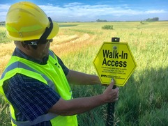
Hunters have access to more private lands this year
|
For the past three weeks, a DNR crew has been posting
boundary signs on 40 new Walk-In Access areas across 46 counties. The WIA program provides public access to
private land and pays landowners for providing that access. Beginning Sept. 1, 26,700 WIA acres will be
available to hunters. That's up from 23,400 acres last year.
|
|
 |
'Big Bog' recognized with national wetlands award
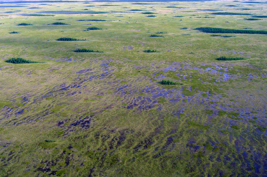
The Red Lake Peatlands, a vast wetland complex in
northern Minnesota, also known as the “Big Bog,” was recently designated by the
Society of Wetland Scientists as a “Wetland of Distinction.”
Peggy Booth, supervisor of the DNR’s
Scientific and Natural Areas Program nominated the peatlands for consideration
under the new Wetlands of Distinction initiative, aimed at
advancing public education and awareness of the values of wetlands.
The core area of the Red Lake Peatlands is
protected as a scientific and natural area and by the Big Bog State Recreation
Area. These areas are among the highest
quality examples of patterned peatlands in the country.
“The Red Lake Peatlands are a
world-class ecological treasure and it’s great news they’re gaining the
attention and recognition they deserve," said DNR wetlands program coordinator Doug Norris. "They are in many respects equivalent
to the Florida Everglades.”
The Red Lake Peatlands were among the first group of
20 wetlands nationwide to receive the Wetlands of Distinction designation. The SWS specifically recognized the peatlands
for the following exemplary ecosystem services:
-
Maintaining ecological connectivity and cohesion.
-
Recreation (birdwatching and ecotourism).
-
Carbon storage.
The well-deserved selection of the Red Lake Peatlands as a
Wetland of Distinction will enhance international recognition for this
outstanding component of Minnesota’s diverse wetland landscape.
For more
information on Wetlands of Distinction and on the Red Lake Peatlands, see the
initiative’s website at www.wetlandsofdistinction.org/.
Just do it! Annual Employee Right to Know training due soon
The annual
Employee Right to Know training needs to be completed by Dec. 31.
You can sign in to Employee Self-Service to enroll and take the
required training. New employees are expected to take the training
within their first 60 days. Supervisors should identify what courses they
expect staff to undertake.
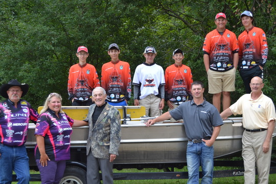
The Grand Rapids High School fishing team and their coaches
visited the Grand Rapids regional headquarters this week for a tour with
Commissioner Landwehr. The team toured the hatchery, discussed fisheries
management and career opportunities with area fisheries supervisor, Dave
Weitzel, and boarded a DNR fisheries field boat for a photo with Bob
Lessard.
Letters from Minnesota
This note came from John Guy, an angler on the Mississippi River. His letter refers to conservation officers Jacob Willis and
Vuthy Pril.
Good evening Commissioner Landwehr:
I am writing you regarding a license check and safety
equipment check Friday afternoon on the Mississippi River upstream of Lock No. 1
near downtown Minneapolis. The two DNR conservation officers were professional and
courteous. After completing their check we talked fly fishing (they were interested
as they had not tried fly fishing).
This is not my first interaction with DNR officers. I've been checked various
times over the 16 years I've lived in Minnesota. I'm sharing this with you because I am an avid
fisherman and follow the outdoor news and know you all seem to garner more than
your fair share of criticism.
I want you to know about Friday's encounter with your
officers and how well they represented your department.
I grew up on St. Andrews Bay in Panama City, Florida, and moved to
South Carolina after college to start my career so I've been fortunate to
experience those amazing fisheries. We moved here 16 years ago and I think
Minnesota offers the most diverse and exciting fishery I've ever seen. I've
fished all over the U.S. and parts of Canada and none can hold a candle to Minnesota.
Deep water trolling on Superior, stream trout fishing in the southeast part of the
state, walleyes and my current favorite - fly fishing for smallies on the
Mississippi and St. Croix, we are fortunate here in Minnesota.
Best wishes for your continued success and please give my
regards to your two officers.
John Guy
From the field...
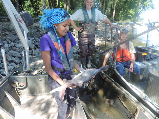
DNR fisheries biologists are continuing their long-term
effort to tag and track paddlefish in the Mississippi and St. Croix rivers to
monitor populations of these and other species of fish. Early this week they
were on the Mississippi in Hastings. Fish and Wildlife summer intern Gebriela Ayana got a
chance to see fisheries work up close – and even hold a paddlefish! She is pictured (left to right) with Lake City fisheries biologist Doug Dieterman and Lake City fisheries research scientist John Hoxmeier.
Commissioner awards
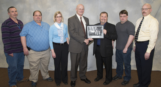
Operational excellence -- team award
Uninterruptible Power
Supply Replacement Project Team
The team was tasked with immediately
replacing the uninterruptible power supply at the DNR Central Office with
minimal disruptions to the essential operations and delivery of public services. Summer storms required staff to be present all night to protect vital
information systems. The project required almost perfect synchronization of
numerous subtasks to prepare for the system’s replacement. The project was
completed faster than expected and under budget with minimal disruption to the
department. Pictured, left to right; Stan Gruska, John Meemken, Liz Parent, Tom Landwehr, Dan Parent
(team leader), Stuart Cremeen, Jay Oster. Not pictured: Sally Dybdal, Marcia Honold.
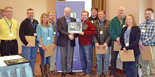
Operational excellence -- team award
Saint Louis County Strategic Land Asset Management Team
This team developed a county-wide land
asset management plan for DNR and county-administered lands in Saint Louis
County, which will be the largest state and county land exchange project to
date. The partnership improved the efficiency of land management, reduced
boundary lines to manage, and benefited stakeholders and citizens by allowing
both the DNR and the county to be more effective in managing public resources.
Pictured left to right: David Dahl, David Weitzel, Sherry Watson, John Voges, Tom Landwehr, Joe Rokala (team leader), Daniel Prazak, Chris Balzer, Mark Rudningen, Andrea Johnson, Darrel Schindler. Not pictured: Robert Slater,
Katherine Giel and Katherine Rossman.
Outdoor recreation -- individual award
Rebecca Oestreich has worked on improving
accessibility at the DNR’s interpretive wayside exhibits. She assisted with four
Request for Proposal processes for Itasca, Gooseberry, Blue Mounds and Minneopa
and with text and sign layout throughout the Parks and Trails Division. Her
efforts will allow individuals with varying abilities to enjoy their outdoor
recreation experience.
|
Outdoor recreation -- individual award
Ed Quinn is a leader who provides excellent customer
service to his internal and external customers while displaying departmental
values such as the culture of respect and culture of safety. In cooperation
with other Parks and Trails staff, Ed was recently able to obtain two LCCMR
large grants: reintroducing/interpreting bison ($600,000) and restoring habitat
and providing education related to Monarch butterflies and other native
pollinators ($672,000).
NOTE: A new commissioner award exhibit is now on display on the first
floor of the Central Office. Award posters are
available on the I-drive at I:\ALL\Commissioner Awards Photos. (Select the
August-September Exhibit PDF).
Accessibility Training Courses in 2017
All of our electronic content must be accessible to all individuals. Training will provide you with the necessary tools and knowledge to make content accessible from the start. Plus, it will help you meet the Minnesota Statute for Accessibility and DNR Operational Order 132 directives. Enrollment is now open for several free electronic information accessibility (EIA) courses. Find a course that works with your schedule on the EIA training page.
|