Seats are
still available for two courses conducted by FEMA at the beautiful Emergency Management Institute’s (EMI) Emmitsburg, MD campus:
ADVANCED FLOODPLAIN MANAGEMENT CONCEPTS II course (E282) - August 3rd - 6th, 2015
ADVANCED FLOODPLAIN MANAGEMENT CONCEPTS III course (E284) - August 24th - 27th, 2015
This
course is pre-approved for 12 Core Continuing Education Credits (CECs) for
CFMs. If you are a state or local government employee you may attend the
training for FREE with all
expenses covered except meals (meal tickets are approximately $120 for the week). Travel cost reimbursement for
state and local government employees is detailed in the Welcome Package. Please share this opportunity with
others who may have an interest in attending the course.
COURSE
DESCRIPTIONS
The
advanced courses are very interactive and provide an opportunity to share your hard
earned knowledge and benefit from the experience of your peers.
The
E282 course August 3rd - 6th, 2015 covers the
following four topics:
Higher Standards in Floodplain Management (1 day).
Placement of Manufactured Homes and Recreational Vehicles in the Floodplain (1 day).
NFIP Flood Insurance Principles for the Floodplain Manager (1 day).
Hydrology and Hydraulics for the FPM (1day).
The
E284 course August 24th – 27th, 2015 covers the following five topics:
Floodway Standards (1 day).
Disconnects between NFIP Regulations and Insurance (1 day).
Common Noncompliance Issues (½ day).
Digital Flood Insurance Rate Maps (DFIRMs) (½ day).
Editor's note: I was lucky enough to attend a course at EMI last year and highly recommend it -- the faculty keep things lively and interesting, the campus is lovely, and the surrounding countryside is picturesque! And you get to meet your counterparts from all over the country and learn about their issues. Definitely worth applying, now or in the future -- Suzanne Rhees
Historic buildings on the EMI campus
Upcoming Minnesota Training Offerings
1. July 27-30, 2015 – FEMA’s G273 course,
“Managing Floodplain Development Through the NFIP” -Save the Dates (Details being finalized).
Class runs July 27-30 and the CFM exam offered 7/31/15.
Location: Minneapolis Public Works, 1200 Currie Ave N, Minneapolis 55403
Course content: This is the field deployed version of the E273 course that is offered at FEMA’s EMI training site in Maryland.
Target Audience: Local officials responsible for administering local floodplain management ordinances, including but not limited to floodplain management administrators, building inspectors, code enforcement/zoning officers, planners, city/county managers, attorneys, engineers, and public works officials. This also includes state and regional floodplain managers (including watershed districts). The course is designed for those officials with limited floodplain management experience.
2. August & September 2015 - One Day Floodplain
(and some Shoreland) Trainings for Local Officials & Others (i.e.,
surveyors, consulting planners/engineers, lenders, realtors)
Topics to be presented in 2 concurrent tracks: Floodplain
management basics (history/definitions/floodway vs flood fringe uses); Shoreland
management basics; Zoning and permit process/record keeping basics; FEMA map
interpretation; FEMA map updates; flood insurance basics (including highlights
of 2012 & 2014 Reform Acts); FEMA map appeals/revisions; determining BFEs
in A zones, etc.
Tentative locations (dates for many locations
being finalized - watch for updates):
August 12, 2015 – Grand Rapids (DNR Office, 1201 East Highway 2)
September 3, 2015 – Apple Valley (Dakota County Western Service Center, 14955 Galaxie Ave.)
Metro area (at least 1 more – location & date TBD)
Mankato – date TBD
Moorhead – date TBD
Rochester – date TBD
Roseau (tentative) – date TBD
Windom – date TBD
Others?
To
register for the above trainings, contact Ceil Strauss @ ceil.strauss@state.mn.us or
651-259-5713
Managing Nonconforming Lots in Shoreland
Why is it important to manage nonconforming lots in shoreland areas?
The small, nonconforming lots that predate shoreland management may
have been suitable for small, seasonal cabins for which they were initially
intended.However, they are not suitable
for current lakeshore uses or development trends. It is difficult for these small
lots to meet the 25% impervious surface limit in state shoreland standards
provide space for a backup septic system, and provide enough vegetation to
filter and treat stormwater. Development of small lots increases the risk of
nutrient flow into surface waters and degraded water quality. Small lots also
increase the risk of drainage problems between lots and harm to near shore
habitat from docks placed too close together.
Changes in statute may affect local ordinances
Regulating the development and sale of nonconforming lots in shorelands can be complicated. Nonconforming shorelandlots must be managed in conformance with state statute, which supersedes some standards in the 1989 shoreland rules and potentially in some county and city ordinances. In 2009, the Legislature made two changes to statute affecting the sale and development of nonconforming lots in shorelands.[1] These changes were made to insure that the sale and development of shoreland is consistently administered across the state.
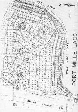
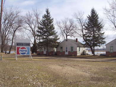
Typical small lakeshore lots that predate shoreland zoning.
The changes affect:
When variances are not needed for single nonconforming lots of record;
When contiguous lots under common ownership must
be combined.
When variances are not needed for single nonconforming
lots of record
The revised statute allows single nonconforming lots of
record to be allowed as building sites without
a variance from lot size requirements (the minimum lot size requirements in
state rule unless the local standard is stricter) when:
all structure & septic system setbacks are met;
a type 1 sewage
treatment system can be installed or a connection can be made to a public
sewer; and
impervious surface
does not exceed 25%.
If all of these conditions cannot be met, then a variance is
required and the local government processes that variance according to its variance
procedures and statutory criteria. The statute does not require that these
three criteria be met to approve a variance, though minimizing deviations from
these standards is a good idea. The statute simply provides local governments with
an expedited manner for approving the development of nonconforming shoreland
lots of record. (Of course, local governments may be stricter and require a
variance for developing nonconforming lots, even if they do meet the three
criteria.) These statutory provisions supersede relevant parts of Minnesota
Rules 6120.3300 Subp. 2D.
When contiguous lots under common ownership must be
combined
Statute allows owners of most contiguous nonconforming
shoreland lots to sell and develop them according to local regulations. Statute
only affects the treatment of the smallest nonconforming lots. According to statute,
an individual nonconforming lot that is part of a contiguous group of lots
under common ownership must be
considered a separate parcel for sale or development,
if:
the lot is at least 66% of lot area and width requirements in state rule (6120.3300 Subp. 2a);
the lot is connected to a public sewer or a Type 1 sewage system;
the impervious surface does not exceed 25%; and
the development is consistent with the comprehensive plan.
If the lot does not meet all of these criteria,
then the statute states that the lot MUST be combined with one or more of
the contiguous lots so they equal a conforming lot as much as possible. Because
the statute is mandatory, local governments cannot grant a variance to this
statute[2].
However, the statutes include an “out” for the sale of certain lots. Contiguous lots under common ownership that don’t meet the above four criteria may be sold (but not developed), if they contained a habitable residential dwelling at the time they came under common ownership, and:
the lots are suitable for, or served by, a sewage system consistent with MR 7080, or
they are connected to a public sewer.
The statutes apply regardless of the subdivision processused to create the lots or when the lots were created.The statutory provisions supersede relevant parts of 6120.3300 Subp. 2D.
Application to Wild & Scenic River and the Lower St. Croix
Riverway districts
While the statutes refer to “shoreland” lots of record, the DNR
interprets these statutes as applying to substandard lots in the Wild &
Scenic River and the Lower St. Croix Riverway districts.
Summary
In general, Minnesota law affords a great deal of protection
for the continuance, repair, replacement restoration, maintenance and
improvement of legal nonconformities.Given these broad protections, it is notable that the law specifically
limits these protections for small shoreland lots by stating when nonconforming
shoreland lots must be combined. This is a clear signal that the Legislature's
intent was to eliminate small nonconforming lots in certain situations. Local
governments should review their ordinances for compliance with current Minnesota Law
governing nonconforming lots in shoreland areas.
[1]
The same changes were made to MS 394.36 (for counties) and MS 462.357 (for
cities).
[2]Local governments cannot grant variances to mandatory statutes.Although Minnesota Statute (Section 394.27, Subd. 7 for counties and Section 462.357 Subd. 6 for cities) permits local governments to grant variances, the authority extends only to variances from “official controls” or “zoning ordinances.” Officialcontrols and zoning ordinances are defined as actions taken by local governments that are adopted by ordinance. Neither statute authorizes local governments to grant variances to a mandatory statutory requirement.
FEMA Map Updates
New Maps Going Effective:
Mahnomen County – April 2, 2015
Wilkin County – May
18, 2015
Letters of Final Determination (Letters sent 6 months before effective dates):
Norman County – March 30, 2015
Kandiyohi County – March 30, 2015
Anoka County – June 2015 (anticipated)
Hennepin County – August 2015 (anticipated)
Kittson County – September 2015 (anticipated)
Scott County – November 2015 (anticipated)
Polk County – November 2015 (anticipated)
Olmsted County – March 2016 (anticipated)
90-Day Appeal Periods:
Scott County – 1/29 to 4/29/2015
Polk County – 3/11 to 6/8/2015
Olmsted County (2nd) – June to September 2015 (anticipated)
Roseau County (2nd) – June to September 2015 (anticipated)
Crow Wing County – June to September 2015 (anticipated)
Marshall County – June to September 2015 (anticipated)
Wright County – July to October 2015 (anticipated)
Carver County – July to October 2015 (anticipated)
Open Houses/Resilience Meetings:
Fillmore County – April 8, 2015
Houston County – April 9, 2015
Crow Wing County – July 2015 (anticipated)
New Preliminary Maps:
Houston
County – 12/31/2014
Yellow Medicine County (revised) – June 2015 (anticipated)
Fillmore County (revised) – June 2015 (anticipated)
Chippewa County – August 2015 (anticipated)
Winona County – September 2015 (anticipated)
NOTE: Anticipated dates likely to be pushed back as issues arise
Risk MAP Spring 2015 Update
FEMA’s national
Risk Mapping, Assessment, and Planning (Risk MAP) program is intended to result
in local activities that reduce risk.In
2014, in partnership with the state of Minnesota, FEMA Region V initiated activities
designed to engage selected communities in discussions about local risk
reduction activities that result in safer communities. Since then, FEMA
Region V and the state have been facilitating meetings with community officials,
mitigation consultants and regional stakeholders to define desired local
mitigation activity implementation steps, challenges and needed technical
support. This effort is not intended to replace existing mitigation
planning efforts, but to enhance them by identifying federal and state tools,
resources and technical assistance that may enable progress on local risk
reducing mitigation activities.The meeting
goals include development of a local implementation strategy for a community selected
mitigation activity, and in some cases, limited technical support toward
progress on that activity.
In Minnesota, FEMA
and the Minnesota Department of Natural Resources and Department of Public
Safety have been working with STARR, FEMA’s consultant, to discuss mitigation
actions with Minnesota communities.Through this partnership, mitigation technical assistance needs have
been documented for future funding consideration and to inform local planning
efforts.In addition, some communities
are receiving technical assistance or other support to reduce risk including
coordination with the Community Rating System program and improving ordinances
to include higher standards based on better data.
In the spring of
2015, the program is wrapping up efforts to connect with communities about
their local mitigation needs with some last meetings in the St. Louis River watershed.Some communities, such as Edina, Montevideo,
Granite Falls, Olmsted County, St. Louis Park, and Worthington, continue to
receive technical assistance to support their risk reduction efforts. Going
forward, FEMA and the state of Minnesota will be considering additional
technical assistance support and other efforts to help communities take action
to reduce flood risk.
If you have any
questions about the program, please contact any of the following project
partners:
Every ten years communities of more than 1,000 people must
submit a water supply plan to the Minnesota Department of Natural Resources
(DNR).This requirement, in place since
the 1990s, is designed to encourage communities to deal proactively with
providing sustainable drinking water for citizens, businesses, and industry.[1]These plan updates will be due between 2016
and 2018; the DNR will be notifying communities as to when their specific city
water plan is due.
Communities are asked to describe their existing and planned
water supply, and to develop an emergency plan and a conservation plan.In the new update there will be greater
emphasis on demand reduction and developing rate structures that encourage
conservation.All communities in the
seven-county metropolitan area, even those of fewer than 1,000 people, must
also fill out an additional section relating to the Metropolitan Council’s Master
Water Supply Plan.
The DNR and Metropolitan Council have been working together to
update the template to make it quicker and easier for communities to complete. Templates
will be available this summer. There are
no major changes from the last template, but the format will include more
checkboxes and suggestions for water conservation.
“Many areas of Minnesota are blessed with abundant water,”
said Carmelita Nelson, DNR water conservation consultant.“However, groundwater water resources are not
limitless and in some areas we are hitting the limits.We are seeing more instances where withdrawal
is impacting sensitive natural areas or interfering with other wells or
affecting drinking water quality.”
Approximately 75% of Minnesotans depend on groundwater for
their drinking water.The remaining 25%
obtain their drinking water from surface water.“In the last ten years, groundwater specialists have learned a great
deal about aquifers, and we are collectively going through an evolution in the
way we look at appropriation and sustainability,” said Steve Thompson, DNR
hydrogeologist. “In the past, we have made decisions on well permit requests
individually.In the future, we will
need to start looking at water appropriation requests cumulatively, using
modeling to insure that wells are sustainable.”
“In next ten years, conserving our drinking water sources
will become more and more critical,” added Nelson. “We will need to do more
water reuse and conservation. We may likely need to start prioritizing uses for
deeper aquifers and for shallower wells.”
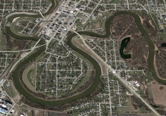
This Google Earth image clearly shows Crookston's levee system and adjacent open space along the Red Lake River.
In November
2014, following years of effort on several fronts, a Letter of Map Revision
(LOMR) requested by the city of Crookston, Minnesota, became effective.The LOMR reflects the additional flood protection
created by the city’s renewed levee system, and removes the Federal flood
insurance purchase requirement for hundreds of properties.[1]While the completion of a LOMR is not mitigation
in and of itself, the efforts of the community to get to that point demonstrate
a great deal of commitment by the city’s citizens and elected officials.
Mitigation
in a community can be a slow-moving activity, often taking years of effort by
residents and community officials. In
Crookston, 18 years of persistence and dedication have paid off in making the
city more flood resilient.The historic
flooding of 1997 broke most existing flooding records in Crookston.This flood was preceded by a long series of
similar flood events, in 1950, 1965, 1966, 1969 and several subsequent years. [2]After six weeks of flooding and sandbagging,
the city of Crookston knew that it was time to begin a new strategy to live
with its river.
To begin
the effort, the city created a special service district that would collect a fee
with the express purpose of providing a fund for various flood reduction
activities and projects.After 20 years in place, Crookston’s flood
fee district is required to be dissolved during the 2017 tax year.
In
recent years the fee has generated funds of about $300,000 per year[3].
While the monies were originally envisioned as a way to fund the construction
of levees for the city, due to a modification in state flood control policy,
the Minnesota DNR took over the funding of local flood control. Therefore, the
funds[4]
have instead been utilized to support the maintenance of the city’s levees and for
property buy-outs.[5]
The fee
structure is based on a scale of risk, with undeveloped properties with the
least risk assessed $50 per year and then increasing by steps, based on risk
and exposure, up to $300 for those properties removed from what would be in the mapped flood zone
without the benefit of a flood control structure.
A
condition of the creation of the flood tax area requires Crookston’s city
council to conduct an annual public hearing to allow citizen comment on the
district and to determine if the district should be reauthorized for another 12
months.It is worth noting that at the
Council meeting in June 2014, after 17 years in place, no objections from
residents were recorded.
Crookston
is not alone in taking charge of its flooding problem by putting some ‘skin’ in
the game through the use of a local tax on residents.Both Austin and Moorhead are also using dedicated
funding to pay for flood mitigation.In
Austin, a one-half-percent sales tax approved in 2006 is projected to raise
approximately $14 million for mitigation projects over its 20-year life.[6]And in Moorhead the city created a property
assessment system based on the benefit afforded to those properties covered by
new flood control projects.[7]
FEMA estimates
that each dollar spent on mitigation will save four dollars in response costs over
the long term.And mitigation extends
well beyond the placement or hardening of structures:creating special taxing districts, restoring
wetlands, conducting buy-outs, elevating structures, maintaining effective and
comprehensive floodplain regulations, joining FEMA’s Community Rating System,
and many other strategies all have a place in mitigating the negative effects
of flooding on human infrastructure.
Mitigation
is a process, and the result of a community’s mitigation goals and efforts can
take years or even decades to realize.Crookston’s
willingness to tax themselves stands as a great example of how a community can
show their commitment to addressing their flood risk and become a more flood
resilient place to live, work, and thrive.
[1]
Letter of Map Revision Case No. 13-05-7394P. Federal Emergency Management
Agency. Published November 14, 2014.
[7]
Tom Trowbridge, City of Moorhead Assistant City Engineer, and Amy Weigel, City
of Moorhead Special Assessment Coordinator.Personal communications, March 12, 2015.
What’s the CRS & Why Would My Community Want to Join?
There are two
main reasons to consider joining the Community Rating System (CRS):
1. A higher level of floodplain management that leads to reduced flood damage risk (to lives, property, and economic activity) in your community, and
2. Save money on flood insurance premiums for landowners/citizens with structures in the higher risk areas.
The National Flood Insurance Program’s (NFIP) Community
Rating System (CRS) is a voluntary incentive program that recognizes and
encourages community floodplain management activities that exceed the minimum
NFIP requirements. As a result, flood insurance premium rates are discounted to
reflect the reduced flood risk.
Communities get points for activities such as: public
education/outreach, providing FEMA map information, higher regulatory standards,
additional flood data, flood data maintenance, open space preservation,
stormwater management, flood damage reduction and preparedness.Communities can choose from the smorgasbord
of activity options; the one required activity is using the FEMA Elevation
Certificate.
The more points a community earns, the greater the discount
for flood insurance on policies within the community. CRS community ratings range
from the highest possible rating of “Class 1” to a “Class 10” community that is
not in the program and does not get any discounts.A Class 8 community gets a 10% discount in
Special Flood Hazard Areas (SFHAs) and a 5% discount in non-SFHAs*.In Minnesota, the communities with the
highest CRS rating are Class 5, meaning a 25% SFHA and 10% non-SFHA discount.
These are usually communities that have done extensive flood damage reduction
projects and preserved significant open space.
With the 2012 and 2014 updates to federal law, the cost of
flood insurance is rising significantly for many classes of structures in the
high flood risk zones.This is
especially true for the older pre-Flood Insurance Rate Map (pre-FIRM)
structures that have had subsidized premiums, but are being phased to premiums
based on their actual elevations.Communities
with many flood insurance policies in their SFHAs are encouraged to consider
the CRS program.
Is it
difficult to qualify for the CRS?
In most cases – No!If a
community administers the state model ordinance they often have enough
points to be a Class 8 or Class 9 community.The
best way to start the process is to do a bit of background reading, and then
contact the ISO/CRS contact serving Minnesota, Melissa Mitchell (see contact information below). Melissa can also provide a community-specific “What If” document
that shows the policy count and potential CRS discount amounts, which can be
very helpful for a community considering CRS to see.
Announcing the new ISO/CRS Contact for Minnesota: Melissa
Mitchell - 913-543-0632,mitchell@iso.net
(Melissa is
based in Kansas and will also work with communities in Kansas, Missouri,
Nebraska, Iowa and Arkansas.)
You can also contact Minnesota State Floodplain Manager Ceil
Strauss at 651-259-5713 or ceil.strauss@state.mn.us
if you need help determining how many flood insurance policies there are in
your community or finding out more about the CRS program.
*Preferred Risk Policies (PRPs) already are discounted and
do not get additional CRS discounts.
Latest FEMA Mapping Site Updates
FEMA updated their main map access sites in mid-May
2015.Following are changes of
particular interest:
1.
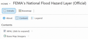
New Interactive Map
Icon - If you search for a specific address, city or county in a Digital Flood
Insurance Rate Map (DFIRM) county, there is now an “Interactive Map” link (in
addition to the “View Map” and “Save Map” links).This “Interactive Map” icon links to the FEMA
National Flood Hazard Layer (NFHL) Viewer site, which shows the flood zones
with many background options, access to Letters of Map Amendments, etc.The MSC site previously had a link to the
Viewer available, but it was in a format that was easily overlooked.
2.Browsers Can Be Finicky – the icons shown above
may not line up nicely, or the site may not work properly.If you have these problems, try a different
browser, or check with your IT advisors to see if you can adjust your settings (e.g.,
security settings).
1.
More viewing options
- There is more flexibility to turn layers on and off, see some layers in
different formats (e.g., spatially or in a table), and to change the
transparency of the layers.Click on the
“Content” icon for options.
2.Default view changed - In the previous default
view, Letters of Map Amendments (LOMAs) and Letters of Map Revision based on
Fill (LOMR-Fs) showed up as purple dots with case numbers noted (once zoomed in
enough).Now the default view does not
include LOMAs, LOMR-Fs or Letters of Map Revisions (LOMRs) unless you go to the
content options and turn on those layers.
See Basics on These Sites in Past Water
Talk Articles
Stay in the Loop - Keep Contact Information Current
The Water Talk newsletter is published electronically 2-4 times a year, focusing on topics and resources related to floodplain management, shoreland management, and other DNR land use programs: Wild & Scenic Rivers, and the Mississippi River Corridor Critical Area.
Our main target audience is local officials involved with floodplain and shoreland management or mapping, as well as those at the watershed district, regional, state & federal level. Other target audiences include: surveyors, engineers, lenders, insurance agents, realtors, and others involved with properties or projects in floodplain and shoreland. If you did not receive this link directly, you can subscribe at: http://www.dnr.state.mn.us/waters/watermgmt_section/floodplain/index.html
Help us to keep our local official contact list current.If you are the city or county contact for zoning / permits, or the engineering contact, or the emergency manager, and you did not receive the link to this newsletter directly, please forward your contact information and role to ceil.strauss@state.mn.us
Please let us know what you think of the content and format of this newsletter, which will continue to evolve based on your feedback. Contact Ceil Strauss (see above) with comments or questions.