Summer 2014 Vol. 27 No. 3
In this Edition:
Climate change is forcing State government to break-down the various silos which have been built up over decades. It's why last
fall Governor LePage created the Environmental and Energy Resources Working Group
to ensure our approaches as government agencies were cohesive, consistent and
helpful, and that the various agencies did not send conflicting requirements,
data or inconsistent information. The group is led by DEP and is comprised of:
DMR, DACF, DOT, Energy and IFW.
We
want to hear your suggestions, recommendations and ideas on how we as agencies
can reduce any impediments we have created, unblock road blocks we may have
built and learn how we can undertake a cross-agency approach to climate change
adaptation work you need to accomplish. Adaptation work is going to take all of
us working together, and your voices will help us build a shared understanding
of the need for the 21st century of environmental regulation. One that is
focused on innovation, collaboration and expertise.
We held three listening sessions in Portland, Bangor and Houlton and are still accepting comments. Please submit them to Erle Townsend by Friday, June 20. Your suggestions and recommendations can help move our economy and our environment forward.
By Stephenie MacLagan, Shoreland Zoning
 Did
you know that there are mapping tools available, even for municipalities
without GIS software?
The
Maine Stream Habitat Viewer could be called the “culvert viewer.” This mapping
tool shows culverts, roads, natural resources and habitats such as Atlantic
salmon and trout streams. Clicking on a feature brings up the description of
the habitat or condition of the culvert. This can be a handy tool not just for
development planning but also for planning climate change adaptability projects. Which
culverts are priorities for replacement due to flooding and/or habitat
obstruction? The Stream Viewer is just one of many online mapping tools hosted
by the Maine Office of GIS.
More recently, the University of Maine Sustainability Solutions Initiative released an online mapping tool called Maine Futures Community Mapper. This planning tool can help municipalities identify land areas suitable for certain uses or conservation, and visualize potential future development under different scenarios, in the Lower Androscoggin and Casco Bay watershed and the Lower Penobscot River watershed. Layers like water bodies, roads, conserved lands and land cover types can be viewed in any Maine community.
Another new tool is available for Washington County municipalities, the Public Parcel Viewer and Planners Maps. With the ability to search by address, the Public Parcel Viewer includes tax map information, with links to the registry of deeds. It also depicts the shoreland zoning, if known, and wetlands and conserved lands. Additionally, the Planners Maps depict information to assist with planning activities, including development infrastructure, brownfield sites and shellfish habitat. These maps will continue to be updated and further developed under a partnership between the Washington County Council of Governments and the University of Maine at Machias.
Don’t
forget, many DEP and MEGIS layers are available for viewing through Google
Earth. At these websites, you can will be prompted to download Google Earth if it is not already on your computer.
If there are planning or enforcement tools you find helpful, send
suggestions for future article topics to Stephenie.
|
By Mike Morse, Shoreland Zoning
 In the last several editions of the Shoreland
Zoning News, we discussed nonconforming structure relocation provisions. Today
we are introducing the new nonconforming structure expansion provisions enacted
by the Maine Legislature and contained within our proposed rulemaking to amend
Chapter 1000.
For years expansion has been limited to less
than 30% of the floor area and volume of the structure, or for some
municipalities the alternative expansion provisions regulated combined total
floor area and height limitations based on the distance of the structure from
the shoreline. For the most part, the new language combines these two expansion
provisions into one new set of standards.
Under the new standards, a nonconforming
structure may be expanded up to 30% of the footprint of the structure or up to
a certain established limit (based on setback from the shoreline), whichever is
greater. All portions of the structure are considered “footprint,” including
decks and patios. Structure height is also limited, much as it was with the
previous alternative expansion provisions, except that the new language allows
the structure height to be either the established height limit or the height of
the existing structure, whichever is greater.
While this is not a formal evaluation, you may
be interested to know that of the phone conversations we’ve had with folks
about the new provisions, it seems that roughly half of the people will be able
to expand more, and the other half not as much as the current rule allows. It
was not our intent to be more or less restrictive. Rather, the intent was to
create a simpler, cleaner set of standards.
Suffice it to say, the new language provides
additional flexibility for some landowners, but it no longer requires seemingly
onerous volume calculations in any case. Municipalities should have a far
easier time reviewing and tracking expansions. Municipalities must amend their
ordinances, and have them approved by DEP, in order for these new provisions to
be effective locally. Please contact us for guidance on amendment language, or
wait for the amendments to Chapter 1000.
What did you think about the story series on
nonconforming structures? Have ideas for the next story series? Please let us
know!
|
The Department posted a working draft of amendments to Chapter
1000 in May. We received a number of comments and questions on that draft, and staff is reviewing those now. A revised draft will be posted for public comment this summer.
The goal of this rulemaking is to incorporate legislative changes to the Shoreland Zoning Act into Chapter 1000,
and to make other clarifications that have been identified by staff and
stakeholders through experience with the existing rules. If you have questions, contact us.
By Stephenie MacLagan, Shoreland Zoning
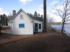
 Q: Are structures that are built on moored docks or floats regulated by shoreland zoning?
A: Since
these structures are either “extending or located below” the shoreline, they
are subject to the shoreland zoning standards (only where municipalities have
extended applicability of the ordinance to structures below the shoreline).
Because
of inconsistent phrasing in Chapter 1000, we consulted with the Attorney
General’s Office. We determined that the standards apply to all structures and
uses extending or located below the shoreline. A moored dock/float (and
anything on it) does not have to extend from the shoreline, by way of rope or
dock systems, in order
to be subject to local shoreland zoning.
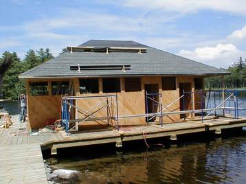
This
makes sense given the purposes of shoreland zoning and the standards that aim
to protect the surrounding character and uses of the area. The standards for
these structures:
- favor
temporary over permanent structures,
- prohibit
new structures that are not functionally water-dependent, and
- prohibit
changing the use of existing structures to dwelling units.
The
reason for these standards originated from the fact that waters of the state
are held for use by the public, for recreation and fishing. Small, temporary
docks for boat access or swimming don’t unreasonably interfere with this public
use. Such structures are in line with the iconic character of shorelines along
Maine’s great ponds and other waters.
Conversely,
permanent structures and large, temporary structures can interfere with public
use of state waters and prevent shoreland zoning purposes from being achieved.
State leases or easements would be required for such structures located over
submerged lands, but cannot be granted for structures that:
- are
not water-dependent,
- require
shoreline access across private property,
- potentially
create a risk to public safety, and/or
- potentially
create a hazard to navigation.
|
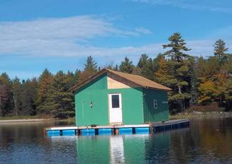 Hopefully, you haven’t seen, and won’t see, structures like this, but feel free to contact us for assistance if your local ordinance regulates structures extending or located below the shoreline.
These seemingly outrageous stories come from municipal officials like you, so please continue to suggest article topics to Stephenie.
|
Use the 2013 highest annual tide table
Annually, with
assistance from the Maine Geological Society, the Department has produced an
elevation table identifying the highest annual tide (HAT) or maximum spring
tide line. Currently, we’re working on a different method; in the meantime,
continue using the 2013 HAT Table.
Maine Geological
Survey staff is working diligently to produce a table of elevations derived
from an alternate method, which would cause the elevation data to be applicable
for a longer period of time, rather than for a single year. Additionally, the
new method will result in greater consistency. These elevations are used
primarily by surveyors for the purposes of delineating the upland edge of a
coastal wetland.
Upcoming trainings
Looking for shoreland zoning credits or just want to learn something new?
Striking a Balance:
Marine Water Quality. June 26 in Ellsworth. Registration required by June 23. Good for 3 shoreland
zoning credit hours. Sponsor: Hancock County Planning Commission.
Annual Soil Erosion Control Field Day. July 10 in Richmond. Registration required. Good for 5 shoreland
zoning credit hours. Sponsor: Maine Rural Water Association.
Soils and Natural Resource
Workshop. September 3 in Weld. Registration required by August 25. Good
for 6 shoreland zoning credit hours. Sponsors: MAPSS/MAWS/MASE/SSSNNE.
Watershed Survey
Workshop. September 12 in Auburn. More information. Sponsor: Volunteer Lake
Monitoring Program.
Erosion and Sedimentation Control Workshops. This fall, statewide. Sponsors/hosts wanted, please contact Bill.
|