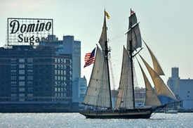
 A Message from the Director
Time flies when you're having fun and planning for a growing Baltimore. Which is exactly what 2014 felt like at the Department of Planning. The City of Baltimore is experiencing a new development boom as we continue to recover from the 2008 recession. New housing units are up by nearly 10,000 units since 2010, with another 3,200 units under construction and several hundred more under review. Construction cranes are once again visible throughout the City, as new and long-term development projects have gotten underway.
This special edition of the Compass is a 2014 Year in Review, an opportunity for each division within the Planning Department to share some of their accomplishments and celebrate the successes of the past year. It's been a busy year for us, with the launch of our INSPIRE planning process in conjunction with the 21st Century Schools Initiative, our South Baltimore Gateway Master Plan development for neighborhoods around the new Horseshoe Casino, CHAP's 50th Anniversary celebration, and the list goes on!
Finally, I'd like to wish you, your colleagues and families a healthy and prosperous 2015. We are looking forward to another year of growth and development, and pledge to continue to work on making Baltimore the most vibrant City it can be, now and in the future.
Sincerely,
Thomas J. Stosur, Director
|
COMMISSION ON HISTORIC AND
ARCHITECTURAL PRESERVATION (CHAP)
The Division of Historical and Architectural
Preservation serves as the staff for the City of Baltimore Commission for
Historical and Architectural Preservation (CHAP), which has helped to preserve
and revitalize our City's historic neighborhoods and sites since 1964. The CHAP
mission is to enhance and promote the culture and economy of Baltimore through
the preservation of buildings, structures, sites and neighborhoods that have
aesthetic, historic and architectural value. CHAP goals include preserving
historic architecture and monuments; promoting neighborhood revitalization;
preventing demolition by neglect; and integrating our City's past into its
future.
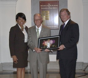 Above: Mayor Stephanie Rawlings-Blake and Commission Chair
Tom Liebel honor Tom Ward, the City Councilman who in 1964 introduced
legislation to create the Commission for Historical and Architectural
Preservation.
It has been a year of
change and celebration for the Commission and staff. 2014 marked the 50th anniversary
for the Commission for Historical and Architectural Preservation. This
Anniversary was celebrated with the opening of an exhibit that chronicled
CHAP’s history on October 28, 2014. At this opening, current and former staff,
Commissioners, and supporters came together to both reminisce and look to the
future, as the Mayor handed out gifts to life-long preservationists. Also in
2014, Executive Director Kathleen G. Kotarba retired from more than 35 years of
service. Her efforts helped secured Baltimore as one of the most historic
cities in the country. In September, Eric Holcomb, who has worked for CHAP
since 1994, became the Executive Director following a nation-wide search.
Strengthening
Baltimore’s Communities
Most notably among CHAP's accomplishments, historic district permit activity
climbed in 2014 to 717 Notice-to-Proceed permits issued within 33 locally
designated historic districts and 194 historic landmarks. This is the highest
number of permits issued annually since CHAP was established.
In addition, the
Commission approved a variety of major new projects, including:
- The rehabilitation and an addition to the Raffel building in South Baltimore,
- A new
single-family home in the historic mill village of Dickeyville in West
Baltimore,
- The restoration of the Florence Crittenton Home – an historic
mansion – with the construction of 19 adjacent townhomes in Hampden,
- A three-story vertical addition on a 1930s garage building in Mount
Vernon, and
- The restoration and an addition on Recreation Pier
in Fells Point.
This year, the Commission reviewed more than 50 items in public
hearings. As important, CHAP revised
its guidelines to address Lead-based
Paint hazards in historic buildings, ensuring that buildings and neighborhoods
can be both historic and safe.
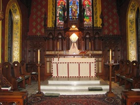
Above: The interior of St. John's in the Village.
New
Historic Designations
In 2014, CHAP approved the National Register
designations of the Berea-Biddle and McDonogh Street neighborhoods. In
addition, eight
new Baltimore City Landmarks and one Public Interior Landmark were designated
by Mayor and City Council, including:
- Parkway Theatre,
- Monumental Lodge #3
IBPOEW,
- Enoch Pratt House,
- Public School 103,
- Rehoboth Church of God in
Christ Jesus Apostolic, and
- the exterior and public interior of St. John’s in
the Village.
This brings the city-wide Landmark total to 189 exterior and 3
public interior landmarks. The designation of the City Hall Rotunda as a Public Interior is also currently underway for 2015.
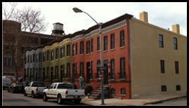 Above: A row of formerly vacant rowhouses are now occupied homes in the
growing Station North arts district.
Increasing
Investment through the Historic Restorations and Rehabilitation Tax Credit
 In 2014, the Historic Tax Credit
brought an incredible amount of investment to the City’s Historic buildings and
neighborhoods. As of 2014, the program has generated over $722 million dollars
in direct investment in Historic properties with a total participation of over
3,500 substantial projects. There are currently over 1,000 restorations valued
at approximately $600 million underway throughout the City’s historic
districts.
|
This is significant; a 2009 study
published in The Abell Report found
that every $1 of historic preservation tax credits issued by the State of
Maryland leverages an additional $8.53 worth of economic activity in the state. Using this multiplier for the Baltimore City Historic Tax Credit, the $722 million of investment through the tax
credit program thus far will have leveraged more than $6.1 billion worth of
additional economic activity. In 2014 alone, CHAP staff approved 440 new
applications and 306 final certifications, for a total investment of
nearly $110 million in 2014.
On top of the significant investment in
2014, the Historic Tax Credit program had two major milestones. First, in
January 2014, the Historic Tax Credit Legislation was renewed by the Baltimore
City Council, allowing the program to accept applications through February
2016. In October 2014, the tax credit application process moved online. Thanks
to hard work from the City’s Department of Finance and input from CHAP,
applicants can now apply and track their applications online, as well as
receive preliminary approval and final certification letters by email.
Conserving “The Monumental City” through
its Outdoor Sculptures and Memorials
In
2014, the Commission’s staff administered 22 monument restoration and
conservation projects across the city. This year, in honor of the Bicentennial
of the Battle of Baltimore in 1814, the Key Monument and Star-Spangled Banner
monument were restored. These were the final two of Baltimore’s “Star-Spangled
Banner” monuments to be substantially restored – the other three were restored
over the past two years. In 2014, the fourteen bronze statues in Mount Vernon
received conservation treatments, along with six other monuments in city parks
and neighborhoods.
 Above: Reenactors conducted cannon demonstrations in front of
the Star Spangled Banner monument in Patterson Park as part of the Bicentennial
events.
SUSTAINABILITY & ENVIRONMENTAL PLANNING
The
Division of Sustainability and Environmental Planning is the home of Baltimore’s
Office of Sustainability, which staffs the Commission on Sustainability. The Division is also home to Baltimore’s Food
Policy Initiative. The Sustainability
Office and Commission are in the forefront of promoting the City’s Green agenda. Here’s a review of some of their notable 2014
accomplishments.
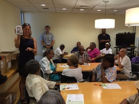
Make a Plan, Build a Kit, Help Each Other
The Baltimore Office of
Sustainability launched the “Make a Plan. Build a Kit. Help Each Other”
campaign on Earth Day in 2014. The campaign focuses on reducing residents’
vulnerability to the impacts of natural hazards by getting residents more
prepared. The first step is working with residents to fill out an emergency
preparedness plan, with information that will be helpful in the event of an
emergency. Residents then work with City staff to build their own emergency
kits. Materials for the kits are provided such as a hand-crank radio, first aid
kit, flashlight, water bladder, sanitary hand wipes, and much more.
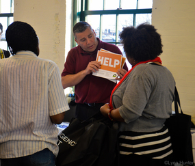 City employees also work with residents to identify ways to increase the ability of
the community to respond together and help each other in the event of an
emergency. Residents share information, identify neighbors who may be in need
of additional care and assistance, determine evacuation routes, and work together
to create response plans for their neighborhood.
The City of Baltimore also
provides residents with “Help/Safe” cards to put in their windows for backup
communication in the event of a power loss and communication systems outage.
To date, the City has distributed over 800 kits and developed over 750
emergency plans with residents.
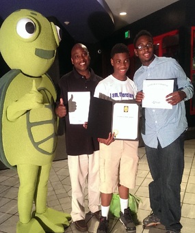
Meet Turtle!
Turtle is the
Baltimore Office of Sustainability’s messenger. Turtle helps make Baltimore a
more Sustainable and Resilient City by encouraging residents to take action.
Turtle provides residents and businesses with tips for their homes, work,
travel and lifestyle that can help save money and make Baltimore a better City.
Turtle likes to attend the JFX farmers market on Sundays; bikes to work on Bike
to Work Day; ensures that people are drinking enough water and staying in the
shade on Code Red days; and attends City events such as Greenscape and the
Growing Green Initiative launch.
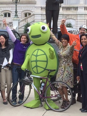 Turtle can be found online on Facebook and Instagram.
Floodplain Planning
On April 2, 2014 the City of Baltimore adopted two bills,
City Council Bill #14-208 and #14-209, that keep the City in compliance with
the National Flood Insurance Program (NFIP) and set the stage for the City’s
application to the NFIP’s Community Rating System (CRS), a flood insurance
discount program that reduces the cost of flood insurance for structures at a
higher risk for flooding. The intention of the Floodplain Map and Code update
was for the City to:
-
Adopt the new FEMA flood maps.
-
Approve
establishment of a new flood zone in the tidal and non-tidal floodplains that
allows the City to regulate floodplain development to the extent of the 0.2%
flood (500-year) citywide and regulate to the height of the 0.2% flood in the
tidal floodplain.
-
Adopt a two-foot
free board citywide in an effort to align with Governor Martin O’Malley’s Executive
Order 01.01.2012.29, Climate Change and “Coast Smart” Construction, enacted in
December, 2012.
-
Incorporate ASCE
24-05/Flood Resistant Design and Construction.
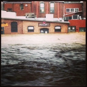
All of the changes to the City’s code are intended to make
Baltimore a more resilient city. The changes accomplished two recommendations
of the City’s Disaster Preparedness Project and Plan (DP3) and will help the
City get closer to becoming a Community Rating System (CRS) community.
Maryland Green
Schools
Education & Awareness Goal #1 of the Baltimore
Sustainability Plan is to “Turn every school in Baltimore into a green school.”
We use the Maryland Green Schools (MDGS) program as our standard for judging
success in this area. The MDGS program is a rigorous process that requires
schools to document integration of the environment into instruction,
professional development, student-driven sustainability practices, community
partnerships, and more. Schools must re-certify every four years to maintain
the designation. Certification with MDGS has been correlated with a
significant, measureable increase in test scores across all grade levels. The
focus of the program is on creating a school-wide culture shift and engaging
students in hands-on environmental learning.
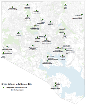
The Baltimore Office of Sustainability works closely with
City Schools that are seeking MDGS certification. The support offered includes
walking them through the process, providing grants tailored to meet the
requirements of the program, connecting schools to partners, and reviewing
applications in advance. 2014 was a banner year, with five Baltimore City
public schools successfully certifying for the first time and another five
successfully recertifying. Baltimore City Public Schools now have more Maryland
Green Schools than ever before, with a total of 22. For comparison, in 2009,
before the City of Baltimore began promoting this program, only 10 Baltimore
City schools were certified Maryland Green Schools. We are now working with
nearly a dozen new schools that have expressed interest, and expect another big
bump in the number of green schools in 2015.
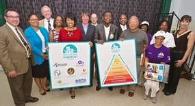
Baltimore Energy Initiative
On September 3, 2014, Mayor Stephanie Rawlings-Blake announced
the Baltimore Energy Initiative (BEI) - a multi-agency, city-wide program to
expand and streamline the City's energy conservation programs, education and
outreach efforts. Funded by a $52 million grant from the Maryland Public
Service Commission’s Customer Investment Fund, BEI will support a number of
existing City programs—supplementing the Mayor's efforts to grow a sustainable
city by reducing Baltimore City's energy use, while promoting local investment.
The Office of Sustainability’s Baltimore Energy Challenge is one of the
programs supported by the new funding. The Baltimore Energy Challenge has
expanded to offer in-home installation services, greater education and outreach
opportunities, as well as a cool roof program. To schedule a FREE in-home
installation of energy saving items call 443-869-2614 or visit www.baltimoreenergychallenge.org.
Growing Green
Initiative
In
May of 2014, Mayor Stephanie Rawlings-Blake
joined the Planning Department’s Office of Sustainability to officially launch
the Growing Green Initiative. The Growing Green Initiative (GGi) is a City-led
effort to use sustainable, innovative, and cost-effective practices for
stabilizing and holding land for redevelopment, and reusing vacant land to
green neighborhoods, reduce stormwater runoff, grow food, and create community
spaces that mitigate the negative impacts of vacant properties – and set the
stage for a growing Baltimore.
 As part
of the Growing Green Initiative, the Green Pattern Book was released and the
Growing Green Design Competition showcased innovative concepts for retrofitting vacant lots in Baltimore
City and turning community challenges into community resources. In
September, seven winners were chosen to implement their designs, and were
awarded close to $300,000, thanks to contributions from the Department of
Planning, Department of Public Works, the Chesapeake Bay Trust, and the U.S.
Environmental Protection Agency.

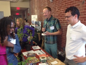
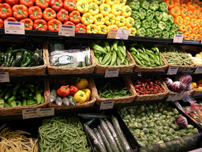
BALTIMORE FOOD POLICY INITIATIVE
To achieve its goal of increasing access to healthy, affordable
food in Baltimore City, the Baltimore Food Policy Initiative (BFPI) is
currently implementing the 10 Food Policy Task Force recommendations and the
newly established Food Desert Retail Strategy, overcoming food policy barriers,
and building stakeholder capacity to expand food access in Baltimore City. A
few highlights from BFPI’s work during 2014 are below.
Food Environment Map
Building off the 2012 Food Environment Map, Planning
and BFPI, with Johns Hopkins Center for a Livable Future updated the
methodology and used enhanced data to create a new food environment map. The
map, along with an extensive report exploring the issues surrounding food
deserts and possible solutions, will be released in spring 2015.
Food Desert
Retail Strategy
The Food Desert Retail Strategy was updated to include four key
components: 1) Expanding retail supermarkets, 2) Improving the food environment
of non-traditional retail, 3) Improving healthy food availability in the Public
Market setting, and 4) Expanding Homegrown Baltimore to serve food desert neighborhoods.
Work is ongoing in all of these areas and will continue to expand and gain
momentum in 2015.
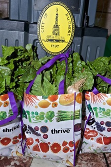
Homegrown Baltimore Workplace
Wellness CSA
The Community Supported Agriculture (CSA) model connects consumers directly to
farmers for a weekly share of produce. In 2014, The City launched a CSA program
open to all employees. Nearly 150 Baltimore City employees participated and
received a seasonally rotating share of fresh produce right in their offices. Some
employees were also able to use their wellness reimbursement to help pay for
the CSA, making Baltimore the first city in the country to underwrite the cost
of a CSA for wellness purposes.
Get Fresh Kids
Having
successfully helped introduce healthy meals into the public markets, BFPI
developed kids’ menus with 9 vendors at Lexington Market. These child-sized
portions come with a healthy beverage and side of fruit, and are aligned with
child nutrition standards. Additionally, BFPI held Kids Food Art Workshops to
teach nutrition lessons to kids and parents and familiarize them with fruits
and vegetables while making edible artwork.

National Food Day
Food Day takes place on October 24 each year, and in 2014 Baltimore
City used a grassroots social media strategy to engage organizations and
residents on food issues. Mayor Stephanie Rawlings-Blake and 195 Baltimore
citizens, posted photos on Facebook, Twitter and Instagram displaying the words
“Healthy affordable food is a basic right using #B’MoreFoodJust. In total, those
posts reached over 520,000 people!

Opportunity Collaborative
The Research and Strategic Planning division
represents the City in a number of regional planning initiatives, including the
Opportunity Collaborative. In 2014, Planning continued to play a key role in
the ongoing work of the Collaborative, a 25 member
consortium charged with developing Baltimore’s Regional Plan for Sustainable
Development (RPSD). Over the course of the last year, the Collaborative developed plans
and strategies for our region’s housing, transportation and workforce
development systems, with a focus on reducing regional disparities. For
additional information please visit the Opportunity Collaborative
website.
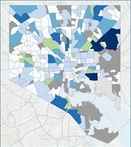
Housing Market Typology
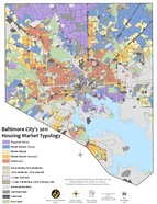 The
Housing Market Typology is developed by the Planning Department, in
partnership with the Department of Housing and Community Development
(HCD), and The Reinvestment Fund. It is updated every three years to
assist the City in its efforts to strategically match available public
resources to neighborhood housing market conditions.
|
The typology is a critical tool used by the Department of Housing’s Vacants to Value program to address city-wide vacant housing challenges. The typology is also used by the Housing Code Enforcement Division to tailor market interventions and strategies to neighborhood conditions.
A newly updated Housing Market Typology will be released in February and will be the feature article in an upcoming edition of the Compass... so stay tuned! Info regarding the housing market typology is available here, including the 2011 map (pictured above).
|
Our Mission...
To
provide the highest level of service and leadership in urban and
strategic planning, historical and architectural preservation, zoning,
design, development, and capital budgeting, to promote the sustained
economic, social, and community development of the City of Baltimore.
TransForm Baltimore
In 2014, the Planning Department participated in the City Council's review of TransForm Baltimore, through a series of public workshops to discuss the detailed recommendations within City Council Bill 12-0152, TransForm
Baltimore The Zoning Code Rewrite. A new zoning code has not been adopted in the City of Baltimore since 1971, and an update of the code will help expedite modern development and private investment. This will ultimately result in the ongoing revitalization of the City of Baltimore, and its 242 neighborhoods.
The legislation, introduced in 2012, completed Planning Commission Review and a series of City Council hearings in the Fall 2013, with very few issues of contention brought to light by citizens, businesses, or property owners.
TransForm Baltimore is an important policy tool for continuing our progress toward a growing Baltimore, complete with stronger neighborhoods and a growing economy. We are hopeful that by continuing our work with the Baltimore City Council, TransForm Baltimore will be finalized, and adopted in 2015.
LAND USE AND URBAN DESIGN
The Land Use and Urban Design Division is responsible for
development project management from small infill projects to large multi-phase
redevelopments. The Division is also critical in helping developers establish
the needed approval process and timeline for development review.
The Division
is responsible for reviewing and making recommendations on all subdivision
proposals, coordinating the inter-agency Site Plan Review Committee (SPRC) and
the Urban Design and Architectural Review Panel (UDARP), reviewing building
permits and making recommendations to the Board of Municipal and Zoning Appeals
(BMZA) on all conditional uses and conversions of buildings. In addition to the development related functions,
the Division also creates and reviews policy recommendations for the City of
Baltimore.
Over the past several years Baltimore’s economy has been
improving as indicated by an increase in development activities. Based on the projects that went to
SPRC in 2014, we estimate that upon full project build-out 3,812 new
residential units and 578,217 additional square feet (SF) of commercial, industrial and retail space will be created in
the City.
As
the economy in Baltimore continues to strengthen, the Land Use Division is in the midst
of reviewing many exciting new projects and embarking on policy changes in 2015 that promise to be equally transformative for the City in years to come. In 2015
the Division is planning to continue its policy work by updating the City’s
Subdivision Regulations.
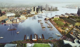
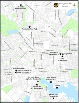 As you can see on the development map above, this is an exciting
time in the City for developments. There many major projects that are being
planned, have approvals or are under construction in the City.
Below is a
snapshot of some of the projects reviewed in 2014 that will greatly enhance the neighborhoods in
which they reside and push development in the City to a new level. These major projects are dispersed throughout
the City and include high rise and urban infill, residential, mixed use, and
commercial.
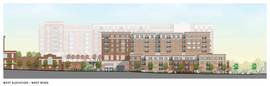
Project Highlights: Neighborhood Infill
Remington Row
PUD
The Remington Row Planned Unit Development was
established in December of 2014 and is a multi-phased, mixed-use development
spanning three blocks in the Remington neighborhood. The development combines new construction and
adaptive reuse to provide new residences, retail, offices and open space along
Remington Avenue.
Phase I of the project comprises a new
five-story mixed use building with a historic industrial aesthetic that has approximately
15,000 SF of ground-floor retail, 35,000 SF of office space on the
second-floor, and 108 apartment units – 105 units on floors 3 – 5th and 3 loft
units at grade. Phase II and III
incorporate the adaptive reuse of two existing buildings for retail and office
use. The landscape plan creates “outdoor
rooms” that will enliven the street, encourage social interaction, and create a
unique sense of place.
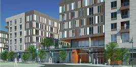
900-920 East Fort Avenue
This
project, located on the northeast corner of Lawrence St and Fort Ave,
consists of ground level retail, six floors of residential, above 2 ½ levels of structured parking, all organized
around two landscaped courtyard spaces. The scheme embraces
the two streets with dominant architectural features at all of
its prominent corners. Unique framing elements and materials highlight the architectural style of the building.
New East Baltimore Community (EBDI)
The
New East Baltimore Community is continuing to take shape. In 2014 the Department approved several new
projects in the area, including a new 170,000 SF office/lab building at 1812 Ashland Ave, an exciting
new six-acre linear park along Wolfe St between Ashland Ave and
Biddle St, and rehabilitated rowhomes along the 1000 block of McDonough.
These projects will continue to add new vitality to east Baltimore by
creating new offices, housing opportunities and park spaces.
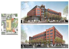
 Poppleton - Center/West
The
first phase of the Center/West project consists of three individual development lots. 101 North Schroeder St will be developed
with 171 dwelling units, 15,186 SF of retail and restaurant uses in a
211,624 SF building.
201 North Schroeder St will be developed with 86 dwelling units,
3,948 SF of retail and restaurant uses in a 101,675 SF building. The southeastern corner of the
block will become a new public park, directly across the street from the Poe
House. A total of 163 parking spaces
will also be provided within this area.
The playful architecture was designed to add a dynamic
element to this west Baltimore community.
The colored panels reflect the diversity of the residences on the
interior elevations that break away from a contemporary expression of the street edge facades.
Project Highlights: Downtown and Inner Harbor
611 S. Charles St. – Banner Hill
The Banner Hill project proposes a six story, 351 unit residential
multi-family project on S. Charles St. between Lee St.and the
Hill St. pedestrian-way near Christ Lutheran Church. The property sits
partially over an existing parking garage serving the church and the adjacent
senior housing facility, and backs on a shared open space and plaza.
 The
Charles Street site, sharing two city blocks, was formerly occupied by a
specialist hospital and its 1986 Lee Street addition. The original conceptual design approach was
to divide the long site into two separate façade expressions, served by two
internal courtyards and a single shared entry/auto court in the northern
section. Different brick colors and
textures will help divide the large building mass into a scale appropriate for Charles
St, while also connecting a more traditional neighborhood
context with the diversity of the inner harbor.
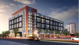
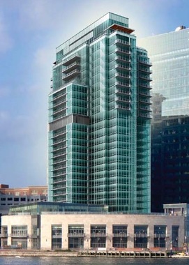
414 Light Street Residential Development
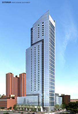
The 414 Light St. project will be located on the northeast
corner of Conway Street and S. Light St., and is proposed to include a 44-story mixed use
tower with approximately 382 luxury apartments and amenity spaces, 12,500 SF of ground floor retail facing Light St., and six stories of parking with approximately 460 spaces.
Inspired by the form of a sail or wave, the
goal of the design is to create an active pedestrian-oriented environment
and promote a better pedestrian connection between the
waterfront and existing communities, while having a positive architectural impact
on Baltimore’s waterfront skyline.
Four Seasons Condominiums
The
Four Season's project will add approximately 64 new condominium units to the top of the Four
Seasons in Harbor East, within the three existing top floors
of the building and eight newly constructed levels.
The current building is 20 stories and the new addition will now reach 28 levels
(with an option to build to 30 levels based on future market demand).
Now Under Construction:
Cranes in the sky mean projects are under construction, and below are
some highlighted projects, approved in 2013, that are currently under
construction.
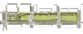
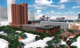
The Rotunda
The Rotunda's 383 residential units and 84,000 SF of retail are
beginning to take shape in north Baltimore.
The framework of the main structures is nearing completion, as the
development begins to create the new 12,000 SF central
plaza.
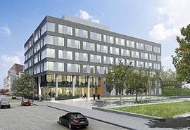
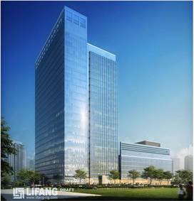
Harbor Point – Exelon HQ Building
The Harbor Point peninsula has been undergoing construction to prepare the site and foundations for the
Exelon Building headquarters. The 647,000 SF building will soon
take shape and begin transforming the former Allied Chemical Site, and begin to frame a
new park plaza. The mixed use project
will also contain the first residential component of the Harbor Point Development.
 Greektown Townhouses
Since 2010 this Planned Unit Development (PUD) has
been well underway. The burgeoning
neighborhood has proved popular and the Phase II townhomes, approved in
2013, are being constructed block by block.
Policy Development
Curb Cut Policies
In 2014, staff also spearheaded revision of the City’s Curb Cut
Policy. Through the years, as public
parking pressures in some neighborhoods has increased the desire to maximize
the use of private property to meet parking needs, causing an uptick in curb cut
applications. In order to bring better balance with protecting pedestrian
movement and safety, the policy was revised to prohibit the use of public
rights-of-way for any structure related to the curb cut application.
COMPREHENSIVE
PLANNING
The Comprehensive Planning division
manages community planning efforts, urban renewal plans and coordination of
plan implementation. Working closely with citizens, neighborhood organizations,
community based non-profits and other City agencies, the Comprehensive Planning
Division helps provide the City with realistic plans that can be successfully
implemented. The Comprehensive Planning Division also manages the development
of the City’s Capital Improvement Program, which targets infrastructure dollars
in support of our community and economic development goals.
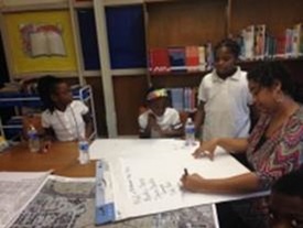
INSPIRE Planning
Through the 21st Century Schools
Initiative, Baltimore City Public Schools, in partnership with the Maryland
Stadium Authority, Baltimore City, and the State of Maryland, will be investing
approximately one billion dollars to renovate or replace schools over the next
several years. The Department of Planning is conducting a planning program for
the neighborhoods around each of the new or renovated schools. The program is
called INSPIRE, which stands for Investing in Neighborhoods and Schools
to Promote Improvement, Revitalization, and Excellence.
The INSPIRE plans will focus on the
quarter-mile surrounding each school to leverage the investment in the school
and enhance the connection between the school and the neighborhood. Plans will
articulate the community’s vision for guiding private investment as well as
identify specific, implementable public improvements in areas such as
transportation, housing, and open space to improve the surrounding neighborhood
so that it can better support the school.
In 2014, the Planning Department held
INSPIRE workshops at three schools: John Eager Howard, Ft. Worthington, and
Lyndhurst. For maps and summaries of these workshops, and information
about additional workshops, click here.
South Baltimore Gateway Master Plan
The South Baltimore Gateway Master Plan is meant to serve as a policy
guideline for the City’s future investments of Local Impact Aid in the
neighborhoods surrounding the Horseshoe Casino in South Baltimore. It
establishes the vision for the entire area comprised of 18 very diverse
neighborhoods. The plan includes recommendations to:
- Increase and improve
transportation connections, access and mobility,
- Improve roadway network and
transit infrastructure,
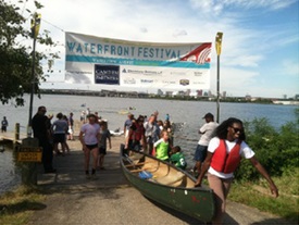
- Improve the Middle Branch shoreline and water quality,
- Expand recreational trail networks,
- Improve public safety and crime
prevention,
- Improve economic viability and growth with support for businesses,
job creating land uses and workforce development, and
- Ensure that residents
have equal access to health resources and quality education.
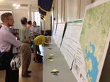
In 2014, the
Planning Department worked closely with community stakeholders, City agencies,
and a consultant to prepare a draft plan. A final public meeting is
planned for 1st quarter of 2015, prior to the release of the final
draft of the Master Plan and its adoption by Planning Commission in Summer of
2015.
Local Impact Aid Spending Plans
The Planning Department has worked
with the communities and Local Development Councils around Pimlico Racetrack
and the new Horseshoe Casino to develop spending plans for gaming revenue that
is allocated to these areas in the form of Local Impact Aid. The approved FY15 Pimlico Local Impact Aid Spending Plan and the draft FY 16 Pimlico Local Impact Aid Spending Plan were reviewed by Pimlico Community
Development Authority.
Key projects in the Pimlico area include pre-development activities in the Park
Heights Major Redevelopment Area, Park Heights human services, and improvements
to Northwest Park.
The approved FY 15 Casino Area Local Impact Aid Spending Plan and draft FY16 Casino Area Local Impact Aid Spending Plan were reviewed by the Baltimore
Casino Local Development Council. Key projects in the
Casino area include a complete streets initiative, Community Benefits district,
and an Employment Connection Center.
Capital
Improvement Program
To
guide the City in making necessary physical improvements, the City Charter
requires the Planning Department to annually prepare a six-year Capital
Improvement Program (CIP) for approval by the Planning Commission, Board of
Finance and Board of Estimates. The first year of the six year program is the
budget year and becomes the basis for the capital component of the Ordinance of
Estimates, adopted by City Council. In 2014, the Planning Commission
approved the FY15-FY20 Capital Improvement Program,
which includes $900 million for capital improvements in FY 15. In
addition, in 2014, the Planning Department successfully completed the loan
authorization process for the FY16 and FY17 General Obligation bonds,
with more than 70% voter support for each bond ballot question.
RESEARCH AND STRATEGIC PLANNING
The Research and Strategic Planning (RSP) Division provides
information, research, and analysis that guides the City’s planning related
policies and activities. The Division provides City agencies and the Mayor’s
Office with data analysis, research reports and funding opportunities for
programs like housing, community development, transportation, the natural
environment, the economy, real estate and public health. The Division works
with information and mapping technologies, such as Geographic Information
Systems or GIS, to help inform elected officials, developers, planners and communities
of the impact and status of development in the City.
You can learn more about our GIS services and view our interactive map library by clicking on the image to the right. |
|
 |
RSP staff also
participates in cooperative forecasting activities at the Baltimore
Metropolitan Council and plays a key role in the analysis of periodic data
releases from the U.S. Census Bureau on citywide, community and neighborhood
levels.
Economic
Development Strategic Planning
In 2014, the Planning Department worked with the Baltimore
Development Corporation (BDC) to complete a new Comprehensive Economic
Development Strategy (CEDS). With the help of a grant from the U.S. Department
of Commerce’s Economic Development Agency (EDA) and internal funding, a
consultant was brought on board and the public planning process launched in 2013.
This process included extensive community outreach with businesses, relevant
organizational stakeholders and residents. A summary of the CEDS and a
downloadable copy of the plan itself is available from the BDC website.
Inner Harbor 2.0
Throughout 2014, RSP staff worked with our partners at the
Waterfront Partnership to revise and amend Inner Harbor 2.0, a new master plan,
released in late 2013, for the public spaces around Baltimore’s Inner Harbor. In 2014, following extensive feedback from
the nearby communities, businesses and partner organizations, the plan was
revised, and will be re-released in 2015. Stay
tuned to future editions of the Compass to learn more about Inner Harbor 2.0
and future public meetings or visit the Inner
Harbor 2.0 website.
 Neighborhood Census Profiles
 In 2014, the Planning Department released a new set of data
tools for online use, that feature updated neighborhood profiles. The
new neighborhood profiles combine population statistics from the 2000
and 2010 Census counts with socioeconomic data from the
2006-2010 American Community Survey 5-Year Estimates. The American Community Survey (ACS) is the
U.S. Census Bureau’s annual household survey, which replaced the ‘long form’
data collected during the 2000 Census.
The neighborhood profiles can be accessed in two ways. A direct link to the data tables can be found here. In addition to data tables, the Planning Department created an
interactive map that highlights changes in population between the 2000
Census and the 2010 Census, available here (best viewed in Chrome or Firefox)..
|
By the Numbers...
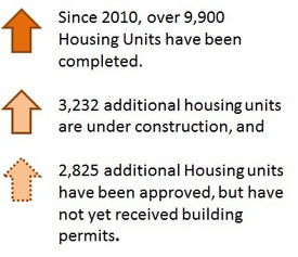
On a Quarterly basis, RSP tracks and reports changes in the housing development pipeline to show progress towards a growing City. By tracking the number of new housing units completed, approved, and in the planning pipeline, we will be better able to guage progress towards the Mayor's goal of adding 10,000 families over the next 10 years. Between 2010 and 2014, the following changes have taken place in the housing market:
 |