Friday update: KY 15 remains closed at Panbowl Dam in Jackson
River receding, but officials remain cautious; numerous state roads in Breathitt, other counties still closed due to flooding
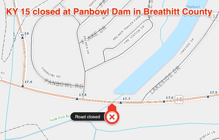
JACKSON, Ky. – KY 15 at Panbowl Dam in Jackson will remain closed to traffic until at least Saturday as a precautionary measure as record floodwaters on the North Fork of the Kentucky River recede.
The road was closed at milepoint 17.7 within the city limits of Jackson, between Lakeside Drive and the KY 15/KY 30 intersection, at 9:30 p.m. Thursday as a precautionary measure as floodwaters threatened to overtop the highway embankment. Water never did flood the highway before the river crested during the overnight hours Friday morning. The highway traverses Panbowl Dam; the lake was impounded when this section of KY 15 was built in the early 1960s.
Kentucky Transportation Cabinet (KYTC) personnel will remain on site to monitor the situation. Emergency response vehicles will be allowed to travel through the closure. KYTC will assess the situation again Saturday morning and will decide if the road will reopen or remain closed.
KY 15 between Jackson and Hazard reopened to traffic Friday morning. The route had been blocked south of Jackson near Lost Creek. The southbound lanes of KY 15, approximately two miles north of Jackson, were blocked by water Friday morning, and two-way traffic was being flagged in the northbound lanes. Normal traffic is expected to resume there once the river recedes.
Due to the ongoing KY 15 closure in Jackson, any long-distance travelers from central Kentucky bound for Hazard or other locations such as Hindman or Whitesburg should use I-75 and the Hal Rogers Parkway through London and Manchester; or the Mountain Parkway, KY 114, US 23, and KY 80 through Salyersville and Prestonsburg.
Southern Breathitt and northern Perry counties in the upper Kentucky River valley appear to be the hardest hit. As water goes down, crews are arriving to assess any damage to pavement, embankments, drainage pipes, and bridges.
Secretary Jim Gray and other officials from KYTC and the Federal Highway Administration were on hand Friday morning to tour flood-ravaged Breathitt and Perry counties and evaluate damage.
As of Friday morning, the following roads are known to be closed in the upper Kentucky River valley:
Breathitt County
KY 30 east between Quicksand and the Magoffin County line due to high water.
KY 52 near Elkatawa due to high water.
KY 205 (old KY 15) near Vancleve due to high water.
KY 476 in numerous locations between the Perry County line and Lost Creek due to high water and debris.
KY 1098 (South Fork) in numerous locations due to high water.
KY 1110 near Whick due to high water.
KY 1278 near Watts and River Caney due to high water and breaks in pavement.
Lee County
KY 1411 (South Fork) between milepoints 0-3 due to high water.
Owsley County
KY 2022 (Squabble Creek) in various locations due to breaks in pavement.
Perry County
KY 28 at the KY 451 intersection near Chavies due to high water.
KY 451 in numerous locations between Coal Harbor and Chavies due to high water and breaks in pavement, including near mile marker 12 where the road will remain closed indefinitely due to a washed-out drainage structure.
KY 476 in various locations between Rowdy and the Breathitt County line due to high water and debris.
KY 550 near Dwarf due to high water.
KY 3351 near Pigeonroost due to bridge damage.
In other watersheds such as the lower Kentucky River, Red River, and Licking River valleys, river flooding has closed roads such as KY 1571, KY 1645, KY 3328, and KY 3329 in Estill County, KY 7 in Magoffin County, KY 364 in Morgan County, and KY 613 in Powell County. These locations are in flood-prone areas and the highways frequently close due to high water.
Motorists are urged not to drive through flooded areas, especially during overnight hours when hazards such as debris on the pavement or washed-out sections of roadway may not be visible.
###
|