Proposed redistricting map information
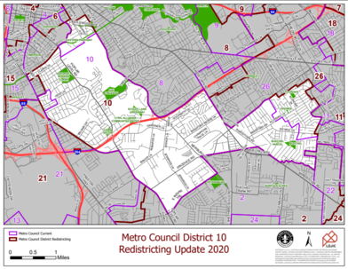 Every 10 years after the Decennial Census, Metro Louisville is required by law to redraw the boundaries for each of the 26 Council Districts to account for changes in population according to local, state, and federal rules governing the process. The US Census Bureau provides population and demographic data to states and localities that are tailored to the task of redistricting. The Louisville Metro Council formed an Ad Hoc Committee to review the current districts and propose new district boundaries based on population changes.
Population growth in Louisville Metro has been to the east and southeast for many years. To keep the population of districts as nearly equal as is reasonably possible, districts have also moved east and southeast, including District 10. That's why the northern boundary of District 10 has changed.
The proposed maps are linked here. Links to share comments and more information about the process are here.
Metro Council addressing public safety, affordable housing, public health and more with ARP funding ordinance

Metro Council members are working on an ordinance proposing to spend $262.9 million of federal American Rescue Plan (ARP) funding on critical initiatives. These aim to address public safety challenges and homelessness, build more affordable housing for the community, continue to tackle the COVID-19 pandemic, and recognize the efforts of public employees.
This ordinance will be heard and considered by the Metro Council Budget Committee on November 4.
For details on this ordinance, follow this link.
|
|