

NEW 2022 ArcGIS Virtual Training Classes for State and Local Partners
The Geographic Information Office (GIO) is offering virtual training classes for state and local partners. Hard copy training materials are shipped to your preferred location. Students will access a virtual machine, loaded with the software, that will allow you to work through the hands-on labs. Space is limited, register today. Registration
|
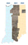
2022 Orthoimagry Planning
Planning for the spring flight of the eastern 1/3 of the state of Indiana is underway. Please contact Shaun Scholer at sscholer@iot.in.gov or review the latest presentation and slides for more details:
https://www.in.gov/gis/indiana-imagery/
Download 2021 Orthoimagery
The 2021 spring orthoimagery of the center 1/3 of the state is available for download. Click here for instructions on how to download.
|

|
GIO Modernizing GIS Desktop and Enterprise Applications
As seasons change so does the technology in which we do our jobs. Ever changing goals, projects, and deadlines keep us moving forward with the tools we choose to complete our jobs. The core tool within the ArcGIS for Desktop, ArcMap has been a reliable and a go to tool for many. However ESRI has announced that ArcMap will be retired and all desktop development will be focused on ArcGIS Pro and other future technologies. This change presents challenges to organizations in regards to migrating existing workflows, custom tools, and user training. As part of the GIO GIS training options we have several beginner ArcGIS Pro options available for users looking to begin their transition to ArcGIS Pro. Below are links to ESRI's blog post updating users on ArcMap support as well as training options to get you started.
|
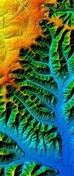
OpenTopography Fundraiser for new Indiana QL2 3DEP LiDAR Data Hosting
In 2020, new 2016-20 statewide Quality-Level-2 (QL2) LiDAR was completed for Indiana. This new statewide LiDAR data is twice as accurate, twice as detailed, and up to eight-years newer than Indiana’s original 2011-13 LiDAR. IGIC is now conducting a fundraiser to raise a one-time investment of $50,000 to add this new 2016-20 statewide LiDAR dataset to our existing IndianaMap OpenTopography site. DONATE
|
https://content.govdelivery.com/accounts/INIOT/bulletins/306b5be
|
|