
|

Paul McBride Joins the GIO Team as Geospatial Technical Specialist
We are honored to announce that Paul McBride will soon be joining our GIO Team as a Geospatial Technical Specialist. Paul is a GIS professional with 12 years experience. He has spent the last 8 years as the GIS Manager for the Madison County Council of Governments (MCCOG) and has been responsible for building and managing their enterprise GIS system. Paul spends his personal time enjoying his family and also staying healthy and fit. His first day with the GIO will be Thursday, December 16th.
|
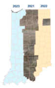
2021-2024 Indiana Statewide Orthophotography Virtual Roadshow
|

NEW 2022 ArcGIS Virtual Training Classes for State and Local Partners
The Geographic Information Office (GIO) is offering virtual training classes for state and local partners. Hard copy training materials are shipped to your preferred location. Students will access a virtual machine, loaded with the software, that will allow you to work through the hands-on labs. Because our instructor (Irv Goldblatt) is retiring there is a price increase, but it is still an amazing deal! Space is limited, register today. Registration
|

OpenTopography Fundraiser for new Indiana QL2 3DEP LiDAR Data Hosting
In 2020, new 2016-20 statewide Quality-Level-2 (QL2) LiDAR was completed for Indiana. This new statewide LiDAR data is twice as accurate, twice as detailed, and up to eight-years newer than Indiana’s original 2011-13 LiDAR. IGIC is now conducting a fundraiser to raise a one-time investment of $50,000 to add this new 2016-20 statewide LiDAR dataset to our existing IndianaMap OpenTopography site. DONATE
|
https://content.govdelivery.com/accounts/INIOT/bulletins/300a854
|
|