
2021 ArcGIS Virtual Training Classes for State and Local Partners
The Geographic Information Office (GIO) is now offering virtual training classes for state and local partners. Hard copy training materials are shipped to your preferred location. Students will access a virtual machine, loaded with the software, that will allow you to work through the hands-on labs. The instructor (Irv Goldblatt) will be able to see your screen and help out with any issues during the class. Space is limited, register today. Registration Training Portal
|

Maps are a critical weapon in our fight against COVID-19. We can be smarter about how we use them.
|

ArcMap End of Support Announced
|
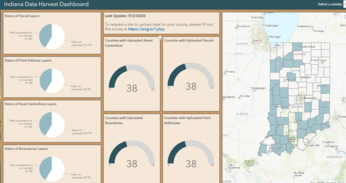

2020 Indiana Data Harvest Program
2020 Data Harvest Program is almost complete, thanks to the support of our counties and partners. Due to this collaboration, Indiana has a new, complete statewide parcel dataset. The Geographic Information Office collaborates across the state to obtain the following datasets (addresses, parcels, road centerlines and government boundaries). For more information and to track county participation, visit the Dashboard.
Having trouble viewing this email? View it as a Web page.
|

|
|