Indiana Recognized for its Outstanding GIS Services
The Indiana Geographic Information Office (GIO) and the Family and Social Services Administration (FSSA), were recently recognized for their achievement and leadership shown throughout the COVID-19 pandemic.
This award recognizes special geospatial projects developed through teamwork that demonstrate commitment to working with others in the Indiana GIS community toward a common goal, while performing important, often pioneering work, to create an outstanding information resource. Award
|

Shaun Scholer Joins the GIO Team as GIS Program Director
We are honored to announce that Shaun Scholer will soon be joining our GIO Team as the GIS Program Director. Shaun is currently the Wayne County/City of Richmond GIS Coordinator and IGIC Treasurer. Shaun brings expertise in imagery, data storage, system migration, upgrades and cross-agency collaboration, among many other attributes and experiences. His first day with the GIO will be Monday, October 19th.
|
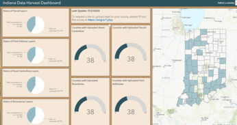

2020 Indiana Data Harvest Program
2020 Data Harvest Program is wrapping up. IC 6-1.1-4-25(b)(13) requires a county to submit parcel data in a GIS file format to the Indiana Office of Technology. GIO office will work with the Counties to also obtain the following datasets (addresses, centerlines and government boundaries). For more information to do see which counties are participating visit. Dashboard
|
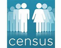
Improving the 2020 Census with GIS Technology
Government Matters: Jack Dangermond, founder and president of Esri, discusses the role that geographic tech plays in government and how new technologies will help the census. Read more.
|

Four Major Trends in the GIS Market by 2024
The global geographic information system (GIS) market size is anticipated to witness consistent growth. This growth is attributed mainly to the rising use of location-based services across the industrial landscape. Geospatial World
Having trouble viewing this email? View it as a Web page.
|
|
|