

2020Preview of IGIC’s Upcoming 2020 Virtual Conference: “A Changing World”
It’s almost here! The Indiana Geographic Information Council’s Annual Conference has gone virtual for 2020. The first two days of the conference will include the dynamic programming you've come to expect from the annual conference, while day three will feature our Geospatial Coordinator's Forum. Registration/Information
Check out our video from IGIC president Kari Hicks. Kari previews the upcoming conference, highlights featured keynote presenters and explains how this year’s unique event came together. Video
|
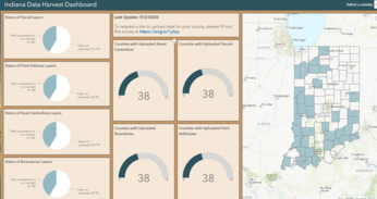
2020 Indiana Data Harvest Program
2020 Data Harvest Program has begun. IC 6-1.1-4-25(b)(13) requires a county to submit parcel data in a GIS file format to the Indiana Office of Technology. GIO office will work with the Counties to also obtain the following datasets (addresses, centerlines and government boundaries). We are requesting that the Counties provide this by September 23, 2020. More Information

DNR Agency GIS Coordinator
The Indiana Department of Natural Resources is looking for a highly motivated and skilled individual to take on the role of Agency GIS Coordinator. This Senior Geographical Information System (GIS) Specialist will serve as a top level technical expert for the Department of Natural Resources in the highly specialized areas of geographic information systems (GIS) analysis and programming, and be responsible for coordinating geographic information systems activities for the Agency. Job Posting
|

Report Sick or Dead Wildlife on NEW DNR Website
Indiana DNR has launched a new website for public reporting of sick or dead wildlife. The new online tool is designed to collect information about Indiana wildlife that appears sick or has died without an apparent cause. Reports are added to an active database that helps DNR track wildlife health over time and detect disease outbreaks. Site
|
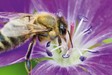
New Earth Challenge App Update Connects Citizen Science To Civic Action
Forbes: The latest update to the Earth Challenge 2020 project is ongoing and includes a push to preserve pollinators. Read more
Having trouble viewing this email? View it as a Web page.
|
|