Indiana Office of Technology sent this bulletin at 07/28/2020 03:51 PM EDT
Geographic Information Office NEWS
Office of the GIO
State GIS Community Strives for Greater Diversity
Geospatial information systems teams in and around state governments are working to improve their diversity. Article
NSGIC: State Spotlight: Indiana
Learn about Indiana's #GIS successes and challenges in this new State Spotlight from Megan Compton, Indiana State GIO - Indiana Geographic Information OfficeNSGIC Article
Maps are (Still) Important Again
Maps are important! They have been helping us understand and navigate our world since the beginning of human history and they are helping today as we are reminded in every news cycle. GIS Cafe Blog
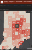
COVID-19 Impact on Indiana Businesses
In this Story Map, The Polis Center provides an analysis of the impact of COVID-19 on various types of businesses and geographies. Story Map
IndianaMap 2.0 Survey Results
GIO received great feedback from the IndianaMap 2.0 survey last month. See the overview of the survey results and feedback from the GIS community that will guide the future capabilities of the IndianaMap. Survey Results
What's Coming in ArcGIS Online
On June 30, Esri plans to update ArcGIS Online. The update will deliver highly requested capabilities including a new home page editor, group layers in Map Viewer Beta, and additional reports for administrators. Info
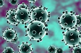
GIS based mapping and analysis has been used effectively by WHO, UNICEF and CDC during the outbreak. Article
Virtual Esri User Conference
Join Esri for the largest, virtual GIS event, July 13-15, 2020. Get access to online training, virtual networking, the Plenary Session, and much more. Registration
IndianaMap News - Layer Updates
Updated four GIS layers onto the map, provided by the Office of Land Quality, (IDEM). View the Map