|
The Division of Water “Best Available” Floodplain Layer
By David Knipe, DNR
For many years, the DNR Division of Water has assisted Indiana communities in determining base flood elevations (BFEs) and floodway limits for streams that did not have detailed floodplain information shown on their Flood Insurance Rate Maps (FIRMs). Typically, this included asking requestors for survey data, then using that data to run hydrology and hydraulic models to determine floodplain limits on a case-by-case basis.
Because this process took months to complete, both from obtaining the survey data and the modeling by the Division of Water, floodplain management activities suffered due to the time lag. However, with the advent of detailed GIS data, namely LiDAR elevation data, many of the traditional barriers to completing high-level floodplain information have been removed.
The Division of Water has completed a dataset for the state that incorporates the detailed level-floodplain data included in the FEMA FIRMs and enhanced it with a lower-level, but still quality, floodplain data for the majority of all streams in Indiana. This dataset is known as the “best available” floodplain layer, due to the phrasing of the standard local floodplain ordinance in Indiana, which requires the use of “best available” data to make sound floodplain management decisions when the needed information is not available on the FEMA FIRM.
The dataset features flood elevations for five annual chance flood return periods (10%, 4%, 2%, 1% and 0.2%), as well as floodplain and floodway limits for more than 18,000 miles of stream that previously only had Zone A or Zone X designations on the FIRMs. Along with the 4,000 miles of stream published on the FIRMs with elevation and floodway data, this dataset provides floodplain data for more than 22,000 miles of stream in Indiana, covering every major waterway in the state, along with many critical tributaries.
This project was funded through a series of grants and State funding sources, the largest source being from the U.S. Department of Housing and Urban Development’s Disaster Recovery Enhancement Fund (DREF) related to the 2008 flooding disasters in Indiana. This grant was administered by the Indiana Office of Community and Rural Affairs (OCRA). For areas not covered by the DREF grant, FEMA funded work through the Cooperating Technical Partner (CTP) grant agreement in place with the DNR, and some State funding was used to cover gaps in the dataset.
Additionally, the Maumee River Basin Commission funded the development of data within the Maumee River Basin, and provided that data to the Division of Water for inclusion in this dataset. The majority of the modeling and processing of these floodplains was done by the Engineering Service Center staff within the Division of Water, and the compilation of the merged floodplain data was completed by the Polis Center at Indiana University. Some modeling and other functions were completed by engineering contractors within the state.
This dataset is presented as a statewide GIS data layer, and can be viewed on a number of platforms and portals, including the Indiana Floodplain Information Portal (INFIP). Data can be downloaded by county by individuals who want to work with the data locally, and the data is available as a Representational State Transfer (REST) service. This dataset is a companion to FEMA’s National Flood Hazard Layer (NFHL), which is a digital representation of the FIRM’s.
Because the FIRM’s must be used to determine requirements for flood insurance offered through the National Flood Insurance Program (NFIP), the “best available” dataset does not replace FEMA data as the official dataset of the NFIP. However, for floodplain management applications, including planning, construction, and determining limits of jurisdiction for the Indiana Flood Control Act, the “best available” layer should be used.
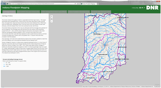 Indiana Floodplain Mapping Story Map
Best Available Floodplain Data Webinars
A series of webinars are planned to introduce these maps, https://arcg.is/1e1P8j, to community planners, engineers, surveyors, realtors and other stakeholders. Information on the webinars is as follows:
Feb. 28: 1:30 to 2:30 p.m. EST
March 14: 1:30 to 2:30 p.m. EST
March 21: 1:30 to 2:30 p.m. EST
View the webinar at https://dnr.adobeconnect.com/flood/.
The phone number to listen is (605) 313-4421 Access code: 546257
Where to Find the Data
Models developed for the “best available” floodplain layers are available on the Indiana Hydrologic & Hydraulic Model Library online.
Countywide extracts are available online.
Check out the story map at https://arcg.is/1e1P8j to see the comparison of FEMA’s National Flood Hazard Layer and the DNR “best available” floodplain layer.
Community Use of Best Available Data
By Doug Wagner, DNR
How are communities to use the “best available” data layer?
Communities must refer to the “best available” data layer when permitting development in or near “A” zone flood hazard areas designated on the community’s Flood Insurance Rate Map (FIRM) that is currently effective. “A” zones are areas where only an approximate study was completed prior to the effective FIRM. With the further studies now completed by the DNR Division of Water, more detailed information is available in the “best available” layer and must be used in accordance with the general provisions article of the local floodplain ordinance.
The basis for establishing the regulatory flood data section of the general standard is to provide the zones and flood insurance study information for the community. This section of the ordinance also states that in “A” zones (or in the absence of published maps), the best data available, as provided by the DNR, is to be used, provided the upstream drainage area of the subject site is greater than one square mile.
A community can now look at this layer on INFIP and determine if a floodway permit is required. The community also has the responsibility of requiring that the base flood elevation (BFE) be provided by the DNR in accordance with 312 IAC 10-3-3.
When looking at the “best available” data layer, local administrators will see drastic changes in some areas and minor differences in others. The most significant noted change for any area is the delineation of the floodway in the “A” zones. Some communities will see new areas designated that were not previously mapped. This situation makes it extremely important that local administrators review their flood hazard areas to ensure compliance with the local ordinance.
The more-accurate limits of the floodplain will at some point be included on the FIRMs. Requiring any development to be in compliance with the NFIP and community regulations at the time of permitting will save a great deal of time and expense in the future.
So, There is New Floodplain Data… What Does It Mean for Me?
By Alysson Oliger, DNR
Owning property near a stream or floodplain calls for extra concerns and considerations. You want to protect the stream and avoid any damages to your property—and you must apply for additional approvals for many projects.
Whether you are interested in seeing whether there is any new floodplain information for your property or planning a project, you will find the “best available” floodplain dataset to be a helpful resource.
Knowing Your Risk
If you own property in a mapped floodplain, you are probably familiar with FEMA’s Flood Insurance Rate Maps (FIRMs). And if you have a mortgaged structure in a mapped floodplain, you are probably familiar with FEMA’s flood insurance requirements as well.
However, did you know that all streams have a floodplain, regardless of whether the floodplain is mapped?
And where there is floodplain, there is a risk of flooding. If your property lies in a FEMA-mapped Special Flood Hazard Area (SFHA), then the risk of flooding is high, and flood insurance is required if you carry a federally backed mortgage. However, regardless of the zone in which your property lies, the risk of flooding is always present.
While the effective FEMA maps must be used for flood insurance requirements, the “best available” floodplain dataset can help show your property’s risk in areas not mapped by FEMA. This new dataset contains floodplain data for more than 80% of streams in Indiana, which is a significant increase from the number of streams represented in the FIRMs.
If the “best available” floodplain layer shows a floodplain in an area outside of the FEMA-mapped SFHA, this means the DNR Division of Water has newer data that better reflect the risk in the areas of your property that are prone to flooding. The “best available” floodplain dataset shows you the areas to avoid developing, and can help you determine whether to purchase flood insurance. Flood insurance is always recommended, and can be cheaper if the property is located outside of FEMA-mapped SFHAs.
Planning and Applying for Construction Permits
Indiana’s Flood Control Act was enacted to prevent and limit damage from floods. As such, the Division of Water has jurisdiction over most construction activities in the floodway. Construction in the floodway area requires a permit from the Division of Water. The floodway is the portion of the floodplain required to convey the flow of water during a regulatory (1% annual chance) flood event. A floodplain, floodway, and flood fringe exist for every waterway, even if it has not been delineated on a map.
With the development of the “best available” floodplain data, more than 80% of the streams in Indiana now have a mapped floodway. This means that if you are looking to build a barn or to place fill for a driveway, reinforce a stream bank, or any other construction activity in the floodplain or along a stream, you can now easily determine whether your project is located in a floodway and will therefore require a permit from the Division of Water.
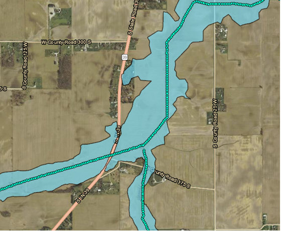
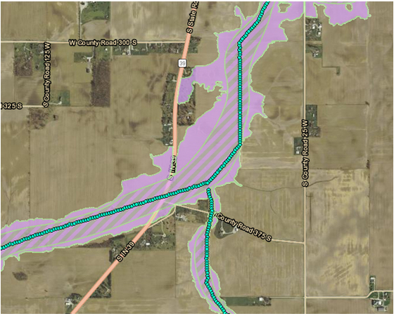
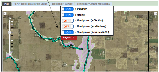
In the example below, you will see the difference between the FEMA-published FIRM (the “effective” floodplain layer) and the “best available” floodplain layer. The “best available” floodplain layer shows the limits of the floodway, which embrace the area under the DNR’s jurisdiction under the Flood Control Act, with the diagonal lines.
Published “effective” floodplain layer:
 Division of Water‘s “best available” floodplain data layer:
 Prior to development of the “best available” floodplain data, property owners needed to submit a request for a Floodplain Analysis and Regulatory Assessment (FARA) to the Division of Water to determine the limits of the floodway in areas without a FEMA-mapped floodway.
In the example above, the limits of the floodway are not mapped by FEMA, but are shown in the “best available” floodplain layer. The floodway limits shown can be used for permitting purposes. There is no longer the need to request DNR to determine the floodway limits—the map already shows where the floodway is located. However, there are still stretches of stream that are not mapped in the “best available” floodplain layer. In these cases, a request for a FARA should still be requested from the Division of Water.
It is important to note that your local floodplain administrator may still require you to obtain a FARA from the Division of Water for their records when requesting a local permit. A FARA may also be necessary to verify the BFE when applying for a Letter of Map Change (LOMC), such as a Letter of Map Amendment. In these cases, and where there is not a mapped floodway, you can submit a request for a FARA directly from INFIP. See the article “How to View the Best Available Floodplain Data” for details.
How to View the Best Available Floodplain Data
By Alysson Oliger, DNR
Most people will find the Indiana Floodplain Information Portal (INFIP) the easiest way to view the “best available” floodplain layer. To access INFIP, simply go to INFIP.dnr.IN.gov, or navigate to the map from the Division of Water’s webpage. You can zoom to your property by using the address finder, or otherwise navigating through the map.
If you wish to view the FEMA effective floodplain, it is the default layer; so you will immediately see the currently effective FIRM mapping.
Once you have zoomed into a site on the map, you can access the “best available” floodplain data layer by clicking on the “Layers” tab at the top of the map.
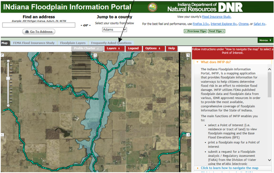 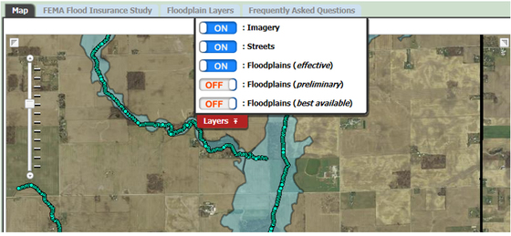 To view the “best available” floodplain layer only, turn off the Floodplains (effective) layer and turn on the Floodplains (best available) layer. If a comparison of the FEMA “effective” floodplain layer and the “best available” floodplain layer is desired, simply turn on both.
 You can export a map depicting both the “effective” and “best available” floodplains directly from INFIP. More detailed instructions are available on INFIP.
Technical Information
By Dave Knipe, DNR
The floodplains for the “best available” floodplain data layer were modeled using a suite of GIS tools and scripts utilizing detailed GIS data for elevation and stream centerlines.
Hydrology
The peak discharge values used in the model were derived from the U.S. Geological Survey (USGS) StreamStats application. DNR staff selects locations along the stream where peak discharge values are needed along the stream, and runs a script to request discharge information from the StreamStats data web service. The peak discharge values are then fit to a log-log plot, and the best-fit line is used for the peak discharges in the hydraulics model.
Hydraulics
The U.S. Army Corps of Engineers’ HEC-RAS program (version 4.1.0) was used to determine the flood elevations along each stream and as a basis for delineating the regulatory floodplain. Elevation data for the cross sections and floodplain delineation were from a Digital Elevation Model (DEM) for the State of Indiana, which was derived from LiDAR data taken from 2008 through 2013. Stream centerline data were largely derived from the local resolution USGS National Hydrography Dataset recently developed by the State of Indiana.
This stream centerline data is at a scale of 1:2400, and therefore is of high enough resolution for use in hydraulic modeling. Cross sections were selected and placed by DNR Division of Water staff. Derivation of all other parameters were automated, and then reviewed and modified as necessary:
- Channel bank stations are derived based on a study of undisturbed natural channels around the state by the USGS.
- The distance between cross sections for the channel is measured from the stream centerline. For the left and right overbank distances, a point is determined on each section at 0.2 times the cross-section length from the center point of the section, to the left and right.
- The service uses the USGS National Land Cover Dataset (2006) for derivation of the Manning’s “n” values for the channel and overbank.
Floodplains
Floodplain delineations are based on the HEC-RAS modeling results and mapped out using GIS methodologies and the DEM derived from the LiDAR flights from 2008-2013. Depth grids and water-surface elevation grids were derived along with the floodplain information, and are available upon request. Flood elevation points were also derived, determining the base flood elevation (1% annual chance flood) for a stream every 50 feet along the stream centerline. These points are used in the Indiana Floodplain Information Portal (INFIP).
Floodways
Along with the five profiles, Division of Water staff developed floodway delineations for each stream studied. These floodways, being derived from “approximate” models, are not to the standard to be published by FEMA, but do meet the standard to be used to determine jurisdiction for the Indiana Flood Control Act. Floodways were determined using a semi-automated process for drawing smooth and consistent floodway limits within HEC-RAS. Each separate stream was then integrated into the statewide dataset, using the NFHL as a base.
Zone A Floodplain Mapping Project Receives Recognition
The Indiana DNR Zone A Floodplain Mapping project was awarded the 2018 Excellence in GIS Award (State or Federal Agency) by the Indiana Geographic Information Council (IGIC), and the 2018 Outstanding Floodplain Project by the Indiana Association for Floodplain and Stormwater Management (INAFSM).
THANK YOU
Thanks to those contributing to this issue: Dave Knipe, Alysson Oliger, Doug Wagner, George Bowman, Ryan Mueller, Marty Benson, Don Kaczorowski, Anita Nance, and Ed Reynolds.
Editor – Darren Pearson
The work that provides the basis for this newsletter was supported by funding under a cooperative agreement with the Federal Emergency Management Agency. The author and publisher are solely responsible for the accuracy of the statements and interpretations contained in the publication. Such interpretations do not necessarily reflect the views of the federal government.
Waterlines is produced biannually as a public service by the DNR Division of Water.
Waterlines is available on the web at dnr.IN.gov/water.
Having trouble viewing this email? View it as a Web page.
|