|
For Immediate Release: Monday, Oct. 22, 2018
DES MOINES – Iowa Secretary of Agriculture Mike Naig today commented on the Iowa Crop Progress and Condition report released by the USDA National Agricultural Statistical Service. The report is released weekly from April through November.
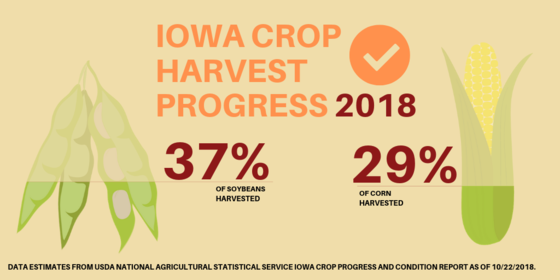
“Many farmers were able to get back into their fields this past week, but we still remain well behind the five-year average. The 29 percent of corn harvested is 4 days behind average and the 37 percent of beans harvested puts us 12 days behind,” Naig said. “Our farmers can make tremendous progress in a week if conditions allow. Farmers harvested 65 percent of soybeans in a single week back in 2013 and 30 percent of corn in a week in both 1993 and 2013. So, hopefully the drier weather stays in place and farmers can start to catch up.”
The Iowa Farm Bureau Federation and Decision Innovation Solutions have analyzed Iowa Crop Progress and Condition Reports going back to 1990 looking at the largest week of corn and soybean harvest each year. Additional information about their analysis can be found here.
The weekly report is also available on the Iowa Department of Agriculture and Land Stewardship’s website at www.IowaAgriculture.gov or on USDA’s site at www.nass.usda.gov/ia. The report summary follows here:
CROP REPORT
Sunshine and a break from substantial precipitation got Iowa farmers back in the fields with 4.4 days suitable for fieldwork during the week ending October 21, 2018, according to the USDA, National Agricultural Statistics Service. Activities for the week included harvesting corn and soybeans, baling stalks and planting cover crops.
Topsoil moisture levels rated 0 percent very short, 0 percent short, 65 percent adequate and 35 percent surplus. Subsoil moisture levels rated 0 percent very short, 2 percent short, 61 percent adequate and 37 percent surplus.
Twenty-nine percent of the State’s corn for grain crop has been harvested, 3 days ahead of last year but 4 days behind the five-year average. Farmers in southeast Iowa have neared the halfway point of corn for grain harvest while farmers in the northeast have not yet harvested one-fifth of their corn for grain. Moisture content of field corn being harvested was at 19 percent. Corn condition rated 68 percent good to excellent. Soybean harvest was 37 percent complete, 12 days behind the average. This is the smallest percentage of the soybean crop harvested by October 21 since 1985. Soybean condition rated 65 percent good to excellent.
Pasture conditions rated 55 percent good to excellent. Pastures have responded well to recent precipitation and cool temperatures. Cattle lots are still muddy but improving.
IOWA PRELIMINARY WEATHER SUMMARY
By Dr. Justin Glisan, State Climatologist, Iowa Department of Agriculture and Land Stewardship
After an extremely wet start to October, abnormally dry conditions returned to Iowa. Statewide weekly precipitation deficits ranged from 0.20 to 0.70 inches. Northern Iowa observed the wettest conditions; Mason City (Cerro Gordo County) reported the week’s highest total accumulation of 0.61 inches. Unseasonably cool weather continued with average temperatures five to ten degrees below average. On Monday (15th) the remains of a cold front moved out of southeastern Iowa. Burlington (Des Moines County) reported 0.48 inches of rain. Tuesday (16th) through early night on Thursday (18th) was dry statewide with average highs in the middle to upper 50s in the eastern third of the state and lower to middle 60s across the rest of Iowa. Multiple locations in Iowa’s northwestern quadrant observed highs above 70 degrees on Wednesday (17th), up to 10 degrees above normal. A cold front with rain showers moved into Iowa Thursday night and lingered through late morning on Friday (19th). The heaviest rainfall occurred in northern Iowa; St. Ansgar (Mitchell County) recorded 0.50 inches. Much of Iowa’s southern two-thirds received between a trace and a tenth of an inch. Cloud cover moved out of Iowa later in the day Friday into Saturday (20th). A second cold front sped through Iowa on Saturday bringing cooler air and windy conditions statewide. Stations in eastern Iowa observed sustained winds between 20 to 30 miles per hour with gusts in the 40-50 mph range in the late afternoon. Sunday (21st) was pleasant as high pressure dominated the region. Skies were generally clear with unseasonable coolness. Red Oak (Montgomery County) and Shenandoah (Page County) reported the week’s high of 73 degrees on the 19th, nine degrees above average. Stanley (Buchanan County) observed the week’s low temperature of 18 degrees on the 21st, 17 degrees below average.
 -30-
For more information, contact Dustin Vande Hoef, (515) 281-3375 or (515) 326-1616 (cell) or Dustin.VandeHoef@IowaAgriculture.gov
|