Withlacoochee River System Update - 10/1/2026
Southwest Florida Water Management District sent this bulletin at 10/01/2026 06:29 PM EDT
 |
Water Levels Below Normal as Dry Season Begins
Rainfall:
- Our dry season officially begins today – October 1st.
- Starting this month, we historically average only about 2-3 inches of rain per month from now through next May.
- That’s not a friendly statistic when we think about how low our water levels already are, and just how much lower they could get before next year’s rainy season.
- But rainfall doesn’t always behave like we think it will.
- The forecasters are predicting a wetter than normal fall and winter, due to a strong El Nino weather pattern this year.
- That could be the saving grace we need to help dig us out of this extended drought.
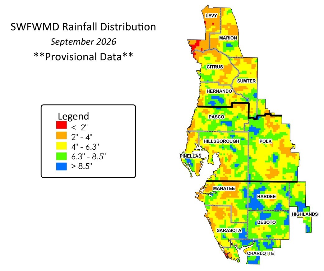
- In September, our region received 4.8 inches of rainfall, lower than the historical average for the month (6.3 inches).
- Most of the Withlacoochee River’s watershed received below average rainfall in September, except for a couple areas in the Green Swamp.
- Water levels in our region’s lakes, rivers, and the aquifer remain very low for this time of year.
- So far in 2026 (January – September), we’ve received a total of 38 inches of rain, well below the historical average for the first 9 months (46 inches).
- Aquifer (groundwater) levels also remain below normal, currently in the 20th percentile for this time of year, and lower than last year (29th percentile). Remember, the 50th percentile is average.
- As we enter the historically drier months, getting above average rainfall will be critical if we’re going to see our water resources bounce back anytime soon.
- The figure below shows how much rainfall different areas received last month. The green and blue areas had above average rainfall in September.
Withlacoochee River (from the Green Swamp downstream past Hwy 200):
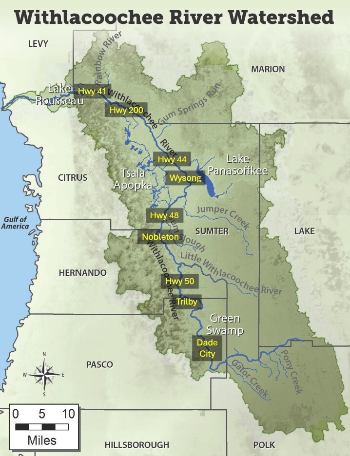
- The Withlacoochee River remains very low compared to the normal conditions we’d expect to see at the end of our wet season (June-September).
- There were recent flood warnings at Dunnellon, which were caused by heavy hydrilla growth in that section of the Withlacoochee (not rainfall or river flows). See more about that in the Lake Rousseau section below.
- Earlier in September the Green Swamp did get a few days of heavy rainfall.
- It was enough to finally get decent water flowing out of the Withlacoochee River’s headwaters for the first time since the remnants of Hurricane Milton in 2024.
- It also caused a small wave of water to push downstream that increased river levels and flows near Trilby, Ridge Manor, Croom, Nobleton and Hwy 48.
- But there wasn’t much rain to back that up, so river levels and flows have already declined again over the past week or two.
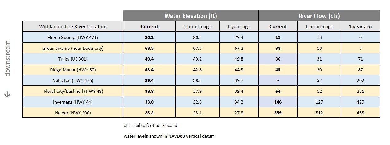
- Near US 301 (Trilby), the Withlacoochee rose 2 feet and flows tripled in mid-September, but now conditions are now back down to where they started the month.
- Near SR 50 (Ridge Manor), where the river also rose nearly 2 feet and flows quadrupled by mid-September, levels and flows have been declining the past couple weeks but remain higher than they were a month ago.
- At CR 476 (Nobleton), the river rose 1.5 feet in September, cresting on September 22nd, and has dropped almost 0.5 feet since then.
- At Hwy 48 (Bushnell/Floral City), the Withlacoochee River rose 1 foot in September, cresting on the 23rd, and has only declined about 2 inches since then.
- From Hwy 44 past Hwy 200, river levels and flows saw slight increases in September, but both are already declining again due to minimal rainfall in recent days.
- We’ll need a wetter than normal fall and winter, or we could see record low levels by next spring.
- The table below compares current river levels and flows to what they were last month and last year. Remember, last year’s levels were also very low for early October.
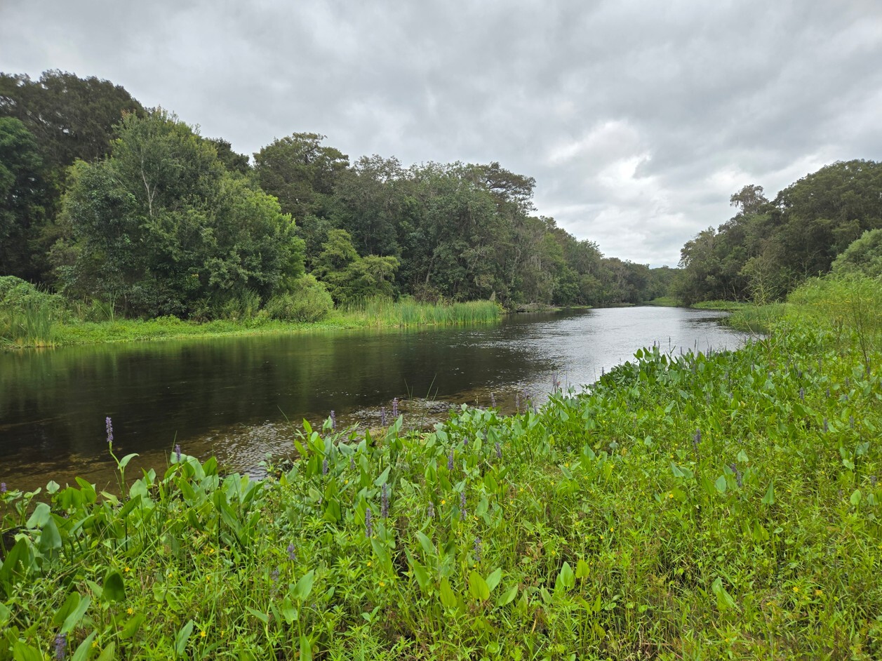
Remote Section of the Withlacoochee River near Potts Preserve (September 2026)
Tsala Apopka Chain of Lakes:
- The big news is we’ve finally been able to move water into the Tsala Apopka Chain of Lakes from the Withlacoochee River over the past couple weeks.
- This is because of heavy rainfall in the Green Swamp earlier in September that sent a temporary wave of water downstream along the river.
- The reality is that these river inflows aren’t making much of a difference everywhere yet.
- Normally, we’d be able to share the river inflows evenly between all three pools of Tsala Apopka.
- But lingering impacts from this extended drought are preventing that.
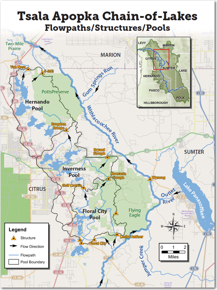
- While we can currently move water into the upstream-most Floral City Pool, water levels are still too low throughout the lake chain for us to physically move enough of that water northward into the Inverness and Hernando Pools yet.
- We’ve got structures open, but no appreciable water can make its way from Floral City to Inverness, until Floral City gets high enough for the canals to fill up and be able to move the water.
- This is a unique situation, the likes of which we haven’t seen in decades.
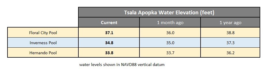
- Over the past month, the Floral City Pool has risen about 13 inches, mostly due to river inflows, while the Inverness and Hernando Pools have seen little change.
- We’re hoping to get more rain in the Green Swamp and along the river upstream, to allow us to continue to bring water into the lake chain so that all three pools can benefit.
- That may happen over the next several weeks/months, but it’ll be a slow process that would require a lot more rain.
- Of course, heavy rainfall directly over the lakes themselves will also provide an immediate rise to lake levels, we just haven’t seen too much of that lately either.
- All three pools of Tsala Apopka remain about 4 or 5 feet below their high levels.
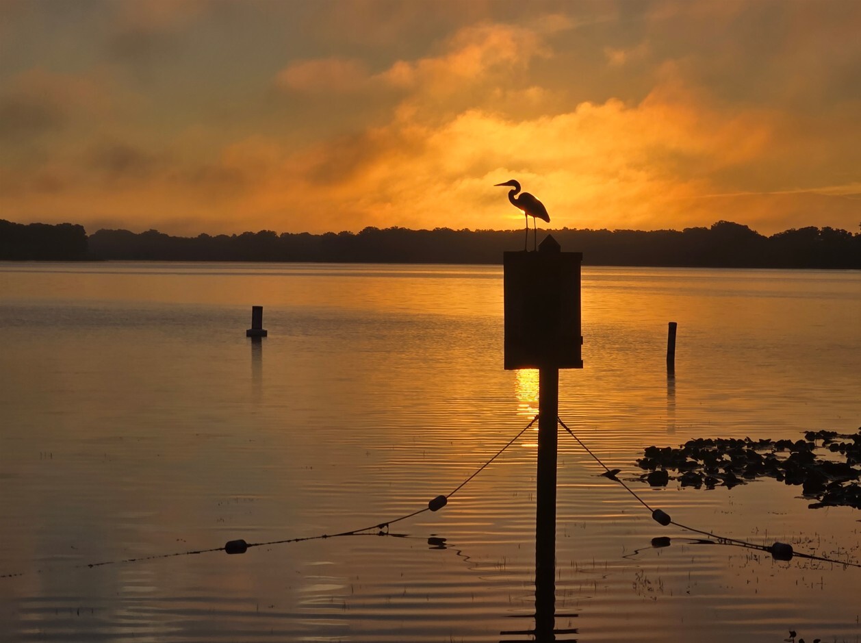
Heron Sunrise Eclipse over Lake Henderson (September 2026)
Lake Panasoffkee and Wysong:
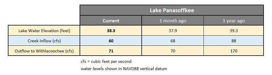
- Lake Panasoffkee saw rising water levels in September, but they remain lower than average for this time of year.
- The lake rose about 4 inches over the past month, mostly due to some good rainfall earlier in September, and because of rising water levels on the Withlacoochee at the Outlet River.
- Inflows to the lake from Little Jones Creek and Shady Brook, rose briefly in mid-September from rainfall, but have since steadily dropped back down to where they were a month ago.
- Outflow from the lake to the Withlacoochee followed a similar trend in September, with temporarily higher flows mid-month followed by declining flows to match early September numbers.
- The Wysong structure, located 3 miles downstream of Lake Panasoffkee, spans the entire Withlacoochee River.
- The main gate (230-foot-wide) of Wysong remains fully raised, while the independent gate (19-foot-wide) is partially raised.
- River levels immediately upstream of Wysong rose about 8 inches in September but remain at lower than normal levels due to extended drought conditions.
- The water elevation on Lake Panasoffkee is currently 12 inches lower than it was a year ago.
- With the dry season now beginning, it’ll take a wetter than normal fall and winter to raise Lake Panasoffkee levels further.
Lake Rousseau and the Lower Withlacoochee River (from Dunnellon to the Gulf of America):
- By now you are probably aware of the recent flood warnings at Dunnellon and along the lower portion of the Rainbow River.
- Water levels in these areas don’t rise much unless we’re experiencing flooding along the entire Withlacoochee from heavy widespread rainfall…
- …and that has certainly not been the case this year, with the extended drought conditions.
- Hydrilla (an invasive aquatic vegetation) has grown quickly in that portion of the river this summer.
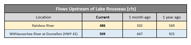
- Along a 5-mile stretch from the US 41 bridge downstream to Lake Rousseau, this hydrilla is acting like a dam, causing river levels at Dunnellon to rise 18 inches higher than normal.
- Officials from the Florida Fish and Wildlife Conservation Commission (FWC) are planning a treatment in the next few weeks to remove the excessive hydrilla and help get the river back down to normal.
- River flows entering Lake Rousseau have declined due to this hydrilla blockage and are currently 45% lower than a year ago.
- The water level on Lake Rousseau, from the Goldendale Boat Ramp west to the Inglis Dam, is normal.
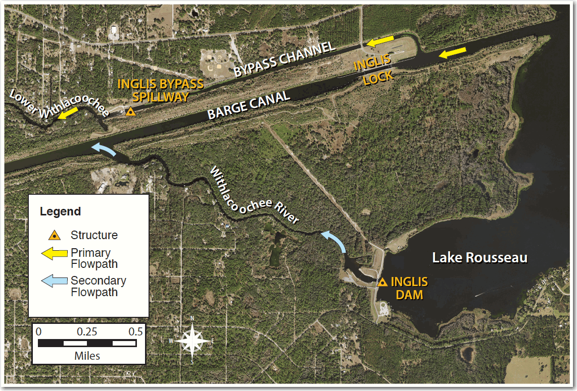
- Flow that enters Lake Rousseau from the east, exits through water control structures on the west end of the lake.
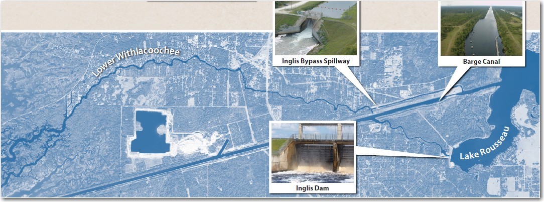
- There are two structures that release water from the lake (see map below).
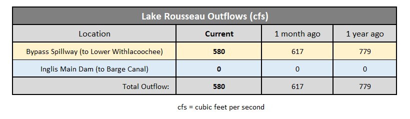
- The primary outlet from Lake Rousseau is the Inglis Bypass Spillway which provides continuous freshwater flow to the Lower Withlacoochee River.
- The Inglis Bypass Spillway is currently flowing at 41% of its capacity, down 12% from last month.
- Freshwater flow to the Lower Withlacoochee River is 26% lower than it was a year ago, due to below average rainfall in 2026.
- The Inglis Main Dam, which was closed 19 months ago, remains fully closed and won’t open again until Withlacoochee River flows increase substantially.
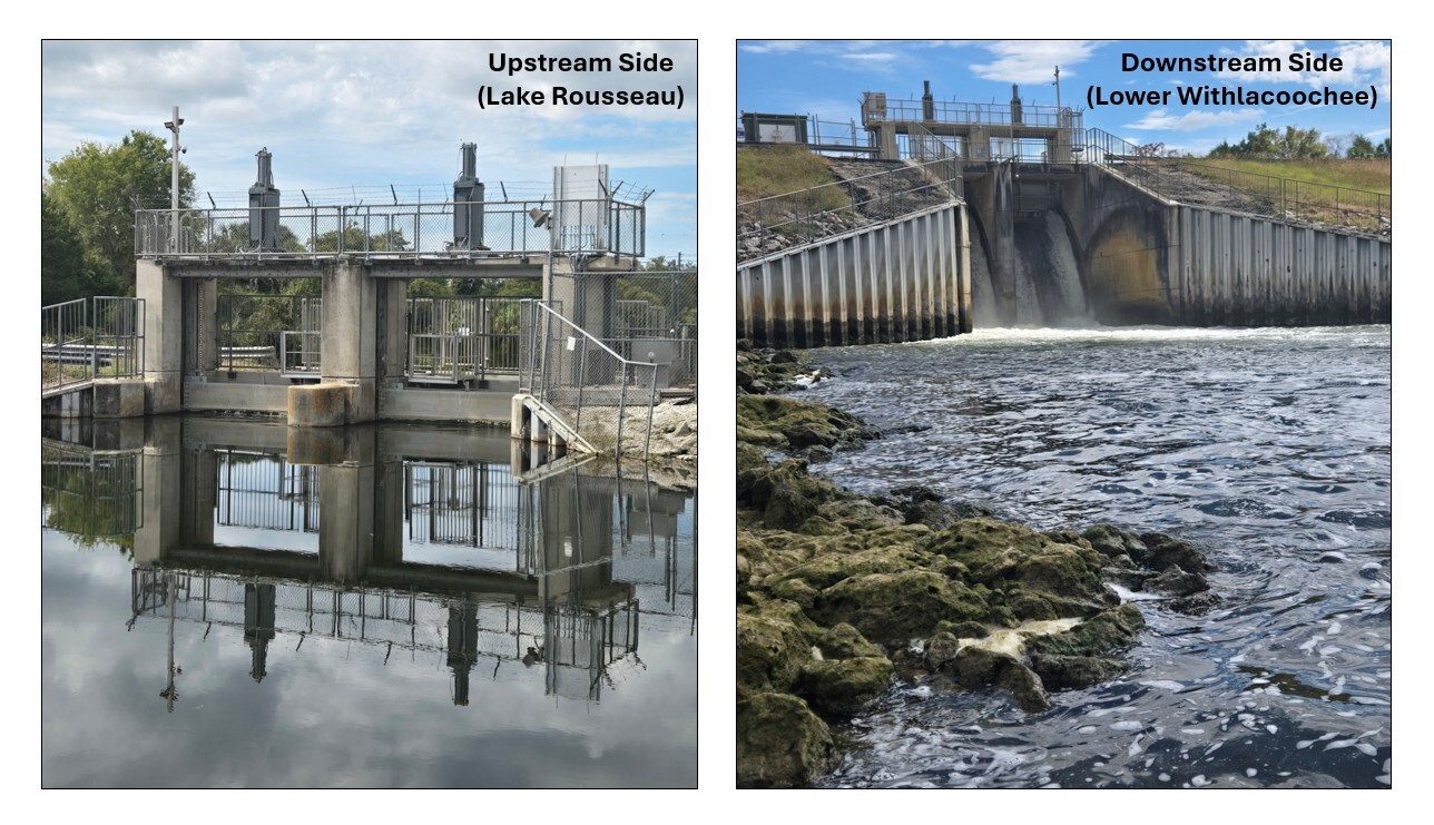
Inglis Bypass Spillway (photos taken September 2026)
Hope you have a great October!
Mark
Mark Fulkerson, Ph.D., P.E.
Chief Professional Engineer
Southwest Florida Water Management District
(352) 269-6073 (office)
(352) 279-4493 (cell)
|
|
|
|
|
|
|
|


|
Southwest Florida Water Management District | 2379 Broad Street, Brooksville, FL 34604-6899 |
|
If you do not want to continue receiving emails about these projects, click Unsubscribe. To manage your Southwest Florida Water Management District subscriptions, click Manage Preferences. |