Withlacoochee River System Update - 7/7/2026
Southwest Florida Water Management District sent this bulletin at 07/07/2026 04:38 PM EDT
 |
Withlacoochee Drought Conditions Persist
Rainfall:
- A wet May seemed to promise that our rainy season was beginning early this year, but after a less than stellar June, we’re back to where we started.
- And the drought that has gripped our region for over a year, doesn’t want to let go quite yet.
- We have seen some rainfall throughout the region lately, but like last summer, it’s been scattered and fast moving, ensuring we don’t get the widespread heavy showers we need to help bring water levels back to normal.
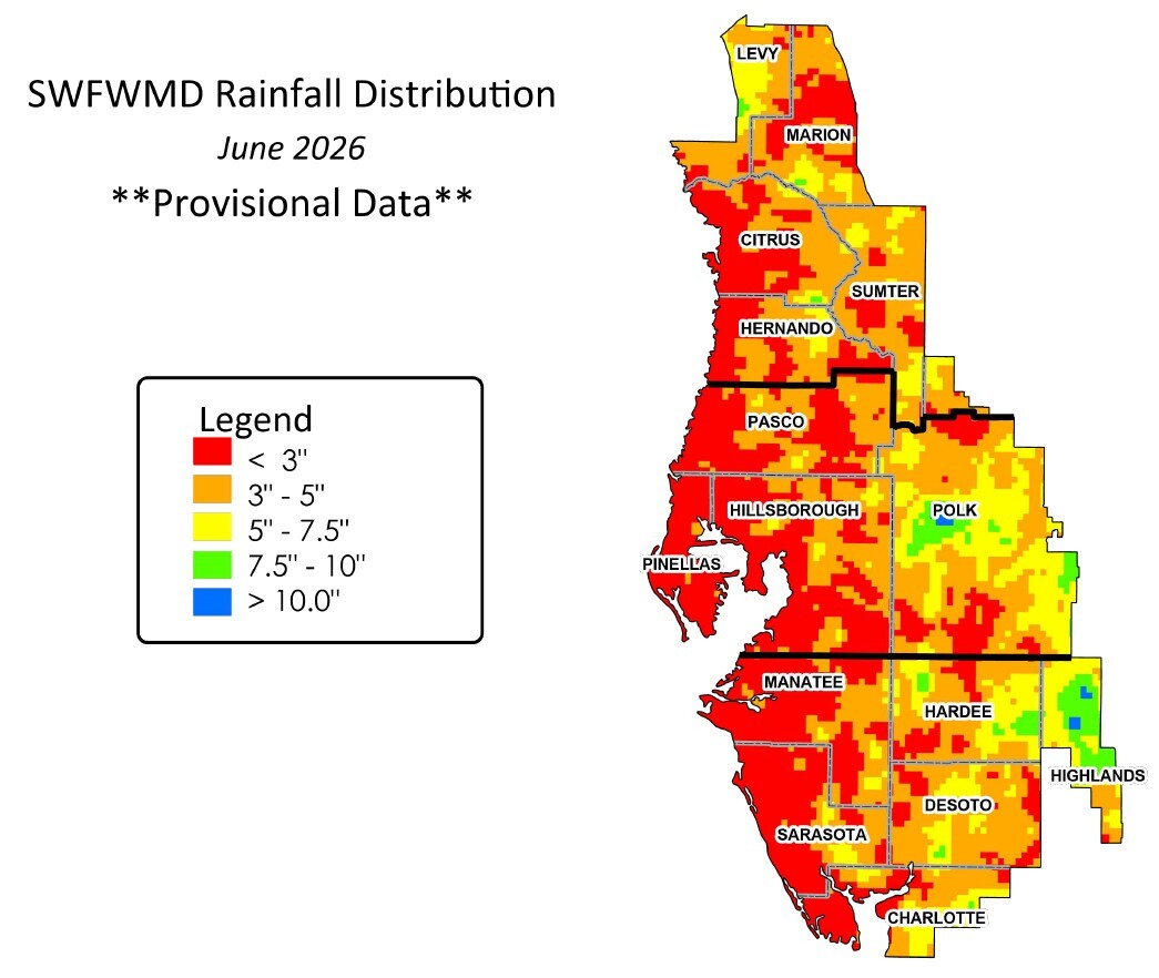
- In June, our region received 3.6 inches of rainfall, less than half the historical average for the month (7.5 inches).
- So far this year (January – June), we’ve received about 17.3 inches of rain, below the historical average for the first 6 months (23.4 inches).
- And July hasn’t been much better. A week in, we’ve averaged 0.6 inches of rain, but we need 8.3 inches in July just to break even.
- And if we consider the past 12 months, were about 14 inches below average for rainfall. That is very significant!
- Aquifer (groundwater) levels remain well below normal, currently in the 14th percentile for this time of year, and much lower than last year (51st percentile). Remember, the 50th percentile is average.
- The bottom line is we need a ton more rain over the entire area to help us recover from this extended drought.
- The figure below shows how much rainfall different areas received last month.
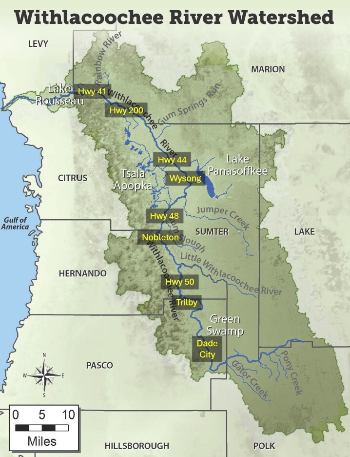
Withlacoochee River (from the Green Swamp downstream past Hwy 200):
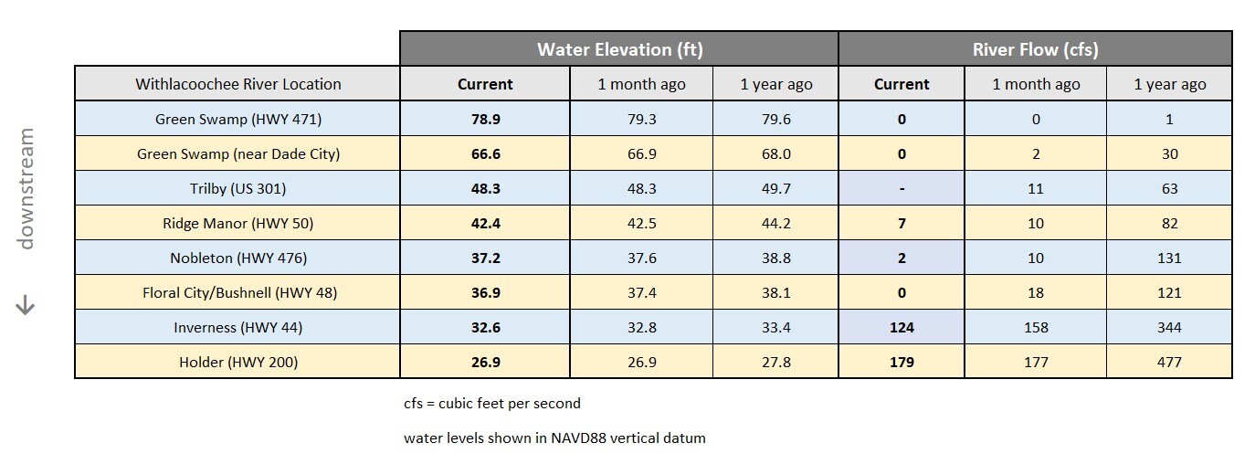
- As July begins, water levels are still declining along the Withlacoochee River.
- Over the past month, the river dropped an average of 3 inches.
- There’s no measurable flow exiting the Green Swamp, and the river is nearly stagnant all the way from there to Lake Panasoffkee.
- Most summers, we don’t see river levels rise until July or August, because rainfall must first accumulate in the swamps and creeks that provide flow to the river.
- But this summer, we’re already so low, that it’s going to take a lot more rain before water levels and flows increase again.
- While this is a unique situation…
- …in the past 30 years, the Withlacoochee River has been lower than this 3 times: in 2000-2001, 2006-2007 and in 2012.
- Each of those times, we went through an extended period of below average rainfall, like we’re experiencing now.
- The river will rise again, but not until its watershed receives surplus rainfall over a period of several weeks/months.
- The table below compares current river levels and flows to what they were last month and last year.
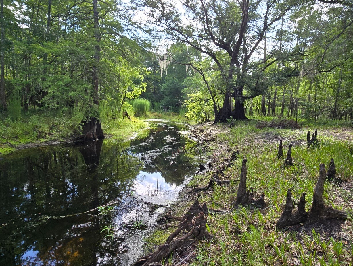
The Withlacoochee River Remains Low in the Green Swamp (June 2026)
Tsala Apopka Chain of Lakes:
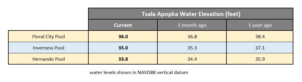
- With minimal rainfall in recent weeks, all three pools of the Tsala Apopka Chain of Lakes plunged lower last month.
- The Floral City Pool dropped 9 inches in June, while the Inverness and Hernando Pools fell 4 and 7 inches, respectively.
- Rainfall has been scattered, with some areas receiving more than others, but overall there hasn’t been nearly enough rain to prevent the lakes from dropping.
- During the summer months, the Tsala Apopka lakes need 8 inches of rain across the entire area, just to maintain the same level and not drop.
- Every day that it doesn’t rain, water levels drop due to evaporation and downward leakage to the underlying Floridan Aquifer.
- All three pools are currently 4 to 5 feet lower than their target high levels.
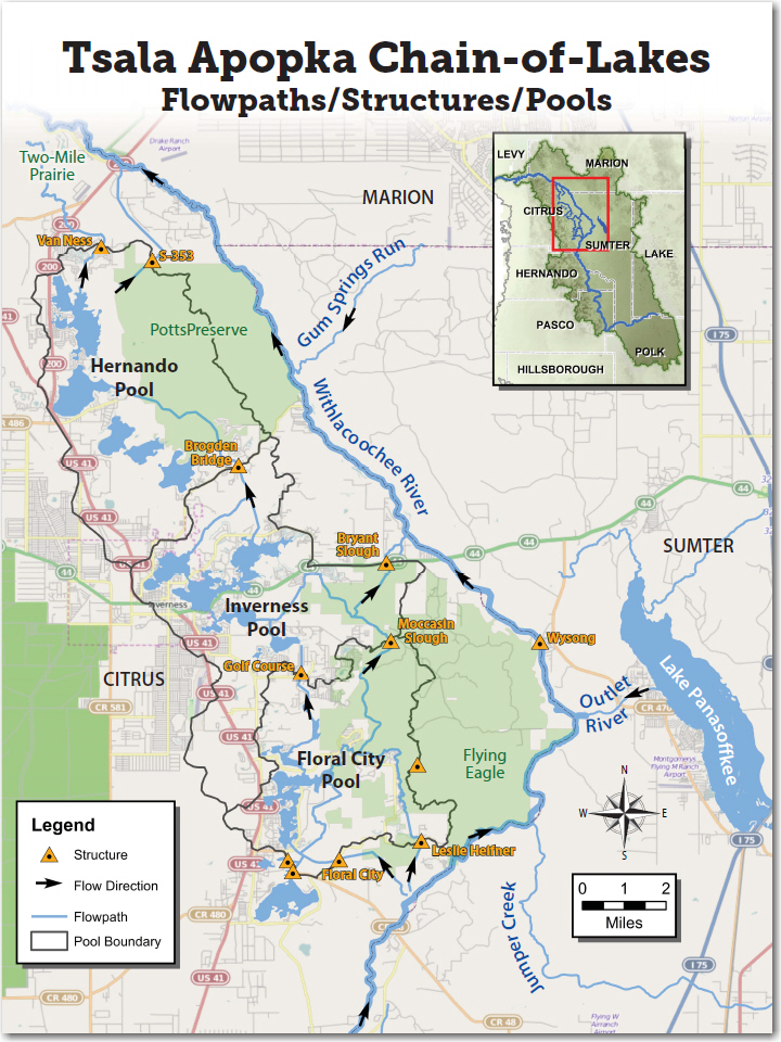
- All water control structures in the lake chain remain closed, helping to conserve water in the lakes.
- If the Withlacoochee River rises enough this summer, we may have an opportunity to move water into the lake chain, but for now water levels are just too low everywhere.
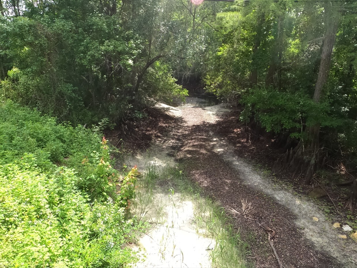
Dry Section of Orange State Canal (June 2026)
Lake Panasoffkee and Wysong:
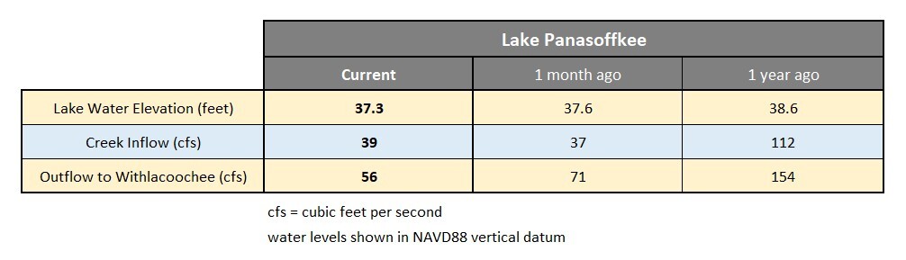
- In June, the Lake Panasoffkee area received about 3.8 inches of rainfall, less than half the historical average for that month.
- Creeks that provide continuous flow into the lake, showed minimal change in recent weeks.
- Lake Panasoffkee dropped 3.5 inches over the past month and is currently about 16 inches lower than it was a year ago.
- Outflow from Lake Panasoffkee to the Withlacoochee River declined by 20% over the past month.
- Downstream along the Withlacoochee River at the Wysong Structure, river levels held relatively steady in June and the first part of July.
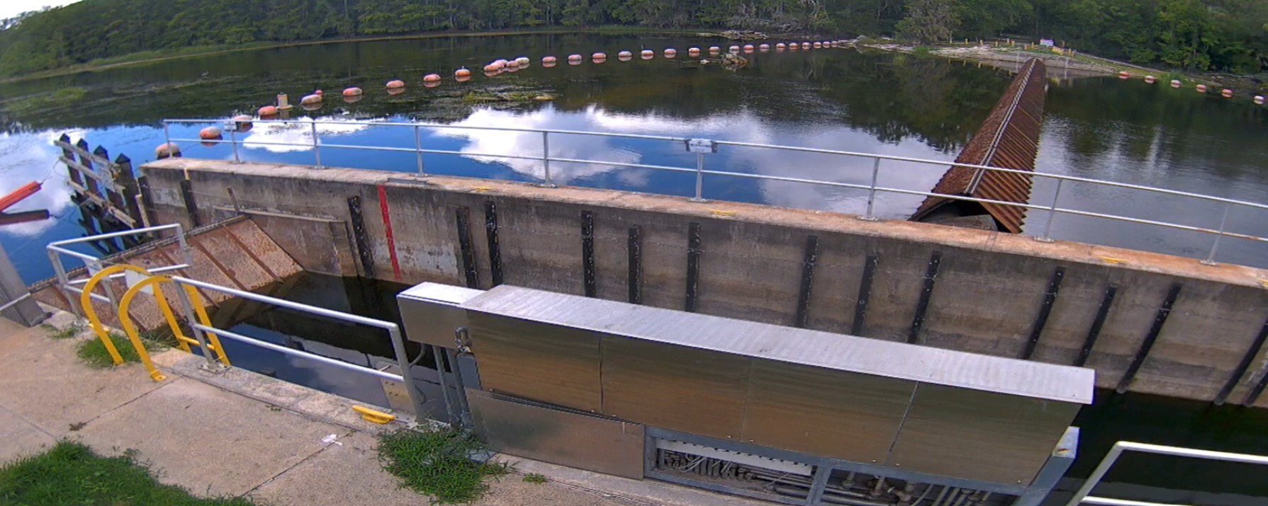
- Currently, the main gate (230 foot wide) at Wysong is fully raised, while the independent gate (19 foot wide) is fully lowered.
- Since there is minimal flow along the Withlacoochee River due to extended drought conditions, Wysong is unable to provide any benefit to river levels right now.
- Repairs and improvements to the Wysong Structure were completed in late June.
- In July, crews will be cleaning up the site and making final updates to the navigation lock programming.
Current View of Wysong Structure (July 7, 2026)
Lake Rousseau and the Lower Withlacoochee River (from Dunnellon to the Gulf of Mexico):
- There were minimal changes at Lake Rousseau and the Lower Withlacoochee River over the past month.
- River flows are still low upstream, limiting what can flow into and out of Rousseau.
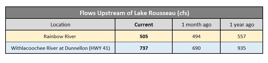
- Rainbow River flows increased 2% in June but remain 9% lower than a year ago.
- Withlacoochee River flows near Dunnellon increased slightly last month but are substantially lower than a year ago.
- Water levels on Lake Rousseau have stayed relatively constant over the past month.
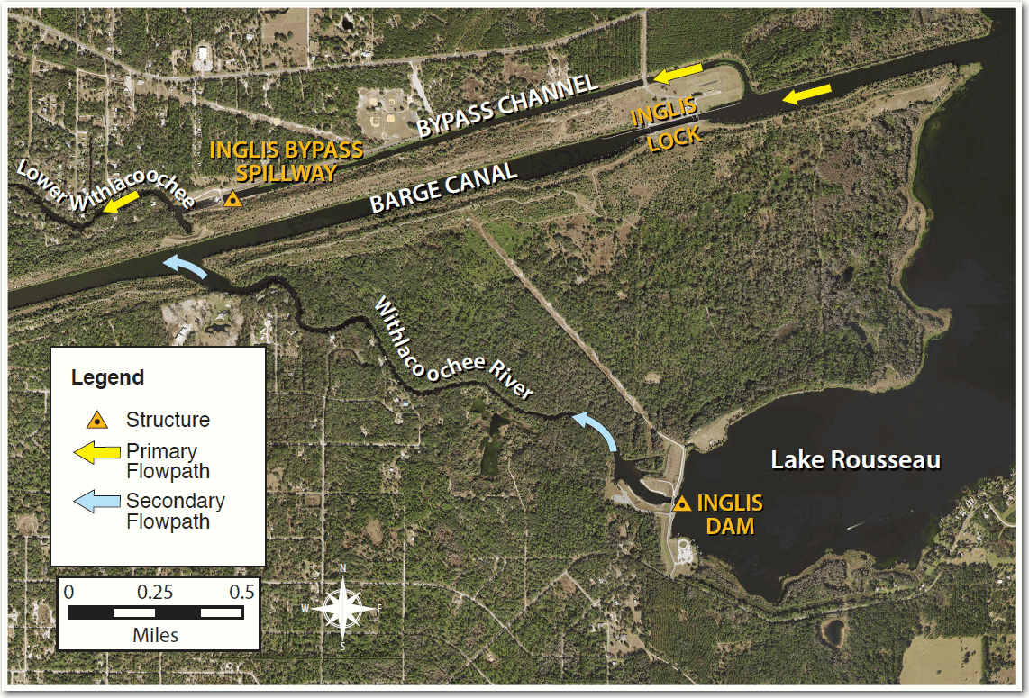
- Flow that enters Lake Rousseau from the east, exits through water control structures on the west end of the lake.
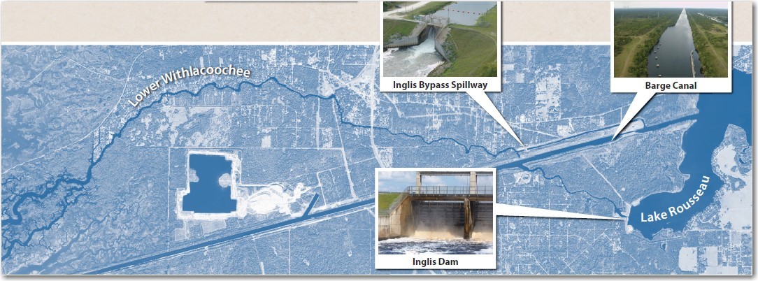
- There are two structures that release water from the lake (see map below).
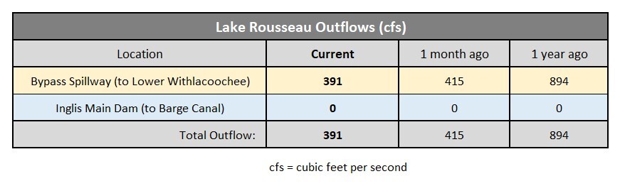
- The primary outlet from Lake Rousseau is the Inglis Bypass Spillway which provides continuous freshwater flow to the Lower Withlacoochee River.
- The Inglis Bypass Spillway is currently flowing at 28% of its capacity, down 7% since last month.
- Freshwater flow to the Lower Withlacoochee River is less than half of what it was a year ago.
- The Inglis Main Dam, which was closed 16 months ago, remains fully closed and won’t open again until Withlacoochee River flows increase substantially.
Hope you had a great Fourth of July!
Mark
Mark Fulkerson, Ph.D., P.E.
Chief Professional Engineer
Southwest Florida Water Management District
(352) 269-6073 (office)
(352) 279-4493 (cell)
|
|
|
|
|
|
|
|


|
Southwest Florida Water Management District | 2379 Broad Street, Brooksville, FL 34604-6899 |
|
If you do not want to continue receiving emails about these projects, click Unsubscribe. To manage your Southwest Florida Water Management District subscriptions, click Manage Preferences. |