
Withlacoochee River System Update - 2/2/2026
Southwest Florida Water Management District sent this bulletin at 02/02/2026 02:43 PM EST![]()
 |
Frigid Temps and Low Water Levels
Rainfall:
- It has been downright cold lately.
- And it looks like the cold weather will be hanging around a little while longer.
- In terms of rainfall, we’ve started 2026 right where 2025 left off…with another below average month.
- Last month our region received just 1.0 inches of rainfall, far below the historical average for January (2.7 inches).
- We’re in a double-digit deficit for rainfall now and our region’s water resources are certainly showing it.
- And there’s still 4 months remaining in our dry season.
- Unless something drastically changes, our region’s lakes, rivers and aquifer could be headed toward some record low levels by summertime.
- The figure below shows how much rainfall different areas received last month. All areas received below average rainfall in January.

Withlacoochee River (from the Green Swamp downstream past Hwy 200):
- After very little rainfall in January, water levels and flows along the Withlacoochee River continue their normal wet season declines.
- During the winter months, when the weather is cooler and vegetation is dormant, these declines are relatively slow.
- But during the warmer spring months, and into the start of summer, declines can be drastic.
- Last month, river levels dropped 2-3 inches while river flows declined an average of 27% in January.
- Withlacoochee water levels are currently 2 to 3 feet lower than they were a year ago, and flows are only a fraction of what they were last year at this time, because of low rainfall in 2025.
- The more dramatic statistic is that many areas are already experiencing lower water levels and flows than they did at the end of last year’s dry season.
- And with our sharpest declines expected this spring, we could be in store for some record low water levels by early summer.
- Keep in mind these fluctuations are completely natural, and river levels rise and fall each year based on varying rainfall amounts.
- The table below compares current river levels and flows to what they were last month and last year.


Water falls over one of many natural outcroppings along the Withlacoochee River (January 2026)

Tsala Apopka Chain of Lakes:
- With our dry season halfway over, water levels continue to naturally decline in the lake chain.
- All three pools fell another 3-5 inches in January.
- Since the start of our dry season (October), water levels have already dropped more than a foot.
- Although this trend is normal during our dry season, with already low water levels from minimal rainfall in 2025, the impact is substantial.
- As water levels decline, the surface area of the lake chain also shrinks.
- Normally, the lakes themselves are only about a third of the overall water surface, which also includes miles of canals and expansive shallow freshwater marshes.
- Many of those shallow marsh areas are already dry with water restricted to the deeper canals or channels.
- We’ve done everything in our power to slow down these natural declines, including continuing to bring in available river water.
- Structures have been open since July, but with low river conditions, the amount of water available to flow into the lakes is negligible and lake levels continue to drop.
- All three pools are currently about 2.5 feet lower than they were a year ago.
- During the springtime we can expect much sharper declines, possibly another 2 feet or more (vertically).


Slight flow enters the Tsala Apopka Lake Chain through the Orange State Canal (January 2026)

Lake Panasoffkee and Wysong:
- Lake Panasoffkee receives continuous spring flow from creeks that flow into the lake from the east and aquifer levels that are generally higher than lake levels.
- Over the past month, spring flow through these creeks has steadily declined as aquifer levels throughout the region continue to naturally drop during the dry season.
- In January, the water level on Lake Panasoffkee fell about 2 inches, which is a normal rate of decline for this time of year.
- Outflow from the lake to the Withlacoochee River also continues to decline.
- Lake Panasoffkee water levels are currently 7 inches lower than a year ago.
- The Wysong structure, located 3 miles downstream of Lake Panasoffkee, spans the entire Withlacoochee River.
- The main gate (230-foot-wide) of Wysong remains raised, helping to prolong the natural decline in upstream water levels.
- The independent gate (19-foot-wide) remains partially lowered, allowing river flows to pass downstream.
- Both gates at Wysong may need to be lowered in February, as the Withlacoochee continues to experience low flow conditions.

Successful habitat restoration project on District lands (January 2026)

Lake Rousseau and the Lower Withlacoochee River (from Dunnellon to the Gulf of Mexico):
- As Withlacoochee River flows upstream have continued to decline, less flow is also entering Lake Rousseau and passing to the Lower Withlacoochee River.
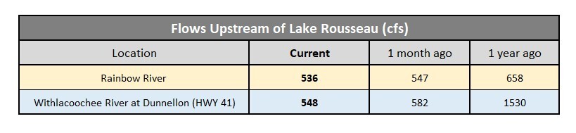
- The Rainbow River (powered by Rainbow Springs) joins the Withlacoochee near Dunnellon, adding a much-needed boost of flow prior to the Withlacoochee River entering Lake Rousseau.
- This ensures continuous flow to the Lower Withlacoochee River, even as upstream river flows continue to decline.
- Downstream of Dunnellon, the Withlacoochee River enters Lake Rousseau, an in-stream lake formed over a century ago with flood control structures near Inglis.
- Combined flows from the Rainbow and Withlacoochee Rivers are recorded at the Dunnellon (Hwy 41) gauge.
- Rainbow River flow (which reflects changes in aquifer levels) decreased by 2% last month.
- Overall, flows into Lake Rousseau are only a third of what they were a year ago, due to much less rainfall throughout the Withlacoochee Watershed in 2025.
- Water levels on Lake Rousseau have stayed relatively constant the entire month of January.
- There is a potential for Lake Rousseau water levels to decline in the coming months if river flows continue to decline from expected drought conditions.
- Flow that enters Lake Rousseau from the east, exits through water control structures on the west end of the lake.
- There are two structures that release water from the lake (see map below).
- The primary outlet from Lake Rousseau is the Inglis Bypass Spillway which provides continuous freshwater flow to the Lower Withlacoochee River.
- The Inglis Bypass Spillway is currently flowing at 35% of its capacity, down 6% from last month.
- When the Bypass Spillway reaches maximum capacity, the Inglis Main Dam is opened, discharging excess water from Lake Rousseau to the Barge Canal.
- This provides flood protection to the Lower Withlacoochee River when the river upstream of Lake Rousseau is experiencing high water conditions.
- The Inglis Main Dam, which closed a year ago, remains fully closed and won’t open again until Withlacoochee River flows increase substantially.
- Water clarity in Lake Rousseau and the Lower Withlacoochee River is noticeably clearer, a trend often seen during the dry season when nearly all river flows are coming from groundwater and springs.

Idyllic winter day along the Lower Withlacoochee River (January 2026)


Stay warm and have a wonderful week!
Mark
Mark Fulkerson, Ph.D., P.E.
Chief Professional Engineer
Southwest Florida Water Management District
(352) 269-6073 (office)
(352) 279-4493 (cell)
|
|
|
|
|
|
|
|
|
Southwest Florida Water Management District | 2379 Broad Street, Brooksville, FL 34604-6899 |
|
If you do not want to continue receiving emails about these projects, click Unsubscribe. To manage your Southwest Florida Water Management District subscriptions, click Manage Preferences. |